If you are a frequent beach stroller, you have at various times seen small, startlingly perfect circles or rings a half inch or more in diameter on the beach. If you looked at the sand surface beyond the edge of your beach blanket, you may have noticed numerous small holes in the sand. On some parts of the beach, you might have noticed small mounds or blisters pushing up the sand, again spaced at regular intervals. And if you have walked a long way along a beach, you almost certainly have encountered patches of sand that were so soft that it was very difficult to continue your walk. If you were driving on the beach, you may have even gotten stuck in that patch of soft sand.
What do all of these observations have in common? All of these features are caused by the beach taking in and then exhaling air. A beach is alternately submerged, reworked by waves, saturated with water, and then, on the falling tide or after a storm, exposed to the air, allowing water to drain from the beach and be replaced by air. On the next cycle of submergence, water again saturates the beach, displacing the air. In the process, this bellows effect generates a variety of water and air escape structures. Even the most casual observer cannot miss the fact that the beach is “airy,” as trains of bubbles stream out of tiny holes in the uppermost part of the swash on a rising tide.
The grains of sand that make up most beaches are imperfect spheres that, when packed together, retain open spaces between them. These voids, or pores, between the grains of sand on the beach are filled with water or air (along with microorganisms) depending on the level of the tide. There are two sources of water in beaches. The most obvious is the ever-present ocean, with its crashing waves stirring up the sand grains. Less apparent is the flow of groundwater into the beach from the adjacent land.

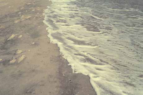
Bubble trains in swash (lower right) appear as lines of small circles, the result of air escaping into the water as the swash passes over an air hole. The wave swash is just breaking over the berm crest, soaking into the beach. Note the line of concentrated foam at the edge of the swash; air and water are filling porous beach sand. To the left are clumps of foam where the previous swash soaked into the beach, displacing air in the pores.
On every shoreline except those in arid and Arctic climates, freshwater is constantly flowing into the sea through the beaches. The amount of flow depends upon the elevation of the lands immediately adjacent to the beach and on the local rainfall. Thus, a tropical beach on a rain forest–covered barrier island in northern Ecuador will have much more water flowing through it than will a beach in arid northern Chile.
This outward-flowing water could, in some instances, actually add to the rate of shoreline retreat. The theory is that the outward pressure on beach sand from the seaward-flowing water will make it easier for the waves to remove sand grains. This explanation is probably a minor factor compared to the effect of a high freshwater discharge saturating the beach and thus increasing the amount of backwash versus wave swash.
The amount of water that beach sand can contain is measured by the porosity of the sand, expressed as the volume of pore space between the grains. Typical beach sands have porosities between 20 and 50 percent, meaning that up to half of the volume of a beach is composed of air or water in the spaces between sand grains. The pores are interconnected, allowing water and air to flow within the sand, which is measured by permeability, or the rate at which water can flow through the sand. Pour a bucket of water onto the dry beach. The water disappears, soaking into the beach by moving through and filling the pores. Gravity pulls the water down until it reaches a level where it completely fills the pore spaces. The top of this zone of saturated pore spaces is the groundwater table.
Presupposing that a beach has perfect sorting of a single grain size, porosity is independent of grain size, but permeability is not. Fine beach sand allows much less water to flow than coarse beach sand or gravel because the pore spaces in fine sand are very small and there is greater friction between the pore water and the pore walls (the grains). A boulder beach has both high porosity and high permeability, which means that as a wave breaks on the boulders, much of the water is immediately absorbed into the interstices, or large spaces, between the rocks. The result is that the backwash from the wave is reduced because much of the wave water is lost in the boulders. On the other hand, a wave that breaks on a fine-sand beach loses little of its volume of water because the permeability of fine sand is low. Thus, almost all of the wave water returns seaward in the backwash. In addition, size sorting must be factored in when porosity and permeability are considered. Specifically, the smaller grains in poorly sorted sediments will fill in the pores between the larger grains, reducing porosity and contributing to the friction factor that increases resistance to fluid flow through the sediment (i.e., potentially reducing permeability). Fine- to very-fine-sand beaches tend to be well sorted, but coarser-grained beaches often show poor sorting. As discussed in chapter 3, these differences in permeability also explain why fine-sand beaches are flatter than coarse-sand or gravel beaches.
Bubbly sand is produced by two natural mechanisms. The first process occurs when swash mixes air and sand, trapping air bubbles just below the beach surface. Trapping of foam may play a part as well. Hans Reineck noted that this occurs on beaches with steeply sloping upper intertidal zones that experience rapid sedimentation from swash, trapping air bubbles. This type of entrapment is also common on tideless lake beaches when air bubbles are concentrated in the berm crest, probably during small storms. When the sand dries, near-surface bubbles collapse, leaving shallow pits; also, one can stomp on the beach and cause a field of collapsed bubble pits well away from the footprint.
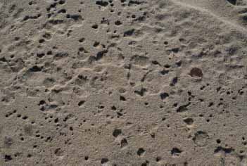
Collapsed bubble holes just below the surface of the beach. The holes resulted from the mixing of air and sand in the swash zone, possibly associated with foam. Typically, these are concentrated at the berm crest, and stomping on or simply walking on the beach will generate their collapse and the resulting pitting. The U.S. penny is shown for scale.
The second phenomenon that produces bubbly sand is more significant, in that the bubbly texture can be produced farther below the surface and can result in thicker layers of soft sand. It is also a much more widespread occurrence. The air entrapment in the beach results when air from the pores in the sand is forced upward through the beach on a rising tide. During low tide, the water table in the beach goes down and the pore spaces between the sand grains fill with air. As the tide rises, the water table in the beach also rises, and the surface sand becomes wet, so the air in the beach is trapped between layers of water-saturated sand. The air is forced upward, and some escapes through sand holes in the beach, but discrete air bubbles also form in the sand and are trapped by overlying layers of wet sand or by finer sand layers, or by both. The best-developed bubbly sand is found on the upper parts of fine-sand beaches with high tidal amplitudes. Well-sorted sand (sand with a small range of individual grain sizes) with little shell material and no mud also favors entrapment of air bubbles.
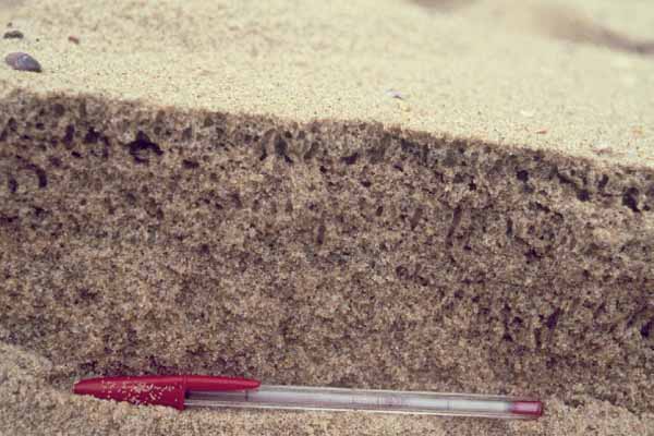
Bubble sand seen in cross section gives the impression of Swiss cheese. This Brazilian beach shows not only the variation in the size and distribution of the holes produced by trapped air in the beach, but also some movement of that air (vertically elongated holes).
Often there is no surface expression for bubbly sand. However, one only has to walk on such a beach to know one has found soft sand because every step will take effort: First the foot sinks as surface pressure causes the holes and pores to compress and collapse, and then the foot must be pulled out of the compressed sand.
Most bubbly sand extends only through the surface layers, a few inches into the beach, but we have observed bubbly sand to extend as much as 1.5 feet (more than 45 cm) below the surface on the beach at Sapelo Island, in the U.S. state of Georgia, a depth that will conquer most four-wheel-drive vehicles. Driving a vehicle onto such a surface will result in getting hung up to the axles, as we have learned.
The spherical to flattened-oval holes that make up bubbly sand can be seen in a wedge of sand just extracted from the beach, or on the wall of a carefully excavated trench. The cavities range in size from 0.1 to 0.98 in (3 to 25 mm), giving the beach a Swiss cheese appearance. Near the beach surface the holes are spherical, but they become flattened somewhat due to the weight of the sand, which increases with depth from the surface. When pressure is applied, the cavities collapse, resulting in the sand’s softness.
The bubbles in soft sands probably form as the result of two different processes: A breaking wave and swash mix sediment and air, trapping the air, or, more often, the rising tide forces air up through the beach. In the latter case, the lack of permeability in the fine wet sand at the surface of the beach does not permit the air to escape uniformly, but instead forces bubbles to form. There is more to this story than meets the eye, however. Many aspects of soft sand remain unstudied, and there is no apparent reason why the bubbly sands form in some places but not in others. Adding to the mystery is the bubbly sand found along some sandy lakeshores above normal lake level. Scientists assume that these sands became bubbly during local storms.
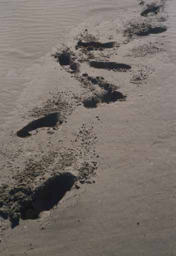
These deep footprints are a sure sign of soft sand!
Another puzzling feature is the presence of bubbles high on the sides of now cemented dunes in the Bahamas. These bubbles appear to be identical in shape and size to those that appear in the bubbly sand on beaches. Again a storm explanation is called upon, but no one knows how they came to be. Bubbles also are entrapped in some muddy sediments, but these form from gases generated by the decay of organic matter.
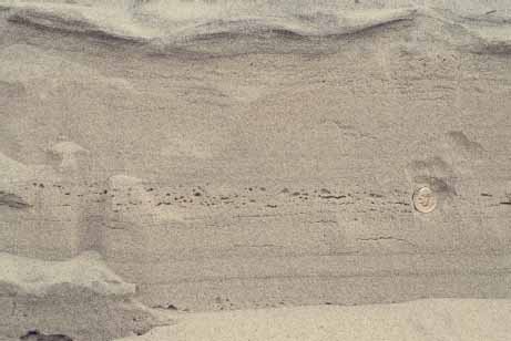
Bubble-sand layers can be buried, as seen in this trench. Note the bubble-sand layer at the base, then another layer about midway up, and finally a poorly developed bubble-sand layer near the top. This variation reflects the different conditions under which the different sand layers form, as air is trapped in the beach in repeated cycles. The U.S. dime is shown for scale.
Bubbly sand has a couple of practical ramifications. One is the problem created for those who drive vehicles on beaches, but in our view such driving is something that should be discouraged on most beaches anyway. It is also considered a minor problem for tourist beaches. A much more serious problem is that spilled oil and other liquid pollutants will penetrate farther into bubbly sand (see chapter 12) than into other sands of the same grain size. Fine-sand beaches generally allow little penetration of spilled oil, so cleanup is relatively simple and involves little loss of beach sand. Bubbly sand beaches, however, can turn a disastrous spill into a catastrophic spill as far as beach life is concerned.
Escaping air forms a large number of features at the surface of the upper beach. The names we have given these structures are not “official” names, but they are descriptive and recognizable by just about any beach stroller. One of the most common structures found on all beaches are nail holes (sand holes), so called because of their resemblance to a downward-tapering hole produced by a nail; even their variation in diameter and length is reminiscent of nail holes. Their abundance varies widely. By actual count on the upper portions of some southeast U.S. beaches, the density of hole spacing ranges from less than 1 per square foot to 200 per square foot (about 10 per square meter to about 2,200 per square meter), almost always on the upper beach near the highest reach of the swash at high tide.
The escaping air associated with these holes can be seen on a rising tide in the upper swash zone when the thin layer of swash water washes across the sand. As air escapes into the water and the bubbles are moved up and down in the upwash and backwash of the swash, bubble trains are formed. Sometimes, in response to a foot stomp, closely spaced nail holes in a dry part of the beach, away from the footprint, will collapse, forming micropits, suggesting that there is some sort of connection between the holes. Most beach strollers probably assume that such holes are produced by small organisms. Occasionally one does see sand fleas popping down these holes, but we believe they are usually occupying previously formed air holes (see chapter 9). Organisms such as sand hoppers do excavate holes that look similar at the surface, but they are typically much deeper and much less abundant than the nail holes.
If the stream of ejected air is a little stronger, it may remove sand from around the lip of the hole, making a pit. Pits also form where blisters collapse (see later in this chapter). If sand also is carried upward through the escape hole and deposited immediately, a sand volcano may form.
Where air or water moving up to the surface cannot escape through an uppermost sand layer that happens to be cohesive enough to form a trap, a cavity will form. These air or water pockets will push the overlying sand layer up into a circular dome, or blister, at the surface, a feature much like a soufflé. The trapping upper layer is usually fine sand, but salt-cemented sand (salcrete) or thin organic films of algae or diatoms may bind the sand to form the barrier that prevents air escape as well. Blisters often occur in clusters or fields, evenly and symmetrically spaced and of nearly uniform size. Such fields may be tens of feet (several meters) in length and a few feet (a meter or two) in width, reflecting a physical pattern of air buildup within the upper beach. Individual blisters sometimes have a nail hole in them, suggesting that a point was reached at which there was enough air pressure to create an escape hole.
Blisters can burst, leaving an irregular circular patch of different-colored sand (this feature is difficult to identify if you don’t actually see the blister form and pop). Alternatively, the blister’s cap can collapse or, more commonly, be decapitated and eroded off by the next cycle of swash, forming a pit, which is a depression that varies in size depending on the size of the original blister. More often, the truncated blisters and pits are smoothed over by the swash and backwash, leaving a ring structure.
Ring structures are formed almost exclusively on beaches with a high heavy-mineral content. Alternate light-and dark-colored laminae produce the rings after the laminae are domed up by air (to create blisters) and then planed off, leaving the different-colored rings. In fact, we have never seen ring structures on carbonate beaches or beaches with very low heavy-mineral content, such as those along most of the Florida peninsula. Such rings are perhaps the most spectacular of the multitude of air escape structures on beaches.
Clearly, an infinite variety of escape structures can be formed in a multitude of ways. We’ve just scratched the surface of this interesting and little-recognized phenomenon, and some of our explanations belong in the category of educated guesses. There are lots of strange things to be explained. For example, if one puts a stick or a board (perhaps obtained from the beach wrack) on the uppermost beach, the next swash that rolls over this obstruction may form a line of holes on its landward side. The edges of tire tracks and footprints likewise produce lines of nail holes and pits and may be associated with the formation of some blisters.
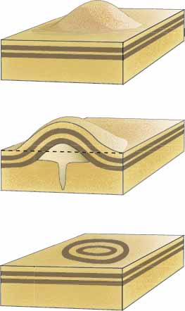
Model of the formation of a blister and its truncation to form a ring pattern on the beach. Air and water in beach sand may be trapped by a less permeable layer of surface sand, allowing a blister cavity to form. The blister may collapse or be truncated by the next swash to form a pit. If there are laminae that are distinctly different (e.g., colored heavy-mineral layers), a ring pattern will result. Drawing by Charles Pilkey.
For the scientifically inclined beach watcher interested in the minutiae of nature, the opportunities for discovery and explanation are boundless. One might try to explain by observation how the features form, why they form in some places and not others, why they are abundant on some beaches and not on others, why they are present before or after storms, and so forth.
Upper Nail holes (sand holes) vary in size and depth and in the concentration of their distribution. These holes are the most common feature found on beaches. The U.S. dime is shown for scale.
Center left A sand volcano produced by escaping water bringing sand to the surface. The finer, lighter-gray subsurface sand makes the tiny “volcano” stand out against the darker surface sand, with trails of the lighter sand going away like miniature lava flows. To the right of the volcano are similar trails of lighter sand from an opening that was eroded to produce a pit. The U.S. penny is shown for scale.
Lower left A blister forms as a cavity of trapped air that produces a raised surface. Note the pit to the left of the blister where a similar cavity was truncated. Nail holes are also visible. The Brazilian ten-centavo coin is shown for scale.
Center right A cross section through a blister showing the internal cavity, or soufflé structure. Note other blisters, pits, and air and water escape holes. The Brazilian ten-centavo coin is shown for scale.
Upper The fine sand of this beach in Gurupi, Brazil, favored the formation of a field of very small blisters (note the bumps between the pen and the swash mark line). The swash wave truncated the blisters, forming the area of holes and pits.
Lower left An analogous setting for understanding how blisters form and occur in semiregular distribution patterns is seen on this Michigan parking lot in winter. Trapped air and water form and fill cavities (light areas) between the impermeable asphalt and overlying ice layer, causing the equivalent of blisters. As on beaches, the blisters have a somewhat equant distribution. The 1 ft (30 cm) ruler and tire tracks are shown for scale.
Lower right Ring structures are produced when blister doming occurs and then is truncated by swash waves. Here the dark heavy-mineral laminae make the ring patterns more obvious. Note that the cavities left by the blisters can be seen in several of the ring structures. The U.S. penny is shown for scale.
Water, like air, is forced in and out of the beach as the tide goes up and down. If sea level were static, the water table under the beach would be slightly higher than sea level but would slope toward the sea to reach the same level at the water’s edge. Any rise in sea level (or lake level) will flood the beach (e.g., high tide, storms, wave run-up), forcing water into the beach and raising the water table, as well as saturating or partially saturating the sand above the water table. When the tide falls or the storm subsides and the water level goes back down, the direction of flow will reverse and water will escape from the beach. This flow may take the form of springs, seeps, or even water emerging from surface holes in the beach (e.g., nail holes). On the rising tide, the bellows effect even may be strong enough to form small, temporary fountains of water a few inches high. Similarly, rainfall and surface runoff on the land may soak into sands contiguous with the beach (e.g., adjacent dunes) and then emerge on the beach as springs or seeps.
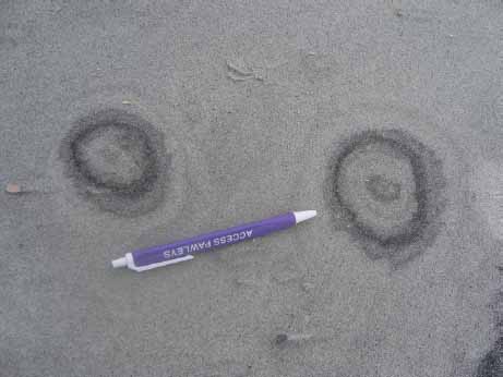
Close-up of rings.
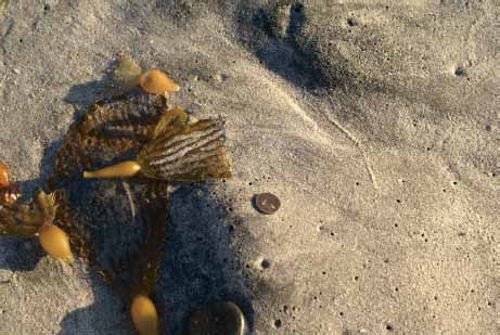
This irregular beach surface is the result of footprints that were washed over by wave swash. Note the nail holes, larger air escape holes, and probable blisters. Sand surfaces disturbed by footprints and tire tracks seem to favor air and water entrapment, resulting in more holes. The U.S. penny is shown for scale.
Water seepage from the beach face is common at low tide, and a seepage face develops where the water table and the beach surface contact each other. The associated features that form along this line are distinct: Rill marks are miniature seepage channels that commonly show dendritic (treelike) patterns at their upper end, braided patterns in the downflow direction, and associated depositional tongues, or microdeltas, at the terminus of sand transport. Looking down on rill marks is like looking out of an airplane flying over a river system with tributaries flowing from canyons and joining to form a trunk stream, which then turns into a braided stream. The variety of forms of rill marks is reflected by the many descriptive names given to these features: branching, fringy, meandering, conical, comb-shaped, comma-shaped, and tooth-shaped. Rill marks are found more often where there is some slope to the beach at low tide. These structures rarely form on the upper intertidal area. In contrast, the surface of flat beaches may be at the same elevation as the top of the water table at low tide, producing a water-saturated beach surface, which gives a mirrorlike effect. In essence, the entire beach surface is a wide seep.
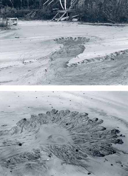
Upper A spring from which enough water is flowing to produce a small channel across the beach. Transported sand is deposited in a deltalike splay deposit in the foreground.
Lower A close-up of the spring, where water is seeping from the beach around the depression (small rills, each with a miniature depression, can be seen around the rim of the larger spring) and flowing from the bottom of the main pit. Note the three spots where the sand is being roiled up by the water outflow.
Rill marks often appear at the same elevation along a beach for a long distance. This line of marks can be an expression of the top of the water table or may be the result of an invisible, impermeable sediment layer that forces the water in the beach to move out onto the beach. Peat layers often are the cause. As noted in part I, barrier beaches move landward as a result of rising sea level, often moving over and burying salt-marsh peat that existed at the back of the beach or barrier island. Such buried salt-marsh peat layers, which sometimes appear in the intertidal zone, were covered and compacted by beach sand for as long as several thousand years before reemerging. The peat layers are impermeable, so groundwater piles up on the peat’s surface. As a result, rill marks often emerge in a line on the beach, just above the peat layer. Sometimes the peat layer is visible, but if it is not, it can often be observed by digging down below the surface a little bit.
Five fountains where water and air are escaping from the beach during a rising tide. Fountains were observed forming on the berm adjacent to the sea’s edge as well as in the first trough (runnel); the five shown here were under the water that had flooded the trough. Most of the fountains were short-lived, bubbling only for a few seconds, but some were intermittent, bubbling, then stopping, then bubbling again.
As noted previously, smaller water escape structures include nail holes as well as sand volcanoes, which form when escaping water from a sand hole carries sand to the surface, where it accumulates around the hole, like volcanic ash around a crater. Again, these are miniature structures, about i in (about 2.5 cm) in diameter, although larger spring mounds with a central pit or craterlike structure are reported in some beach sediments.
There are a large variety of other organic structures that can be mistaken for physical structures. For example, some sand volcanoes are probably organic in origin. From their burrows, ghost shrimp (Callianassa sp.) extrude mixtures of sand, water, and fecal material, which accumulate in the same conical fashion as the physically formed structure does (see chapter 9). Certain worms that live in the lower beach also extrude conical piles of muddy sand. As a general rule, the surface structures on the uppermost beach are entirely physical water and air escape features, but on the lower beach and tidal flats, features formed by living organisms may be present.
This chapter has brushed by a whole army of features that can be seen on the surface of just about any beach in the world. These features will be different on every beach to varying degrees because of multiple parameters, such as beach orientation to wind patterns, beach grain size and sorting, sand supply, heavy-mineral content, shell content, tidal amplitude, waves, and storm frequency. Much remains to be learned about these features, and they remain a fascinating puzzle, an extra and unexpected intellectual adventure for those who are willing to look at the beach as more than a pile of sand.
Left Rill marks form where groundwater seeps out of the beach, producing unique and varied patterns. The upper ends, or heads, of the rills are tiny dendritic, or branching, channels formed by erosion from the seeps. These miniature channels converge into main channels that terminate in deltalike splays of sand. Note the footprint to the left. The seeps have produced microdeltas that are covering the toe of the footprint, and a similar deposit can be seen at the end of the rill on the extreme right. A backwash lineation pattern is present between the rills. The U.S. penny is shown for scale.
Right This large water-seepage feature produced by converging rills at low tide on a beach in Northern Ireland is eroding headward (toward the bottom of the photo), and transporting sand seaward, filling in the trough (at the top of the photo).
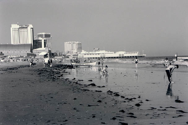
When the lower beach is saturated with water, it often has a mirrorlike, or reflective, surface, as seen in this photo of the famous Atlantic City beach in the U.S. state of New Jersey. The condition is common at low tide between the edge of the swash and the upper beach.
Sand volcanoes may form as a result of either the physical escape of water and sand or the expulsion of water and sand by burrowing organisms. The origin of the prominent sand volcano in the center of the photo is questionable; however, the smaller, similar feature to the right (above the U.S. penny, which is shown for scale) has Callianassa fecal pellets around the opening, indicating that it was formed by the burrower.