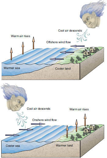
Beaches are windy places, both because they face vast stretches of open water over which wind blows from distant storms, and because of the differential heating between land and water. A summer morning’s visit to the beach might be met by a seaward-blowing breeze, but as the day wears on, the land surface heats up at a faster rate than the sea surface and the wind direction reverses. This effect is because the ocean absorbs heat energy to a greater depth than the beach and dune sand does, so the ocean warms more slowly than the land. The warm air over the land rises as it is heated, and cooler air rushes in off the ocean to replace it, forming the familiar sea breeze.
The effect of the wind is subtle on wet sands such as in the intertidal zone, where sand does not completely dry out, or on wet beaches after rains. To begin with, wet grains are not easily picked up by the wind because the water on their surfaces “sticks” to other grains and water. Here individual grains become free to move only upon drying, but they stick to adjacent moist surfaces as the wind begins to move part of the sand. The result is an adhesion surface or adhesion ripples, a pustular- to warty-looking surface where grains have moved but eventually adhered to the moist beach surface. These surfaces tend to remain damp because water in the pores between the newly adhered sand grains also tends to adhere to the grains due to surface tension. This surface tension produces a capillary action, that is, the pulling of the water column up against the force of gravity, as can be seen when a drinking straw is placed in a glass of water. The smaller the pores, the greater this effect, so adhesion surfaces are more common in damp, fine-grained sands. As water continues to be drawn to the surface, the moist-trapping effect is maintained to accumulate more sand as it blows by. These surface features are termed adhesion ripples because the tiny lumps do have some asymmetry and can be used to determine wind direction, although the pattern is distinctly unlike that of the other ripple marks described in chapter 6, or of those formed by the wind in dry sand.

Model of the origin of sea breezes. In the morning, the air rises off of the warmer sea, causing surface breezes to blow seaward, but as the land heats up and the air begins to rise, the onshore sea breeze develops. Drawing by Charles Pilkey.
Such damp sand surfaces also favor the formation of tiny sand shadows, or windrows of sand accumulating in the lee of shell fragments or other tiny obstacles. These miniature harrow structures give a strong sense of wind direction.
Although mud is not commonly associated with sandy beach environments, here and there small patches of mud may be found. For example, mud surfaces occur on low-energy, protected tidal flats, especially on the landward side of barrier beaches, and more rarely in beach troughs or on the uppermost beach on the back berm surface. If such a surface is covered with a thin film of water, and the wind blows over the surface, wrinkle marks may form in the mud. These occur as small patches of tiny ripplelike structures, only small fractions of an inch in relief. On drying, mud layers will shrink, forming mud cracks, which sometimes curl along the edges, causing the layer of mud to separate into thin mud chips. Such damp, muddy surfaces favor the growth of algae, and their thin mats, which give the surface a black color, help hold these mud chips together.
One of the effects of beaches transitioning from a wet to a dry state is the precipitation of tiny salt crystals between the grains of porous sand laminae as the salt water evaporates from the beach. These weakly cemented sands, or salcretes, are more cohesive, or sticky, than dry sand and often form crusts, resistant layers that will stand in relief when the adjacent dry sand blows away. Salcretes are most common on the upper beach or in overwash passes cut through the dune line, and they sometimes contribute to a beach surface eroding differentially so that a microtopograpky develops. These irregular surfaces cut through the parallel laminae underlying the beach. If the laminae are of different compositions (e.g., alternate layers of light and heavy minerals) or different average grain size, the result is a miniature contour pattern, curious swirls of light and dark, similar to what one might see in an aerial view of a mountainous region underlain by horizontal sedimentary rock layers.
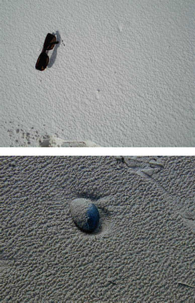
Upper Adhesion surface on a carbonate beach in the Maldive Islands. The irregular, pustular surface results from dry, windblown sand grains adhering to the damp beach surface.
Lower Adhesion surface and ripples on the beach at Portrush, Northern Ireland, including a light coating of sand on the pebble.
Less common structures associated with the differential drying out of a beach are beach biscuits, which are found on the upper beach. The upper beach and the throats of overwash passes are flooded during storms, saturating the sand. As the sand dries out differentially, subspherical, biscuit-shaped blobs of sand remain moist and cohesive while the rest of the sand dries. The wind then removes the dry sand, leaving the biscuits standing on little mushroomlike pedestals. The delicate pedestal structures tend to form after storm waves have saturated the back beach and strong winds differentially dry and sculpt the sand. The features generally do not persist, as the wind that forms them also eventually topples them.
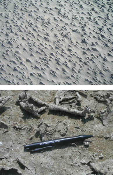
Upper Wind-generated miniature harrow marks, or windrows, on a beach surface at Ostend, Belgium. The tiny pedestals are held up by coarser grains or shell fragments that are too coarse for the wind to move, and the fine sand streams out behind the obstacle in the direction the wind is blowing, in this case from the upper left to the lower right. The euro coin is shown for scale.
Lower Where small puddles or persistent damp areas occur at the back of the beach, thin layers of mud or algal mats will accumulate. These layers will shrink as they dry out and form classic mud cracks, or the algal mats will split and curl around the edges, forming roll-up structures as seen here on Oak Island, North Carolina. Photo courtesy of Tracy Monegan Rice.
Beaches and dunes are natural laboratories in which to see the interaction of wind and dry sand. Given its greater density, water can pick up and carry much larger material than can wind at any given velocity. Turbulence in wind, however, allows grains as coarse as sand to be picked up, and wind velocity determines how far a grain will be carried before settling to the ground. Wind is nature’s best sorting agent.
Where the wind erodes and transports sands, gravel-size materials and shell hash (gravel made up entirely of shells and shell fragments) are left behind as lag deposits, forming a coarse, pavementlike surface that tends to retard further erosion. Fine materials such as silt- and clay-size particles may be completely removed from the beach-dune system and may be a contributing factor to the haze (which is mostly salt spray) sometimes seen down the length of the beach (and to the fine grit you can’t seem to get out of your mouth, hair, or eyes at the end of the day). Sand-size particles are further sorted because the wind transports coarse and fine sand differently, rolling or sliding coarser sand particles, and moving the finer sand grains by saltation, a sort of bouncing or hop, skip, and jump action. The result is a concentration of well-sorted sand.
Any obstacle to the wind will increase turbulence (a chaotic air motion that allows the grains to be picked up) around the obstacle but reduce velocity on the downwind side. The result is scour around the obstacle and sand deposition in the lee of the obstacle, sometimes giving birth to an embryonic dune. These wind shadow deposits are common along wrack lines, behind clumps of plants, and downdrift of large pieces of flotsam; they even form small windrows of sand where shells interrupt wind flow. The scour around the obstacle is analogous to the scour created by wave swash around a pebble on the beach and the formation of crescent marks by backwash. Clumps of pioneer plants and dune grass have the same effect, trapping sand and initiating the formation of embryonic dunes.
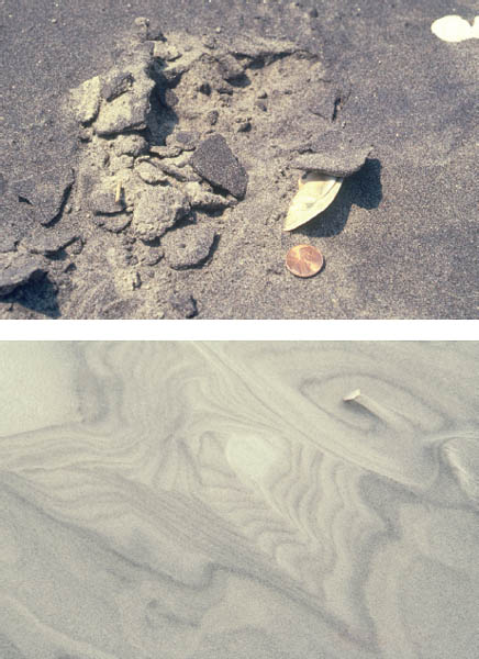
Upper Salcrete results when sand is weakly cemented by salt crystals precipitated between the grains, which happens when seawater evaporates. This layer of heavy-mineral-rich salcrete forms a crust over the quartz-rich lighter-colored sand. The brownish grains are the mineral garnet. The U.S. penny is shown for scale.
Lower Where the wind sculpts the beach by irregular down-cutting erosion through layers of different-colored sands, patterns of contour lines emerge that mimic the lines of a topographic map. Note that the shell presents a wind barrier; its presence results in a streamlined pattern. The wind appears to be blowing from the upper left.
Some of the first bedforms produced by the wind are the familiar ripple marks. Wind ripples are parallel crested, are often split along their length, and occur in fields (i.e., extensive patches of ripples), but they differ from water-wave ripples in that the ripple crests are not as sharp and the amplitude of the ripples is less. Another noticeable difference is that the sand along the crest of the wind ripple is coarser than that in the trough, the opposite of the distribution in a water ripple. This difference is because the wind cannot move these coarser sand particles by saltation, so they concentrate on the crest. On a water-laid ripple, the coarser grains are carried over the crest or avalanche into the trough, where they are partially protected from the current and are concentrated. In fact, studies have shown that where the wind is energetic enough to move all sand sizes, the average grain size of the sand making up a patch of wind ripples in their entirety is coarser than the sand underlying the rippled layer. Similarly, where the wind is strong enough only to move very fine sand, a coarser lag will be left behind and the finer sand will accumulate as very well-sorted deposits in wind shadows or when the wind velocity dies away. Similarly, the wind may concentrate sand grains of different densities (placers of different mineral compositions), giving rise to color stripes between ripples. Even when ripple marks do not form, thin placer concentrations of heavy minerals give rise to black sand surfaces.
Fields of wind ripples are common on the upper dry beach, at the toe of the sand dunes, and on the bare surfaces of the dunes themselves. Often the crests are perpendicular to the shoreline, indicating formation by winds blowing parallel to the shore. The crest orientation may change in a matter of an hour or less if the wind changes direction. Few beach visitors venture out in strong winds, and those who do experience sand transport in the little stings and pinprick sensations made by windblown sand grains when they strike the skin. However, someone who can tolerate even a moderate wind can put his or her face down close to the sand surface and observe the way in which sand moves (rolling and sliding vs. saltation), and can easily understand ripple migration.
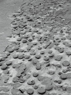
Beach biscuits is the informal name used for these flat, disc-shaped clots of sand that can be seen forming from a surface layer of darker, cohesive sand (upper left) as it is eroded by the wind. The semiresistant layer may be either salcrete or damp sand, in contrast to the lighter-color underlying sand, which is noncohesive and easily blown away by the wind. The biscuits then form resistant caps that contribute to pedestal formation.
The recipe for sand dunes requires only the addition of a sand-trapping mechanism at the back of the beach to the existing wind and sand mix. Healthy sandy beaches are a reservoir of sand for the formation of sand dunes, and beaches and dunes are commonly associated in the beach equilibrium model (see chapter 4). Vegetation becomes important as both a sand trapper and a sand binder in the formation of dunes, although significant coastal dune fields form along shores (with large sand supplies) lacking vegetation. In the latter areas, any obstacle (e.g., large wrack objects, rock outcrops) may be the reason dune formation begins, and even where such objects are absent, the wind cannot carry sand inland indefinitely. Simple friction will cause the wind velocity to decrease and the wind to drop its sediment load.
On the dry upper beach, the small embryonic dunes that form behind large pieces of flotsam or around clumps of vegetation will grow and coalesce into a dune (shadow dune), and such dunes in turn will join to form sand ridges, or foredunes (transverse dunes), at the back of the beach.
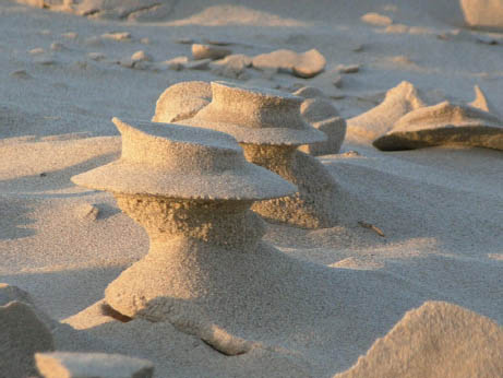
Pedestals form when a cohesive sand layer such as salerete, a biscuit, or a shell resists sand removal while the noncohesive underlying sand is eroded away. The resulting pedestals may resemble mushrooms, little hats, or sand columns capped by a shell, pebble, or small piece of drift material. These pedestals were found on the eastern shore of Lake Michigan. Photo courtesy of Larry Fegel.
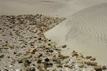
Coarse lag deposits are left behind as the wind selectively removes sand and finer sediment. Here on Mexico’s Baja peninsula, the lag consists of gravel and shells, and the adjacent dunes are well-sorted sand. The surfaces of the dunes are covered with wind ripple marks.
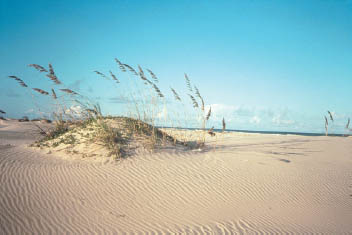
As the wind moves sand to the back of the beach, sea oats colonies take hold and trap sand into small embryonic dunes. The increased elevation of the dune allows a creeping vine to grow and trap more sand, which will contribute to increasing the size of the dune. Note the beautifully wind-rippled surface.
The pioneer plants that sprout on the upper beach are salt tolerant and can survive the daily salt spray as well as occasional tidal flooding by seawater. Many also fix nitrogen, or remove that gas from the air to produce the soil nutrient nitrate. Initial dune formation is enhanced by dune-grass colonization: Stands of this tall grass trap sand and anchor the deposit by putting down deep roots to the water table, as well as horizontal roots (rhizomes), which further anchor the sand. The laterally spreading rhizomes allow the plants to sprout shoots and spread rapidly over wide areas.
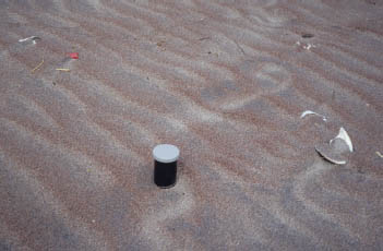
Wind ripple marks tend to be lower in amplitude than water-laid ripples, and the crests are not as sharp. These wind ripples on the back of a Bogue Banks, North Carolina, beach developed in a heavy-mineral sand, and the grains are sorted by differences in their weight or specific gravity, with the red wine–colored garnet on the steep faces, the black magnetite on the lee faces, and the light mineral quartz in the troughs. The 35 mm film canister is shown for scale.
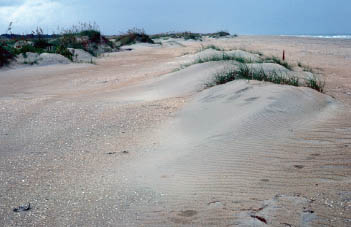
Three merging shadow dunes are in the foreground and a developing foredune is in the background. The importance of plants in trapping and stabilizing the dunes is apparent.
Dune grasses are most important in the early stages of foredune formation and in part determine the character of the dune. From a global view, three dune grasses are common; two species of marram grass (mare is Latin for “sea,” so marram grasses are seaside grasses)—European beach grass (Ammophila arenaria) and American beach grass (Ammophila breviligulata)—and sea oats (Uniola paniculata). European beach grass is native to Europe and northwest Africa, but early in the history of British colonization this grass was spread throughout the world as a planting to stabilize sand dunes and encourage dune growth. Similarly, American beach grass is native to northeastern North America’s Atlantic Coast and the Great Lakes, but the grass has been introduced to America’s Pacific Coast and other parts of the world. These artificial introductions of grasses have altered the character of dunes in these locales far beyond the natural range of the grasses, to the point that some communities are now trying to eradicate such plants and return shore habitats to the original native species. Sea oats is a grass native to the southeastern United States, Mexico, and the Caribbean. Artificial plantings of this grass also are used to stabilize dunes.
While these three grasses are dominant dune formers, there are numerous other plants important to coastal dune formation and evolution, too extensive to review here. However, in nearly every beach and dune system and associated barrens, as on barrier islands, alien species are not uncommon. Another example is the Asiatic sand sedge (Carex kobomugi), which is native to the Pacific Coast of Japan, Korea, China, and Russia, where it contributes to sand trapping and dune formation. The plant was used as packing material in earlier times and found its way to the New Jersey coast of North America by 1929. It was found to be a dune stabilizer, and artificial plantings of this species in the 1960s and 1970s spread to become a threat to native plants along the eastern seaboard of North America, particularly in New Jersey’s coastal dunes. Other species of this same genus, Carex, are found in coastal dunes of other parts of the world (e.g., Carex maritima in Great Britain; C. houghtoniana in Lake Ontario dunes; C. macrocephala along North Pacific shores).
Some beach and dune sands are sonorous; that is, they generate a unique sound when walked on, or, in the case of sand dunes, when winds blow over the dunes or the dune’s steep-side slip face avalanches and the sand flows down. High-pitched sounds generated by beach sands are described as singing, barking, squeaking, chirping, whistling, yelping, and even burping or the croaking of a frog. The low-frequency sounds generated by avalanching dune sands are termed booming, musical, roaring, or shouting, but the sound of approaching low-flying propeller-driven airplanes comes closest to describing the roar.
An extensive scientific literature has reported on the frequencies of the sounds, the locations, and the characteristics of the squeaking sands. Differences of opinion remain as to the exact causes of the sound, although it is generally attributed to the shear that occurs between sand grains when they rotate past each other on compression, or when one layer of sand grains slides over the underlying layer. Walking or shuffling on the dry beach will cause such shear, and on the Lake Superior beach at Bete Gris, Michigan, the sound can be produced by rotating the palm of one’s hand on the beach. Most singing sands will not sing once removed from the beach, yet others can be collected and placed in a beaker and will squeak when a pestle is pushed up and down in the sample (here again the sound is attributed to the effect of shearing between quartz grains).
Generally, squeaky sands are siliceous, dominated by the mineral quartz, have been subjected to wetting and then drying, and are at a low humidity. These sands are free of impurities and finer-grained material; adding dust or powder-size material to the sand will eliminate the sound, and grains with an organic coating lose their voice as well. The loss of sound production in some formerly squeaky beaches in Japan and Brazil is attributed to pollution. In other words, only “squeaky-clean” sands squeak. When naturally squeaky beaches are artificially nourished, they lose their sound characteristic.
Not too many years ago, the only way to experience such sand sounds was to visit a beach with the right characteristics and then to recognize what was happening when hearing such sounds. Today, one can find video recordings of the sounds posted on the Internet. Just Google “singing or squeaking sand” or go to YouTube and search for “musical sand dunes” and follow the various links. Squeaky Beach, in Victoria, Australia, seems to be the most popular posting, but similar sounds may be heard on Prince Edward Island, Canada, a North Sea beach in Holland, a beach in Phuket, Thailand, and South Island, New Zealand. Other famous singing beaches include Singing Beach at Manchester-by-the-Sea, Massachusetts, beach sands on the Isle of Eigg, Scotland, and beaches on the Freycinet Peninsula, Tasmania. Virtually every continent has singing beaches.
Of particular interest are the sand sounds described as “barking,” which can be heard on Barking Sands Beach, Kauai, in the Hawaiian Islands, and “whistling,” which can be heard on the sands on Porthoer Beach, Llyn Peninsula, North Wales. At least thirty-three beaches in Japan have been identified as having singing sands, and resorts with the name “Singing Sands” in places such as Placencia, Belize, and Eleuthera Island, Bahamas, imply that the beaches sing there too.
The low-pitched booming or roaring sounds associated with large dunes are found both in large coastal dunes and in large inland dune fields in arid deserts. The back-beach dunes near Mana, Kauai, Hawaii, are a good example, but other large coastal dunes likely to produce such sounds are found on the Chilean Pacific Coast and in West Africa and Australia. Marco Polo reported hearing booming dune sands in the deserts of China.
The spreading or invasion of European beach grass to the Oregon coast of the United States has created big changes in the appearance of coastal dunes and in the ecology of the beachfront zone. The native grass (Elymus mollis) produced low-lying dynamic dunes with overwash gaps. European beach grass created stable high dunes without gaps. The resulting cutoff of overwash sediment to areas behind the dunes created a new ecological system.
Because the marram grasses (European and American beach grasses) grow in dense stands and spread laterally in a more or less continuous pattern, the foredunes that result tend to be continuous ridges without natural breaks in the dune line. In contrast, sea oats tend to be patchy in their distribution, so where they control dune formation, the dune line is more hummocky, broken by topographic lows or swales that are natural pathways for the formation of overwash passes in storms. The same is true for arid environments, where the patchy cover of vegetation allows blowouts and breaches to form, particularly during storms. A beach with a continuous dune line at the back (typical of dunes formed by marram grasses) responds quite differently to storms than a hummocky, broken dune line (typical of dunes formed by sea oats).
The breaks funnel wind currents and may account for the natural formation of blowouts, bowl-shaped depressions eroded by the wind. Blowouts are the largest wind-formed erosional features in dunes. Those formed in temperate climates bottom out at the top of the groundwater table, forming a flat floor. Many of the blowouts in coastal dunes form as the result of dune destabilization by human activities such as paths from foot traffic to the beach, or vegetation kills from campfires. Countries such as the Netherlands and Denmark, which understand the importance of sand dunes as reservoirs for maintaining beaches, are strict about keeping the public off the dunes.
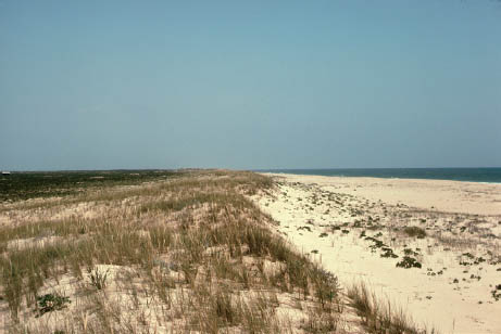
This foredune on Culatra Island, Portugal, in a semiarid environment, has only a sparse cover of dune grass and is subject to the formation of blowouts and breaches during storms, allowing washover to carry sand to the back side of the island. In arid regions or where sand supply is very high, the coastal dunes may be barren of vegetation and subject to rapid migration.
The eroded sides of blowouts often expose the natural internal structure of a sand dune, revealing the common dune cross bedding. As a sand dune grows, the sand grains are carried up the windward (back) side of the dune to the crest and then blow off into the leeward wind shadow and settle out through the quiet air; alternatively, they roll or slide down the steep leeward face of the dune. The result is that the dune face is burying sand layers, or laminae, that are inclined at angles as steep as the angle of repose of dry sand (about 30 degrees). This mode of sand movement is also how the dune migrates as an asymmetric landform. Random sections cut through the dunes will show the buried layers as cross beds at various degrees of inclination, up to 30 degrees. On the upper parts of sand dunes, where the wind has beveled off the dune and produced somewhat flattened surfaces, the exposed edges of these inclined layers also create curious patterns.
By their very nature, sand dunes tend to be unstable, cycling through deposition, erosion, and redeposition, and migration, stabilization, and destabilization. Most areas of coastal dunes have good examples of dunes migrating into or over the static structures of humans. Most coastal dunes in temperate climates are vegetated dunes and are irregular in shape. Where blowouts are common in foredunes, the resulting dune type is the parabolic dune, a scoop-shaped dune that is convex in the downwind direction. Such dunes form when sand supply is high or when vegetation is ineffective in trapping sand. A parabolic dune is a good place to look for dune migration features. Parabolic dune faces may show sand slump, slide, and flow features, and the landward side of the dune shows evidence of burial of vegetation or whatever is in its migratory path.
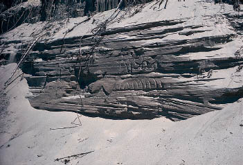
Erosional bluff faces cut in dunes at the back of the beach often expose cross beds. Layers in this exposure have cross bed sets that are inclined in different directions, reflecting variable wind directions. Such exposures usually do not persist, because of slumping and slope collapse.
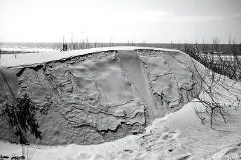
The slip face of a landward-migrating dune in a coastal dune field in the U.S. state of Georgia. The dune migrates as sand avalanches down the face by flowing (the tongue-shaped pattern) or by slumping or sliding (the sheet pattern), or as sand blows off the crest of the dune.
Like beaches, dunes are strongly influenced by sand supply. In some cases, dunes are very ephemeral, reflecting a relatively short-term event that led to dune formation but then ceased. A good example is when a tidal inlet closes. The offshore ebb delta in front of the inlet is a reservoir of sand. When the inlet closes, much of that sand may come ashore, feeding shoreline accretion and dune formation. Once the reservoir is exhausted and the offshore body of sand is gone, the pattern changes to shoreline retreat, and dune growth either ceases or is greatly reduced. However, where there is a healthy and continuous sand supply, great dune fields form. Some noteworthy examples include Coos Bay, Oregon, in the United States; the Brazilian Gurupi Coast, south of the Amazon; Britain’s Sefton Dunes; France’s Bay of Biscay coast and the Great Dune of Pilat, Europe’s largest sand dune; the dunes of the Curonian Spit in Lithuania; the Doñana National Park on the Gulf of Cadiz, Spain; in Africa, the Morocco Atlantic Coast, the Alexandria Coastal Dunefield, and the Namib Sand Sea of Namibia; in Asia, the Tottori dunes of Japan and Mui Ne in Vietnam; and in Australia, the Cronulla sand dunes near Sydney, Mount Tempest near Brisbane (Australia’s highest), and Fraser Island, Queensland.
The combination of high winds and blowing sand produces another interesting artifact of nature found both in deserts and coastal dune fields. Pebbles and cobbles exposed to the wind are sculpted by sandblasting to form smooth faces that intersect each other with sharp edges. If the pebble is partly buried, only the exposed portion will have the flat faces, while the buried portion remains rounded. Appropriately enough, these rocks are called ventifacts.
The next chapter (chapter 9) reviews some of the array of sedimentary structures that form from biological processes in dunes and beaches. In addition to wind ripples, the transition zone from the back of the dry beach into the toe of the dunes is characterized by animal traces, typically crab tracks and their burrow holes, as well as a variety of insect trails and burrow traces (e.g., from burrowing beetles, bees, and fly larvae). At the vegetation line, circular to semicircular scribe marks etch the sand surface where the tips of grass fronds, stalks, or fine rootlets have been dragged around by the wind. Patches of dune grass are favorite sites for ant lions to build their conical pits to trap other insects. Throughout the dune system, animal tracks, trails, and droppings can be identified. Bird footprints are the most common, but tracks of reptiles, rodents, and mammals are easily spotted on the bare sand surfaces.
Upper left Praia do Guincho, Portugal, is famous for its prevalent onshore winds and sand dunes that migrate inland from the beach. Limestone and gravel derived from local outcrops are sandblasted by these winds to form ventifacts and outcrops with sculpted faces. The camera lens cap is shown for scale.
Lower left Scribe marks produced by the ends of dune grass fronds moved back and forth by the wind. Note also the opening of a hole produced by an unknown dune burrower.
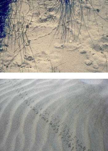
Upper right Extensive burrow traces reflecting activity just below the surface of a dune. Different-size burrows indicate different organisms, but beetles and bees are suspects here. The U.S. nickel is shown for scale.
Lower right A trail of reptilian footprints across a wind-rippled dune surface near Colan, Peru.
The sand dunes behind a beach are a relatively arid environment even in moist climates. Pour a cup of water into dune sand; where does it go? The answer is down, all the way until it reaches an impermeable layer such as a salt marsh peat, another impermeable deposit, or the water table. When the dunes are 100 ft (30 m) high, the plants on top of the dune crest have to go down deep to get water. Because the adaptation to produce deep roots is not common, very few plant species can survive in a sand dune field. Those that do survive have deep, water-gathering root systems.
Beaches and dunes are the last places you want to be in an electrical storm. Most beach-safety lists stress water and sun hazards, but they rarely stress getting off the beach and dunes before a storm arrives. Lightning strikes on beaches are common, and fulgurites are reminders of past strikes and their intensity. Sometimes called petrified lightning, fulgurites are tubular structures of natural glass that form when silica-rich sand (e.g., quartz, feldspar) is melted by the intense heat (3,270°F [1, 800°C] or greater) generated by a lightning strike. The sand melts and immediately chills to glass, and sand grains fuse to the surface of the melted sand. Although fulgurites up to 49 ft (15 m) long and several centimeters in diameter have been reported, the resulting tubular structure is usually a fairly small, glassy tube a few inches long, with a rough, irregular outer surface. The tubes are sometimes curved, rather than straight, and may branch. Similar structures can form where high-voltage electrical lines come in contact with siliceous sand, as when lines break during storms. Again, this is not a place you want to be when a fulgurite might form.
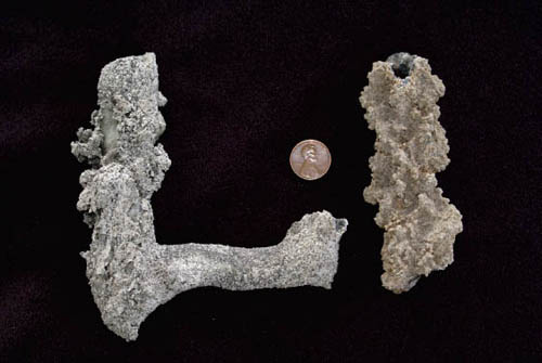
Two fragments of fulgurites showing fused sand and the characteristic hollow-tube structure. Cemented sediment fill of burrows sometimes is mistaken for fulgurites; the best way to avoid this error is to confirm that the fulgurite has glass lining the tube (at the top of the sample on the right and in the patch exposed on the upper left side of the sample on the left). The U.S. penny is shown for scale.
Collectors who seek fulgurites are most likely to find them in dunes, including those in noncoastal deserts. Cemented burrow-fill sediments are sometimes mistaken for fulgurites because of their shape, but the genuine article can be identified by the appearance of glass: smooth, translucent, and often containing small bubbles. The color ranges from dark grays to green to tan or almost colorless, depending on the initial composition of the sand.
Coastal dune plants also must tolerate salt spray and a limited supply of nutrients. Try spraying your garden plants with salt once or twice a week and not providing them with food (i.e., use dry sand instead of mulch or potting soil). Your garden would soon be barren, but dune plants are tough and have developed special adaptations to survive in the harsh coastal environment.
Everyone thinks of a cactus as a desert plant, and its defining characteristics are its needles. These are the cactus’s leaves. Nature has bundled them up into sharp needles to reduce their surface area because plants give water back to the atmosphere, or transpire, at a rate proportional to the area of their leaves. There are cacti in dunes (e.g., prickly pear) for the same reason. Other dune plants simply roll up their leaves to conserve water during the hottest part of the day. In another strategy, dune plants store water to survive droughts. These succulent plants are common in deserts as well as in coastal dunes. Finally, another mechanism for dune plants to retain what little water they get is to cover their leaves and fruit with a waxy coating. The wax coating on such plants as bayberry (Myrica sp., used to make candles) reduces evaporation, and the ability of the roots to fix nitrogen allows the plants to live in poor soils.
A walk on a path through the dunes as you leave the beach presents a fascinating series of botanical changes that are driven by plants’ differing abilities to survive in the coastal desert. On the edge of the sea, dune colonizers fix nitrogen and, along with occasional pieces of seaweed, create a rudimentary soil. These colonizers are replaced in a landward direction by dune grasses, usually a monoculture (a single plant species) that sometimes extends over a vast area. Connected by horizontal roots, or rhizomes, single living plants cover extensive areas of these dunes. This characteristic was once discovered in the U.S. state of New Jersey when an herbicide was sprayed on a small area of dunes but killed the plants beyond the spray zone. These dune plants reproduce for the most part vegetatively, that is, by having new shoots grow up from rhizomes. The advantage of this type of reproduction is that it would be a waste of energy for the frontal plant to go to flower and seed because the plants grow so densely and soil conditions are so poor that a seed would not have much of a chance for germination success. Look closely in July or August at the marram grasses and note where the plants have flowering or seed heads. They flower only at edges of the dune field, where windblown sand partly covers their stems. In fact, that is the triggering mechanism for flowering in marram grasses. When sand is free to blow, there are not many other plants around (the nearby areas are bare beach or a pathway), and it is worth the plants’ effort to produce seed.
In the more landward reaches of a dune field, shrubs appear, such as seaside roses and bayberries in eastern North America. These plants need a more stable, nutrient-rich soil than the marram grasses. Marram grass is so adapted to surviving in its seaside location that it cannot outcompete even the most common weeds in a terrestrial field (any more than field weeds could ever survive in a sand dune environment). Shrubs cannot endure salt spray like marram grasses either, and so they appear only in more landward locations. Even in a more landward position, shrubs and trees are subject to the effect of the salty sea spray that is released from the bursting bubbles of breaking waves. The salt air prevents the formation of new leaves and branches on the seaward side of the vegetation zones closest to the shore, resulting in salt pruning, the characteristic sloping of the vegetation profile from the crown of the maritime forest down across the shrub line to the dune meadows.
In the most landward positions, the climax or ultimate sand dune plant community, the maritime forest, is found. Trees vary globally, but stunted evergreens such as pitch pines are common, as are oak, cedar, holly, and other pine, as well as a unique undergrowth community.
This change from one plant community, specially adapted to its place in the dunes, to another is called botanical succession, each group of plants succeeding the previous group. As a beach grows seaward, the pioneer plants at the back of the beach are followed by marram grasses, which are followed, or succeeded, by shrubs and then by the maritime forest. Each community prepares the way for the next, and the process leading to a maritime forest can take, literally, hundreds to thousands of years.
What does it mean, then, when we observe a maritime forest at the edge of the beach, with its trees falling into the sea? The answer is either natural or man-made change. One scenario is that the beach grew seaward during a time of slowly rising sea level and the plant-succession zones developed, leading to a maritime forest some distance in from the shore, but the rate of sea-level rise now has increased, and rapid shoreline erosion has allowed the migrating beach to erase the dunes and cut directly into the forest. Alternatively, perhaps the abundant sand supply that helped maintain a healthy dune system has been cut off by engineering structures to protect buildings, and the lack of sand supply contributed to dune loss and beach retreat into the maritime forest.