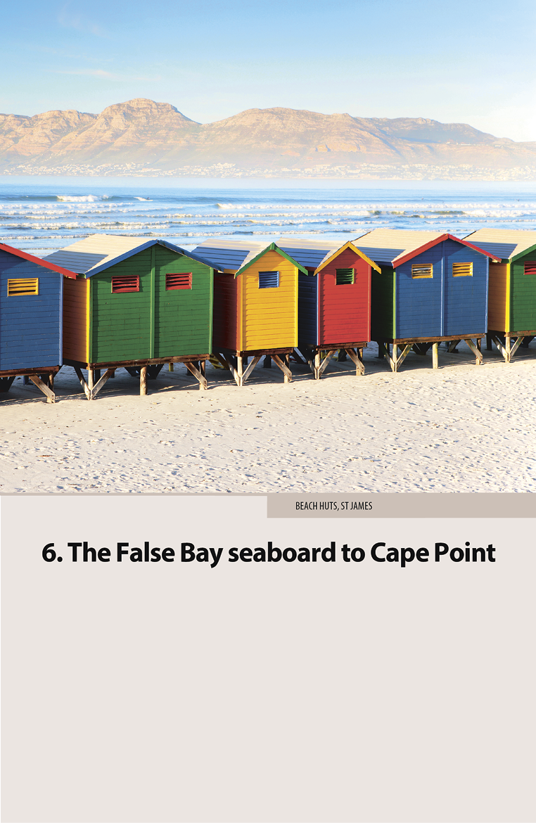
The False Bay seaboard to Cape Point
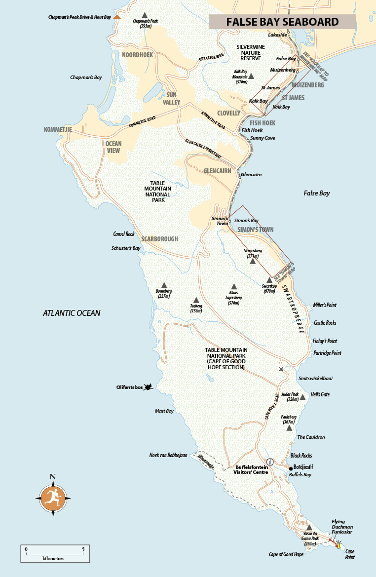
In summer, the waters of False Bay are several degrees warmer than those on the Atlantic seaboard, which is why Cape Town’s oldest and most popular seaside towns line this flank of the peninsula. From Muizenberg down to Simon’s Town via St James, Kalk Bay and Fish Hoek, this series of historic suburbs strung between mountain and beach are served by Metrorail stations. The train ride is reason enough to visit, and from Muizenberg most stations are situated close to the surf. Each suburb has its own character and places to eat, drink and sleep, while Simon’s Town, one of South Africa’s oldest settlements, makes either a pleasant day-trip or a relaxing base for visiting the penguins at Boulders Beach, just south of town, and Cape Point itself. This may be the peninsula’s less moneyed coastline, but it is no less beautiful with Cape Point as its dramatic finale.
Arrival and departure: False Bay Seaboard
By car Driving here from central Cape Town, the best route is along the M3 south to Muizenberg. Boyes Drive, a high-level alternative to coastal Main Rd, runs for about 7km between the suburbs of Lakeside at the southern end of the M3 and Kalk Bay, and offers spectacular views across to the Hottentots Holland Mountains on the east side of False Bay. The road is also one of several spots on the Cape Peninsula where, at the right time of year, you might spot whales.
By train On Metrorail’s safe and popular Southern Line from Cape Town to Simon’s Town, there are roughly three trains an hour from Monday to Friday (5.10am–9.15pm; 1hr 15min; R16.50) and four as far as Fish Hoek (58min; R13.50). Trains travel via Muizenberg (48min; R13.50), St James (51min; R13.50) and Kalk Bay (55min; R13.50); on Saturday and Sunday, services are reduced to roughly one an hour from Cape Town to Simon’s Town. Travel in MetroPlus (nominal first class) and stick to daylight hours, departing between about 7am and 6pm, for safety. The trains fill up heading into the city on weekday mornings before 9am, and leaving town on weekday afternoons after 4pm. Metrorail (![]() 021 449 6478,
021 449 6478, ![]() metrorail.co.za,
metrorail.co.za, ![]() cttrains.co.za) provides telephonic timetable information, and downloadable PDFs are available from their website.
cttrains.co.za) provides telephonic timetable information, and downloadable PDFs are available from their website.
Muizenberg
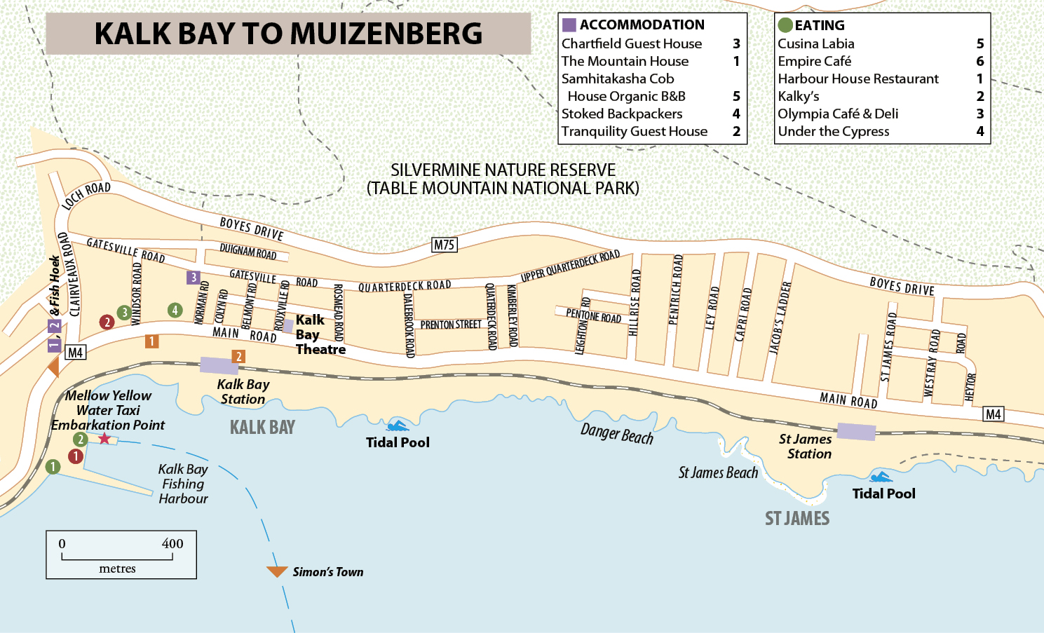
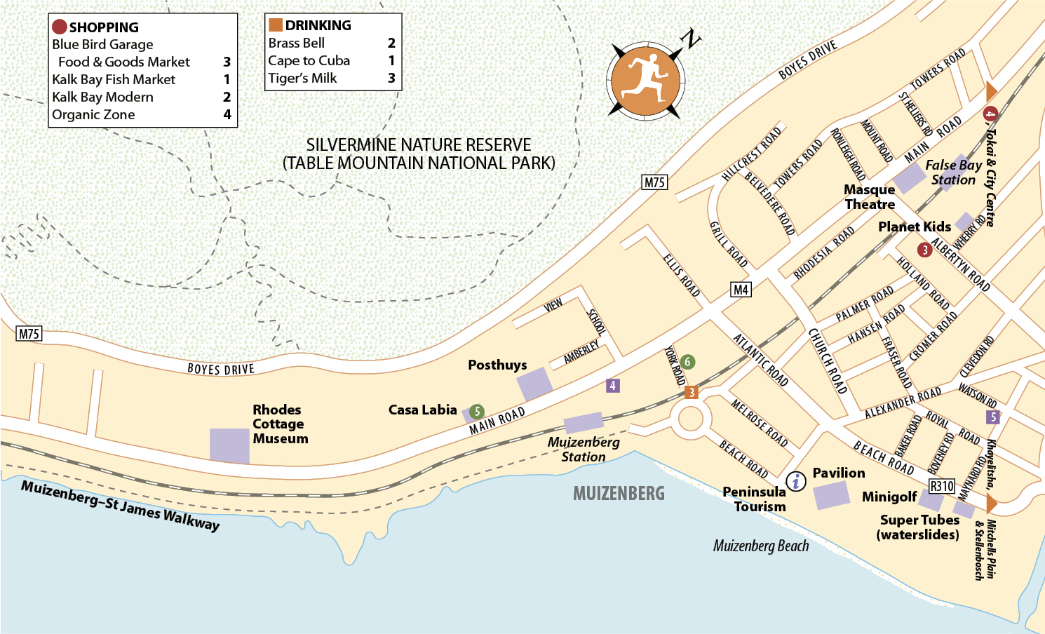
Once boasting South Africa’s most fashionable beachfront, Muizenberg (pronounced “mew-zin-burg”), 27km from the city centre, is rising from the doldrums with the beautification of its seafront, where cafés, restaurants and bars overlook the sand. On its long, safe and fabulous beach, the brightly coloured Victorian bathing chalets are cheerful reminders of a more elegant heyday. During the 1920s, it was visited by the likes of crime novelist Agatha Christie, who learnt to surf – and wipe out – here. “One soon got the knack of coming in on the waves,” she wrote. Today, the water is invariably bobbing with dozens of surfers; you can hire boards and organise lessons at the surf shops on Beach Road.
The beach
Muizenberg Water Slides mid-Sept to April Mon–Fri 1.30–5.30pm, Sat & Sun 9.30am–5.30pm; night slide Fri 6–9pm • R45 per hr, R85 per day • ![]() 021 788 4759,
021 788 4759, ![]() muizenbergslides.co.za
muizenbergslides.co.za
Muizenberg’s gently shelving, sandy beach is the most popular stretch of sand along the peninsula for swimming, especially on Sundays in summer, though note that it can be windy.
At the eastern end of the esplanade, a water park with a trio of slides keeps kids well occupied. Muizenberg’s shabby-chic hinterland is also worth a wander, frequented by the local artistic fraternity as well as a Congolese community.
Beach safety tips
Don’t take anything valuable to the beach, and don’t leave anything unguarded while you’re there, as opportunist theft is rife. Guards are present at the car park, so preferably leave valuables in your car boot – and place them there discreetly. False Bay is also home to great white sharks, and you will notice shark flags raised and a siren calling surfers and bathers out of the water when a shark is spotted.
Historical Mile
A short stretch of the shore, stretching south from Muizenberg Station, is known as the Historical Mile, dotted with notable buildings and easily explored on foot. The train station, a late Edwardian-style edifice completed in 1913, is now a National Monument, while the nearby Posthuys was once a lookout for ships entering the bay. A rugged whitewashed and thatched building dating from circa 1673, it is a fine example of the Cape vernacular style.
Casa Labia
192 Main Rd • Tues–Sun 10am–4pm • Free • ![]() 021 788 6068,
021 788 6068, ![]() casalabia.co.za
casalabia.co.za
The most idiosyncratic of the buildings along the Historical Mile, Casa Labia was completed in 1930 as the residence of the Italian consul, Count Natale Labia. Built in eighteenth-century Venetian style, it’s a glorious piece of architectural bling on Main Road and worth popping into just for the palazzo’s film-set interiors. It also houses a cultural centre that puts on concerts and talks, a gallery of modern and contemporary South African art, an opulently furnished café and a craft shop.
Rhodes Cottage Museum
246 Main Rd • Mon–Sat 10am–2pm • Admission by donation • ![]() 021 788 1816,
021 788 1816, ![]() facebook.com/RhodesCottageMuseum
facebook.com/RhodesCottageMuseum
Controversial British mining magnate, politician and empire builder Cecil Rhodes bought this modest cottage in 1899, as a recuperative seaside retreat. His plan was to spend time here while his more monumental pile, Rust en Vrede (closed to the public), was being built next door. He died at the cottage in 1902, before the house was completed.
Manned by knowledgeable volunteers, the Rhodes Cottage Museum contains memorabilia which paints a (somewhat rosy) portrait of the infamous colonialist. Among the photographs are a model of the Big Hole in Kimberley in the Northern Cape, where Rhodes made his fortune at the diamond diggings, and a curious diorama of World’s View in Zimbabwe’s Matopos Hills, where he was buried. The lovely fynbos garden straggles up the mountainside.
The Cape Dutch Revival
During the 1890s, millionaire tycoons such as British expatriate Cecil Rhodes found themselves at the top of the South African pecking order. These men saw themselves as an Anglo-African aristocracy lording it over the country, much as the landed gentry did back in Britain. The Randlords, as Johannesburg’s mining magnates were known, and characters like Rhodes in the Cape were among the biggest patrons of architecture, as they sought to express their new power and status.
Rhodes commissioned Herbert Baker, a young English architect schooled in the British Arts and Crafts Movement, to rebuild Groote Schuur following a fire in 1896. The grand mansion on Klipper Road in Rondebosch is now South Africa’s official presidential residence. Looking for inspiration, Baker identified Cape Dutch architecture as a suitable model – it was old and it represented wealth, making it the closest local equivalent to the stately homes of England.
Baker used recognizable Cape elements such as gables, curving multi-paned windows and steeply pitched roofs. He also drew on English traditions, such as barley-sugar chimneys that hark back to Tudor architecture, while bird figures that Rhodes removed from Great Zimbabwe were used to suggest the gargoyles of Gothic architecture.
This style came to be known as Cape Dutch Revival, and was used again by the architect at Rust en Vrede (1902), Rhodes’ seaside residence, adjacent to Muizenberg’s Rhodes Cottage Museum (see above). The Cape Dutch Revival has become well established in South African architectural parlance: the twentieth century saw the appearance of Cape Dutch features, particularly gables, in suburban houses, no matter how inappropriate the scale or context.
St James
St James, 2km south of Muizenberg, is more upmarket than its neighbour, with its mountainside homes reached up long stairways between Main Road and Boyes Drive. The best reason to hop off the train here is for the sheltered tidal pool, overlooked by more multicoloured bathing chalets, and the twenty-minute walk to Muizenberg on the paved coastal path. Running along the rocky shore, it is one of the peninsula’s easiest and most rewarding walks, with panoramas of the full sweep of False Bay. Look out for seals, and in season, whales.
The beach
The compact St James beach draws considerable character from its much-photographed Victorian-style huts, whose bright, primary colours catch your eye as you pass by on the road or by rail. The beach tends to be overcrowded at weekends and during school holidays; far fewer visitors stroll south on the short footpath to the adjacent sandy stretch of Danger Beach, an excellent spot for sunbathing and building sand-castles. As the name suggests, its surf should be treated with respect, as there is a powerful undertow here.
Whale spotting on the False Bay seaboard
The most common whales you’ll see off the Cape are southern rights, and the warmer False Bay side of the peninsula has the best whale-watching spots in season (roughly June–Nov). There is some chance of spotting them on the Atlantic seaboard, too; whichever coastline you’re visiting, you should have binoculars handy. The months when you are more or less guaranteed sightings are September and October.
Boyes Drive, which runs along the mountainside above Muizenberg, St James and Kalk Bay, provides an outstanding vantage point. To get here by car, take the M3 from the city centre to Muizenberg; at Lakeside, look for the sharp, signposted right turn into Boyes Drive. The road climbs from here, descending finally to join Main Road in Kalk Bay.
Alternatively, if you stick close to the shore along Main Road, the stretch between Fish Hoek and Simon’s Town is recommended, with a nice spot above the rocks at the south end of Fish Hoek Beach, as you walk south towards Glencairn. As well as penguins, Boulders Beach has a whale signboard and smooth rocky outcrops above the sea to sit on and gaze across the water. Further south, you might also spot them in Miller’s Point, Smitswinkelbaai and the Cape of Good Hope Nature Reserve.
Without a car, you can catch the train to Fish Hoek or Sunny Cove and whale-spot from the Jager’s Walk beach path, which follows the coast between the two, just below the train line.
It’s worth noting that there are more spectacular spotting opportunities further east, especially around Hermanus and De Hoop.
Although False Bay is great for land-based whale watching, on a boat you get a different perspective: you’re in the gargantuan marine mammals’ own element and you may just get a closer look. There are also opportunities to spot other whales such as Bryde’s, humpbacks and orcas, and other marine animals including dolphins and seals (both visible all year). Simon’s Town Boat Company (![]() 083 257 7760,
083 257 7760, ![]() boatcompany.co.za), based at the Simon’s Town pier, offers boat-based False Bay whale-watching trips (daily 10.30am & 2pm; adults R900, children under 12 R600). They also run cruises around Cape Point (adults R600, children under 12 R500) and to Seal Island (adults R450, children under 12 R350).
boatcompany.co.za), based at the Simon’s Town pier, offers boat-based False Bay whale-watching trips (daily 10.30am & 2pm; adults R900, children under 12 R600). They also run cruises around Cape Point (adults R600, children under 12 R500) and to Seal Island (adults R450, children under 12 R350).
Kalk Bay
One of Cape Town’s smallest and most southerly suburbs, Kalk Bay centres around a lively working harbour with wooden fishing vessels, mountain views and a strip of shops brimming with collectables, antiques dealers and plenty of places to eat and drink. Uniquely, Kalk Bay managed to resist the Group Areas Act, making it one of the few places on the peninsula with an intact coloured community. As well as coloured fishermen, the 275-year-old settlement is home to numerous artists and creative types, who thrive on Kalk Bay’s village atmosphere and natural beauty.
The settlement is arranged around the small harbour, one of South Africa’s oldest, where you can watch the boats come in. You can also buy fresh fish, which are flung onto the quayside and sold in a spirited fashion, though stocks are declining and fishing folk increasingly have to battle for permits. The harbour and seafront are busiest over weekends, when Capetonians descend to pick up something for the braai or to have lunch at the terrifically located restaurants, some within spitting distance of the breakers.
Mellow Yellow Water Taxi runs an hourly service between Kalk Bay Harbour and Simon’s Town.
Silvermine Nature Reserve
Ou Kaapse Weg • Daily: May–Aug 8am–5pm; Sept–April 7am–6pm • R50 • ![]() 021 701 8692
021 701 8692
Part of the Table Mountain National Park, the stunning Silvermine Nature Reserve rises behind Boyes Drive and stretches west across the peninsula’s spine, almost to Chapman’s Peak. The walks here in the Table Mountain chain of peaks provide fabulous views of False Bay, the mountains and montane fynbos, and you can picnic next to the idyllic Silvermine Dam.
It’s possible to get into the eastern half of the reserve for free via paths that strike up from Boyes Drive, including a set of stairs in Kalk Bay that climbs from Boyes just as it turns to the harbour. The climb is worth it for the superb views of the ocean.
The Silvermine Dam area is the starting point for many of the reserve’s best walks. To get here by car, take Ou Kaapse Weg (the M64 to Noordhoek), signposted at the southern end of the M3. The entrance is at the top of the tortuous mountain pass on the right-hand side. The road from the entrance gate leads through areas of fynbos to Silvermine Dam, where you can swim and picnic on the shore.
Alternatively, you can park at the entrance gate and do the easy and rewarding ninety-minute River Walk to the dam, which has no steep gradients, is well shaded and offers protection from the wind in summer. The other popular walk, which starts from the car park at the dam and offers sweeping views, is the two-and-a-half-hour climb up the Constantiaberg to Elephant’s Eye Cave. Both walks are signposted.
Slingsby’s excellent Silvermine & Hout Bay map, with hiking trails marked, is available at outdoor shops such as Cape Union Mart (![]() capeunionmart.co.za), which has branches at the Waterfront and the Gardens Centre, Cavendish Square, Constantia Village and Blue Route malls. Otherwise, the reserve’s brochure, which is dispensed at the gate and can be downloaded from the SAN Parks website, features a sketchy map.
capeunionmart.co.za), which has branches at the Waterfront and the Gardens Centre, Cavendish Square, Constantia Village and Blue Route malls. Otherwise, the reserve’s brochure, which is dispensed at the gate and can be downloaded from the SAN Parks website, features a sketchy map.

ZOOM LEFT
ZOOM RIGHT
Fish Hoek
Fish Hoek boasts one of the peninsula’s finest family beaches along the False Bay coast. The best and safest swimming is at its southern end, where the surf is moderately warm, tame and much enjoyed by boogie boarders. Thanks to the beach, there’s a fair amount of accommodation, but this is otherwise one of the dreariest suburbs along the False Bay coast. An obscure by-law banning the sale of alcohol in supermarkets or bottle stores has cast Fish Hoek as the peninsula puritan, but liquor is now available in bars and restaurants.
Facilities include a playground, changing rooms, toilets, drinking water and the beachfront Galley Restaurant. From the restaurant, a picturesque pathway, Jager’s Walk, provides a good vantage point for seeing whales. It skirts the rocky shoreline above the sea for 1km to Sunny Cove, from where it continues for 6km as an unpaved track to Simon’s Town.
Simon’s Town and around
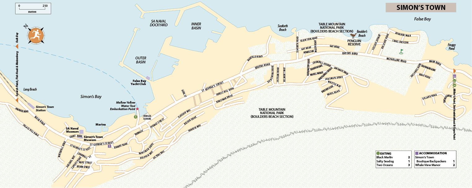
Just 40km from Cape Town, roughly halfway down the peninsula to Cape Point, Simon’s Town makes the perfect base for a mellow seaside break with good city access on Metrorail’s Southern Line. Despite being the South African Navy’s headquarters, having been a British Royal Navy base, Simon’s Town isn’t a hard-drinking port town. Rather, its well-preserved streetscape remains exceptionally pretty, bearing testament to its history as one of the country’s oldest European settlements. The domineering naval dockyard mars the aesthetics, but this – and glimpses of naval squaddies square-bashing behind high walls or strolling to the station in their crisp white uniforms – adds to Simon’s Town’s distinct nautical flavour. A few kilometres to the south is the rock-strewn Boulders Beach, with its colony of nonchalant African penguins – reason enough to venture here.
Brief history
The Dutch East India Company founded Simon’s Town in 1687 as their winter anchorage, and it became one of several places modestly named by Governor Simon van der Stel – after himself. Its most celebrated visitor was Lord Nelson, who convalesced here in 1776, as a midshipman en route home from the East Indies. Nineteen years later, the British sailed into Simon’s Town and occupied it as a bridgehead for their first invasion and occupation of the Cape. They left after just seven years, but returned in 1806, and Simon’s Town became a British base until 1957, when it was handed over to South Africa.
There are fleeting hints, such as the two mosques at the eastern end of Thomas Street, that the town’s predominantly white appearance isn’t the whole story. In fact, the first Muslims arrived from the East Indies in the early eighteenth century, imported as slaves to build the Dutch naval base. After the British banned the slave trade in 1807, ships were compelled to disgorge their human cargo at Simon’s Town, where one district became known as Black Town.
In 1967, when Simon’s Town was declared a White Group Area, there were 1200 well-established coloured families living here descended from these slaves. By the early 1970s, the majority had been forcibly removed under the Group Areas Act to the township of Ocean View, whose inspiring name belies its desolation.
ZOOM LEFT
ZOOM Right
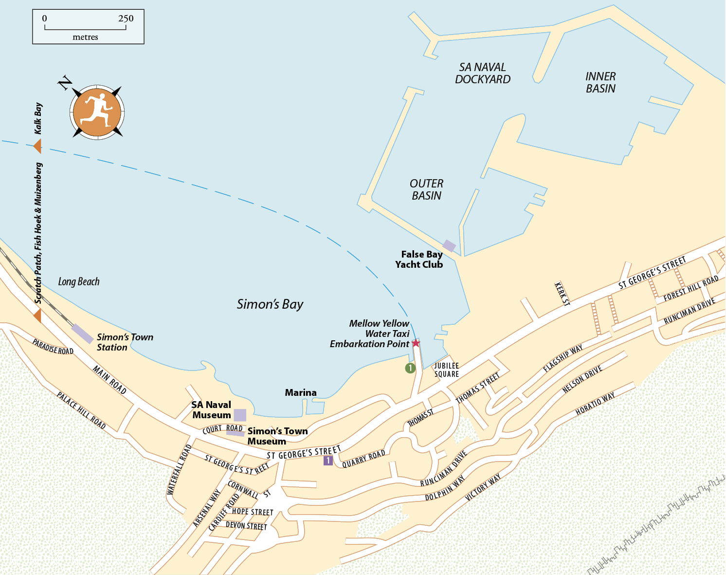
Simon’s Town Museum
Court Rd • Mon–Fri 10am–4pm, Sat 10am–1pm • R10 • ![]() 021 786 3046,
021 786 3046, ![]() simonstown.com/museum/stm.htm
simonstown.com/museum/stm.htm
The town museum occupies the Old Residency, built in 1777 as the winter residence of the Governor of the Dutch East India Company, whose slave quarters (later a jail) can be seen in the basement. The museum’s motley collection ranges from maritime exhibits and militaria to a whole room covering Able Seaman Just Nuisance, a much-celebrated Great Dane. He enjoyed drinking beer with the sailors he accompanied into Cape Town, and was adopted as a mascot by the Royal Navy in World War II, making Just Nuisance the only dog ever to have been enlisted in the Royal Navy.
The building also reputedly houses the ghost of Eleanor, the 14-year-old daughter of Cape governor Earl Macartney, who lived here in the closing years of the eighteenth century. Forbidden by her parents from playing on the sands with the children of coloured fishermen, Eleanor would escape to the beach through a secret tunnel she had discovered. The dankness of the tunnel supposedly gave her pneumonia, from which she tragically died.
South African Naval Museum
West Dockyard, accessed from St George’s St • Daily 9.30am–3.30pm • Free • ![]() 021 787 4686,
021 787 4686, ![]() simonstown.com/navalmuseum/index.htm
simonstown.com/navalmuseum/index.htm
The shipshape South African Naval Museum’s lively displays include the inside of a submarine, a ship’s bridge that simulates rocking, and numerous official portraits of South African naval commanders from 1922 to the present. Although much altered now, the museum occupies a mid-eighteenth-century Dutch East India Company magazine and storehouse, which was taken over by the Royal Navy when it installed its headquarters in Simon’s Town in 1810. Ask about taking a guided tour of the SAS Assegaai submarine (![]() navy.mil.za/museum_submarine), which served thirty years in the South African Navy and closed for repairs in 2015.
navy.mil.za/museum_submarine), which served thirty years in the South African Navy and closed for repairs in 2015.
Jubilee Square and the Marina
In the centre of Simon’s Town, a little over 1km south of the station, lies Jubilee Square, a palm-shaded car park just off St George’s Street. Flanked by some cafés and shops, the square has on its harbour-facing side a broad walkway with a statue of the ubiquitous Just Nuisance and stalls selling curios. In summer, a community food and craft market takes place here between 9.30am and 3pm on the second Saturday of the month.
A couple of sets of stairs lead down to the Marina, a modest development of shops and restaurants set right on the waterfront. This is a popular and scenic lunch stop, with the best fish and chips to be had at the Salty Seadog.
Seaforth Beach
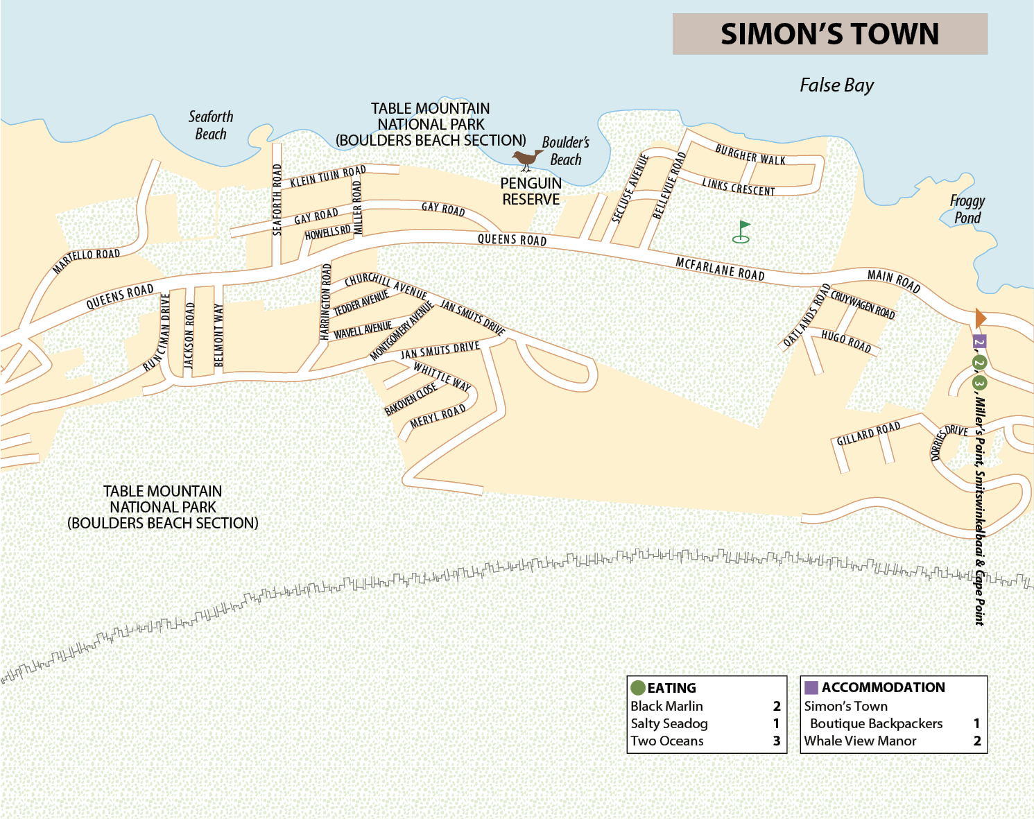
Seaforth Beach is the free version of the Boulders penguin reserve, with many waddling visitors from the colony at neighbouring Boulders, especially in early morning and evening. The northern access point and car park for Boulders are also here. Seaforth is one of the best local beaches for swimming, with clear, deep waters lapping around rocks. It’s calm, protected and safe, if not terribly pretty, being bounded on one side by the looming grey mass of the naval base. It does however have plenty of lawn shaded by palm trees, and a restaurant with outdoor seating and fresh fish on the menu.
Boulders Beach
Daily: Jan & Dec 7am–7.30pm; Feb, March, Oct & Nov 8am–6.30pm; April–Sept 8am–5pm • Adult R70, child R35 • ![]() 021 786 2329,
021 786 2329, ![]() sanparks.org
sanparks.org
Boulders Beach, Simon’s Town most popular beach, takes its name from the huge rounded rocks that create a cluster of little coves with sandy beaches and clear, cold sea pools, which make for wonderful swimming. However, most people come to walk the boardwalks and see the colony of two thousand or more African penguins in the Boulders section of the Table Mountain National Park.
Also known as jackass penguins for their distinctive bray, African penguins usually live on islands off the Southern African coast, including Robben Island. The Boulders birds form one of only two mainland colonies, with the second 100km east in Betty’s Bay. The reserve offers a rare opportunity to get a close look – and to hear that bray at its loudest, during the breeding season from March to May. Don’t touch or feed the penguins, for they may look cute and cuddly but their beaks are razor sharp; if they feel threatened they have no qualms about nipping the odd finger or nose.

from top left kalk bay; surf lesson, muizenberg; sunset, false bay; penguins, boulders beach
You can access Boulders from the signposted car park at Seaforth, 2km east of Jubilee Square, or, further on, from the car park on the reserve’s southern side, at the bottom of Bellevue Road.
Miller’s Point
About 5km south of Simon’s Town, this state-run resort and caravan park has a string of small sandy beaches and a tidal pool protected from the southeaster. Along Main Road, the Black Marlin restaurant attracts busloads of tourists, while the boulders around the point attract southern rock agama lizards, black zonure lizards and dassies.
Smitswinkelbaai
Heading south from Simon’s Town, the last place you come to before the Cape of Good Hope Nature Reserve’s gates is Smitswinkelbaai (pronounced “smits-vin-cull-buy”). This little cove has a small beach that is safe for swimming, but feels the full blast of the southeasterly wind. It’s not accessible by car; to get here, you must park in the layby and walk down the steep path.
Shark Country
False Bay is one of the best places in the country to encounter great white sharks. For one thing, the bay’s sharks are on average about a third bigger than their counterparts in Gansbaai (near Hermanus), the main centre of the shark-cage diving industry.
Apex Shark Expeditions (Quayside Building, Main Rd; ![]() 021 786 5717,
021 786 5717, ![]() apexpredators.com) is operated by naturalists Chris and Monique Fallows, who have worked with National Geographic and the BBC. They operate a range of marine trips in False Bay, among them shark-cage diving. Their emphasis is on observing shark behaviour – and that of other marine creatures you’ll encounter on the trip out to Seal Island – rather than the adrenaline rush. Trips are in groups of a maximum twelve people, which means you have a personalized experience and everyone gets a good stint in the cage.
apexpredators.com) is operated by naturalists Chris and Monique Fallows, who have worked with National Geographic and the BBC. They operate a range of marine trips in False Bay, among them shark-cage diving. Their emphasis is on observing shark behaviour – and that of other marine creatures you’ll encounter on the trip out to Seal Island – rather than the adrenaline rush. Trips are in groups of a maximum twelve people, which means you have a personalized experience and everyone gets a good stint in the cage.
Trips leave from the pier in Simon’s Town between February and September, and last three to four hours. Prices start at R2400 per person, and vary according to season (and the corresponding likelihood of encountering a shark).
arrival and departure: Simon’s Town AND AROUND
By train If you’re travelling by train to Simon’s Town, you can arrange to be collected by HGTS Tours, who act as a taxi service and have an office on the station platform (![]() 021 786 5243,
021 786 5243, ![]() hgtravel.co.za). A one-way trip to Boulders costs R30; an excursion to Cape Point, giving you 1hr 30min at the lighthouses and returning you to Simon’s Town station at the end, is R500 excluding entry fees. Book ahead, especially for the latter tour.
hgtravel.co.za). A one-way trip to Boulders costs R30; an excursion to Cape Point, giving you 1hr 30min at the lighthouses and returning you to Simon’s Town station at the end, is R500 excluding entry fees. Book ahead, especially for the latter tour.
Kalk Bay–Simon’s Town water taxi Mellow Yellow Water Taxi runs an hourly service between Kalk Bay Harbour and Simon’s Town public jetty at the marina (daily 9am–4pm, on the hour from Simon’s Town, half past the hour from Kalk Bay; R100 one-way, R150 return; ![]() 073 473 7684,
073 473 7684, ![]() watertaxi.co.za). Although tickets can be bought on the boat, it’s best to book ahead as the vessel takes a maximum of ten passengers and services are subject to the weather and whales crossing. The trip is highly recommended, and one of the few ways to get on the water in False Bay.
watertaxi.co.za). Although tickets can be bought on the boat, it’s best to book ahead as the vessel takes a maximum of ten passengers and services are subject to the weather and whales crossing. The trip is highly recommended, and one of the few ways to get on the water in False Bay.
Cape of Good Hope Nature Reserve
Cape Point Rd • Daily: April–Sept 7am–5pm; Oct–March 6am–6pm • Adult R135, child R70 • ![]() 021 780 9010,
021 780 9010, ![]() capepoint.co.za
capepoint.co.za
Many people visit the Cape of Good Hope Nature Reserve, which is part of Table Mountain National Park, to see the southernmost tip of Africa and the place where the Indian and Atlantic oceans meet at Cape Point. In fact, this is the site of neither: the continent’s real tip is at Cape Agulhas, some 300km southeast of here. Cape Point is Africa’s southwestern-most point, as well as being an awesomely dramatic spot and handily located compared with Cape Agulhas. You can also console yourself that the balmy Agulhas Current, which follows the Indian Ocean coast from Mozambique, meets the chilly Benguela Current, which heads up the Atlantic coast, on this stretch of coastline.
The 7750-hectare reserve sits atop massive sea cliffs with views, strong seas, and a wild wind which whips off caps and sunglasses as visitors gaze southwards from the old lighthouse buttress. European explorers called the headland the Cape of Storms for its treacherous weather; its ferocity also explains False Bay’s name, given by mariners who confused it with Table Bay and realised they still had to round the stormy peninsula. The altogether sunnier title, Cape of Good Hope, came after Vasco Da Gama made it past in 1497, opening up a new trade route from Europe to India and the Far East.
If you don’t bring food, you can take in the view while you eat at Two Oceans.
Flora, fauna and furry felons
The majority of visitors to the Cape of Good Hope Nature Reserve make a beeline for Cape Point and take in the rest of the reserve through a vehicle window, but walking is the best way to appreciate indigenous Cape flora. At first glance the landscape appears rocky and bleak, with short, wind-cropped plants, but the vegetation is surprisingly rich. Amazingly, many bright blooms in Britain and the US, including varieties of geraniums, freesias, gladioli, daisies, lilies and irises, are hybrids grown from indigenous Cape plants.
Along with indigenous plants and flowers, there are animals living in the reserve’s fynbos habitat, including over 250 species of bird. Ostriches stride through the low fynbos, and occasionally African penguins come ashore. A distinctive bird on the shores is the black oystercatcher which jabs limpets off the rocks with its red beak. You’ll also see Cape cormorants in large flocks on the beach or rocks, often drying their outstretched wings. Running along the water’s edge (where, as on any other beach walk in the Cape, you’ll see piles of brown Ecklonia kelp) are white-fronted plovers and sanderlings, probing for food left by the receding waves.
As for mammals, baboons lope along the rocky shoreline, while bontebok, eland and red hartebeest graze along the heathery slopes, as do the smaller grey rhebok and grysbok. If you’re very lucky, you may even see some of the extremely rare Cape mountain zebras.
Baboons may look amusing, but be warned: they can be a menace. Keep your car windows closed, as it’s not uncommon for them to invade vehicles, and they’re adept at swiping picnics. You should lock your car doors even if you only plan to get out for a few minutes to admire the view, as baboons have opened unlocked doors while the vehicle owner’s back is turned. Do not ever unwrap food or eat or drink anything if baboons are in the vicinity. Feeding them is illegal and provocative, and can incur a R2500 fine. There are authorized baboon chasers, who ward off the animals, in several places across the reserve.
Flying Dutchman and the lighthouses
Flying Dutchman daily: April–Sept 9am–5pm; Oct–March 9am–5.30pm • Single: adult R50, child R20; return: adult R65, child R25 • ![]() 021 780 9010,
021 780 9010, ![]() capepoint.co.za
capepoint.co.za
From the Cape Point car park, it’s a short, steep walk – one crawling with tourists – up to the famous viewpoint, the original lighthouse. Leaving every three minutes, the Flying Dutchman Funicular runs to the top. It’s named after the ghostly galleon that has haunted seafarers since 1641, when a Dutch ship sank off the Cape.
Built in 1860, the lighthouse was too often dangerously shrouded in cloud and failed to keep ships off the rocks, so in 1914 another was built lower down and closer to the Point. You can walk to this quieter second lighthouse from the base of the first, near the lower funicular station. It hasn’t always been successful in averting disasters, but is still the most powerful light beaming onto the sea from South Africa.
Beaches
You’ll find the beaches along signposted side roads branching out from the main Cape Point road through the reserve. The sea here is too dangerous for swimming, but there are safe tidal pools at the adjacent Buffels Bay and Bordjiesrif, midway along the east shore. Both have braai stands, but Buffels Bay is nicer, with grassy banks and sheltered spots to have a picnic (don’t produce any food if there are baboons in the vicinity).
Walks
There are several marked walks in the Cape of Good Hope reserve. If you’re planning a big hike it’s best to set out early, as shade is rare and the wind can be strong, especially during summer, and it often increases in intensity as the day wears on. One of the most straightforward hiking routes is the signposted forty-minute walk from the car park at Cape Point to the more westerly Cape of Good Hope.
For exploring the shoreline, a clear path runs down the Atlantic side, which you can join at Gifkommetjie, signposted off Cape Point Road. From the car park, several sandy tracks drop quite steeply down the slope across rocks, and through bushes and milkwood trees to the shore, along which you can walk in either direction. Take plenty of water on any walk in the reserve, as there are no reliable fresh sources.
Navigators have been braving the rocks, winds and swells of Cape Point since the Portuguese first “rounded the Cape” in the fifteenth century. Several wrecks lie submerged off its coast, and at Olifantsbos, on the west side, you can walk to the Lusitania, a Portuguese ocean liner which hit the rocks in 1911; as well as the Thomas T Tucker, a US ship that sunk in 1942; and Le Napoleon, a French pirate ship that foundered in 1805 with the Royal Navy frigate Narcissus on its tail. Visit the Shipwreck Trails page of the Cape Point website for more details (![]() capepoint.co.za).
capepoint.co.za).
The multiday Hoerikwaggo Trail also leads to the reserve from Table Mountain.
Arrival and information: Cape of Good Hope nature reserve
However you get to the reserve, go as early as you can in the day to avoid tour buses and the likelihood of the wind gusting more strongly as the day progresses.
By car Most visitors see the reserve as part of a circular driving trip, returning to town along the Atlantic seaboard and the scenic Chapman’s Peak Drive.
On a tour Numerous tours spend a day stopping off at Cape Point and other peninsula highlights. Day Trippers (![]() 021 511 4766,
021 511 4766, ![]() daytrippers.co.za) runs fun hiking and cycling tours for R850 (including entrance and picnic lunch); Baz Bus offers a similar tour for R750; and City Sightseeing (
daytrippers.co.za) runs fun hiking and cycling tours for R850 (including entrance and picnic lunch); Baz Bus offers a similar tour for R750; and City Sightseeing (![]() 086 173 3287,
086 173 3287, ![]() citysightseeing.co.za) visits on its daily Cape Point Explorer coach tour (R550).
citysightseeing.co.za) visits on its daily Cape Point Explorer coach tour (R550).
Information The Buffelsfontein Visitor Centre (daily 9.30am–5.30pm; ![]() 021 780 9204), 8km from the entrance gates and 6km from the Cape Point car park, boasts displays on the local fauna and flora as well as video screenings on the ecology of the area. Some tours stop here for lunch and guests cycle on to Cape Point.
021 780 9204), 8km from the entrance gates and 6km from the Cape Point car park, boasts displays on the local fauna and flora as well as video screenings on the ecology of the area. Some tours stop here for lunch and guests cycle on to Cape Point.