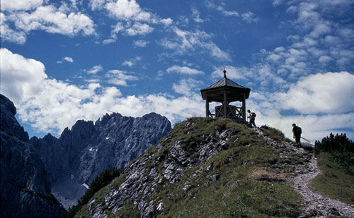
Summit shelter on the Stripsenkopf
| Start | Griesner Alm (986m) |
| Distance | 11km |
| Height gain | 827m |
| Height loss | 827m |
| Grade | 3 |
| Time | 5½–6hrs |
| Location | West of Gasteig |
This is a very fine outing – a ridge walk on the north side of the Kaiserbachtal with outstanding views of the Wilder Kaiser mountains almost every step of the way. You’ll need settled conditions as the ridge is no place to be caught in bad weather, and make sure you carry liquid refreshment and something to eat, for although the walk begins and ends at a gasthaus and visits a mountain hut (the Stripsenjochhaus), much of the route is well away from habitation.

Summit shelter on the Stripsenkopf
Begin at the Kaiserbachtal roadhead at the Alpengasthof Griesner Alm, cross the stream opposite and turn right at the footpath junction where a sign gives 1½hrs to the Stripsenjoch. This is described above as Route 70.
From the Stripsenjochhaus at 1577m, a signed path rises to the north, then forks about 15mins above the hut. Take the left branch for the Stripsenkopf (the right branch cuts across the east flank of the mountain on a more direct route to the Feldberg). In places the path calls for easy scrambling, aided by metal rungs and fixed cables, and above these you arrive at a minor saddle below the Hundskopf, whose summit is crowned by a metal cross. Turn left and continue to climb, reaching the ridge a little east of the Stripsenkopf. Again, turn left and walk up the final slope to the 1807m summit, on which there’s a small shelter (about 35mins from the Stripsenjochhaus).
Walk along the ridge heading northeast, but after a short distance the path leaves the crest and cuts down the steep right flank (caution when wet) to join the lower path which avoided the Stripsenkopf. Now the route rejoins the ridge crest and dodges from one side to the other; from the left side of the ridge you look directly down into the pastoral Weissenbach valley.
The lowest part of the ridge is reached at the Wiesensattel at 1627m, after which you climb again on the most scenic section of the route between the Stripsenkopf and Feldberg. There’s one short fixed cable, otherwise the path is straightforward, and it brings you onto a false summit (excellent views), after which you descend briefly, then up to a junction where a faint path breaks left to the Kohlalm. Ignore this path and keep ahead among dwarf pine which screens the views for a while. As you emerge from these, skirt a secondary high point and climb a final slope to gain the summit of Feldberg (1813m, 3½hrs).
Feldberg is a minor summit with the inevitable cross, and truly magnificent views across the Kaiserbachtal to the wonderful Wilder Kaiser peaks; north to the Walchsee and the flat country stretching into Germany, while Kufstein can be seen in the Inn Valley to the west.
Descend the ridge east of the summit, on a path weaving among more dwarf pine, and with another brief section of fixed cable. This takes you into several hollows before you descend to a grassy saddle and veer left ahead, then come to a more prominent saddle and a path junction (about 1465m, 45mins from the Feldberg summit).
Turn right and descend the steep south slope of the mountain, soon entering woodland. On emerging from the trees the way heads west on a descending traverse, and comes to another junction just above the building of Ranggenalm (1226m, refreshments sometimes available from the dairyman). One path drops past the hut on the way to Fischbachalm, but we contour westward, rising a little here and there and regaining another 100m or so before descending to the two alm buildings of Hintere Ranggenalm (also known as Ranggen Hochalm). Pass between the buildings to join the farm track which snakes its way down to Griesner Alm.