
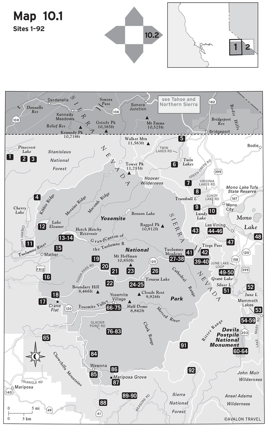
Plunging waterfalls, stark granite, alpine lakes, pristine meadows, giant sequoias, and raging rivers—you’ll find them all in this region, which encompasses not only Yosemite National Park but also Mammoth Lakes and the Eastern Sierra.
The centerpiece is Yosemite National Park, a must-see on every hiker’s itinerary. Just beyond the park boundaries lie the Hoover, Ansel Adams, and John Muir wilderness areas. To the east of Yosemite, Mammoth Lakes and June Lake offer unusual diversity—volcanic craters, hot springs, lava flows, the saline waters of Mono Lake, and the geologic wonders of Devils Postpile National Monument.
The prime season here is April through October, but the higher elevations are often accessible only from June to September. To avoid the crowds in hot spots like Yosemite Valley, travel in the offseason or on weekdays.


1 PINECREST LAKE NATIONAL RECREATION TRAIL
10 LAKE CANYON AND MAY LUNDY MINE
34 GLEN AULIN AND TUOLUMNE FALLS
37 TUOLUMNE MEADOWS TO SONORA PASS (PCT)
38 TUOLUMNE MEADOWS TO YOSEMITE VALLEY (JMT)
41 MIDDLE AND UPPER GAYLOR LAKES
45 SLATE CREEK TRAIL TO GREEN TREBLE LAKE
56 EMERALD LAKE AND SKY MEADOWS
60 DEVILS POSTPILE AND RAINBOW FALLS
64 AGNEW MEADOWS TO TUOLUMNE MEADOWS (JMT/PCT)
70 MIST TRAIL AND JOHN MUIR LOOP TO NEVADA FALL
73 INSPIRATION AND STANFORD POINTS
76 MCGURK MEADOW AND DEWEY POINT
80 TAFT POINT AND THE FISSURES
88 LEWIS CREEK NATIONAL RECREATION TRAIL
93 CONVICT CANYON TO LAKE DOROTHY
94 MCGEE CREEK TO STEELHEAD LAKE
4.2 mi / 2.0 hr

on Pinecrest Lake near Strawberry in Stanislaus National Forest
Pinecrest Lake is a tremendously popular family vacation resort just off Highway 108, the kind of place that people go year after year for a week of boating, camping, and fishing. Many own or rent cabins and stay all summer. The trail that circles its shoreline is a lot like the lake itself—it’s pretty and extremely popular. The four-mile loop makes a pleasant early morning walk or run, provided you’re up and at it before the crowds get out of bed. In the afternoons, you can hike to the east side of the lake and follow a spur trail along the South Fork Stanislaus River to some excellent swimming holes known as Cleo’s Bath. This trail is by no means a wilderness experience, but it’s a pleasant walk. If you’re looking for solitude, try it on an autumn weekday.
User Groups: Hikers and dogs. No horses or mountain bikes. Part of this trail is wheelchair-accessible.
Permits: No permits are required. Parking and access are free.
Maps: An Emigrant Wilderness map is available from Tom Harrison Maps or Stanislaus National Forest. For a topographic map, go to the USGS website to download Pinecrest.
Directions: From Sonora, drive east on Highway 108 for 31 miles to the Pinecrest turnoff. Turn right on Pinecrest Lake Road and continue for another mile to the day-use parking area, on the south side of the lake. Park as close to the end of the road as possible.
Contact: Stanislaus National Forest, Summit Ranger District, Pinecrest, 209/965-3434, www.fs.usda.gov/stanislaus.
8.0 mi / 4.0 hr

in the Emigrant Wilderness near Pinecrest Lake
The Crabtree trailhead, at elevation 7,180 feet, is the trailhead of choice for most casual hikers and backpackers entering the Emigrant Wilderness. It’s easy to reach and allows access to many excellent destinations with a relatively short walk. From Crabtree, it’s a moderate 2.6-mile hike to Camp Lake, which is just inside the Emigrant Wilderness boundary. This lake is best as a day-hiking destination, but some backpackers opt to spend the night here (there is a one-night limit). A better choice is to continue another 1.5 miles to Bear Lake, accessible via a one-mile left spur trail. Both lakes offer stellar granite-country scenery, good (but icy) swimming, decent rainbow trout fishing, and the chance to see plenty of early summer wildflowers. You, too, can be wowed by the wandering daisies and blue lupine. You’ll face only one sustained hill climb along the route; most of the trail gently undulates. Watch for beaver evidence at Bear Lake.
User Groups: Hikers, dogs, and horses. No mountain bikes. No wheelchair facilities.
Permits: A free wilderness permit is required for overnight stays and is available from the Summit Ranger Station. There is a one-night stay limit at Camp Lake. Parking and access are free.
Maps: An Emigrant Wilderness map is available from Tom Harrison Maps or Stanislaus National Forest. For a topographic map, go to the USGS website to download Pinecrest.
Directions: From Sonora, drive east on Highway 108 for 31 miles to the Pinecrest turnoff. Turn right on Pinecrest Lake Road and continue 0.5 mile to the right fork for Dodge Ridge Ski Area. Bear right and drive 2.9 miles, then turn right at the sign for Aspen Meadow and Gianelli trailhead. Drive 0.5 mile, turn left, and drive four miles to the turnoff for the Crabtree trailhead (follow the signs). Turn right and drive 0.25 mile.
Contact: Stanislaus National Forest, Summit Ranger District, Pinecrest, 209/965-3434, www.fs.usda.gov/stanislaus.
4.6 mi / 2.5 hr
in the Emigrant Wilderness near Pinecrest Lake
Both Burst Rock and Powell Lake are supreme day-hike destinations, but they present a problem for first-time visitors: Neither one is located right along the trail and neither one is signed. This results in a lot of people wandering around asking, "So which rock is Burst Rock?" The answer: it’s the entire plateau above the plaque commemorating the Clark-Skidmore Emigrant Party of 1852. You’ll see it after hiking gently but steadily uphill for 1.3 miles. At the wilderness boundary sign, cut off to your left for about 50 yards and you’ll witness an incredible vista looking out over the valley below. Retrace your steps and continue another mile until you reach a fork. Go left for less than 0.25 mile to Powell Lake, a favorite spot of young anglers. If you miss the fork, shortly you’ll catch sight of the lake, off to your left. The peninsula of rocks that juts out into the water is the perfect place for afternoon sunning and swimming. If you choose to camp at Powell Lake, note that there is a one-night stay limit.
User Groups: Hikers, dogs, and horses. No mountain bikes. No wheelchair facilities.
Permits: A free wilderness permit is required for overnight stays and is available from the Summit Ranger Station. There is a one-night stay limit at Powell Lake. Parking and access are free.
Maps: An Emigrant Wilderness map is available from Tom Harrison Maps or Stanislaus National Forest. For a topographic map, go to the USGS website to download Pinecrest.
Directions: From Sonora, drive east on Highway 108 for 31 miles to the Pinecrest turnoff. Turn right on Pinecrest Lake Road and continue for 0.5 mile to the right fork for Dodge Ridge Ski Area. Bear right, drive 2.9 miles, and turn right at the sign for Aspen Meadow and Gianelli trailhead. Drive 0.5 mile, turn left, and drive 8.3 miles to the trailhead parking area. The route is well signed.
Contact: Stanislaus National Forest, Summit Ranger District, Pinecrest, 209/965-3434, www.fs.usda.gov/stanislaus.
8.4 mi / 1-2 days

in northwest Yosemite National Park
This day hike or easy backpacking trip starts near Cherry Lake in Stanislaus National Forest and heads into the Hetch Hetchy region of Yosemite. Yes, much of this area was severely burned in the massive Rim Fire of 2013, but that just makes this trip all the more interesting—especially the long drive to Cherry Lake, which offers many views of the fire’s devastation. In the spring, you can see thousands of colorful lupines blooming amid the blackened soil. Kibbie Lake is a rewarding weekend trip for all levels of backpackers since the one-way distance is only 4.2 miles. From the trailhead, follow the Kibbie Ridge Trail 1.2 miles to the Kibbie Lake Trail, then go right and head for the lake in another three miles. Near this main junction you leave Stanislaus National Forest and enter Yosemite National Park, so dogs are not allowed past this point. The trail deposits you at the southern tip of the granite-bound lake, elevation 6,513 feet. Although quite large (more than 100 surface acres), Kibbie Lake is fairly shallow and supports a good population of rainbow trout. The long and narrow body of water has high rocky cliffs on some of its shoreline, so not all of it is easily accessible. On summer weekends, the lake gets visited fairly heavily, but on weekdays, you are likely to be the only soul around.
Note: Check your calendar before you go. The gate at Cherry Lake is closed every year one week before deer season, which is usually sometime in September, and doesn’t reopen until spring. Most years, the road is open from May 1 to September 15.
User Groups: Hikers and horses. No dogs or mountain bikes. No wheelchair facilities.
Permits: There is a $30 entrance fee per vehicle at Yosemite National Park ($25 Nov.-Mar.), good for seven days. Free wilderness permits are required for overnight stays. They are available on a first-come, first-served basis up to one day in advance at the Yosemite Wilderness kiosk near your chosen trailhead, or further in advance by mail, phone, or online for a $5 reservation fee per person.
Maps: A Hetch Hetchy map is available from Tom Harrison Maps. For topographic maps, go to the USGS website to download Kibbie Lake and Hetch Hetchy Reservoir.
Directions: From Groveland, drive east on Highway 120 for 14 miles toward Yosemite National Park. Turn left on Cherry Lake Road and drive 24 miles to Cherry Lake’s dam, then cross it. On the far side of the dam, bear right and drive 0.4 mile, then turn left on Road 1N45Y and follow it for 4.5 miles to its end at the Kibbie Ridge trailhead.
Contact: Yosemite National Park, Yosemite, 209/372-0200 or 209/372-0740 (permit reservations), www.nps.gov/yose or www.nps.gov/yose/wilderness (permit reservations).
5.0 mi / 2.5 hr

in Humboldt-Toiyabe National Forest west of Bridgeport and Highway 395
You can hike up to eight miles one-way along Buckeye Creek to the Hoover Wilderness boundary below the Buckeye Roughs. But most hikers do less than that; they just take off from Buckeye Campground (7,000 feet), maybe pack along their fishing rods, and walk a couple of miles each way up and down the stream. Brook trout are planted close to the campground all summer. It’s rare to hike far in the Eastern Sierra without having to climb, but that’s what you get here at the base of Buckeye Canyon. If you don’t like to fish, there’s plenty of other stuff to do, like admire the wildflowers in the meadows or gape at the impressive walls of glacial summits and ridges that surround you. A popular hot spring is found in Buckeye Creek less than a mile from the campground, but be forewarned: You might get an anatomy lesson there. Occasional Buckeye Creek bathers have been spotted wearing only birthday suits. Note that the lower portions of the Buckeye Creek Trail can be difficult to follow. Cattle graze this area in the summer and create their own trail system.
User Groups: Hikers, dogs, and horses. No mountain bikes. No wheelchair facilities.
Permits: No day-hiking permits are required. Parking and access are free.
Maps: A Hoover Wilderness map is available from Tom Harrison Maps or the U.S. Forest Service. For a topographic map, go to the USGS website to download Twin Lakes.
Directions: From Bridgeport on U.S. 395, drive west on Twin Lakes Road for seven miles to the Buckeye Road turnoff. Turn right on Buckeye Road and drive 3.5 miles to the Buckeye Campground and trailhead. (Buckeye Road turns to dirt at Doc and Al’s Resort.)
Contact: Humboldt-Toiyabe National Forest, Bridgeport Ranger District, HC Bridgeport, 760/932-7070, www.fs.usada.gov/htnf.
7.8 mi / 5.0 hr

in the Hoover Wilderness west of Bridgeport
Some call it Barney Lake Trail and others call it Robinson Creek Trail. Whatever you call it, you should know that this is the busiest trail into the Hoover Wilderness. Why? It’s downright easy, gaining only 1,000 feet along its four-mile length. The remedy for the crowds? Start hiking very early in the day, before the hundreds of campers in the Twin Lakes area have risen from their sleeping bags. You must park outside Mono Village Campground and then walk due east through it to reach the trailhead, which is signed for Barney Lake. (The attendant in the camp entrance kiosk can point you to the trailhead. Day hikers can park for free but backpackers must pay a parking fee.) The trail roughly parallels Robinson Creek, first in a pine forest and then skirting big meadows highlighted by vast stands of aspen trees. While in the wide open meadows, you are rewarded with impressive views of the jagged Sawtooth Range. The path passes a Hoover Wilderness sign at 1.5 miles, then climbs a bit more steeply and reaches the lake at 3.9 miles. If you get there before everyone else, you are one lucky hiker. Ambitious day hikers and backpackers can continue another 3.5 miles to larger Peeler Lake. Because of the amount of aspens seen along this trail, it’s a real treat to hike here from late September to mid-October when the color show happens.
User Groups: Hikers, dogs, and horses. No mountain bikes. No wheelchair facilities.
Permits: A free wilderness permit is required for overnight stays and is available from the Bridgeport Ranger Station. Quotas are in effect from the end of June to mid-September; permits are available in advance by mail for this period for a $3 fee per person.
Maps: A Hoover Wilderness map is available from Tom Harrison Maps or the U.S. Forest Service. For a topographic map, go to the USGS website to download Twin Lakes.
Directions: From Bridgeport on U.S. 395, drive west on Twin Lakes Road for 13.2 miles to the signed parking area, on the west end of the lakes, near Mono Village Campground.
Contact: Humboldt-Toiyabe National Forest, Bridgeport Ranger District, Bridgeport, 760/932-7070, www.fs.usada.gov/htnf.
8.6-11.6 mi / 5.0 hr

in the Hoover Wilderness west of Bridgeport
Three beautiful lakes—Green, East, and West—are situated right around 9,000 feet in elevation in the spectacular Hoover Wilderness. They offer fair trout fishing and are accessible via Green Creek Trail (sometimes called Green Lake Trail). It’s only 4.6 miles round-trip to Green Lake, but you can go two miles farther for an 8.6-mile round-trip that includes East Lake as well. Or, you can take a 1.5-mile spur off the main trail for a much steeper (but well worth it) jaunt to stark, rockbound West Lake. Some people make a short backpacking trip out of it and see all three lakes. If you do, note that Green Lake is the only one of the three that is just below 9,000 feet in elevation, which means it is the only one where campfires are permitted. (You must use the established campfire rings.) At the other, higher lakes, only backpacking stoves are allowed. The fishing is generally better at East and West Lakes than at Green Lake, although it’s nothing to write home about. The high mountain scenery, on the other hand, will knock your socks off.
The Green Creek Trail climbs, of course—but not so much that you’ll be worn out when you reach Green Lake; just enough to provide you with expansive valley views most of the way. The path closely parallels the tumbling cascades of the main fork of Green Creek, and the July wildflower show is outstanding here. (The autumn aspen show is also noteworthy.) The turnoff for West Lake is on the right at 2.2 miles. This trail makes a memorably steep 1,000-foot ascent over 1.5 miles, climbing high above Green Lake. After the easy grade of the first two miles of trail, this last stretch can really take you by surprise. For solitude lovers, West Lake is your best bet. The main trail reaches the shore of Green Lake 200 yards past the West Lake turnoff. East Lake can be reached by following the main trail (go left at the fork) and gaining another 500 feet in elevation over two miles. All three lakes are sparkling, rock-bound gems, so you can’t go wrong here no matter which one you choose to visit.
User Groups: Hikers, dogs, and horses. No mountain bikes. No wheelchair facilities.
Permits: A free wilderness permit is required for overnight stays and is available from the Bridgeport Ranger Station. Quotas are in effect from the end of June to mid-September; permits are available in advance by mail for this period for a $3 fee per person.
Maps: A Hoover Wilderness map is available from Tom Harrison Maps or the U.S. Forest Service. For a topographic map, go to the USGS website to download Twin Lakes.
Directions: From Bridgeport, drive south on U.S. 395 for 4.5 miles to Green Creek Road (dirt). Turn west and drive 8.2 miles to the signed trailhead parking area, shortly before Green Creek Campground.
Contact: Humboldt-Toiyabe National Forest, Bridgeport Ranger District, Bridgeport, 760/932-7070, www.fs.usada.gov/htnf.
6.2-10.2 mi / 3.0 hr-2 days
in the Hoover Wilderness south of Bridgeport
Virginia Lakes form the gateway to a beautiful high-mountain basin that contains eight small alpine lakes within a two-mile radius. The trailhead is at the Big Virginia Lake day-use area, set at 9,500 feet between mountain peaks that jut 12,000 feet into the sky. From here, you hike west past Blue Lake to Cooney Lake and on to Frog Lakes (a very easy 1.4 miles), then start climbing seriously, continuing 1.8 more miles to 11,100-foot Summit Pass. The landscape here is windswept, barren, and beautiful—a mix of rock, occasional whitebark pines, and high alpine wildflowers. Many hikers take a look at the scene from the pass, then retreat to one of the aforementioned lakes to spend the afternoon, making a 6.2-mile day. If you continue beyond the pass, you curve downhill through dozens of switchbacks for 1.4 miles, then climb gently 0.5 mile west to Summit Lake (at 10,203 feet), on the northeast boundary of Yosemite National Park. Summit Lake is set between Camiaca Peak (11,739 feet) to the north and Excelsior Mountain (12,446 feet) to the south. This is the logical place for backpackers to make camp, and for day-trippers to turn around for a 10.2-mile day. If you want to take a longer trip into even wilder country, you can do so from this point. The trail skirts Summit Lake’s north side, then enters Yosemite National Park in Virginia Canyon, one of the least-visited areas of the park. Another option is to take the fork right before Summit Lake that leads east (right) to the double Hoover Lakes, connecting with the Green Creek Trail. Some backpackers and day hikers make a one-way hike of about 11 miles out of this trip by arranging to have a shuttle car waiting for them at the Green Creek trailhead (see listing in this chapter).
User Groups: Hikers, dogs, and horses. No dogs on trail in the Yosemite National Park portion. No mountain bikes. No wheelchair facilities.
Permits: A free wilderness permit is required for overnight stays and is available from the Bridgeport Ranger Station. Quotas are in effect from the end of June to mid-September; permits are available in advance by mail for this period for a $3 fee per person.
Maps: A Hoover Wilderness map is available from Tom Harrison Maps or the U.S. Forest Service. For a topographic map, go to the USGS website to download Dunderberg Peak.
Directions: From Bridgeport, drive 13.5 miles south on U.S. 395 (or from Lee Vining, drive 12 miles north on U.S. 395) to Conway Summit. Turn west on Virginia Lakes Road and drive 6.5 miles to the trailhead, at the Big Virginia Lake day-use area.
Contact: Humboldt-Toiyabe National Forest, Bridgeport Ranger District, Bridgeport, 760/932-7070, www.fs.usada.gov/htnf.
4.4-10.0 mi / 2.0 hr-2 days
north of Lee Vining in the Hoover Wilderness
The Lundy Canyon Trail is the back door into the 20 Lakes Basin, a well-traveled area of the Hoover Wilderness that is most commonly accessed from Saddlebag Lake off Highway 120. The trailhead lies about two miles past Lundy Lake, a long, narrow pool set at 7,800 feet. From here, the trail rises along Mill Creek, passing several beaver ponds, a dilapidated trapper’s cabin, and two small but boisterous waterfalls (Lower and Upper Lundy Falls, also called Mill Creek Falls) as it heads into the Hoover Wilderness. Most visitors hike to the first or second falls, enjoying the gorgeous Eastern Sierra scenery with a relatively mellow walk, then hike back out. Those who continue find that the trail, which climbed gently but steadily for the first 2.2 miles, suddenly reaches what appears to be the back of the canyon. But look straight up the canyon wall to your left—that’s where the path continues, although it isn’t much of a path. An unmaintained, marginally switchbacked route leads 0.8 mile upward through a frighteningly steep wall of shale, and the difficulty rating for this trail changes abruptly from a 3 to a 4 (and maybe a 5 on the way back downhill). Use great caution here; one slip and you could take a nasty fall. You don’t want to be carrying a pack that is too heavy or unbalanced on this stretch.
When you finally make it to the top of the canyon wall, you come out to a beautiful high mountain meadow and a junction near the austere shores of Lake Helen, elevation 10,100 feet (3.3 miles from your start). By going right, you can follow the trail to Shamrock and Steelhead Lakes. Shamrock is 0.3 mile farther and dotted with many islands; Steelhead is another 0.5 mile beyond and is framed by 12,242-foot North Peak, towering above. The opposite trail goes left to Odell Lake (3.6 miles from your start). From Odell Lake, you could continue on to Hummingbird Lake, then to the north shore of Saddlebag Lake. If you can arrange a car shuttle at Saddlebag Lake, you can extend your trip into a one-way hike of seven miles, and that would save you the harrowing trip back down that shale-covered slope.
Note that one of the best times to visit here is in October, when Lundy Canyon’s stands of quaking aspen turn bright gold and seem to dance in the breeze. This is one of the best places to admire fall colors in the Eastern Sierra. July is another first-rate time to visit; the canyon’s wildflower displays are remarkable.
User Groups: Hikers, horses, and dogs. No mountain bikes. No wheelchair facilities.
Permits: A free wilderness permit is required for overnight stays and is available from the Mono Basin Scenic Area Visitors Center. There are no quotas on this trail, so advance reservations are not required.
Maps: A Hoover Wilderness map is available from Tom Harrison Maps or the U.S. Forest Service. For topographic maps, go to the USGS website to download Lundy and Dunderberg Peak.
Directions: From Lee Vining, drive north on U.S. 395 for seven miles to Lundy Lake Road. Turn west on Lundy Lake Road and drive five miles to Lundy Lake. Continue beyond the lake and Lundy Lake Resort, driving two miles farther on a dirt road that ends at the trailhead.
Contact: Inyo National Forest, Mono Basin Scenic Area Visitors Center, Lee Vining, 760/647-3044, www.fs.usda.gov/inyo.
7.0 mi / 3.5 hr or 2 days
north of Lee Vining in the Hoover Wilderness
The Lundy Lake area is blessed with two first-rate day-hiking trails that lead into two separate and distinct canyons: Lundy Canyon (see listing in this chapter) and Lake Canyon. Both paths offer so many rewards that when you drive up to Lundy Lake, it’s hard to decide which one to take. History buffs and fishing-minded hikers would do well to take this trip from Lundy’s dam into Lake Canyon, where they can see the remains of the May Lundy Mine. The mine was worked continuously for two decades starting in 1878, producing a total of about $2 million in gold. As a result, the surrounding community of Lundy grew to support 500 people, despite severe winters and deadly avalanches. Besides mining, a primary activity here was the operation of three sawmills along Lundy Creek, used to supply timber to the nearby bustling gold rush town of Bodie.
The hike to the May Lundy Mine is a fairly steep 3.5 miles one-way, climbing above Lundy Lake on the old mine road that was built in 1881. You can see the trail plain as day from the trailhead on the east side of Lundy Lake. The road/trail passes Blue Lake and Crystal Lake, where mining relics can be found. (Crystal Lake is 0.3 mile off the trail via a left fork.) Continue on the main trail, and you’ll see the mine remains—old railcar tracks, tailings, and a closed-off mine shaft. Just beyond is Oneida Lake, whose waters were used to run the stamp mill for the mine. Even without the fascinating traces of history, this is an extraordinarily beautiful place. You’ll want to linger awhile at sparkling Oneida Lake. Both the scenery and the fishing are quite rewarding.
User Groups: Hikers, horses, and dogs. No mountain bikes. No wheelchair facilities.
Permits: A free wilderness permit is required for overnight stays and is available from the Mono Basin Scenic Area Visitors Center. There are no quotas on this trail, so advance reservations are not required.
Maps: A Mono Lake map is available from Tom Harrison Maps. An Inyo National Forest map is available from the U.S. Forest Service. For a topographic map, go to the USGS website to download Lundy.
Directions: From Lee Vining, drive north on U.S. 395 for seven miles to Lundy Lake Road. Turn west on Lundy Lake Road and drive five miles to Lundy Lake’s dam, on the east side of the lake. Turn left and drive 0.25 mile to a locked gate and trailhead.
Contact: Inyo National Forest, Mono Basin Scenic Area Visitors Center, Lee Vining, 760/647-3044, www.fs.usda.gov/inyo.
8.8 mi / 4.0 hr or 2 days
in Stanislaus National Forest
Although some day hikers choose to suffer through the nearly intolerable grade of the Poopenaut Valley Trail to reach the swimming holes and fishing spots on the Tuolumne River’s free-flowing stretch west of Hetch Hetchy Dam, a much more pleasant approach is on the Preston Flat Trail. The trailhead is off Cherry Lake Road in Stanislaus National Forest, near the epicenter of the 2013 Rim Fire, the third largest wildfire in California’s history. But this foothill ecosystem is well adapted to fire, and the Preston Flat Trail shows plenty of regrowth already. A walk here is a fascinating study in wildfire ecology and recovery. The path travels 4.4 miles up the north side of the Tuolumne River Canyon on a gently undulating grade. Shortly before the trail’s end is a rock chimney and a few other remains of an old cabin that was built here by a homesteader named Preston. A few hundred yards farther is a photogenic vista of Preston Falls, a cascade formed where the Tuolumne River drops 15 feet over a granite ledge into a wide, clear pool. The cataract is just a half-mile downstream of Yosemite’s boundary line. If you want to stay overnight, you can. Several good campsites are found along the trail, which sticks closely to the river for most of its length.
Compared to the Poopenaut Valley Trail, the Preston Flat Trail is by far the better choice for hikers who wish to reach the river. Hike it in early spring, when the raging Tuolumne River provides the most exciting viewing. Those who wish to fish or swim should wait to visit until late spring or early summer, when the river quiets down. Winter is also a great option; the elevation is low enough that the trail is always snow-free.
User Groups: Hikers, horses, dogs, and mountain bikes. No wheelchair facilities.
Permits: A free campfire permit is required for overnight stays and is available from the Groveland Ranger Station. Parking and access are free.
Maps: A Stanislaus National Forest map is available from the U.S. Forest Service. For a topographic map, go to the USGS website to download Cherry Lake South.
Directions: From Groveland drive east on Highway 120 for 14 miles toward Yosemite. Turn left on Cherry Lake Road and drive 8.5 miles to Early Intake, where you cross a bridge over the Tuolumne River. Turn right on the far side of the bridge and drive 0.8 mile to the trailhead parking area at the end of the road, just beyond Kirkwood Powerhouse.
Contact: Stanislaus National Forest, Groveland Ranger District, Groveland, 209/962-7825, www.fs.usda.gov/stanislaus.
3.0 mi / 1.5 hr
in northwest Yosemite National Park
Lake Eleanor is a reservoir in the Hetch Hetchy region of Yosemite—not as famous or as large as Hetch Hetchy itself, but still having an important role in the San Francisco water storage system. The forest surrounding the lake was obliterated in the 2013 Rim Fire, and the Forest Service closed off access to Lake Eleanor and nearby Cherry Lake for nearly two years. It’s open now, and it’s incredible to see how much foliage is regenerating in this scorched landscape. Eleanor is no longer the beautiful Sierra gem that it once was, but it’s still worth a visit and a short walk, if only to witness the fascinating process of fire regrowth.
Originally a naturally shallow glacial lake, Lake Eleanor was "improved" by the city of San Francisco by damming Eleanor Creek in 1928, five years before O’Shaughnessy Dam at Hetch Hetchy was completed. The dam raised the lake’s water level 40 feet. Today it is the second largest lake in Yosemite after Hetch Hetchy. Its waters are not used by San Francisco as a drinking supply but rather to generate power. Set at an elevation of 4,657 feet, Lake Eleanor is popular with anglers who tote along a fishing rod while traversing the trail around the three-mile-long lake’s edge. The access road to Lake Eleanor ends at a gate 0.25 mile before the lake, so start your hike there, then take a mellow walk along the lake’s south and west shores. Much of Lake Eleanor’s western side is dotted with islands.
It takes more than an hour’s drive from Highway 120 to access Lake Eleanor, so people who come here to hike or fish often plan on spending the night. A first-come, first-served campground is located at nearby Cherry Lake, and several backpacking campsites are located on the northwest edge of Lake Eleanor (a wilderness permit is required). Note that the road to Lake Eleanor is open only May 1 to September 15 each year (the road is usually closed beyond Cherry Lake’s dam).
User Groups: Hikers and horses. No dogs or mountain bikes. No wheelchair facilities.
Permits: No permits are required for day hiking. Parking and access are free (the trailhead is outside Yosemite National Park).
Maps: A Hetch Hetchy map is available from Tom Harrison Maps. For a topographic map, go to the USGS website to download Lake Eleanor.
Directions: From Groveland, drive east on Highway 120 for 14 miles toward Yosemite National Park. Turn left on Cherry Lake Road and drive 24 miles to Cherry Lake’s dam, then across it. On the far side of the dam, bear right and drive 0.4 mile, then turn right on the dirt road that is signed for Lake Eleanor. Follow this road four miles to its end, at the gated Yosemite National Park boundary, 0.25 mile south of the lake.
Contact: Yosemite National Park, Yosemite, 209/372-0200, www.nps.gov/yose.
4.8 mi / 2.5 hr
in northwest Yosemite National Park
The trail to this spectacular early-season waterfall starts by crossing the giant O’Shaughnessy Dam, where you may pause to curse (or admire, depending on your sensibilities) the San Francisco politicians who in 1908 believed that flooding Hetch Hetchy Valley was a good idea. In terms of geology and natural features, Hetch Hetchy is a near twin to Yosemite Valley, although somewhat smaller in scale. The valley today is filled by an immense reservoir that supplies water and power to the city of San Francisco and environs. After walking across its impressive dam and passing through a dimly lit, 500-foot-long tunnel, the trail opens out to a mixed forest along the edge of the deep blue lake. Here you will start to see a fair amount of burned trees and other evidence of the 2013 Rim Fire. But that also means that the spring wildflower displays at Hetch Hetchy are better than ever. In 1.5 miles you reach Tueeulala Fall, a delicate wisp of a freefall that only runs during peak snowmelt, and is often dry by late May. Less than a mile farther you reach powerful Wapama Fall on Falls Creek, a Bridalveil-like plume of white water that makes a dramatic plunge into the reservoir. Depending on how early in the year you visit, you may get soaking wet standing on the sturdy steel bridges that cross over Wapama Fall’s coursing flow. In early spring, Wapama Falls sometimes flows so furiously that the park rangers have to close this trail. In late spring and early summer, the temperature can get hot out at Hetch Hetchy, so this spray of water can be very refreshing. If this is your first trip to this part of Yosemite, be sure to stop and read the interpretive plaques at the dam that explain about the building of Hetch Hetchy Reservoir and its service to the city of San Francisco. Whatever else you may think about it, it’s a fascinating story.
User Groups: Hikers only. No dogs, horses, or mountain bikes. No wheelchair facilities.
Permits: No permits are required. There is a $30 entrance fee per vehicle at Yosemite National Park ($25 Nov.-Mar.), good for seven days.
Maps: A Hetch Hetchy map is available from Tom Harrison Maps. For topographic maps, go to the USGS website to download Lake Eleanor and Hetch Hetchy Reservoir.
Directions: From Groveland, drive east on Highway 120 for 22.5 miles to the Evergreen Road turnoff signed for Hetch Hetchy Reservoir on the left, a mile west of the Big Oak Flat entrance to Yosemite. Drive north on Evergreen Road for 7.4 miles and turn right on Hetch Hetchy Road. Drive nine miles to the dam and trailhead.
Contact: Yosemite National Park, Yosemite, 209/372-0200 or 209/372-0740 (permit reservations), www.nps.gov/yose or www.nps.gov/yose/wilderness (permit reservations).
13.0 mi / 1 or 2 days
in northwest Yosemite National Park
It’s spring and you are hungering for a Yosemite backpacking trip, but Tuolumne Meadows is knee-deep in melting snow. This is a good time to hike the northern edge of Hetch Hetchy Reservoir (elevation 3,796 feet), admiring three stunning waterfalls along the way: Tueeulala, Wapama, and Rancheria. This easy backpacking trip (or long day hike, if you prefer) travels along the length of the reservoir to its far eastern edge, where the bears are some of the boldest in all of Yosemite. (Bear canisters are required for backpackers.) Whereas Tueeulala and Wapama Falls are both freefalling cataracts, Rancheria Falls is a series of rolling cascades pouring over polished granite.
To make the trip, follow the trail notes for Wapama Falls (see listing in this chapter), then continue onward, following the trail as it contours along the reservoir’s edge. Yes, there is some burn evidence here from the 2013 Rim Fire, and it’s fascinating to notice how some trees were scorched while their neighbors were not. For much of the walk you are high above the water, which allows fine views of Kolana Rock and its neighboring granite formations across the reservoir. The trail follows a gentle grade with many small ups and downs, gaining only 1,300 feet along its entire length. This trip is manageable even for beginning backpackers. Shoreline trout fishing in the reservoir can be good in spring and fall. And remember: Swimming in Hetch Hetchy is not allowed.
User Groups: Hikers and horses. No dogs or mountain bikes. No wheelchair facilities.
Permits: There is a $30 entrance fee per vehicle at Yosemite National Park, ($25 Nov.-Mar.), good for seven days. Free wilderness permits are required for overnight stays. They are available on a first-come, first-served basis up to one day in advance at the Yosemite Wilderness kiosk near your chosen trailhead, or further in advance by mail, phone, or online for a $5 reservation fee per person.
Maps: A Hetch Hetchy map is available from Tom Harrison Maps. For topographic maps, go to the USGS website to download Lake Eleanor and Hetch Hetchy Reservoir.
Directions: From Groveland, drive east on Highway 120 for 22.5 miles to the Evergreen Road turnoff signed for Hetch Hetchy Reservoir on the left, a mile west of the Big Oak Flat entrance to Yosemite. Drive north on Evergreen Road for 7.4 miles and turn right on Hetch Hetchy Road. Drive nine miles to the dam and trailhead.
Contact: Yosemite National Park, Yosemite, 209/372-0200 or 209/372-0740 (permit reservations), www.nps.gov/yose or www.nps.gov/yose/wilderness (permit reservations).
15.0 mi / 1 or 2 days
in northwest Yosemite National Park
Smith Peak and its environs were severely burned in the 2013 Rim Fire, but the Park Service reopened the trail to the peak quickly. This is a different hike than it used to be (there are a lot less trees!), but the view from the top (7,751 feet) is still worth the effort. The route begins by the Mather Ranger Station. Follow the Lookout Point Trail for 1.2 miles, then turn right on the trail signed for Smith Meadow. You’ll travel through a fire-scarred forest, then climb up a ridge to meet up with Cottonwood Creek at Lower Cottonwood Meadow, shortly followed by Upper Cottonwood Meadow. Smith Meadow lies another two miles farther, and just beyond it you’ll find a junction of trails. The path on the right is another popular route to Smith Peak leading from White Wolf Campground off Tioga Road. Campsites are found a short distance to the west at this junction. Get a good night’s rest before bagging Smith Peak the next morning. (You’ve hiked six miles thus far; it’s only 1.5 more to the summit.) The peak, like the nearby meadows, was named after a 1920s sheep rancher. Many people day hike this trail, but it’s possible to camp very near the summit, and if you do, you’ll be treated to a memorable sunset and sunrise, plus a panoramic view of the Grand Canyon of the Tuolumne River, situated 4,000 dramatic feet below you. To the east, Yosemite’s high country peaks are prominent, among them distinctive Mount Conness, Matterhorn Peak, and Mount Hoffman. Total elevation gain on this trip is 2,900 feet.
User Groups: Hikers only. No dogs, horses, or mountain bikes. No wheelchair facilities.
Permits: There is a $30 entrance fee per vehicle at Yosemite National Park, ($25 Nov.-Mar.), good for seven days. Free wilderness permits are required for overnight stays. They are available on a first-come, first-served basis up to one day in advance at the Yosemite Wilderness kiosk near your chosen trailhead, or further in advance by mail, phone, or online for a $5 reservation fee per person.
Maps: A Hetch Hetchy map is available from Tom Harrison Maps. For topographic maps, go to the USGS website to download Hetch Hetchy Reservoir.
Directions: From Groveland, drive east on Highway 120 for 22.5 miles to the Evergreen Road turnoff (on the left), signed for Hetch Hetchy Reservoir (it’s a mile west of the Big Oak Flat entrance to Yosemite). Drive north on Evergreen Road for 7.4 miles, then turn right on Hetch Hetchy Road. Drive 1.6 miles to the entrance kiosk by the Mather Ranger Station; the trail begins 100 yards past the entrance kiosk, just beyond the ranger station, on the right.
Contact: Yosemite National Park, Yosemite, 209/372-0200 or 209/372-0740 (permit reservations), www.nps.gov/yose or www.nps.gov/yose/wilderness (permit reservations).
3.8 mi / 2.5 hr
on the border of Stanislaus National Forest and northwest Yosemite National Park
Carlon Falls is a pretty cascade on the South Fork Tuolumne River in the far western region of Yosemite. It is so far west that the trailhead is actually in Stanislaus National Forest, outside the park border, in a region that is well known as the heart of the 2013 Rim Fire. It was the third largest wildfire in California history, and you’ll see much evidence of it as you drive through this region. But the trail to Carlon Falls was spared, and this short, easy hike remains one of the most popular on the west side of the park. The trailhead is across the river from Carlon Day-Use Area, a popular picnicking and fishing spot on the Tuolumne River. Follow the trail for a mere 50 feet and you enter Yosemite National Park, but with no park entrance fee and no waiting in line at the entrance kiosk. The path skirts along the river’s northern bank to reach the falls in just under two miles. It’s almost completely shaded, mostly level (except for one brief steep climb that skirts a landslide area), and fairly easy to follow, although it does require clambering over a few fallen trees. The waterfall drops in two tiers over wide granite ledges, and the riverbanks surrounding it are covered with big conifers and dense foliage. A bonus is that unlike most Yosemite waterfalls, Carlon Falls runs year-round. The waterfall’s namesakes are Dan and Donna Carlon, who operated the popular Carl Inn from 1916 to 1930 near what is now the Carlon Day-Use Area. This trail is popular with swimmers and anglers in summer, but mostly deserted the rest of the year.
User Groups: Hikers only. No dogs, horses, or mountain bikes. No wheelchair facilities.
Permits: No permits are required. Parking and access are free.
Maps: For a topographic map, go to the USGS website to download Ackerson Mountain.
Directions: From Groveland, drive east on Highway 120 for 22.5 miles to the Evergreen Road turnoff, signed for Hetch Hetchy Reservoir, one mile west of the Big Oak Flat entrance to Yosemite. Follow Evergreen Road north for one mile to the far side of the bridge just past Carlon Day-Use Area. Park on the right at the closed-off dirt road on the north side of the bridge, signed only as No Camping. There is room for about five cars. Begin hiking on the closed road, heading upstream. The road narrows to single track after about 100 yards.
Contact: Yosemite National Park, Yosemite, 209/372-0200, www.nps.gov/yose.
3.0 mi / 1.5 hr
in western Yosemite National Park
There are three giant sequoia groves in Yosemite National Park—Merced, Tuolumne, and Mariposa. Because the Merced Grove is the smallest of the three groves and requires the longest walk to reach it, it is the least visited. Generally it only gets traffic from people who enter Yosemite at the Big Oak Flat entrance and drive by it on their way to Yosemite Valley. The hiking is on a closed-off dirt road that is ideal for snowshoeing in winter. The trail cuts a level course through a mixed conifer forest for the first 0.5 mile. Bear left at the only junction and head downhill through a canopy of white firs, incense cedars, ponderosa pines, and sugar pines. You reach the small sequoia grove at 1.5 miles; the first group of six trees will take your breath away. Continue another 100 yards past these beauties; the two largest sequoias of the Merced Grove are directly across from a handsome old log cabin. It was originally built as a retreat for the park superintendent but is no longer used. Retrace your steps from the cabin, hiking uphill for your return.
User Groups: Hikers only. No dogs, horses, or mountain bikes. No wheelchair facilities.
Permits: No permits are required. There is a $30 entrance fee per vehicle at Yosemite National Park ($25 Nov.-Mar.), good for seven days.
Maps: A Yosemite National Park map is available from Tom Harrison Maps. For a topographic map, go to the USGS website to download Ackerson Mountain.
Directions: From Merced, drive 70 miles northeast on Highway 140 to Yosemite National Park. Follow the signs toward Yosemite Valley, entering through the Arch Rock entrance station. Continue 4.5 miles to the left turnoff for Highway 120, looping back out of the valley on Big Oak Flat Road. Continue straight on Big Oak Flat Road for 13.5 miles (past the Tioga Pass Road turnoff) to the Merced Grove parking area, on the left. If you enter Yosemite at the Big Oak Flat entrance station on Highway 120, drive 4.3 miles southeast to reach the trailhead, on your right.
Contact: Yosemite National Park, Yosemite, 209/372-0200, www.nps.gov/yose.
2.5 mi / 1.5 hr
in western Yosemite National Park
Up until 1993 you could drive right in to the Tuolumne Grove of Giant Sequoias, but now the road is closed off and visitors have to hike in. The grove is found on the old Big Oak Flat Road, a paved, six-mile historic road/trail that is open to bikes and hikers (although bikes are a rarity here). This is a popular destination, so arrive early in the morning to have the best chance at solitude. Leave your car at the parking lot near Crane Flat and hike downhill into the big trees. It’s one mile to the first sequoias. The Tuolumne Grove’s claim to fame is that it has one of the two remaining walk-through trees in Yosemite; this one is called the Dead Giant. It’s a tall stump that was tunneled in 1878. Go ahead, walk through it—everybody does. At a small picnic area, a half-mile trail loops around the forest. Make sure you save some energy for the trip back uphill to the parking lot; the moderate grade ascends 550 feet. The old paved road continues downhill beyond the grove all the way to Hodgdon Meadow Campground. Some people hike the entire six-mile distance, then have someone pick them up at Hodgdon Meadow.
User Groups: Hikers and mountain bikes. No dogs or horses. No wheelchair facilities.
Permits: No permits are required. There is a $30 entrance fee per vehicle at Yosemite National Park ($25 Nov.-Mar.), good for seven days.
Maps: A Yosemite National Park map is available from Tom Harrison Maps. For a topographic map, go to the USGS website to download Ackerson Mountain.
Directions: From Merced, drive 70 miles northeast on Highway 140 to Yosemite National Park. Follow the signs toward Yosemite Valley, entering through the Arch Rock entrance station. Continue 4.5 miles to the left turnoff for Highway 120, looping back out of the valley on Big Oak Flat Road. In 9.3 miles at Crane Flat, turn right on Tioga Pass Road, then drive 0.5 mile to the Tuolumne Grove parking lot, on the left, near Crane Flat. If you enter Yosemite at the Big Oak Flat entrance station on Highway 120, drive 7.7 miles southeast to the Crane Flat/Highway 120 East turnoff. Turn left and drive 0.5 mile to the Tuolumne Grove trailhead.
Contact: Yosemite National Park, Yosemite, 209/372-0200, www.nps.gov/yose.
5.6 mi / 3.0 hr
off Tioga Pass Road in Yosemite National Park
Harden Lake itself isn’t a scene stealer—by late summer, it’s not much more than a large pond, framed by a few stands of aspen trees on its northeast shore. But many people come here for another reason, and that’s to see the wildflowers that bloom in a region known informally as Harden’s Gardens, about a quarter-mile beyond the lake. July is the most dependable month for the wildflower bloom. Plus there are other rewards, including fine views of the Grand Canyon of the Tuolumne River just a half-mile north of the lake. Also, because of the small size of Harden Lake, it is dependably warm for swimming by midsummer. The hike is simple enough. The trail follows White Wolf’s gravel service road (a stretch of the original Tioga Road) past the campground entrance and across the Tuolumne River. Follow the obvious signs that point you through a few junctions to a blossom-filled marshy area. A few more steps and you’re at the lake. If you haven’t yet gotten your fill of the flower show, proceed a short distance farther and feast your eyes on Harden’s Gardens.
User Groups: Hikers only. No dogs, horses, or mountain bikes. No wheelchair facilities.
Permits: No permits are required. There is a $30 entrance fee per vehicle at Yosemite National Park ($25 Nov.-Mar.), good for seven days.
Maps: A Yosemite National Park map is available from Tom Harrison Maps. For a topographic map, go to the USGS website to download Tamarack Flat.
Directions: From Merced, drive 70 miles northeast on Highway 140 to Yosemite National Park. Follow the signs to Yosemite Valley, entering through the Arch Rock entrance station. Continue 4.5 miles to the left turnoff for Highway 120, looping back out of the valley on Big Oak Flat Road. In 9.3 miles at Crane Flat, turn right on Tioga Pass Road and drive 14 miles to the left turnoff for White Wolf. Turn left and drive one mile to the lodge and trailhead.
Contact: Yosemite National Park, Yosemite, 209/372-0200, www.nps.gov/yose.
1.5-4.6 mi / 1.0-2.0 hr
off Tioga Pass Road in Yosemite National Park
The Lukens Lake Trail is the perfect introductory lake hike for families in Yosemite National Park. A six-year-old could make the trip easily. A bonus is that the trailhead is on the western end of Tioga Road, so it’s quickly reached from points in Yosemite Valley. The trail is 0.75 mile long and leads from Tioga Road up to a saddle, then drops down to a meadow on the lake’s eastern edge. The path winds through a dense red fir forest, filled with mammoth trees, then skirts alongside a corn lily-filled meadow to the southern edge of the shallow, spring-fed lake (the trail used to travel on the lake’s north side, but it was rerouted). If you time it right—usually late July—you may see a spectacular wildflower show featuring thousands of pink shooting stars. Swimming in Lukens Lake is highly recommended; by midsummer, this is one of the warmest lakes in the park. If you want to take a longer trail to Lukens Lake, you can start from the trailhead at White Wolf Lodge and make a 4.6-mile round-trip.
User Groups: Hikers only. No dogs, horses, or mountain bikes. No wheelchair facilities.
Permits: No permits are required. There is a $30 entrance fee per vehicle at Yosemite National Park ($25 Nov.-Mar.), good for seven days.
Maps: A Yosemite National Park map is available from Tom Harrison Maps. For a topographic map, go to the USGS website to download Tamarack Flat.
Directions: From Merced, drive 70 miles northeast on Highway 140 to Yosemite National Park. Follow the signs to Yosemite Valley, entering through the Arch Rock entrance station. Continue 4.5 miles to the left turnoff for Highway 120, looping back out of the valley on Big Oak Flat Road. In 9.3 miles at Crane Flat, turn right on Tioga Pass Road and drive 16.2 miles to the Lukens Lake trailhead parking area, on the south side of the road. The trail begins across the road.
Contact: Yosemite National Park, Yosemite, 209/372-0200, www.nps.gov/yose.
12.8 mi / 1 or 2 days

off Tioga Pass Road in Yosemite National Park
The Ten Lakes area is incredibly popular with backpackers, so get your wilderness permit early. Or get an early-morning start and make this trip as a day hike; just be prepared for some serious climbing and long miles. From the Ten Lakes trailhead at Tioga Pass Road (elevation 7,500 feet), the path climbs steadily for the first four miles. There’s only one brutally steep stretch, which comes between miles four and five, after a pretty stroll around Half Moon Meadow. A series of tight switchbacks pulls you through a nasty 800-foot elevation gain to the top of a ridge and the Ten Lakes/Grant Lakes junction. From there, you make a choice. Turn right to reach Grant Lakes and head mostly downhill for a mile; or, to reach Ten Lakes, continue straight, soon heading steeply downhill for 1.4 miles. The Grant Lakes offer a little more solitude (good for day hikers), while the two larger of the Ten Lakes have the best campsites, with many trees along their shorelines offering protection from the wind. All of the lakes are sparkling, rockbound beauties. Whether you go to Ten Lakes or Grant Lakes, don’t miss taking a side trip to the rocky overlook above the Ten Lakes Basin. It’s only 0.5 mile from the Ten Lakes/Grant Lakes junction (continue straight for Ten Lakes, then take the unsigned trail to the left of the main trail and head for the highest point). Four of the Ten Lakes are visible from this promontory, as well as a section of the Grand Canyon of the Tuolumne.
User Groups: Hikers only. No dogs, horses, or mountain bikes. No wheelchair facilities.
Permits: There is a $30 entrance fee per vehicle at Yosemite National Park, good for seven days. Free wilderness permits are required for overnight stays. They are available on a first-come, first-served basis up to one day in advance at the Yosemite Wilderness kiosk near your chosen trailhead or further in advance by mail, phone, or online for a $5 reservation fee per person.
Maps: A Yosemite National Park map is available from Tom Harrison Maps. For topographic maps, go to the USGS website to download Yosemite Falls and Ten Lakes.
Directions: From Merced, drive 70 miles northeast on Highway 140 to Yosemite National Park. Follow the signs toward Yosemite Valley, entering through the Arch Rock entrance station. Continue 4.5 miles to the left turnoff for Highway 120, looping back out of the valley on Big Oak Flat Road. In 9.3 miles at Crane Flat, turn right on Tioga Pass Road and drive 19.4 miles to the Yosemite Creek and Ten Lakes trailhead parking area, which is on the south side of the road. The trail begins on the north side of the road.
Contact: Yosemite National Park, Yosemite, 209/372-0200 or 209/372-0740 (permit reservations), www.nps.gov/yose or www.nps.gov/yose/wilderness (permit reservations).
9.0 mi / 5.0 hr
off Tioga Pass Road in Yosemite National Park
There are those who say that climbing Half Dome is a bit of a disappointment, and not just because of the crowds. When you reach the top and check out the commanding view, the panorama of granite is not quite as awesome as you might expect, and that’s because you can’t see Half Dome—you’re standing on it.
That’s a dilemma that’s easy to fix. If Half Dome is an absolute necessity in your view of Yosemite, climb North Dome instead, which offers a heart-stopping view of that big piece of granite. The route is not for the faint of heart, but when you are way up high looking down at Tenaya Canyon and across at Half Dome and Clouds Rest—well, you’ll know why you came. The preferred route to North Dome begins at the Porcupine Creek trailhead on Tioga Pass Road, and has only a 1,500-foot gain to the summit. A dirt access road quickly brings you to a proper trail, signed as Porcupine Creek. Continue straight at two possible junctions near the 2.5-mile mark, heading due south for North Dome. After the third mile, your views begin to open up, providing fine vistas of North Dome and Half Dome and increasing your anticipation. At the trail junction at 4.5 miles, take the left spur for the final hike to North Dome’s summit. Surprise—it’s a downhill grade to reach it. Hope you brought a full supply of film or memory cards with you; the view from the top is sublime. Half Dome, just across the canyon, appears close enough to touch. Clouds Rest is a dramatic sight to the northeast. To the southwest, you can see cars crawling along the Yosemite Valley floor. On your return trip, consider taking the unsigned spur trail two miles from North Dome, at an obvious saddle. The spur leads a steep 0.25 mile to Indian Rock, the only natural arch on land in Yosemite. It’s great fun to climb around on.
User Groups: Hikers only. No dogs, horses, or mountain bikes. No wheelchair facilities.
Permits: There is a $30 entrance fee per vehicle at Yosemite National Park ($25 Nov.-Mar.), good for seven days. Free wilderness permits are required for overnight stays. They are available on a first-come, first-served basis up to one day in advance at the Yosemite Wilderness kiosk near your chosen trailhead or further in advance by mail, phone, or online for a $5 reservation fee per person.
Maps: A Half Dome or Yosemite National Park map is available from Tom Harrison Maps. For a topographic map, go to the USGS website to download Yosemite Falls.
Directions: From Merced, drive 70 miles northeast on Highway 140 to Yosemite National Park. Follow the signs toward Yosemite Valley, entering through the Arch Rock entrance station. Continue 4.5 miles to the left turnoff for Highway 120, looping back out of the valley on Big Oak Flat Road. In 9.3 miles at Crane Flat, turn right on Tioga Pass Road and drive 24.5 miles to the Porcupine Creek trailhead parking area, on the right, a mile past Porcupine Flat Campground.
Contact: Yosemite National Park, Yosemite, 209/372-0200 or 209/372-0740 (permit reservations), www.nps.gov/yose or www.nps.gov/yose/wilderness (permit reservations).
2.4-6.0 mi / 2.0-4.0 hr

off Tioga Pass Road in Yosemite National Park
Here’s a hike that you can take the kids on—well, the first part, anyway. It’s an easy 1.2 miles to May Lake, tucked in below 10,850-foot Mount Hoffman. The trail to the lake has a total elevation gain of only 400 feet, and better yet, it’s downhill all the way home. Attaining the summit of Mount Hoffman, on the other hand, requires a challenging ascent, and is best left to more seasoned hikers. (Leave the kids at home if you are going to continue from the shores of May Lake to the top of Mount Hoffman.) The trail to both destinations begins at the Snow Flat trailhead (two miles off Tioga Pass Road), passes through a lodgepole pine forest, climbs up a granite-lined slope, then drops down to May Lake’s southern shore. A High Sierra Camp is located here. Wandering along the scenic, granite-ringed shoreline is a pleasant way to spend the afternoon.
To turn this easy walk into a moderate butt-kicker, follow the obvious use trail to the west, which leads around to the north side of May Lake. From the northwest shore, a fairly distinct use trail leads to Hoffman’s summit. This is not an official park trail, and it requires scrambling skills and sure footing, especially as you near the top. It also requires good lungs and legs: You have to gain another 1,500 feet in about two miles. So why do it? The view from Mount Hoffman’s ridgeline is first-class, with Half Dome, Clouds Rest, Tenaya Lake, and May Lake all in sight. Mount Hoffman is the exact geographical center of Yosemite National Park. The peak has two main summits; the one with the weather station on top is the highest. Explore the entire ridgeline, and visit both summits if you have the time; the view is surprisingly different.
User Groups: Hikers and horses. No dogs or mountain bikes. No wheelchair facilities.
Permits: No permits are required. There is a $30 entrance fee per vehicle at Yosemite National Park ($25 Nov.-Mar.), good for seven days.
Maps: A Tuolumne Meadows or Yosemite National Park map is available from Tom Harrison Maps. For a topographic map, go to the USGS website to download Tenaya Lake.
Directions: From Merced, drive 70 miles northeast on Highway 140 to Yosemite National Park. Follow the signs toward Yosemite Valley, entering through the Arch Rock entrance station. Continue 4.5 miles to the left turnoff for Highway 120, looping back out of the valley on Big Oak Flat Road. In 9.3 miles at Crane Flat, turn right on Tioga Pass Road and drive 26.6 miles to the May Lake Road turnoff, on the left (near road marker T-21). Drive two miles to the trailhead parking lot.
Contact: Yosemite National Park, Yosemite, 209/372-0200, www.nps.gov/yose.
14.0 mi / 8.0 hr
off Tioga Pass Road in Yosemite National Park
Hiking to Clouds Rest is a trip that’s as epic as climbing Half Dome, but with far fewer people elbowing you along the way. With a 2,300-foot climb and 14 miles to cover, it’s not for those who are out of shape. The trail ascends steadily for the first four miles, descends steeply for 0.5 mile, then climbs again more moderately. Keep the faith—the first 2.5 miles from the trailhead are the toughest. The final summit ascent is a little dicey because of the terrifying dropoffs, but as with other Yosemite peaks, watch your footing on the granite slabs, and you’ll be fine. Overall, the route is much safer than climbing Half Dome, because the final ascent is far more gradual, and there are no cables to maneuver. The view from the top of Clouds Rest—of Tenaya Canyon, Half Dome, Yosemite Valley, Tenaya Lake, the Clark Range, and various peaks and ridges—will knock your socks off (hope you brought along an extra pair). Note that if this long hike has made you hot and sweaty, you can stop at the Sunrise Lakes for a swim on the way back—the first lake is only 0.25 mile from the Clouds Rest/Sunrise Trail junction.
User Groups: Hikers only. No dogs, horses, or mountain bikes. No wheelchair facilities.
Permits: No permits are required. There is a $30 entrance fee per vehicle at Yosemite National Park ($25 Nov.-Mar.), good for seven days.
Maps: A Tuolumne Meadows or Yosemite National Park map is available from Tom Harrison Maps. For a topographic map, go to the USGS website to download Tenaya Lake.
Directions: From Merced, drive 70 miles northeast on Highway 140 to Yosemite National Park. Follow the signs toward Yosemite Valley, entering through the Arch Rock entrance station. Continue 4.5 miles to the left turnoff for Highway 120, looping back out of the valley on Big Oak Flat Road. In 9.3 miles at Crane Flat, turn right on Tioga Pass Road and drive 30.3 miles to the Sunrise Lakes trailhead, on the south side of the highway just west of Tenaya Lake.
Contact: Yosemite National Park, Yosemite, 209/372-0200, www.nps.gov/yose.
7.5 mi / 4.5 hr or 2 days
off Tioga Pass Road in Yosemite National Park
With all the people hiking to Clouds Rest, combined with all the people hiking to the Sunrise Lakes, the Sunrise trailhead can look like a mall parking lot on a Saturday. But don’t be scared off; the hike to Sunrise Lakes is a great day hike or easy backpacking trip, especially during the week or off-season, with only a 1,000-foot elevation gain and a ton of stellar scenery, including great views of Clouds Rest at your back as you hike the final stretch to the lakes. You follow the trail as it climbs steeply above the edge of Tenaya Canyon. At 2.5 miles, turn left at the sign for the Sunrise High Sierra Camp. In about 10 minutes of easy walking, Lower Sunrise Lake shows up on the right, and the other lakes are shortly after it, on the left. The upper lake is the largest and by far the most popular; lots of folks like to swim and picnic there on warm summer days. Backpackers can pick a site here or continue onward for two more miles to the backpackers’ camp or the High Sierra Camp, depending on where they’ve made their plans.
User Groups: Hikers only. No dogs, horses, or mountain bikes. No wheelchair facilities.
Permits: There is a $30 entrance fee per vehicle at Yosemite National Park ($25 Nov.-Mar.), good for seven days. Free wilderness permits are required for overnight stays. They are available on a first-come, first-served basis up to one day in advance at the Yosemite Wilderness kiosk near your chosen trailhead or further in advance by mail, phone, or online for a $5 reservation fee per person.
Maps: A Tuolumne Meadows or Yosemite National Park map is available from Tom Harrison Maps. For a topographic map, go to the USGS website to download Tenaya Lake.
Directions: From Merced, drive 70 miles northeast on Highway 140 to Yosemite National Park. Follow the signs toward Yosemite Valley, entering through the Arch Rock entrance station. Continue 4.5 miles to the left turnoff for Highway 120, looping back out of the valley on Big Oak Flat Road. In 9.3 miles at Crane Flat, turn right on Tioga Pass Road and drive 30.3 miles to the Sunrise Lakes trailhead, on the south side of the highway just west of Tenaya Lake.
Contact: Yosemite National Park, Yosemite, 209/372-0200 or 209/372-0740 (permit reservations), www.nps.gov/yose or www.nps.gov/yose/wilderness (permit reservations).
2.0 mi / 1.0 hr
off Tioga Pass Road in Yosemite National Park
Lots of people drive east down Tioga Pass Road in a big rush to get to Tuolumne Meadows, but when they see giant Tenaya Lake right along the road, they stop short in their tire tracks. Luckily the 150-acre, sapphire-blue lake has a parking lot and picnic area at its east end, where you can leave your car and take a stroll down to the lake’s edge. Although most people stop at the white-sand beach and picnic tables to watch the rock climbers on nearby Polly Dome, you can leave the crowds behind by strolling to the south side of the beach and joining the newly restored trail built by the Yosemite Conservancy in 2015. The path leads along the back side of Tenaya Lake, far from the road on the north side. When you get to the lake’s west end, where the trail continues but the water views end, just turn around and walk back. It’s a perfect, easy hike alongside one of the most beautiful lakes in Yosemite. The Yosemite Conservancy plans to continue trail work here in 2016, eventually completing a loop trail around the lake.
User Groups: Hikers only. No dogs, horses, or mountain bikes. No wheelchair facilities.
Permits: No permits are required. There is a $30 entrance fee per vehicle at Yosemite National Park ($25 Nov.-Mar.), good for seven days.
Maps: A Tuolumne Meadows or Yosemite National Park map is available from Tom Harrison Maps. For a topographic map, go to the USGS website to download Tenaya Lake.
Directions: From Merced, drive 70 miles northeast on Highway 140 to Yosemite National Park. Follow the signs toward Yosemite Valley, entering through the Arch Rock entrance station. Continue 4.5 miles to the left turnoff for Highway 120, looping back out of the valley on Big Oak Flat Road. In 9.3 miles at Crane Flat, turn right on Tioga Pass Road and drive 31.7 miles to the eastern Tenaya Lake Picnic Area (another Tenaya Lake picnic area lies 0.5 mile west). The trail leads from the parking lot.
Contact: Yosemite National Park, Yosemite, 209/372-0200, www.nps.gov/yose.
7.4 mi / 4.0 hr or 2 days
near Tuolumne Meadows in Yosemite National Park
The Cathedral Lakes are a tremendously popular easy backpacking destination in Yosemite, but it’s such a short hike to reach them that they also make a great day trip. Located on a 0.5-mile spur off John Muir Trail, the lakes are within a classic glacial cirque, tucked in below 10,840-foot Cathedral Peak. It’s as scenic a spot as you’ll find anywhere in Yosemite. Campsites are found close to the lakes, but you will need to secure your wilderness permit way in advance in order to spend the night. From the trail’s start at Tioga Pass Road, you hike 3.2 miles on the John Muir Trail, with a 1,000-foot elevation gain. Much of the trail is shaded by lodgepole pines, but when the path breaks out of the trees, views of surrounding peaks (especially distinctive Cathedral Peak, which looks remarkably different from every angle) keep you oohing and ahhing the whole way. At 3.2 miles, turn right on the Cathedral Lake spur to reach the lower, larger lake in 0.5 mile. You’ll follow the lake’s inlet stream through a gorgeous meadow to the water’s edge—then start snapping photographs like crazy. Many hikers stop here and go no farther, but it’s a pity not to see Upper Cathedral Lake as well. To reach the upper lake, retrace your steps to John Muir Trail and continue another 0.5 mile. Fishing is often better in the upper lake, and the scenery is even more sublime.

Cathedral Peak towers over Cathedral Lakes
User Groups: Hikers and horses. No dogs or mountain bikes. No wheelchair facilities.
Permits: There is a $30 entrance fee per vehicle at Yosemite National Park ($25 Nov.-Mar.), good for seven days. Free wilderness permits are required for overnight stays. They are available on a first-come, first-served basis up to one day in advance at the Yosemite Wilderness kiosk near your chosen trailhead or farther in advance by mail, phone, or online for a $5 reservation fee per person.
Maps: A Tuolumne Meadows or Yosemite National Park map is available from Tom Harrison Maps. For a topographic map, go to the USGS website to download Tenaya Lake.
Directions: From Merced, drive 70 miles northeast on Highway 140 to Yosemite National Park. Follow the signs toward Yosemite Valley, entering through the Arch Rock entrance station. Continue 4.5 miles to the left turnoff for Highway 120, looping back out of the valley on Big Oak Flat Road. In 9.3 miles at Crane Flat, turn right on Tioga Pass Road and drive 37.4 miles to the Cathedral Lakes trailhead, on the right, by Tuolumne Meadows. Park your car in the pullouts on either side of Tioga Pass Road near the trailhead; there is no formal parking lot.
Contact: Yosemite National Park, Yosemite, 209/372-0200 or 209/372-0740 (permit reservations), www.nps.gov/yose or www.nps.gov/yose/wilderness (permit reservations).
19.0 mi / 3 or 4 days
near Tuolumne Meadows in Yosemite National Park
Although this loop is popular with hikers staying at the Vogelsang High Sierra Camp, backpackers who plan early can get a wilderness permit for their own self-designed trip. The traditional route is to head out on the western side of the loop along Rafferty Creek, then take a short spur and spend the night at Vogelsang Lake, which is without question the most visually dramatic spot seen on this trip. It’s flanked by Fletcher Peak, a steep and rugged wall of glacier-carved granite. Few trees can grow in this sparse, high-alpine environment. The next day, you rejoin the loop and continue eastward to Evelyn Lake, another favorite camping spot. When it’s time to return, you hike down to Lyell Fork, a 2,000-foot descent that takes a few hours, then meet up with John Muir Trail and follow it north through lush green and gorgeous Lyell Canyon, back to the trailhead at Tuolumne Meadows. The trailhead is at 8,600 feet—plenty high to start—and for the most part, the trail undulates along, never gaining or losing more than 2,000 feet.
User Groups: Hikers and horses. No dogs or mountain bikes. No wheelchair facilities.
Permits: There is a $30 entrance fee per vehicle at Yosemite National Park ($25 Nov.-Mar.), good for seven days. Free wilderness permits are required for overnight stays. They are available on a first-come, first-served basis up to one day in advance at the Yosemite Wilderness kiosk near your chosen trailhead or farther in advance by mail, phone, or online for a $5 reservation fee per person.
Maps: A Tuolumne Meadows or Yosemite National Park map is available from Tom Harrison Maps. For a topographic map, go to the USGS website to download Vogelsang Peak.
Directions: From Merced, drive 70 miles northeast on Highway 140 to Yosemite National Park. Follow the signs toward Yosemite Valley, entering through the Arch Rock entrance station. Continue 4.5 miles to the left turnoff for Highway 120, looping back out of the valley on Big Oak Flat Road. In 9.3 miles at Crane Flat, turn right on Tioga Pass Road and drive 39.5 miles to the Tuolumne Lodge and Wilderness Permits turnoff, on the right. Turn right and drive 0.4 mile toward Tuolumne Lodge. Park in the lot on the left signed for Dog Lake and John Muir Trail. The trail begins across the road from the parking lot. Additional parking is available in the Wilderness Permit parking lot, at the turnoff from Tioga Pass Road.
Contact: Yosemite National Park, Yosemite, 209/372-0200 or 209/372-0740 (permit reservations), www.nps.gov/yose or www.nps.gov/yose/wilderness (permit reservations).
8.0 mi / 4.0 hr
near Tioga Pass in Yosemite National Park
This mellow, pretty hike starts on John Muir Trail near Tuolumne Lodge, then heads east along the south side of the Dana Fork of the Tuolumne River. After two miles, the trail crosses the river and Tioga Pass Road, and heads uphill through a dense lodgepole pine forest to Lower Gaylor Lake, elevation 10,049 feet. The shallow lake is a deep turquoise color and is surrounded by a grassy alpine meadow. From its edge, you gain wide vistas of the peaks in the Tuolumne Meadows area. This is classic high-country beauty at its finest. Note that if you wish to get to the Middle and Upper Gaylor Lakes from the lower lake, you have to go cross-country. An easier way is to drive to the Tioga Pass trailhead and follow the trail notes in this chapter for the Middle and Upper Gaylor Lakes hike. Elevation at this trailhead is 9,250 feet; the total gain is about 800 feet to Lower Gaylor Lake, a gentle climb the whole way.
User Groups: Hikers only. No dogs, horses, or mountain bikes. No wheelchair facilities.
Permits: No permits are required. There is a $30 entrance fee per vehicle at Yosemite National Park ($25 Nov.-Mar.), good for seven days.
Maps: A Tuolumne Meadows or Yosemite National Park map is available from Tom Harrison Maps. For topographic maps, go to the USGS website to download Vogelsang Peak and Tioga Pass.
Directions: From Merced, drive 70 miles northeast on Highway 140 to Yosemite National Park. Follow the signs toward Yosemite Valley, entering through the Arch Rock entrance station. Continue 4.5 miles to the left turnoff for Highway 120, looping back out of the valley on Big Oak Flat Road. In 9.3 miles at Crane Flat, turn right on Tioga Pass Road and drive 39.5 miles to the Tuolumne Lodge and Wilderness Permits turnoff, on the right. Turn right and drive 0.4 mile toward Tuolumne Lodge, then park in the lot on the left signed for Dog Lake and John Muir Trail. The trail begins across the road from the parking lot. Additional parking is available in the Wilderness Permit parking lot, at the turnoff from Tioga Pass Road.
Contact: Yosemite National Park, Yosemite, 209/372-0200, www.nps.gov/yose.
4.5 mi / 2.5 hr
near Tuolumne Meadows in Yosemite National Park
Starting at the trailhead elevation of 8,600 feet, you have a mere 850-foot elevation gain over 2.25 miles to get to lovely Elizabeth Lake, set in a basin at the foot of distinctive Unicorn Peak. It’s a day hike that is attainable for almost anybody, and you can bet that every camper at Tuolumne Meadows Campground makes the trip at some point during their vacation. For noncampers, the trailhead is a bit tricky to find—it’s tucked into the back of Tuolumne Meadows Campground, across from the group camp restrooms. Once you locate it, be prepared to climb steeply for the first mile, then breathe easier when the trail levels out. Fortunately the route is mostly shaded by a dense grove of lodgepole pines. Upon reaching its shore, you’ll see that Elizabeth Lake is a gorgeous body of alpine water. Some visitors swim or fish here; others try to climb Unicorn Peak (10,900 feet); most are happy to sit near the lake’s edge and admire the views of the sculpted peak and its neighbors in the Cathedral Range.
User Groups: Hikers only. No dogs, horses, or mountain bikes. No wheelchair facilities.
Permits: No permits are required. There is a $30 entrance fee per vehicle at Yosemite National Park ($25 Nov.-Mar.), good for seven days.
Maps: A Tuolumne Meadows or Yosemite National Park map is available from Tom Harrison Maps. For a topographic map, go to the USGS website to download Vogelsang Peak.
Directions: From Merced, drive 70 miles northeast on Highway 140 to Yosemite National Park. Follow the signs toward Yosemite Valley, entering through the Arch Rock entrance station. Continue 4.5 miles to the left turnoff for Highway 120, looping back out of the valley on Big Oak Flat Road. In 9.3 miles at Crane Flat, turn right on Tioga Pass Road and drive 39 miles to the Tuolumne Meadows Campground. Turn right and follow the signs through the main camp to the group camp. The trail begins across from the group camp restrooms, near group site No. B49.
Contact: Yosemite National Park, Yosemite, 209/372-0200, www.nps.gov/yose.
6.0 mi / 3.0 hr
near Tuolumne Meadows in Yosemite National Park
This hike is one of the easiest in the Yosemite high country, and since it starts out beautiful and stays that way, you can hike it as long or as short as you like. The total trail length is six miles one-way, paralleling the Lyell Fork of the Tuolumne River on the Pacific Crest Trail/John Muir Trail. But most people just head out for two or three miles, carrying their fishing rods, and then turn back. To reach the Lyell Fork, you must first cross the Dana Fork on a footbridge less than 0.5 mile from the parking lot. Then after 0.5 mile, you cross the Lyell Fork on a second footbridge, and head left along the river’s south side. A third bridge takes you across Rafferty Creek and into Lyell Canyon. If you like looking at gorgeous meadows and a meandering river, this is your hike. Small trout are plentiful. A bonus is that backpacking sites are located three to four miles out on the trail, so if you get a wilderness permit, you can linger for a few days in paradise.
User Groups: Hikers and horses. No dogs or mountain bikes. No wheelchair facilities.
Permits: No permits are required. There is a $30 entrance fee per vehicle at Yosemite National Park ($25 Nov.-Mar.), good for seven days.
Maps: A Tuolumne Meadows or Yosemite National Park map is available from Tom Harrison Maps. For a topographic map, go to the USGS website to download Vogelsang Peak.
Directions: From Merced, drive 70 miles northeast on Highway 140 to Yosemite National Park. Follow the signs toward Yosemite Valley, entering through the Arch Rock entrance station. Continue 4.5 miles to the left turnoff for Highway 120, looping back out of the valley on Big Oak Flat Road. In 9.3 miles at Crane Flat, turn right on Tioga Pass Road and drive 39.5 miles to the Tuolumne Lodge and Wilderness Permits turnoff, on the right. Turn right and drive 0.4 mile toward Tuolumne Lodge; park in the lot on the left signed for Dog Lake and John Muir Trail. The John Muir Trail begins across the road from the parking lot. Additional parking is available in the Wilderness Permit parking lot, at the turnoff from Tioga Pass Road.
Contact: Yosemite National Park, Yosemite, 209/372-0200, www.nps.gov/yose.
14.6 mi / 1 or 2 days
near Tuolumne Meadows in Yosemite National Park
Starting from the Lembert Dome parking lot at 8,600 feet in elevation, the Young Lakes Loop is a classic Yosemite trip that works equally well as a short backpacking trip or a long day hike. The destination is a series of lakes set in a deep and wide glacial cirque—the kind of awesome scenery that sticks in your mind months later, when you’re sitting at a desk somewhere staring at your computer screen. The trip starts with a walk down the wide dirt road that leads to Soda Spring. Pick up the trail near Parson’s Lodge that leads to Glen Aulin, and follow it through lodgepole pines for 1.8 miles until you see the right turnoff for Young Lakes. Follow Young Lakes Trail for 3.5 more miles, climbing steadily. At 5.5 miles out, you’ll see the return leg of your loop leading off to the right (signed for Dog Lake). You’ll continue straight for another 1.5 miles to Lower Young Lake and a stunning view of Ragged Peak, Mount Conness, and White Mountain. Two more lakes are accessible within a mile to the east. If you have the energy, don’t miss the third, upper lake, the most visually stunning of them all, perched in a high meadow at 10,218 feet in elevation. When you’re ready to head home, retrace your steps to the junction, and take the eastern (left) fork, returning via Dog Lake and Lembert Dome. Be forewarned: If you loop back this way, it won’t be an all-downhill cruise, but the scenery makes the additional climbing worthwhile. If you’re exhausted from your trip to the lakes, skip the loop and return the way you came—it’s downhill all the way.
User Groups: Hikers and horses. No dogs or mountain bikes. No wheelchair facilities.
Permits: There is a $30 entrance fee per vehicle at Yosemite National Park ($25 Nov.-Mar.), good for seven days. Free wilderness permits are required for overnight stays. They are available on a first-come, first-served basis up to one day in advance at the Yosemite Wilderness kiosk near your chosen trailhead or farther in advance by mail, phone, or online for a $5 reservation fee per person.
Maps: A Yosemite National Park map is available from Tom Harrison Maps. For topographic maps, go to the USGS website to download Tioga Pass and Falls Ridge.
Directions: From Merced, drive 70 miles northeast on Highway 140 to Yosemite National Park. Follow the signs toward Yosemite Valley, entering through the Arch Rock entrance station. Continue 4.5 miles to the left turnoff for Highway 120, looping back out of the valley on Big Oak Flat Road. In 9.3 miles at Crane Flat, turn right on Tioga Pass Road and drive 39 miles to the Lembert Dome/Soda Spring/Dog Lake/Glen Aulin trailhead parking, on the left. Begin hiking on the western edge of the parking lot, where there is a gated dirt road signed for Soda Spring.
Contact: Yosemite National Park, Yosemite, 209/372-0200 or 209/372-0740 (permit reservations), www.nps.gov/yose or www.nps.gov/yose/wilderness (permit reservations).
16.0 mi / 1 or 2 days
near Tuolumne Meadows in Yosemite National Park
This hike could be called the Epic Waterfall Trip. If you hike the entire route, you’ll see so many waterfalls and so much water along the way that you’ll have enough memories to get you through a 10-year drought. Arrange for a wilderness permit in advance, or reserve a stay at the Glen Aulin High Sierra Camp, so that you can divide the 16 miles over two or more days. If you’re in good enough shape, you can do the trip in one day, because the trail is nearly level for the first four miles (a 400-foot elevation loss), then descends more steeply over the next four miles (a 1,500-foot elevation loss). Unfortunately, all the climbing must be done on the way home, so you must reserve your energy and have plenty of food and water (or at least a purifying device so you can filter water from the river).
Follow the trail notes for Glen Aulin and Tuolumne Falls (see listing in this chapter) for the first four miles of trail; then continue downstream past Glen Aulin Camp, alternating between stretches of stunning flower- and aspen-lined meadows and stark granite slabs. Waterwheel Falls is only three miles from the camp, and two other major cascades, California and LeConte, are along the way. To see all three falls, make sure you take each spur trail you see that leads to the river; none of the waterfalls is apparent from the main trail. Other hikers will stop you on the trail to ask if you know where the waterfalls are. Whereas all three falls are long white-water cascades, Waterwheel is considered Yosemite’s most unusual-looking waterfall because it has sections of churning water that dip into deep holes in the granite, then shoot out with such velocity that they double back on themselves. When the river level is high, they actually appear to circle around like waterwheels.
User Groups: Hikers and horses. No dogs or mountain bikes. No wheelchair facilities.
Permits: There is a $30 entrance fee per vehicle at Yosemite National Park ($25 Nov.-Mar.), good for seven days. Free wilderness permits are required for overnight stays. They are available on a first-come, first-served basis up to one day in advance at the Yosemite Wilderness kiosk near your chosen trailhead or farther in advance by mail, phone, or online for a $5 reservation fee per person.
Maps: A Tuolumne Meadows or Yosemite National Park map is available from Tom Harrison Maps. For topographic maps, go to the USGS website to download Tioga Pass and Falls Ridge.
Directions: From Merced, drive 70 miles northeast on Highway 140 to Yosemite National Park. Follow the signs toward Yosemite Valley, entering through the Arch Rock entrance station. Continue 4.5 miles to the left turnoff for Highway 120, looping back out of the valley on Big Oak Flat Road. In 9.3 miles at Crane Flat, turn right on Tioga Pass Road and drive 39 miles to the Lembert Dome/Soda Spring/Dog Lake/Glen Aulin trailhead parking, on the left. Begin hiking on the western edge of the parking lot, where there is a gated dirt road signed for Soda Spring.
Contact: Yosemite National Park, Yosemite, 209/372-0200 or 209/372-0740 (permit reservations), www.nps.gov/yose or www.nps.gov/yose/wilderness (permit reservations).
9.0 mi / 5.0 hr
near Tuolumne Meadows in Yosemite National Park
Those who aren’t up for the Epic Waterfall Trip to Waterwheel Falls (see listing in this chapter) can take this trip instead and maybe even sneak in a good meal at the Glen Aulin High Sierra Camp. To stay in the camp, you must reserve a spot far in advance, but you can often purchase a hot meal just by showing up. Tuolumne Falls drop right by the High Sierra Camp, and reaching the waterfall requires only a 4.5-mile walk with a 400-foot elevation loss. The return climb is easy, with most of the ascent being in the first mile as you head up and over the various cascades of Tuolumne Falls on granite stairs. Follow the dirt road from the Lembert Dome parking lot toward Soda Spring. When you near Parson’s Lodge, veer right on the signed trail to Glen Aulin. You’ll walk through lodgepole pine forest, then move closer to the Tuolumne River and get incredible views of Cathedral and Unicorn Peaks, as well as Fairview Dome. After three miles, you’ll cross the Tuolumne on a footbridge, and in another 0.25 mile, you’ll reach the first stunning drop of Tuolumne Falls, a 100-foot, churning freefall. Keep descending past more cascades to the base of the falls, where another footbridge leads back across the river and to Glen Aulin. Pick a spot downstream beside a river pool or near the bridge at the base of the waterfall, have a seat, and ponder the exquisite beauty of this place.
User Groups: Hikers and horses. No dogs or mountain bikes. No wheelchair facilities.
Permits: No permits are required. There is a $30 entrance fee per vehicle at Yosemite National Park ($25 Nov.-Mar.), good for seven days.
Maps: A Tuolumne Meadows or Yosemite National Park map is available from Tom Harrison Maps. For topographic maps, go to the USGS website to download Tioga Pass and Falls Ridge.
Directions: From Merced, drive 70 miles northeast on Highway 140 to Yosemite National Park. Follow the signs toward Yosemite Valley, entering through the Arch Rock entrance station. Continue 4.5 miles to the left turnoff for Highway 120, looping back out of the valley on Big Oak Flat Road. In 9.3 miles at Crane Flat, turn right on Tioga Pass Road and drive 39 miles to the Lembert Dome/Soda Spring/Dog Lake/Glen Aulin trailhead parking, on the left. Begin hiking on the western edge of the parking lot, where there is a gated dirt road signed for Soda Spring.
Contact: Yosemite National Park, Yosemite, 209/372-0200, www.nps.gov/yose.
2.8 mi / 1.5 hr
near Tuolumne Meadows in Yosemite National Park
Lembert Dome is a roche moutonné (a French geologic term that means it looks something like a sheep). We never see the resemblance, but we did feel like a couple of mountain goats when we climbed Lembert Dome, elevation 9,450 feet. From the parking area at the base, you can see rock climbers practicing their stuff on the steep side of the dome, but luckily the hiker’s trail heads around to the more-sloped back side. You can walk right up the granite—no ropes necessary. The Dog Lake and Lembert Dome Trail winds its way steeply around to the dome’s north side (see listing in this chapter); from there, pick any route along the granite that looks manageable. When you reach the top of the dome, you know that you’ve accomplished something. The view from its highest point—of Tuolumne Meadows and surrounding peaks and domes—is more than worth the effort.
User Groups: Hikers only. No dogs, horses, or mountain bikes. No wheelchair facilities.
Permits: No permits are required. There is a $30 entrance fee per vehicle at Yosemite National Park ($25 Nov.-Mar.), good for seven days.
Maps: A Tuolumne Meadows or Yosemite National Park map is available from Tom Harrison Maps. For a topographic map, go to the USGS website to download Tioga Pass.
Directions: From Merced, drive 70 miles northeast on Highway 140 to Yosemite National Park. Follow the signs toward Yosemite Valley, entering through the Arch Rock entrance station. Continue 4.5 miles to the left turnoff for Highway 120, looping back out of the valley on Big Oak Flat Road. In 9.3 miles at Crane Flat, turn right on Tioga Pass Road and drive 39 miles to the Lembert Dome/Soda Spring/Dog Lake/Glen Aulin trailhead parking, on the left. Begin hiking on the trail near the restrooms.
Contact: Yosemite National Park, Yosemite, 209/372-0200, www.nps.gov/yose.
3.4 mi / 2.0 hr
near Tuolumne Meadows in Yosemite National Park
Dog Lake is an easy-to-reach destination from Tuolumne Meadows, a perfect place for a family to spend an afternoon in the high country. The hike begins near the base of Lembert Dome, then heads through a gorgeous meadow that offers views of snowy Cathedral and Unicorn Peaks. The trail traverses a granite slab, then splits off from the path to Lembert Dome and starts to climb quite steeply through a lodgepole pine and fir forest. When you reach an intersection with Young Lakes Trail, you’re only 0.25 mile from Dog Lake. The lake is a delight, although with its grassy shoreline, it is often plagued with mosquitoes (don’t forget the bug spray). Set at 9,170 feet in elevation, it is wide, shallow, and deep blue. The colorful peaks to the east are Mount Dana and Mount Gibbs. You can hike around Dog Lake’s perimeter if you please, take a swim in late summer, or just sit by the peaceful shoreline and relax.
User Groups: Hikers and horses. No dogs or mountain bikes. No wheelchair facilities.
Permits: No permits are required. There is a $30 entrance fee per vehicle at Yosemite National Park ($25 Nov.-Mar.), good for seven days.
Maps: A Tuolumne Meadows or Yosemite National Park map is available from Tom Harrison Maps. For a topographic map, go to the USGS website to download Tioga Pass.
Directions: From Merced, drive 70 miles northeast on Highway 140 to Yosemite National Park. Follow the signs toward Yosemite Valley, entering through the Arch Rock entrance station. Continue 4.5 miles to the left turnoff for Highway 120, looping back out of the valley on Big Oak Flat Road. In 9.3 miles at Crane Flat, turn right on Tioga Pass Road and drive 39 miles to the Lembert Dome/Soda Spring/Dog Lake/Glen Aulin trailhead parking, on the left. Begin hiking on the trail near the restrooms.
Contact: Yosemite National Park, Yosemite, 209/372-0200, www.nps.gov/yose.
77.0 mi one-way / 8 days

from Tuolumne Meadows on Highway 120 north to Sonora Pass on Highway 108
This is a spectacular week-plus backpack trip that follows a section of the Pacific Crest Trail (PCT). The beauty of this region’s deep canyons, glacial-cut peaks, verdant meadows, and abundant wildlife makes it a hiker’s paradise.
From Tuolumne Meadows, the trail starts out deceptively easy as it follows the Tuolumne River toward the Grand Canyon of the Tuolumne River. It heads gently downhill to Glen Aulin, where you get a great view of Tuolumne Falls. When you cross the bridge at the base of the falls and head up-canyon, you’ll leave the day hikers behind. In the next three days, you’ll go up one canyon and down the next, one after another, with breathtaking views and long, demanding climbs. Highlights include Matterhorn Canyon (many deer, trout, and views), Benson Lake (the largest white-sand beach in the Sierra Nevada), Dorothy Lake (panoramic views to the north), and many pristine, high-country meadows. The incredible clouds of mosquitoes at the Wilmer Lake area during early summer can be a major annoyance.
When you leave Yosemite and enter Humboldt-Toiyabe National Forest, the landscape changes quickly from glacial-cut granite to volcanic rock. The trail drops past several pretty lakes and into a river drainage, and at points can be difficult to follow. In a few areas, you may be surprised to meet up with grazing cows, especially from midsummer onward. You’ll make a long, slow, climb up toward Leavitt Pass, set just below 10,800-foot Leavitt Peak. This landscape is entirely above tree line, in gray, stark country. At Leavitt Pass, the wind whistles by at high speed almost year-round. The final drop down to Sonora Pass is a one-hour descent that seems to wind all over the mountain. When you reach Highway 108, cross the road and walk about 100 yards west to a large day-use parking area. That’s where your car shuttle should be waiting for you.
User Groups: Hikers and horses. No dogs or mountain bikes. No wheelchair facilities.
Permits: A wilderness permit is required for traveling through various wilderness and special-use areas the trail traverses. Contact either the Wilderness Office of the National Park Service or the Stanislaus National Forest for a permit that is good for the length of your trip. There is a $30 entrance fee per vehicle at Yosemite National Park ($25 Nov.-Mar.), good for seven days.
Maps: For topographic maps, go to the USGS website to download Pickel Meadow, Tower Peak, Piute Mountain, Matterhorn Peak, Dunderberg Peak, Vogelsang Peak, Tioga Pass, Falls Ridge, Buckeye Ridge, and Sonora Pass.
Directions: From Merced, drive 70 miles northeast on Highway 140 to Yosemite National Park. Follow the signs toward Yosemite Valley, entering through the Arch Rock entrance station. Continue 4.5 miles to the left turnoff for Highway 120, looping back out of the valley on Big Oak Flat Road. In 9.3 miles at Crane Flat, turn right on Tioga Pass Road and drive 39 miles to the Lembert Dome/Soda Spring/Dog Lake/Glen Aulin trailhead parking, on the left. Begin hiking on the western edge of the parking lot, where there is a gated dirt road signed for Soda Spring.
Contact: Yosemite National Park, Yosemite, 209/372-0200, www.nps.gov/yose; Stanislaus National Forest, Calaveras Ranger Station, Hathaway Pines, 209/795-1381, www.fs.usda.gov/stanislaus.
22.0 mi one-way / 2 days
near Tuolumne Meadows in Yosemite National Park
The first glimpses of Yosemite Valley will seem like a privileged view into heaven after having hiked the entire John Muir Trail (JMT) from Mount Whitney. For hikers making only this 22-mile section, the rewards can seem just as profound. The trip starts at Tuolumne Meadows, where backpackers can buy a good cheap breakfast, obtain wilderness permits, and camp in a special area set aside for JMT hikers. When you take your first steps away from Tuolumne Meadows, resist the urge to rush to the finish line in order to close out a historic expedition. Instead, relax and enjoy the downhill glide, always remembering that you are in sacred land. Compared to the rest of the JMT, this leg will come with far less strain, starting with a 3.1-mile tromp past Cathedral Lakes and requiring a 0.5-mile walk on a signed cutoff trail. If you can time it right, this area can make a great layover camp, with deep, emerald-green water and Cathedral Peak in the background. Beyond Cathedral Lakes, the trail makes a relatively short 500-foot climb over Cathedral Pass, skirts Tresidder Peak, and then descends through pristine Long Meadow. After passing Sunrise Trail Camp, a decent layover, the trail picks up little Sunrise Creek and follows it all the way down to Little Yosemite Valley, a popular trail camp. From Cathedral Lakes, it’s 14.5 miles to the junction of Half Dome Trail, and another 2.2 miles to Little Yosemite.
For JMT hikers, making the climb to the top of Half Dome is a must, even though it often means putting up with a parade of people and even delays waiting for the line to move at the climbing cable. The Half Dome climb starts with a steep hike for the first mile, followed by steep switchbacks across granite on good trail to the foot of Half Dome’s back wall. Here you’ll find climbing cables to aid your final 300-foot ascent, and as you go, you’ll discover breathtaking views of Tenaya Canyon. This is considered one of the world’s glamour hikes, and while it turns hiking into an act of faith, we have seen eight-year-olds and 70-year-olds make the cable climb. By the way, if you take on Half Dome, be certain to have two canteens of water per person. Adding the Half Dome side trip to the rest of the JMT leg will add a round-trip of 5.2 miles to your hike. Because of its proximity to Half Dome, the Little Yosemite Valley Trail Camp is often crowded. From here, though, it’s an easy five-mile hike downhill to Yosemite Valley. Again, try not to speed through to the end, even though it’s an easy tromp downhill all the way. The magic is in the moment.
From Little Yosemite, the JMT is routed along the Merced River. In a mile, you’ll reach Liberty Cap, and shortly later, Nevada Fall. Then down, down you go, with the trail often turning to giant granite steps, down past Emerald Pool and then to Vernal Fall, another spectacular waterfall. Since Vernal Fall is just 1.7 miles from the end of the trail, you’ll start meeting lots of day hikers coming from the other direction, many gasping for breath as they make the uphill climb out of Yosemite Valley. Many will ask how far you’ve hiked; some may even want to take your photograph. It may feel a bit inane, but, hey, enjoy it. After all, you just finished John Muir Trail, the greatest hiking trail in the world.
User Groups: Hikers and horses. No dogs or mountain bikes. No wheelchair facilities.
Permits: A wilderness permit is required for traveling through various wilderness and special-use areas that the trail traverses. Contact the Wilderness Office of the National Park Service for a permit that is good for the length of your trip. There is a $30 entrance fee per vehicle at Yosemite National Park ($25 Nov.-Mar.), good for seven days.
Maps: A John Muir Trail Map Pack is available from Tom Harrison Maps. For topographic maps, go to the USGS website to download Vogelsang Peak, Half Dome, Yosemite Falls, and Tenaya Peak.
Directions: From Merced, drive 70 miles northeast on Highway 140 to Yosemite National Park. Follow the signs toward Yosemite Valley, entering through the Arch Rock entrance station. Continue 4.5 miles to the left turnoff for Highway 120, looping back out of the valley on Big Oak Flat Road. In 9.3 miles at Crane Flat, turn right on Tioga Pass Road and drive 39.5 miles to the Tuolumne Lodge and Wilderness Permits turnoff, on the right. Turn right and drive 0.4 mile toward Tuolumne Lodge; park in the lot on the left signed for Dog Lake and John Muir Trail. The John Muir Trail begins across the road from the parking lot. Additional parking is available in the Wilderness Permit parking lot, at the turnoff from Tioga Road.
Contact: Yosemite National Park, Yosemite, 209/372-0200 or 209/372-0740 (permit reservations), www.nps.gov/yose or www.nps.gov/yose/wilderness (permit reservations).
8.4 mi / 4.5 hr
near Tioga Pass in Yosemite National Park
With an elevation gain of only 900 feet spread out over four miles, you’ll hardly even notice you’re climbing on the route to Mono Pass. That’s if you’re acclimated, of course, because you start out at 9,700 feet, where the air is mighty thin. The Mono Pass Trail begins in a mix of lodgepole pines and grassy meadows, then crosses the Dana Fork of the Tuolumne River, which is an easy boulder-hop by midsummer. (Earlier in the season you may need to find a log to cross.) The trail soon meets up with Parker Pass Creek and parallels it for most of the trip. As you proceed, you’ll gain great views of Mount Gibbs, Mount Dana, and the Kuna Crest. At a trail junction at 2.0 miles, bear left and start to climb more noticeably. When you reach the Mono Pass sign at 3.8 miles, take the right spur trail (unsigned). It leads 0.3 mile to a cluster of four 19th-century mining cabins, which have been beautifully restored. It’s fascinating to explore the small cabins and surrounding mine ruins and consider the hard life of those who lived and worked here. Then, heading back to the main trail, continue another 0.5 mile beyond the sign marking Mono Pass for the best views of the trip. From a granite promontory above a water-filled tarn, you can see far down Bloody Canyon to Mono Lake and the surrounding desert.
User Groups: Hikers and horses. No dogs or mountain bikes. No wheelchair facilities.
Permits: No permits are required. There is a $30 entrance fee per vehicle at Yosemite National Park ($25 Nov.-Mar.), good for seven days.
Maps: A Yosemite High Country map is available from Tom Harrison Maps. For a topographic map, go to the USGS website to download Tioga Pass.
Directions: From Merced, drive 70 miles northeast on Highway 140 to Yosemite National Park. Follow the signs toward Yosemite Valley, entering through the Arch Rock entrance station. Continue 4.5 miles to the left turnoff for Highway 120, looping back out of the valley on Big Oak Flat Road. In 9.3 miles at Crane Flat, turn right on Tioga Pass Road and drive 44.5 miles to the Mono Pass trailhead on the right, 1.5 miles west of Tioga Pass.
Contact: Yosemite National Park, Yosemite, 209/372-0200, www.nps.gov/yose.
9.0 mi / 5.0 hr
near Tioga Pass in Yosemite National Park
Another option on the Mono Pass Trail (see trail notes for previous hike) is to take the right fork at 2.0 miles and head for Spillway Lake, a wide, shallow lake that is only 1.6 miles from this junction, and then large Helen Lake, which is reached by some easy cross-country travel. It seems like a completely different trip than the aforementioned hike to Mono Pass. The highlights here are two high alpine lakes that epitomize the beauty of the Yosemite high country. Backpackers rarely travel to these lakes, so day hikers are likely to have more solitude here. The views of the Kuna Crest and the high alpine meadow surrounding the upper reaches of Parker Pass Creek will take your breath away. A maintained trail travels to Spillway Lake, and from its southeast edge you simply follow Helen Lake’s outlet creek uphill to the shores of Helen Lake. Helen Lake is set at 11,000 feet in elevation, and it’s as lovely as any high mountain lake can be. Total elevation gain to see both lakes is only 1,300 feet.
User Groups: Hikers only. No dogs, horses, or mountain bikes. No wheelchair facilities.
Permits: No permits are required. There is a $30 entrance fee per vehicle at Yosemite National Park ($25 Nov.-Mar.), good for seven days.
Maps: A Yosemite High Country map is available from Tom Harrison Maps. For a topographic map, go to the USGS website to download Tioga Pass.
Directions: From Merced, drive 70 miles northeast on Highway 140 to Yosemite National Park. Follow the signs toward Yosemite Valley, entering through the Arch Rock entrance station. Continue 4.5 miles to the left turnoff for Highway 120, looping back out of the valley on Big Oak Flat Road. In 9.3 miles at Crane Flat, turn right on Tioga Pass Road and drive 44.5 miles to the Mono Pass trailhead on the right, 1.5 miles west of Tioga Pass.
Contact: Yosemite National Park, Yosemite, 209/372-0200, www.nps.gov/yose.
4.0 mi / 2.5 hr
near Tioga Pass in Yosemite National Park
Middle and Upper Gaylor Lakes are deservedly popular destinations, because of the short distance required to reach them and their great opportunities for trout fishing. Oh yeah, and then there is the amazing high-alpine scenery. Starting near Tioga Pass (at nearly 10,000 feet), the trail climbs a steep ridge and then drops down to Middle Gaylor Lake. Although it’s only one mile of ascent, it’s a high-elevation butt-kicker that causes many to beg for mercy. From the middle lake, you can follow the creek gently uphill to the east for another mile to reach smaller Upper Gaylor Lake. Be sure to take the trail around its north side and uphill for a few hundred yards to the site of the Great Sierra Mine and the remains of an old stone cabin. The Great Sierra Mine turned out to be not so great—no silver ore was ever refined, and the mine was eventually abandoned. The hauntingly beautiful glacial scenery is what remains. Total elevation gain on the hike to Upper Gaylor Lake is about 1,000 feet, and it’s worth every step. If you want to see more of this sublime lake basin, the twin Granite Lakes lie about 0.75 mile northwest of Middle Gaylor Lake. Although there is no formal trail, it’s an easy cross-country ramble to see the Granite Lakes as well, which are tucked in below a massive granite cirque.
User Groups: Hikers only. No dogs, horses, or mountain bikes. No wheelchair facilities.
Permits: No permits are required. There is a $30 entrance fee per vehicle at Yosemite National Park ($25 Nov.-Mar.), good for seven days.
Maps: A Yosemite High Country map is available from Tom Harrison Maps. For a topographic map, go to the USGS website to download Tioga Pass.
Directions: From Merced, drive 70 miles northeast on Highway 140 to Yosemite National Park. Follow the signs toward Yosemite Valley, entering through the Arch Rock entrance station. Continue 4.5 miles to the left turnoff for Highway 120, looping back out of the valley on Big Oak Flat Road. In 9.3 miles at Crane Flat, turn right on Tioga Pass Road and drive 46 miles to the parking lot just west of the Tioga Pass entrance station, on the north side of Tioga Pass Road.
Contact: Yosemite National Park, Yosemite, 209/372-0200, www.nps.gov/yose.
6.0 mi / 4.0 hr

near Tioga Pass in Yosemite National Park
Mount Dana is a grueling hike. Yet many hikers make the trip every summer, perhaps as some sort of rite of passage to affirm that the long winter has truly ended in the high country. The path to the 13,053-foot summit requires a 3,100-foot elevation gain condensed into a mere three miles. To make matters more difficult, there is no maintained trail, only a series of informal "use" trails created by generations of hearty Yosemite hikers who have traveled the route. To join their ranks, leave your car at the Gaylor Lakes trailhead by the Tioga Pass entrance station, then cross the road and hike southeast on the unsigned but obvious trail that begins just a few feet from the park entrance kiosk. The path starts with a pleasant ramble through Dana Meadows, then enters a dense lodgepole pine forest. Soon the grade becomes more intense, but this first stretch of climbing is highlighted by a spectacular wildflower show that usually peaks in late July. Lupine, larkspur, Indian paintbrush, senecia—they’re all here, in all their glory. The climbing gets tougher on the second mile of the hike, but stick with it and soon you’ve climbed above 11,000 feet, and now you’re above tree line. The path keeps ascending to the 11,600-foot mark, where a giant trail cairn marks a large, rock-covered plateau. This is a good place to rest and do a check on your physical and mental state. Although the summit may look close from here, you still have a long, hard way to go. Two fairly obvious paths head uphill from this point; if you’re feeling comfortable with the altitude, pick either one and continue onward, zigzagging your way up the shale-covered slope. In the final mile you must gain 1,500 feet, and to say it is slow going would be a major understatement. There’s no shade, often a fierce wind, plenty of loose rock underfoot, and the breathtakingly thin air of high altitude. With what may seem like your last breath, you finally reach the summit, where you are witness to one of the finest views in the Sierra. Your field of vision encompasses Mono Lake, Ellery and Saddlebag Lakes, Glacier Canyon, Tuolumne Meadows, Lembert Dome, and an untold wealth of high peaks. Bring a map and identify all you can survey, or forget the map and just take in the majesty of it all.
A few tips for making the ascent safely: First, wait until mid-July or later to make the trip, as Mount Dana can be snow-covered long into the summer. Second, get an early start in the morning so you have no chance of encountering afternoon thunderstorms. Third, carry (and drink) as much water as you can. Fourth, wear good sunglasses and sun protection at this high elevation. And lastly, pace yourself to give your body a chance to adjust to the 13,000-foot altitude.
User Groups: Hikers only. No dogs, horses, or mountain bikes. No wheelchair facilities.
Permits: No permits are required. There is a $30 entrance fee per vehicle at Yosemite National Park ($25 Nov.-Mar.), good for seven days.
Maps: A Yosemite High Country map is available from Tom Harrison Maps. For a topographic map, go to the USGS website to download Tioga Pass.
Directions: From Merced, drive 70 miles northeast on Highway 140 to Yosemite National Park. Follow the signs toward Yosemite Valley, entering through the Arch Rock entrance station. Continue 4.5 miles to the left turnoff for Highway 120, looping back out of the valley on Big Oak Flat Road. In 9.3 miles at Crane Flat, turn right on Tioga Pass Road and drive 46 miles to the parking lot just west of the Tioga Pass entrance station, on the north side of Tioga Pass Road. The trail begins on the south side of Tioga Pass Road; begin hiking on the unsigned trail across from the park entrance kiosk.
Contact: Yosemite National Park, Yosemite, 209/372-0200, www.nps.gov/yose.
2.6 mi / 2.0 hr

in Inyo National Forest just east of Tioga Pass
This first-class high-country hike is suitable for even the most novice hikers, and is sure to spark your imagination. The remote high-country region of Bennettville was the site of a 19th-century silver mining community. Although the town thrived only from 1882 to 1884, it was the primary reason for the construction of the Tioga Pass Road from the west. The original road, called the Great Sierra Wagon Road, was built by the Great Sierra Consolidated Silver Company in anticipation of the riches they would make from the mines at Bennettville and nearby. Ultimately, no valuable minerals were ever extracted, and the company went broke in record time. A mostly level trail leads to the two buildings that remain from Bennettville’s heyday: the assay office and barn/bunkhouse. An open mine tunnel lined with railcar tracks can also be seen, as well as some rusting mining equipment. Much of the machinery and supplies for this mine was hauled here from the May Lundy Mine over Dore Pass. Men and animals carried several tons of equipment on their backs and on sleds, sometimes through driving snowstorms in the middle of winter at this 10,000-foot elevation.
You can extend this hike by following the trail alongside Mine Creek 0.5 mile uphill from the mine buildings to small Shell Lake, followed by three more shallow lakes in the next mile or so: Mine, Fantail, and finally Spuller. More mine sites can be seen along the way. The high-country landscape here is a mix of open meadows, delicate high-alpine wildflowers, and wind-sculpted whitebark pines. The scenery is as good as you’ll find anywhere, and you’ll want to return to this area again and again.
User Groups: Hikers, horses, and dogs. No mountain bikes past Shell Lake (wilderness boundary). No wheelchair facilities.
Permits: No permits are required. Parking and access are free.
Maps: A Yosemite High Country map is available from Tom Harrison Maps. An Inyo National Forest map is available from the U.S. Forest Service. For a topographic map, go to the USGS website to download Tioga Pass.
Directions: From Merced, drive 70 miles northeast on Highway 140 to Yosemite National Park. Follow the signs toward Yosemite Valley, entering through the Arch Rock entrance station. Continue 4.5 miles to the left turnoff for Highway 120, looping back out of the valley on Big Oak Flat Road. In 9.3 miles at Crane Flat, turn right on Tioga Pass Road and drive 48 miles (you’ll exit the park) to the Saddlebag Lake turnoff, on the left, two miles east of Tioga Pass. Turn left, and then left again immediately, to enter Junction Campground. The trail begins at the campground entrance.
Contact: Inyo National Forest, Mono Basin Scenic Area Visitors Center, Lee Vining, 760/647-3044, www.fs.usda.gov/inyo.
2.0 mi / 2.0 hr
in Hoover Wilderness just east of Tioga Pass
How can a two-mile round-trip hike be rated a 3 for difficulty? It can because it goes straight up, gaining 700 feet in just one mile, with not nearly enough switchbacks. Although the trail distance is short, the trailhead is set at 9,800 feet, which means you need to be well acclimated to pant your way through that steep of a grade. The trip offers many rewards, though, including many fewer people than at nearby Saddlebag Lake and a stellar high-alpine setting. Once you huff and puff your way to the ridge top, you have a nearly level 0.25-mile stroll through a fragile alpine meadow to reach the lake, a shallow body of water surrounded by high-alpine meadows. That 11,513-foot mountain you see as you climb (ahead and to your right) is Tioga Peak; from the southwest edge of Gardisky Lake it’s a short but steep tromp to its windy summit (this will add a couple extra miles and 1,000 feet of extra elevation gain to your day). White Mountain and Mount Conness are also prominent, both over 12,000 feet.
User Groups: Hikers, horses, and dogs. No mountain bikes. No wheelchair facilities.
Permits: No permits are required for day-use; an overnight permit is required for backpacking. Parking and access are free.
Maps: A Yosemite High Country map is available from Tom Harrison Maps. An Inyo National Forest map is available from the U.S. Forest Service. For a topographic map, go to the USGS website to download Tioga Pass.
Directions: From Merced, drive 70 miles northeast on Highway 140 to Yosemite National Park. Follow the signs toward Yosemite Valley, entering through the Arch Rock entrance station. Continue 4.5 miles to the left turnoff for Highway 120, looping back out of the valley on Big Oak Flat Road. In 9.3 miles at Crane Flat, turn right on Tioga Pass Road and drive 48 miles (you’ll exit the park) to the Saddlebag Lake turnoff, on the left, two miles east of Tioga Pass. Turn left and go 1.3 miles to the trailhead parking area, on the west side of the road before you reach Saddlebag Lake. The trail begins across the road.
Contact: Inyo National Forest, Mono Basin Scenic Area Visitors Center, Lee Vining, 760/647-3044, www.fs.usda.gov/inyo.
4.5 mi / 2.0 hr
in Hoover Wilderness just east of Tioga Pass
One of the most beautiful and serene campgrounds in the High Sierra, Sawmill Walk-In Camp is accessed by a quarter-mile walk from its parking area. A wide trail continues through and past the campsites into Hall Research Natural Area, a specially protected region of Inyo National Forest that is open to day hikers only (no backpacking). The trail leads one mile to Timberline Station, an old research station built in 1929. From here you can cross Slate Creek and hike another mile to Green Treble Lake at the headwaters of Slate Creek. Where two forks of the creek join, about 0.5 mile beyond Timberline Station, follow the south fork (left) another 0.5 mile to Green Treble Lake. This is a remarkably level hike at 10,000-plus feet in elevation—pristine high country that is only accessible a few months each year. You know you are in a special place when you are here.
User Groups: Hikers, horses, and dogs. No mountain bikes. No wheelchair facilities.
Permits: No permits are required. Parking and access are free.
Maps: A Yosemite High Country map is available from Tom Harrison Maps. An Inyo National Forest map is available from the U.S. Forest Service. For a topographic map, go to the USGS website to download Tioga Pass.
Directions: From Merced, drive 70 miles northeast on Highway 140 to Yosemite National Park. Follow the signs toward Yosemite Valley, entering through the Arch Rock entrance station. Continue 4.5 miles to the left turnoff for Highway 120, looping back out of the valley on Big Oak Flat Road. In 9.3 miles at Crane Flat, turn right on Tioga Pass Road and drive 48 miles (you’ll exit the park) to the Saddlebag Lake turnoff, on the left, two miles east of Tioga Pass. Turn left and drive 1.5 miles north on Saddlebag Lake Road to Sawmill Campground’s parking area on the left.
Contact: Inyo National Forest, Mono Basin Scenic Area Visitors Center, Lee Vining, 760/647-3044, www.fs.usda.gov/inyo.
3.6-8.4 mi / 2.0-4.0 hr
in Inyo National Forest just east of Tioga Pass
Starting from the resort buildings at the south end of 10,087-foot Saddlebag Lake, you can design a wonderfully scenic hiking trip into the 20 Lakes Basin of any length that suits your time and energy. A benefit of hiking here is that you can cut off some miles by taking the boat taxi across the lake, rather than hiking along its lakeshore. A one-way ride on the boat taxi will cut 1.5 miles off your mileage; a round-trip cuts off three miles. Unfortunately, this high-country region is so beautiful, so easy to access, and so close to Yosemite that on summer weekends, it can be as crowded as the most popular trails in the park. A great time to hike here is a few weeks after Labor Day, when the vacation crowds have dispersed.
To hike alongside Saddlebag Lake instead of riding in the boat taxi, follow the trail on either the lake’s east or west side. The east side trail is more scenic; the west side trail is shorter. If you just want to make a short 3.6-mile loop, hike out on one trail and back on the other, but be sure to take the short left spur at Saddlebag’s northwest edge to Greenstone Lake, which is backed by photogenic North Peak. If you want to hike farther, you can continue past Greenstone Lake to Wasco Lake and then on to deep, stark Steelhead Lake (three miles out if you start on the west side trail). Several more lakes lie beyond, including Shamrock, Helen, and Odell. If you hike the entire loop and visit all six lakes that lie immediately beyond Saddlebag, you’ll have an 8.4-mile day (or a 5.4-mile day, if you take the boat taxi round-trip). No matter how far you go, you’ll be awed by the incredible high-country scenery—a blend of blue sky, granite, water, and hardy whitebark pines.
User Groups: Hikers and dogs. No horses or mountain bikes. No wheelchair facilities.
Permits: No permits are required. Parking and access are free.
Maps: A Yosemite High Country map is available from Tom Harrison Maps. An Inyo National Forest map is available from the U.S. Forest Service. For a topographic map, go to the USGS website to download Tioga Pass.
Directions: From Merced, drive 70 miles northeast on Highway 140 to Yosemite National Park. Follow the signs toward Yosemite Valley, entering through the Arch Rock entrance station. Continue 4.5 miles to the left turnoff for Highway 120, looping back out of the valley on Big Oak Flat Road. In 9.3 miles at Crane Flat, turn right on Tioga Pass Road and drive 48 miles (you’ll exit the park) to the Saddlebag Lake turnoff, on the left, two miles east of Tioga Pass. Turn left and drive another 2.7 miles to the trailhead parking area.
Contact: Inyo National Forest, Mono Basin Scenic Area Visitors Center, Lee Vining, 760/647-3044, www.fs.usda.gov/inyo.
5.4 mi / 2.5 hr or 2 days
west of Lee Vining on the northern boundary of the Ansel Adams Wilderness
The 2.7-mile hike from Upper Horse Meadow to Gibbs Lake is a great day hike that sees surprisingly few people. Since the trailhead isn’t located at a lake or some other attractive setting, nobody gets here by accident. The trail starts at Upper Horse Meadow (elevation 8,000 feet), and climbs up Gibbs Canyon to Gibbs Lake, at 9,530 feet. That’s about a 1,500-foot climb, but unfortunately the first stretch goes straight uphill on an old dirt road with nary a switchback. Once you get through that grunt of an ascent, the rest of the route is on a much mellower grade as it travels alongside Gibbs Creek. The trail ends at Gibbs Lake, a lovely glacial cirque that is backed by bare granite and fronted by conifers. Are you feeling ambitious? If you study the lake’s back wall for a few minutes, it will soon become obvious that there is another, higher lake in this drainage. If you are sure-footed and have plenty of energy, you can pick out your route and go take a look at that lake. Although Gibbs Lake is pretty, the higher Kidney Lake (10,388 feet) is a stunner. It will take you about 40 minutes of challenging cross-country scrambling to get from Gibbs to Kidney; you’ll gain almost 900 feet in less than a mile. Just pick your route carefully and go slow. Kidney Lake is indeed kidney-shaped, and it is flanked by the Dana Plateau on one side and Mount Gibbs (12,773 feet) on the other.
Note: While not required, high-clearance vehicles are a good idea on Forest Road 1N16.
User Groups: Hikers, horses, and dogs. No mountain bikes beyond the wilderness boundary. No wheelchair facilities.
Permits: A free wilderness permit is required for overnight stays and is available from the Mono Basin Scenic Area Visitors Center. Quotas are in effect from May 1 to November 1; for this period, permits are available in advance for a $5 reservation fee per person.
Maps: Mono Lake and Mammoth High Country maps are available from Tom Harrison Maps. An Inyo National Forest or Ansel Adams Wilderness map is available from the U.S. Forest Service. For a topographic map, go to the USGS website to download Lee Vining.
Directions: From Lee Vining, drive 1.3 miles south on U.S. 395 and turn west on unsigned Forest Road 1N16 (look for the sign indicating Horse Meadow). Drive 3.4 miles past Upper Horse Meadow to the trailhead at the end of the road. A high-clearance vehicle is recommended.
Contact: Inyo National Forest, Mono Basin Scenic Area Visitors Center, Lee Vining, 760/647-3044, www.fs.usda.gov/inyo.
1.0 mi / 0.5 hr
at the southern end of Mono Lake in Mono Lake Tufa State Reserve
The strange and remarkable tufa towers at Mono Lake create one of the most extraordinary landscapes in California. The terrain resembles a moonscape, but a strangely beautiful one. The area is extremely popular with photographers, especially at sunset. This short loop trail is the best way to get a good look at the tufa formations, which are formed when calcium-rich underwater springs are released from the lake bottom and then combine with Mono Lake’s saline water, forming calcium carbonate. The trail leads through sagebrush plains to the southern shore of the lake, where the tufas rest like old, untouched earth castles. Some of them poke out of the lake surface; others are high and dry on land. Mono Lake itself is vast (covering 60 square miles) and is estimated to be more than 700,000 years old, making it one of the oldest lakes in North America. The lake’s basin has become one of the world’s most prolific stopover points for gulls, grebes, plovers, and phalaropes during their annual southbound flights. That’s because the alkaline properties of the water create prime habitat for brine shrimp (an ideal food for these birds), and the lake’s two large islands provide isolation from predators. Eighty-five percent of the California gull population was born at Mono Lake.

Mono Lake South Tufa Trail
User Groups: Hikers, horses, dogs, and wheelchairs. No mountain bikes.
Permits: No permits are required. A $3 entrance fee is charged per adult. Youth ages 17 and under are free.
Maps: A Mono Lake map is available from Tom Harrison Maps. For topographic maps, go to the USGS website to download Lee Vining and Mono Mills.
Directions: From Lee Vining, drive five miles south on U.S. 395 and turn east on Highway 120 (signed for Mono Lake South Tufa). Drive 4.7 miles, then turn left and drive one mile on a dirt road to the parking area.
Contact: Mono Lake Tufa State Reserve, 760/647-6331, www.parks.ca.gov; Inyo National Forest, Mono Basin Scenic Area Visitors Center, Lee Vining, 760/647-3044, www.fs.usda.gov/inyo.
8.2 mi / 5.0 hr
southwest of Lee Vining at the northeastern boundary of the Ansel Adams Wilderness
Lower Sardine Lake is a jewel cradled in a high glacial cirque at 9,888 feet, the kind of lake that makes the Ansel Adams Wilderness one of the most treasured places in the world. Beyond the first easy mile, this hike is tough and steep. Much of the trail is a historic Native American trading route, used by the Indians of the Mono Basin to visit the Indians of the Yosemite high country. The first mile to Walker Lake is an easy downhill cruise, dropping 600 feet in elevation. Walker Lake is a popular destination for anglers and has a small private resort on its eastern shore. From the aspen-lined western edge of the lake, you head up Bloody Canyon, climbing nearly 2,000 feet in about three miles. The hike parallels Walker Creek, requiring two stream crossings on the way up to Lower Sardine Lake. For anyone who is either out of shape or not acclimated to the altitude, the climb can be rough going. As you near Lower Sardine Lake, the sight of a beautiful waterfall (the lake’s outlet stream) will help to spur you on. When you reach the lake at elevation 9,888 feet, you’ll find it is surrounded by rocky cliffs on three sides and provides great views of the Mono Basin to the east. Backpackers can continue hiking up and over Mono Pass and into Yosemite National Park’s backcountry, but to do so, they face still more of a climb. Remember that if you are entering the national park, dogs are not allowed.
User Groups: Hikers, horses, and dogs. No mountain bikes beyond the wilderness boundary. No wheelchair facilities.
Permits: A free wilderness permit is required for overnight stays and is available from the Mono Basin Scenic Area Visitors Center. Quotas are in effect from May 1 to November 1; for this period, permits are available in advance for a $5 reservation fee per person.
Maps: Yosemite High Country and Mammoth High Country maps are available from Tom Harrison Maps. An Inyo National Forest or Ansel Adams Wilderness map is available from the U.S. Forest Service. For topographic maps, go to the USGS website to download Mount Dana and Koip Peak.
Directions: From Lee Vining, drive five miles south on U.S. 395 to the north end of the June Lake Loop (Highway 158). Turn right and drive 1.3 miles on Highway 158, then turn right on a dirt road signed for Parker and Walker Lakes. Drive 0.5 mile to a junction, turn right, then drive 0.3 mile and turn right again, following the signs for Walker Lake. Drive 0.5 mile and turn left on Forest Road 1S23. Drive 2.7 miles to the Walker Lake trailhead.
Contact: Inyo National Forest, Mono Basin Scenic Area Visitors Center, Lee Vining, 760/647-3044, www.fs.usda.gov/inyo.
3.8 mi / 2.0 hr
in the Ansel Adams Wilderness west of Grant Lake
This short trail has a whole lot going for it. The beauty of Parker Lake and towering Parker Peak just might knock your boots off—or at least your socks. Although the nearby June Lake Loop gets a lot of vacation traffic, this trailhead is obscure enough that most visitors pass it by. And get this: The 1.9-mile-long trail has an elevation gain of only a little more than 300 feet. Beginning at an elevation of 8,000 feet above Parker Creek, the trail follows the creek upstream on a fairly mellow grade before arriving at Parker Lake, at 8,318 feet. As you ascend, the landscape transitions from sagebrush plains into a mixed forest alongside Parker Creek, complete with quaking aspens and mammoth-sized Jeffrey pines. Look behind you once in a while, and you’ll catch great views of Mono Lake. In short order, you will suddenly emerge from the forest onto the lake’s shore. Parker Lake is a deep blue beauty backed by 12,861-foot Parker Peak—a great place to have a picnic or just sit and enjoy the scenery. The only downer on this trip is that many of the largest aspen trees have had their trunks carved with initials by idiots. Let’s hope they didn’t know any better. Please teach your children never, ever to carve into trees.
User Groups: Hikers, dogs, and horses. No mountain bikes. No wheelchair facilities.
Permits: A free wilderness permit is required for overnight stays and is available from the Mono Basin Scenic Area Visitors Center. Quotas are in effect from May 1 to November 1; for this period, permits are available in advance for a $5 reservation fee per person.
Maps: A Mammoth High Country map is available from Tom Harrison Maps. An Inyo National Forest or Ansel Adams Wilderness map is available from the U.S. Forest Service. For topographic maps, go to the USGS website to download Mount Dana and Koip Peak.
Directions: From Lee Vining, drive five miles south on U.S. 395 to the north end of the June Lake Loop (Highway 158). Turn right and drive 1.3 miles on Highway 158, then turn right on a dirt road signed for Parker and Walker Lakes. Drive 2.4 miles to the Parker Lake trailhead, at the end of the road.
Contact: Inyo National Forest, Mono Basin Scenic Area Visitors Center, Lee Vining, 760/647-3044, www.fs.usda.gov/inyo.
19.2 mi / 3 days

on the eastern boundary of the Ansel Adams Wilderness west of June Lake
Some places will never change, and people are drawn to them because they provide a sense of permanence that can’t be found anywhere else. That is how it is at the Rush Creek headwaters. Created from drops of melting snow near the Sierra crest (at 10,500 feet), this stream runs downhill for miles, rolling into the forest like a swirling, emerald-green fountain. Even a short visit requires a long drive to the trailhead, followed by a demanding backpacking trek. In the process, hikers contend with a 10-mile climb out, ice-cold stream crossings, and the possibility of afternoon thunderstorms, in which lightning bolts and thunderclaps rattle off the canyon rims.
The trailhead lies near the pack station at Silver Lake (elevation 7,215 feet). After departing Silver Lake, follow the trail as it climbs above the June Lake Loop and soon starts to parallel Lower Rush Creek. You’ll cross over an old tramway system that was used for the hydroelectric projects found in this watershed. Near the dam at Agnew Lake, you reach a trail junction, 2.2 miles from your start. The left fork heads up to Agnew Pass, but continue straight and in one more mile you arrive at beautiful Gem Lake (9,058 feet) and then Waugh Lake (9,442 feet), at the seven-mile point. Many visitors never venture farther than these lakes, simply stopping to camp, swim, or fish. But upstream of Waugh Lake is where you find the Rush Creek headwaters, along with the flawless symmetry of the untouched high country. Getting there requires a total climb of 3,300 feet over the course of 9.6 miles, but it is one of the prettiest streams anywhere and is well worth the effort.
Note that because this trail begins near the Silver Lake pack station, it is heavily used by horses. On some days, the amount of horse "evidence" on this trail can be a real downer, especially in the first few miles.
User Groups: Hikers, dogs, and horses. No mountain bikes. No wheelchair facilities.
Permits: A free wilderness permit is required for overnight stays and is available from the Mono Basin Scenic Area Visitors Center. Quotas are in effect from May 1 to November 1; for this period, permits are available in advance for a $5 reservation fee per person.
Maps: A Mammoth High Country map is available from Tom Harrison Maps. An Inyo National Forest or Ansel Adams Wilderness map is available from the U.S. Forest Service. For topographic maps, go to the USGS website to download June Lake and Koip Peak.
Directions: From Lee Vining, drive about 11 miles south on U.S. 395 to June Lake Junction. Turn right on Highway 158/June Lake Road and drive 7.2 miles to the Rush Creek trailhead, between Silver Lake Resort and the pack station.
Contact: Inyo National Forest, Mono Basin Scenic Area Visitors Center, Lee Vining, 760/647-3044, www.fs.usda.gov/inyo.
4.8-9.4 mi / 2.5 hr-1 day

in Hoover Wilderness near June Lake
Yost Lake is a small glacial lake hidden at 9,000 feet on the June Mountain slopes. Many people visit the June Lake area for years without even knowing Yost exists. But it is up here, tucked away and accessible only to those willing to hike. From the trailhead (7,800 feet) at June Lake, Yost Meadows Trail rises very steeply in the first mile, climbing 800 feet—a real butt-kicker for many. That discourages many from going farther—after all, it is 4.7 miles to the lake. But after that first grunt of a climb, the trail gets much easier, contouring across the mountain slopes. It rises gradually to the headwaters of Yost Creek and then drops into the small basin that guards the lake.
A shorter option is to begin at the Yost Creek/Fern Lake trailhead, making it a much shorter, 4.8-mile round-trip. It is just as pretty, but it has a more difficult grade and can be slippery for those not wearing heavy, firm-gripping hiking boots. The trailhead is located three miles west of the town of June Lake, on the west (left) side of June Lake Road, past the ski resort.
User Groups: Hikers, horses, and dogs. No mountain bikes. No wheelchair facilities.
Permits: No permits are required for day-use; an overnight permit is required for backpacking. Parking and access are free.
Maps: A Mammoth High Country map is available from Tom Harrison Maps. An Inyo National Forest or Ansel Adams Wilderness map is available from the U.S. Forest Service. For topographic maps, go to the USGS website to download June Lake and Mammoth Mountain.
Directions: From Lee Vining, drive about 11 miles south on U.S. 395 to June Lake Junction. Go right on Highway 158/June Lake Road and drive two miles to the town of June Lake. The trailhead is on the west (left), across the road from the fire station.
Contact: Inyo National Forest, Mono Basin Scenic Area Visitors Center, Lee Vining, 760/647-3044, www.fs.usda.gov/inyo.
0.5 mi / 0.5 hr
in Inyo National Forest north of Mammoth Lakes
A geologic phenomenon, the Inyo Craters make a great destination for an easy day hike in the Mammoth Lakes area. They are part of a chain of craters and other volcanic formations that reaches from Mammoth Lake to Mono Lake. The craters—evidence of Mammoth’s fiery past—are the remains of a volcanic explosion of steam that occurred a mere 600 years ago. At that time, the mountain was a smoldering volcano. Magma pushed up into the water table, heated the water, and kaboom! The result was a phreatic blast that created these craters. The hike to see them is a short, gentle climb, but the elevation sucks the air out of many visitors who have just arrived in Mammoth. The trail leads through a lovely open forest of red fir and Jeffrey pine. In each of the two Inyo Craters a small pond fills with melted snow each spring, and at least some water remains throughout the summer.
User Groups: Hikers, horses, and dogs. No mountain bikes. No wheelchair facilities.
Permits: No permits are required. Parking and access are free.
Maps: A Mammoth High Country map is available from Tom Harrison Maps. An Inyo National Forest map is available from the U.S. Forest Service. For a topographic map, go to the USGS website to download Mammoth Mountain.
Directions: From the Mammoth Lakes junction on U.S. 395, turn west on Highway 203 and drive four miles through the town of Mammoth Lakes to the junction of Minaret Road/Highway 203 and Lake Mary Road. Turn right on Minaret Road and drive one mile. At the sign for Mammoth Lakes Scenic Loop, turn right and drive 2.7 miles. Turn left at the sign for Inyo Craters (the road turns to dirt) and drive 1.3 more miles to the Inyo Craters parking lot.
Contact: Inyo National Forest, Mammoth Lakes Welcome Center, Mammoth Lakes, 760/924-5500, www.fs.usda.gov/inyo.
1.0 mi / 0.5 hr
at Lake George in Mammoth Lakes
Campers at Lake George and Mammoth Lakes visitors who just want a short and easy day hike will be pleased to find that this no-sweat trail provides access to hidden Barrett and TJ Lakes. The trail starts on the northeast shore of Lake George (which in itself is a gorgeous spot), follows the lakeshore for about 100 yards, then climbs alongside a small stream to little Barrett Lake. The tiny lake is framed by Red Mountain in the background. Hey, this was so easy, you might as well continue another 0.25 mile to TJ Lake, the more scenic of the two lakes. The distinctive granite fin of Crystal Crag (10,377 feet) towers above TJ Lake’s basin, adding drama to the scene. In addition to the pretty but popular lakes, this trail shows off some lovely mountain meadows, gilded with colorful penstemon, shooting stars, and paintbrush in midsummer.
User Groups: Hikers and horses. No mountain bikes. No wheelchair facilities.
Permits: No permits are required. Parking and access are free.
Maps: A Mammoth High Country map is available from Tom Harrison Maps. An Inyo National Forest map is available from the U.S. Forest Service. For a topographic map, go to the USGS website to download Crystal Crag.
Directions: From the Mammoth Lakes junction on U.S. 395, turn west on Highway 203 and drive four miles through the town of Mammoth Lakes to the junction of Minaret Road/Highway 203 and Lake Mary Road. Continue straight on Lake Mary Road and drive four miles to a junction for Lake George. Turn left here, drive 0.3 mile, then turn right and drive another 0.4 mile to Lake George. The trailhead is located near the campground.
Contact: Inyo National Forest, Mammoth Lakes Welcome Center, Mammoth Lakes, 760/924-5500, www.fs.usda.gov/inyo.
3.2 mi / 2.0 hr
at Lake George in Mammoth Lakes
If you think Lake George is gorgeous, wait until you see Crystal Lake, located southwest of Lake George in a bowl scoured by glaciers and tucked into a hollow below 10,377-foot Crystal Crag. The trail to reach it has a 700-foot elevation gain and is pleasantly shaded by a hearty hemlock, pine, and fir forest. The path begins near the cabins at Woods Lodge but rises quickly above them. Many hikers huff and puff as they climb this ridge, but the view of the Mammoth Lakes Basin makes it all worthwhile. This high ridge gives you a bird’s-eye look at the basin’s four major lakes: George, Mary, Mamie, and Twin. At a junction at 1.3 miles, go left and you’ll descend 0.3 mile to the outlet of Crystal Lake. The lake is a true jewel, highlighted by permanent snowfields that line its granite backdrop. You aren’t likely to find much solitude here, since the lake is so easy to reach, but the scenery more than makes up for it.
If you want to turn this into a longer hike, you can take the other trail at the fork and head for Mammoth Crest, two miles farther and at 10,400 feet. The trail gains another 700 feet as it leaves the forest and enters a stark, volcanic landscape peppered with whitebark pines. The expansive view from the high point on the crest includes the Mammoth Lakes Basin, the San Joaquin River, the Minarets and the Ritter Range, and Mammoth Mountain. If this hike hasn’t taken your breath away, the vista will.
User Groups: Hikers, horses, and dogs. Mountain bikes are not advised. No wheelchair facilities.
Permits: No permits are required. Parking and access are free.
Maps: A Mammoth High Country map is available from Tom Harrison Maps. An Inyo National Forest map is available from the U.S. Forest Service. For a topographic map, go to the USGS website to download Crystal Crag.
Directions: From the Mammoth Lakes junction on U.S. 395, turn west on Highway 203 and drive four miles through the town of Mammoth Lakes to the junction of Minaret Road/Highway 203 and Lake Mary Road. Continue straight on Lake Mary Road and drive four miles to a junction for Lake George. Turn left, drive 0.3 mile, then turn right and drive another 0.4 mile to Lake George. The trailhead is on the right, near some cabins.
Contact: Inyo National Forest, Mammoth Lakes Welcome Center, Mammoth Lakes, 760/924-5500, www.fs.usda.gov/inyo.
4.0 mi / 2.0 hr
at Lake Mary in Mammoth Lakes
This is one of the Eastern Sierra’s premier wildflower trails, and it’s easy enough for children to hike. The trail starts just south of Lake Mary, at the end of the Coldwater Campground road. The hike is short and direct, climbing straight to Emerald Lake on a wide, well-used path. A trail branches off to the right to Barrett and TJ Lakes, but just keep heading straight uphill to reach Emerald Lake. Picnickers are often found seated among the rocks by the water’s edge, although by midsummer, the lake dwindles to something that more closely resembles a pond. No matter, the lake is just one small part of this trail’s beauty. The trail skirts the east shore of Emerald Lake and continues along its inlet stream, where wildflowers grow in profusion. Among the wide variety of species to be seen and admired, one standout is the tall orange tiger lilies, a flower that is showy enough to be in a florist’s shop. It has a scent that will knock your socks off. From here, the trail climbs more gradually as it leads you past Gentian Meadow (you may hear the voices of rock climbers as they climb the cliffs beyond the meadow) to the southeast edge of Sky Meadows. Beyond the meadows, permanent snowfields decorate the granite cliffs of Mammoth Crest.
User Groups: Hikers, dogs, and horses. No mountain bikes allowed past the wilderness boundary. No wheelchair facilities.
Permits: No day permits are required. Parking and access are free.
Maps: A Mammoth High Country map is available from Tom Harrison Maps. An Inyo National Forest map is available from the U.S. Forest Service. For a topographic map, go to the USGS website to download Crystal Crag.
Directions: From the Mammoth Lakes junction on U.S. 395, turn west on Highway 203 and drive four miles through the town of Mammoth Lakes to the junction of Minaret Road/Highway 203 and Lake Mary Road. Continue straight on Lake Mary Road and drive 3.5 miles to a fork just before Lake Mary; turn left and drive 0.6 mile to the Coldwater Campground turnoff, on the left. Turn left and drive 0.5 mile through the camp to the trailhead, at the first parking lot.
Contact: Inyo National Forest, Mammoth Lakes Welcome Center, Mammoth Lakes, 760/924-5500, www.fs.usda.gov/inyo.