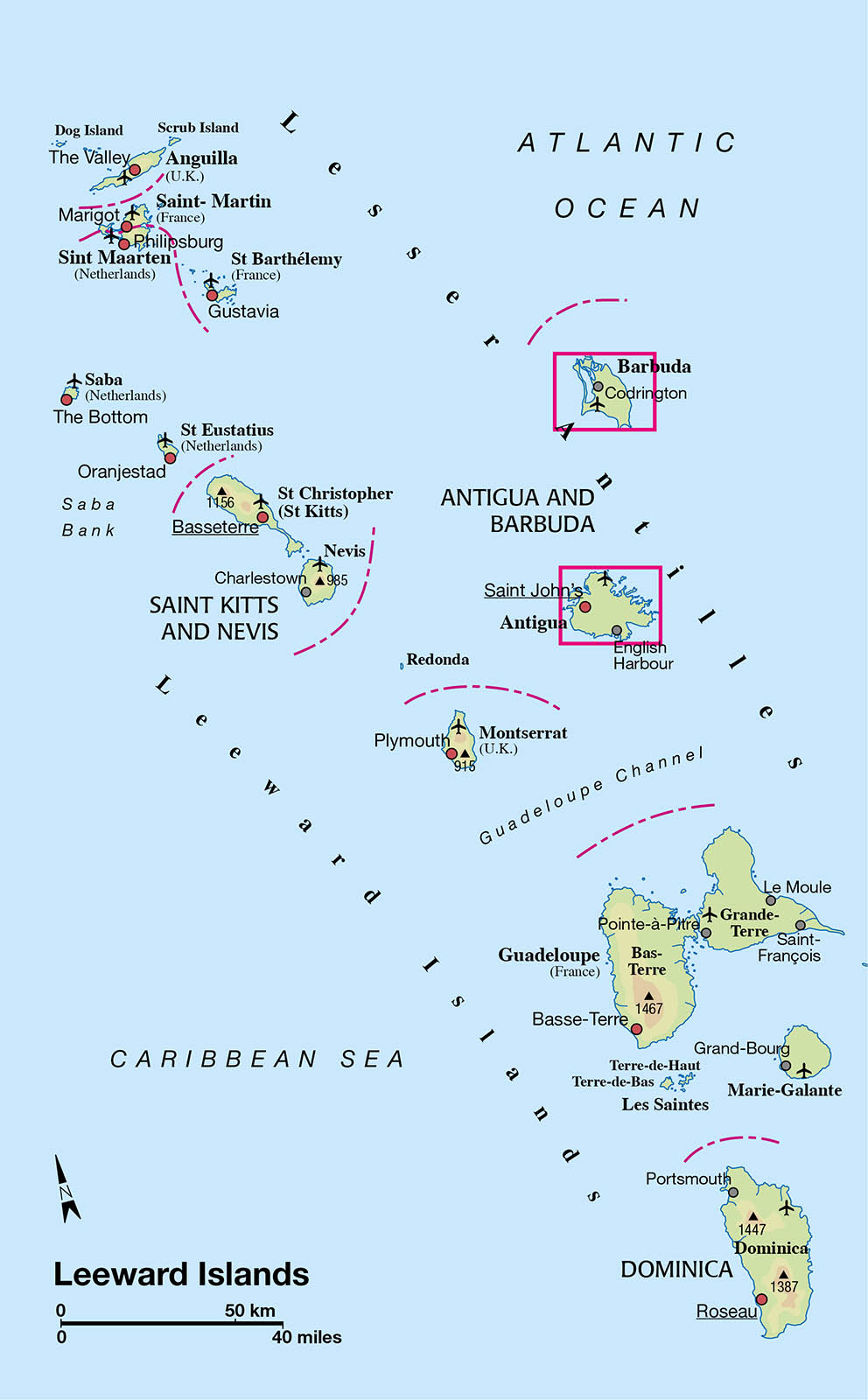
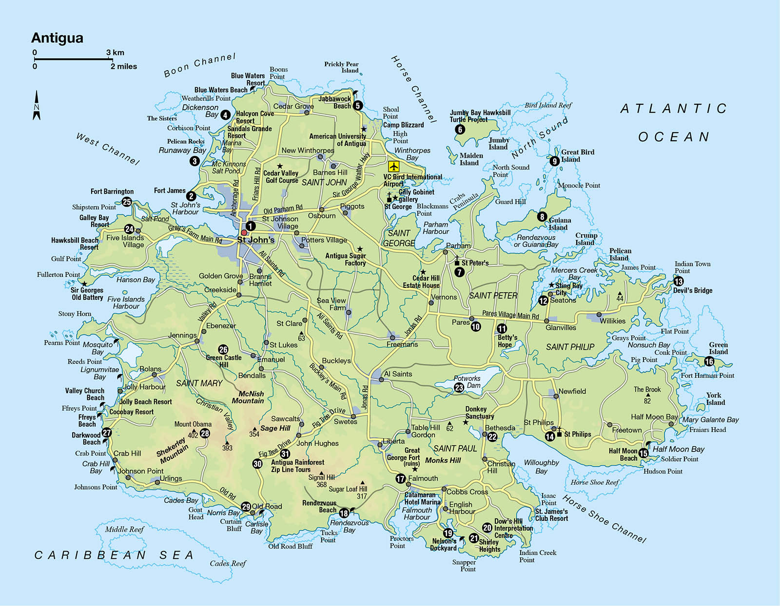
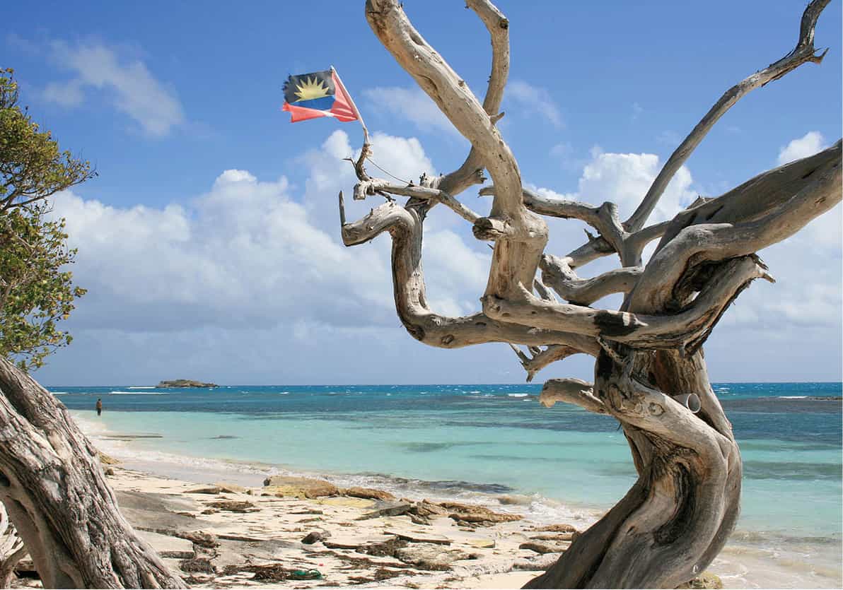
Antigua’s scalloped, irregular coastline is one of its chief delights, so it is no surprise that most of the action takes place on or near the water. Fine natural harbours have welcomed sailors to the island for generations, and sailing is big news.
History buffs should make for Nelson’s Dockyard, the world’s only working Georgian dockyard, and visit Shirley Heights to enjoy panoramic views. St John’s is well worth a visit for its colourful waterfront and fine cathedral, while the stunning inland scenery of the rainforest is matched by coastal wonders such as Devil’s Bridge. Just a short ferry ride from Antigua, Barbuda bakes quietly in the sun. Top attractions here are the mind-blowing, pinkish sand beaches, and ornithologists will delight at the frigate bird nesting grounds.
The best way to explore is by taking one of the many organised tours, or by taxi on a ‘round the island’ tour escorted by a local, very informative fun driver.
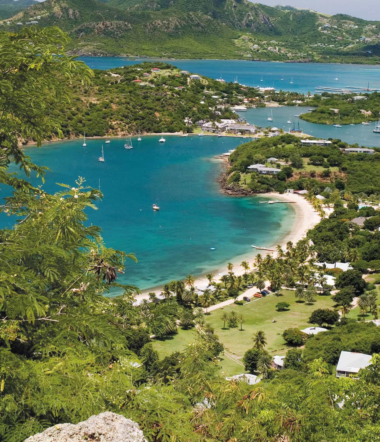
View over English Harbour from Shirley Heights
iStock
St John’s
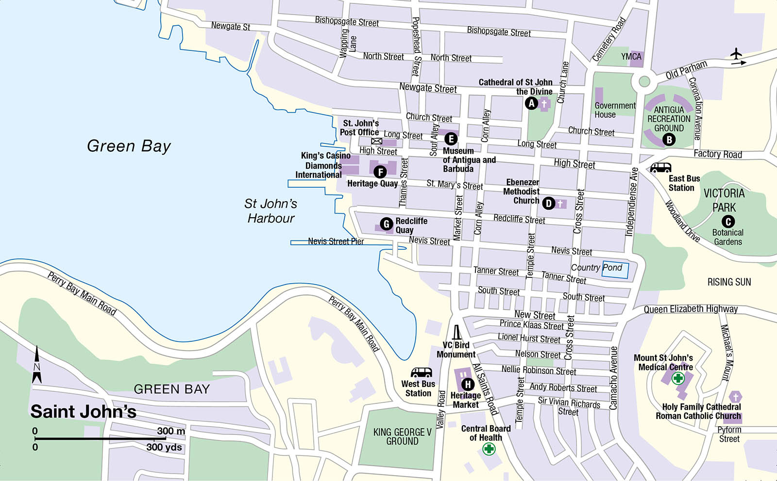
Charmingly time-worn, St John’s 1 [map] is an appealing West Indian town sloping gently back from the waterfront. A melting pot of candy-coloured architecture lines the orderly pattern of streets and narrow alleys. Clapboard buildings with fretwork balconies cluster on the hill below the cathedral, which is the best place to start exploring – unless, of course, you are coming straight off a cruise ship docked in the quay.

St John’s waterfront
Getty Images
Cathedral of St John the Divine
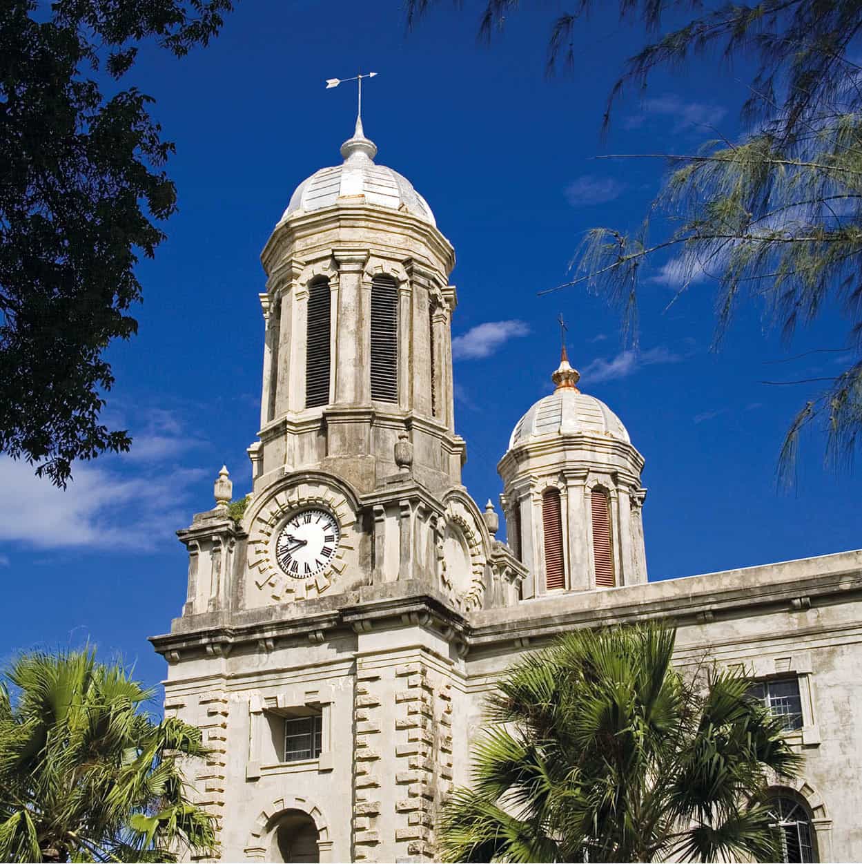
The skyline of St John’s is dominated by the 70ft (21 metres) twin towers of the Cathedral of St John the Divine A [map]. The great parish church, with its walled, shady churchyard, covers a wide block between Newgate and Long streets. The towers, topped with shiny grey cupolas, are impressive, especially for those arriving by sea, and have earned St John’s the reputation as ‘the most imposing of all the cathedrals in the West Indies’.
It is also called ‘a church within a church’, because after the first wooden structure built on this site in 1683–84 was destroyed by fire, and a second stone building severely damaged by the great earthquake in 1834, it was decided that radical measures were needed. Consequently, the present building, completed in 1847 and consecrated on 25 July the following year, was given a pitch pine interior and a stone exterior, as a defence against both fire and earthquake. Subsequent minor tremors and the earthquake of 1974 have taken their toll, however. A great deal of renovation was completed in time for the 150th anniversary in 1998, but improvement works are still ongoing.
The iron gates on the south face of the church are flanked by pillars displaying lead figures of St John the Divine and St John the Baptist. They were taken by HMS Temple in 1756, from a French ship destined for neighbouring Martinique, during the Seven Years’ War between England and France. The cathedral can be entered through these gates, through those on Newgate Street, or via small gates on either side.
The cruciform interior of the church includes an octagonal high altar, made of mahogany, which was presented in 1926 in memory of Robert McDonald, a former chancellor of the diocese. The beautiful stained-glass windows that allow light to flood over the altar portray the Crucifixion of the Lord with the Virgin Mary and St John the Divine. The Blessed Sacrament Chapel is located to the left of the high altar and the War Memorial Chapel is on the right. The inside was opened again in 2018 following restoration, which is ongoing.
Cathedral of St John the Divine
Getty Images
Around Independence Avenue
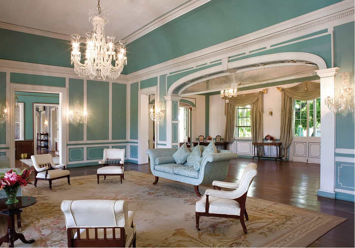
Nearby, east of the cathedral off Independence Avenue, is Government House, the office of the Governor General, the British Crown’s representative on the island. Originally called Parsonage House, due to its proximity to the cathedral, it was owned by a wealthy local man, Thomas Nasbury Kerby. When a suitable official residence was sought for the new governor, Lord Lavington, in 1800, the house was rented by the government because it was ‘detached and pretty’. The following year it was acquired as a permanent home for the island’s governors and additions were made to enlarge and embellish it. The house was extended again in 1860 in preparation for a royal visit by Prince Alfred, who was travelling on HMS St George. Government House fell into disrepair over the years, until major renovations were begun in 1996.
The Cenotaph stands at the top of High Street, which runs into Independence Avenue. It is a monument to the Antiguans who died in World War I, and was unveiled in August 1919, almost a year after the war ended. Special services are held here each Remembrance Day to honour those who lost their lives during both the 20th-century world wars.
The Antigua Recreation Ground B [map] on Factory Road, known locally simply as ‘ARG’, was once the prime stadium for all beloved Test matches. Now not much more than a shrine to West Indian Cricketer and local hero Sir Vivian Richards, record breaking moments have enshrined the ARG in Antiguan history. You can still see the roll of honour boards that proudly display who scored a 100 or more runs and those who took five wickets or more in a match. Today, the run-down venue may have been overshadowed by the new Sir Vivian Richards Stadium (for more information, click here), but to the elation of Antiguans, the occasional event is still held at the ARG, helped along by joyous music and entertainment. The annual Carnival celebrations are centred on the Recreation Ground and it is also used for big parades, including the Independence Day Parade on 1 November, celebrating Antigua’s independence.
Inside Government House
Getty Images
On the other side of Factory Road is the Rappaport Centre, an angular white building set in landscaped grounds that houses the National Archives. The centre borders the Botanical Gardens C [map], established in 1893 with the aim of providing a green and open space in the bustling capital and promoting an awareness of the natural environment.
At one time the gardens, which span several acres, were a popular spot but in the 1950s they deteriorated and for some time they were rarely used. Some restoration work was carried out in 1987 by the Botanical Gardens Society, but the society itself declined over the years, and two major hurricanes took their toll on the grounds during the 1990s. Today, the gardens, while partially restored, remain rather neglected.
Despite their slightly lacklustre state, the grounds can provide a wonderful shady spot in which to cool off in the middle of a hot day’s sightseeing or shopping, and there are still some plants worthy of note if you care to explore – look for the majestic zulu tree (Ficus nekbuda), which is nearly 90 years old. There are also specimens of Cuban royal palm (Roystonia regia) and the so-called sausage tree (Kigelia africana), as well as bamboo (Bambusa vulgaris schr.). The lignum vitae tree (Guiacum officinale) can also be found here. It is known locally as ‘iron wood’ because it is extremely hard and was therefore used in many of the sugar mills, the remains of which still dot the island.
Ebenezer Methodist Church
From the Recreation Ground walk down High Street, where busy vendors’ stalls crowd the first stretch of pavements, or the parallel St Mary’s Street, both of which lead to the quays. The latter would take you to Ebenezer Methodist Church D [map], constructed in 1839. Methodist teaching on the island was inspired by a prosperous plantation owner, Nathaniel Gilbert, who was a Speaker in the House of Assembly. Inspired by the preaching of John Wesley (1703–91) in England, he brought the message home to Antigua. The first chapel was built here in 1786, but so popular was Methodism that the congregation quickly outgrew the small building and a larger structure was needed. Unfortunately, the subsequent one was badly damaged in an earthquake in 1843 and again in 1974. On both occasions it was repaired, then in 1982 it was declared a historical landmark and work was carried out to strengthen the structure.
Historical though it may be, the exterior is not architecturally very interesting, and the building is usually only open when services are in progress (Sunday at 8.30am). It is sometimes used for other events and concerts, however, and if you pop in when one is in full swing or being set up, you will find a pleasing, airy interior with a wide wooden gallery running around three sides.
National Museum of Antigua and Barbuda
Getty Images
National Museum
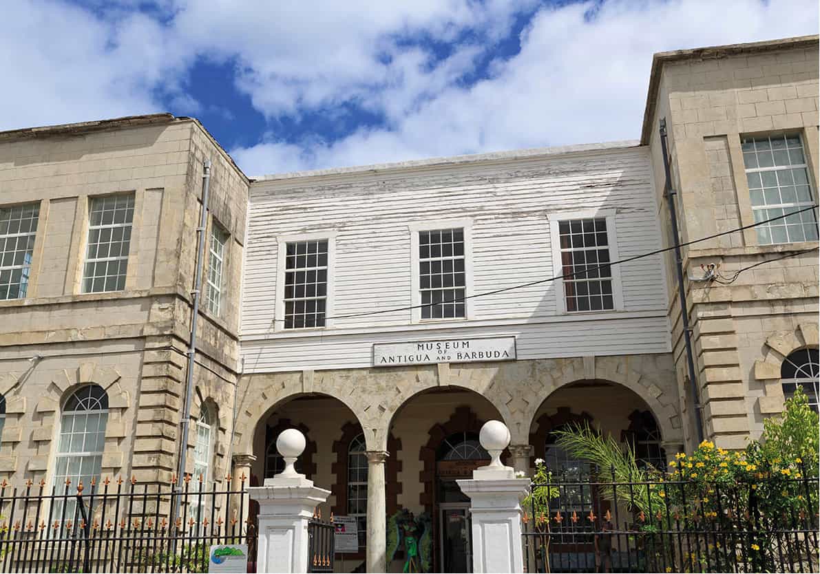
Down Long Street, past the Cathedral of St John the Divine, on the corner of Market Street stands the Museum of Antigua and Barbuda E [map] (tel: 462 4930; www.antiguamuseums.net, Mon–Fri 8.30am–4.30pm, Sat 10am–2pm). The stone building, which was originally St John’s Old Court House, was constructed in 1747 on the site of the first city market, and is the oldest building still in use in the city. It was designed by an English-born architect, Peter Harrison, and financed by a tax levied on local slave owners. The court of justice was held on the ground floor of the building and the upper floor was used as the Council and Assembly meeting room.
Established in 1985, the Historical and Archaeological Society of Antigua and Barbuda operate the museum. The fusty, old-fashioned layout tells the story of the island, from its geological birth to political independence in 1981.
There is a fine collection of Amerindian (mostly Arawak) artefacts, brought from various sites all over the island, and displays on sugar production – including a steam engine – and on the mid-19th century emancipation of slaves. Also on display is the cricket bat that belonged to Viv Richards; in 1986 he used the revered bat to score the fastest Test match century in history.
Cruise ships crowds
With a steady increase in cruise ships calling at St John’s, if possible, try to avoid the days they are in town. Not only are there crowds but the restaurants and shops often hike their prices when the passengers overwhelm the town.

Cruise ship moored at Heritage Quay
Getty Images
The waterfront
At the lower end of High Street is the former Bank of Antigua in two solid, pillared edifices on the left. On the right stands a small bronze statue of Vere C Bird, known as ‘Papa Bird’, the first prime minister and the most dominant figure in the island’s political history (for more information, click here).
The compact waterfront is the main focal point of town, and approaching from this direction King’s Casino (for more information, click here) will be your first introduction to Heritage Quay F [map]. The casino opened in 1988 and was built to cater to the needs of passengers from the cruise ships that call at the modern, 900ft (274-metre) dock that was constructed in St John’s Harbour in 1988. Heritage Quay (for more information, click here), the adjoining duty-free shopping complex, grew up around the same time. When ships are in port, there is sometimes live steel band music playing here.
Moravian memorial
At the end of High Street, in front of the casino, is the Westerby Memorial Fountain. It commemorates George Wall Westerby, Bishop of Moravia, who died in 1888 after ‘labouring faithfully in the West Indies for nearly 50 years’, as the inscription reads.
The Moravian sect began in Bohemia in the 15th century, resurfaced in Moravia in the 18th century, then spread to the Americas, reaching Antigua in 1765. The mission was to take the gospel to all oppressed people and provide both primary and secondary education for slaves. There are 11 Moravian churches on Antigua, all well attended by the devout islanders.
Next door to the dock, encompassing a whole block between St Mary’s and Redcliffe streets, is the purpose-built, ochre-coloured Vendors’ Mall (for more information, click here). Before the modern mall was built in 2001, stallholders occupied little wooden shacks that blocked access to nearby streets. Some of the lively hustle and bustle of a West Indian market has been retained in this more organised setting.
The waterfront boardwalk leads into the beautifully restored Redcliffe Quay G [map] (for more information, click here), on Redcliffe Street. This is one of the oldest parts of St John’s and in 1991 was awarded a prestigious preservation award, recognising it as an outstanding example of the rehabilitation of authentic West Indian Georgian architecture. This used to be at the very heart of the flourishing coffee, rum, sugar and slave trade between Europe, Africa and the island. It’s an attractive development, with the well-restored, 17th- and 18th-century dockside warehouses converted into shops, restaurants and cafés, enhanced by vivid climbing plants and shady palm trees, and it has the atmosphere of a small island village.
South of the quay is a third dock, the Nevis Street Pier, which has increased the port’s capacity for even more cruise ships to berth here.
From Redcliffe Street, turn right to find the Heritage Market H [map] (for more information, click here), at the south end of Market Street. This vibrant vegetable and fruit market used to be held in the street, but is now housed in a high-ceilinged, purpose-built structure. Next door, in a smaller but otherwise identical building, is the Craft Market, selling locally made souvenirs such as banana leaf hats, rag dolls, carvings and beads. Right outside Heritage Market is a huge, audacious statue in honour of Vere C Bird, painted in colours that are vivid even for this tropical town.

Fort James
Getty Images
The north coast
Apart from the fort and two superb beaches, this coast does not have a great deal in the way of attractions, but there are some interesting corners and byways. For nature lovers the off-shore islands provide an engaging excursion, usually visited by boat or catamaran trips that pick up visitors from St John’s or from hotels all over the island.
Fort James
North of St John’s the road curves round towards Fort Bay and follows the sweep of a pleasant white sand strip, which has escaped the cruise ship invasions. It is very popular with local families at weekends and on public holidays, as it is the closest good beach to town. There are lots of refreshment, barbecue and souvenir stalls, in season, and loud music at weekends. In the early morning it is peaceful, with only locals standing chatting in the clear water.
From the beach, paths have been laid out among the trees leading to the remains of Fort James 2 [map] (always open). On a site originally called St John’s Point, the fort was built, along with Fort Barrington (for more information, click here), to protect the entrance to the harbour from enemy ships and pirate incursions. The foundations were laid in the 1670s, a few years after the French had sacked St John’s, but the walls did not go up until early in the 18th century. When it was completed it had 17 cannons, which were increased to 36 during the American War of Independence (1775–83) at the time that Britain got very edgy about the islands. The fort never engaged in battle but it must have been a successful deterrent.
The site is sadly neglected but 10 of the huge cannon remain, as do some of the original walls. Apart from the magnificent view, it is the size and the site itself that are the most impressive, and the battery of great guns facing out to sea.
Masons’ stone
A plaque on the wall of Fort James states that the first stone was laid by William Isaac Matthew, the Provincial Grand Master of the Three Lodges of the Free and Accepted Masons of Antigua.
The Blue Waters Resort wedding gazebo
Blue Waters Resort
Runaway and Dickenson Bays
Some of the Runaway Bay 3 [map] beach was eroded by Hurricane Luís in 1995, but it is still a very lovely bay with sun loungers and umbrellas to rent and a beach bar. The beach and sea views attract a sizeable number of visitors, particularly when the cruise ships are in. Just inland, McKinnon’s Salt Pond parallels the road and the beach and is a good place for birdwatching – sandpipers, terns, pelicans, herons and West Indian whistling ducks can all be seen here.
The coast road to Dickenson Bay takes you via Corbison Point, which divides the two bays. Set high on a neat green bluff is a conical stone structure that at first sight could be a renovated sugar mill, but is in fact the remains of an 18th-century British fort. Fragments of Amerindian pottery have been found on this site, but no traces of any early civilisation are visible.
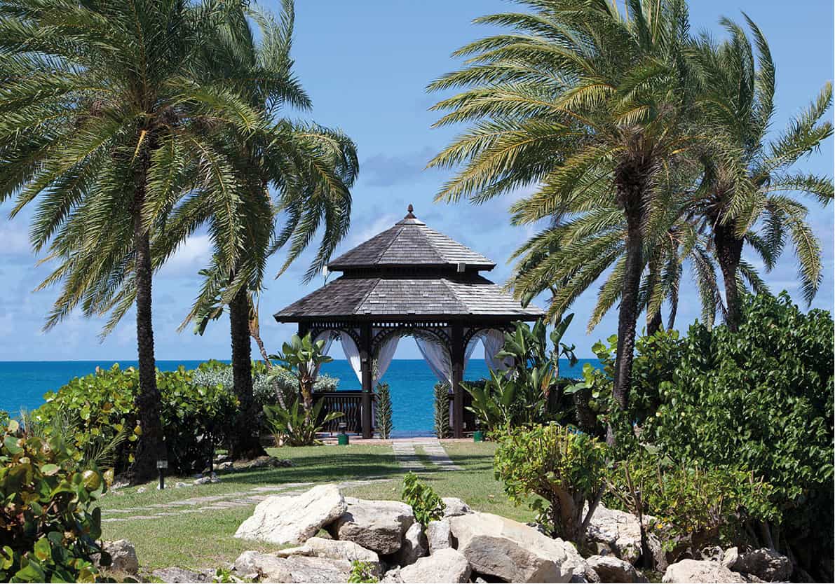
Running between Corbison Point and Weatherills Point, the mile-long sweep of Dickenson Bay 4 [map] beach is almost unbelievably white, its waters stunningly turquoise-blue. Windsurfers and water-skiers love it, but there is also a protected swimming area so that they don’t encroach on those who prefer to laze or swim. This is one of the most heavily populated tourist areas on the island, so it can get busy at the height of the season. The two main hotel-resorts here are the couples-only Sandals Grande Resort and the family-friendly Halcyon Cove Resort (for more information, click here). A short distance north of here is the Blue Waters Resort (for more information, click here), at Soldier Point; it is well known as a venue for weddings – the latticed wedding gazebo can be seen on the clifftop.
Jabbawock Beach
Antigua & Barbuda Tourism Authority
Around Jabbawock Beach
Further around the coast is Beggars Point and Jabbawock Beach 5 [map]. It is a totally natural spot that is popular with locals and for windsurfing and kitesurfing. From both the point and the beach you can see Prickly Pear Island offshore, a five-minute boat ride that’s extremely popular for daytrips.
Between Jabbawock Beach and Camp Blizzard stands the campus of the American University of Antigua (AUA), the most modern campus in the Caribbean. AUA provides a comprehensive modern learning facility for students aspiring to be doctors in the US and Canada; and all just footsteps from the beach!
Just south of here is the Antigua and Barbuda Defence Force’s Camp Blizzard, housed in what was the US Naval Base. The US leased the land from 1941 until the early 1990s when they handed it back to the Antiguan Government. On the right of the gated entrance to the military camp there is an unpaved road that leads to The Pottery (Dutchman’s Bay; tel: 562 1264; www.sarahfullerpottery.com; Mon–Fri 9am–3pm). Sarah Fuller makes and sells individually designed pottery using local clay and Caribbean blue glazes. The terracotta clay is dug in the central plains of the island, air-dried and stored until it is needed. Many of the designs reflect the island’s colourful history and indigenous features – sugar mills, pineapples and exotic blooms.
Jumby Bay Island
Along the airport skirting road, with Winthorpes Bay to the left, is the Jumby Bay ferry dock, which is the only access to the luxurious Jumby Bay Resort (for more information, click here). The island is in fact only 1 mile (2km) end to end and with less than a 4-mile (6km) circumference.
Jumby Bay is home to one of the greatest natural wonders on Antigua, the hawksbill turtle. Among the most endangered species of sea turtles, the Atlantic hawksbill (Eretmochelys imbricata) has always been prized for its beautiful shell and the jewellery that is produced from it. In 1987 the Jumby Bay Hawksbill Turtle Project 6 [map] (www.jbhp.org) was instigated, as people became aware of the valuable nesting ground here. This project is funded by the Jumby Bay Island Company and by private donations, along with assistance from the Odum’s School of Ecology at the University of Georgia, which organises and co-ordinates the project.
According to the Wider Caribbean Sea Turtle Recovery Team and Conservation Network (WIDECAST), this nesting site is one of the most important and best-studied rookeries of hawksbill turtles in the entire Caribbean region.
The team seeks to increase public awareness of sea turtles regionally and internationally through school visits and educational turtle watches for both residents and tourists. Young guests at Jumby Bay Resort can experience a turtle nesting at Pasture Bay and release hatchlings into the sea. Supervised turtle watching trips are available to all visitors between June and November by contacting the Environmental Awareness Group (tel: 462 6236; www.eagantigua.org). This is one of several eco projects undertaken by the EAG across Antigua and Barbuda.
Failed plan
Rats have always been a problem on Antigua. Centuries ago, plantation owners introduced the mongoose to kill off rats that were attacking the sugar cane. Unfortunately, the plan didn’t work and the island now has a surplus of mongoose too. The long, low creatures are often seen scuttling across the roads.
Fitches Creek
South of the airport, Fitches Creek is an affluent neighbourhood on Fitches Creek Bay. Spreading out from the traditional village street are roads dotted with smart villas, their gardens overflowing with flowering trees and palms. St George’s Church is located in a splendid setting overlooking Fitches Creek Bay. An Anglican church built in 1687 and remodelled some 50 years later, it was badly damaged by Hurricane Luís in 1995 but now restored. Dawn’s Nursery, which has been operating since 1987, is down a left turn past the church. Hibiscus, bougainvillaea, orchids and a wide selection of colourful tropical plants are on sale here, including indigenous species such as calabash, the silk cotton tree and passion fruit. Just north of the church, local artist Gilly Gobinet’s gallery (www.gillygobinet.com; Nov–June Mon–Fri 9am–1pm) is located in her charming, secluded seafront property. Her original paintings, both figurative and abstract, are showcased in beautiful surroundings with stunning views over the water. She has a studio on the premises where you can see her at work and perhaps enjoy a drink in the courtyard.
Stained glass in Parham’s St Peter’s Church
Getty Images

Kitesurfer in action
Antigua & Barbuda Tourism Authority
Parham
Southeast towards Parham, the mill towers of Parham Hill Estate (a private estate not open to visitors) can be seen on the right, as can the tall, graceful royal palms surrounding the house. Royal palms were once associated with all the colonial Great Houses on the Caribbean islands, usually lining the driveways. Parham Hill is one of Antigua’s finest remaining examples. Built in 1689 for the wealthy Tudway family (who at one time also owned Guiana Island), it stayed in the family until the late 19th century. The house has been lovingly restored and repaired after damage by several hurricanes.
The colonial village of Parham features one prominent building, the Anglican St Peter’s Church 7 [map], which was the first building in the village to be lit by electricity, in 1920. The present church is the third to be built on this site; the first, constructed in 1711, was a wooden structure that was burned to the ground, leaving only a walled graveyard in the open countryside. Interesting gravestones from some of the old island families remain in the overgrown churchyard. The second church, built in 1754, was dismantled to make way for the present one, built in 1840.
This light, airy building is octagonal in shape and features a beautiful, ribbed, ship’s keel ceiling and some of the original stucco work. It is one of the finest examples of Georgian colonial architecture in the Caribbean. The roof was damaged during Hurricane Hugo in 1989 and underwent major repairs in time for the 150th anniversary of its dedication, on 29 June 1990.
There are some pretty wooden houses and refreshment stalls in the village of Parham, but there is not much more. It was the first British settlement on the island and the home of one of the early British governors. Because of this, some people claim that it was the original capital, but this is not the case. Parham’s sheltered port, the first on the island, flourished with the sugar trade, but today it only offers anchorage for a few pleasure yachts and a small fleet of fishing boats.
The North Sound waters are a snorkelling paradise
Antigua & Barbuda Tourism Authority
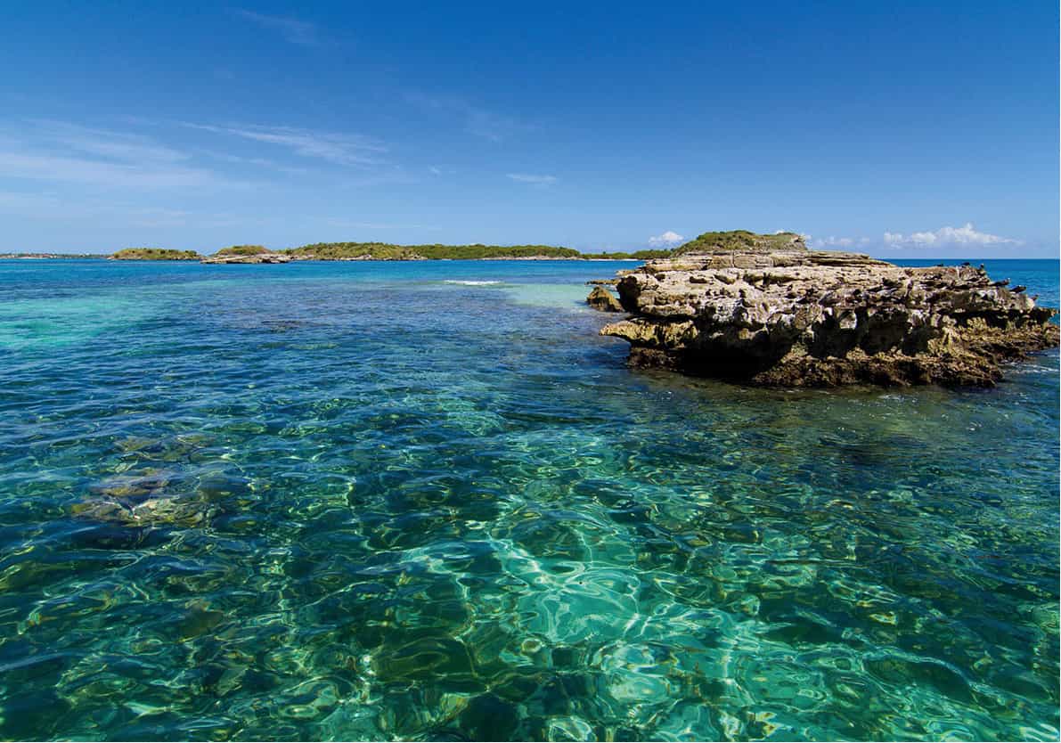
Crabs Peninsula and offshore islands
A little further on around the coast from Parham, the low, flat stretch of Crabs Peninsula comes to an abrupt end at the Antigua Defence Force military installation. Located on Crabs Peninsula is the government-owned Water Desalination Plant, built in 1987. Although most visitors will not get too excited about this, it is worth remembering that on an island that suffers from severe water shortages, it is desalination plants that enable hotels to provide warm showers and flushing toilets.
From the east of Crabs Peninsula, it is easy to see the islands that lie in North Sound. The largest is Guiana Island, separated from the mainland by The Narrows, a strip of water about 400ft (120 metres) across. They are all uninhabited and can be reached by boat. Small private charters can be arranged but most people see them from boat or catamaran trips around Antigua’s coast (for more information, click here).
The North Sound islands offer a rare opportunity to appreciate the glories of nature, both above and beneath the water. As you glide along in a boat you can look down and see small stingrays below. Some of the endangered species found in these islands include the West Indian whistling duck (Dendrocygna arborea), the tropical mocking bird (Mimus gilvus), the Antiguan ground lizard (Ameiva griswoldi) the red-billed tropicbird (Phaethon aetherus) and the hawksbill turtle (Eretmochelys imbricate).
Guiana Island 8 [map] is believed to have been first occupied as early as 2,000 BC by Amerindians, but it was named after the English settlers who came here from Guiana (now Surinam) when it was occupied by the Dutch after the Treaty of Breda in 1667 and they were forced to leave. Sugar cane, cotton and staple provisions were grown by the English settlers in the early years, and the island was later taken over by Charles Tudway of Parham Hill. In 1812, it passed into the hands of Sir William Codrington, a member of one of Antigua’s oldest landowning families, and it remained in the family until 1929.
Under the later ownership of Guiana Island Farms, a Welsh couple, Taffy and Bonnie Bufton, were brought to Antigua to manage the land, on which the main crop was cotton. When this was deemed unprofitable, the island was allowed to revert to nature and the Buftons remained as caretakers, looking after a herd of merino sheep, whistling ducks (now an endangered species on Antigua) and a herd of fallow deer. There were at least 100 deer in the herd, some so tame they would eat from the Buftons’ hands. Despite this, plans for a hotel development were proposed and the Buftons forced to leave. Mr Bufton died soon afterwards, but his wife moved into accommodation provided by the government.
Sadly, many of the deer disappeared. Occasionally fresh deer tracks indicate that some are still living there, but no one knows how many. The hotel development never took place and Guiana was left to go wild. The newly elected Antiguan government, however, signed an agreement in June 2014, just days after coming to power, with Chinese investors to build a major new development on the island and neighbouring Crump Island. Although ground has been broken, there is still strong opposition against the development, which if completed could comprise a golf resort, several five-star hotels, residential units, a casino and a marina, all enhanced by the island’s beautiful beaches.
Deer legacy
Fallow deer were introduced to Guiana Island by the Codringtons in the 1730s to provide meat for their plantation workers. Their likeness can be found on the Antiguan coat of arms.
Hell’s Gate Island’s spectacular coral archway
Antigua & Barbuda Tourism Authority
Great Bird Island 9 [map] lies to the north and is the next largest and the most popular for local people and visitors on day trips. There are two beautiful white beaches, on opposite sides of the island, and patches of coral reef surrounding it that make it a snorkelling paradise.
Great Bird is home to the red-billed tropicbirds, which nest on the cliffs on the eastern side of the island between December and June and are seen taking advantage of the wind currents as they fly in search of fish. They are easily identified by their flowing tail streamers, which are about half the length of the adult’s body. Sometimes, however, their tail feathers are plucked off by aggressive frigate birds, which you will also see overhead.
Antiguan racer
Great Bird Island hosts what is believed to be the world’s rarest snake. The Antiguan racer (Alsophis antiguae) is harmless and is being conserved by the Antiguan Racer Conservation Project (www.antiguanracer.org), whose mission is to conserve threatened coastal and marine species as well as this critically endangered reptile. When the project began in 1995, only 50 snakes were found but by 2014 their numbers swelled to around 1,000, so efforts are paying off. A major factor was removing rats from the island. The grey-blue females are slightly larger than the silvery-tan males, reaching just over 3ft (1 metre). Primarily feeding on lizards, the snakes are active in the early morning and late afternoon and often keep out of sight during the heat of the day. Those working on the project have now introduced the racer to several other local uninhabited islands.
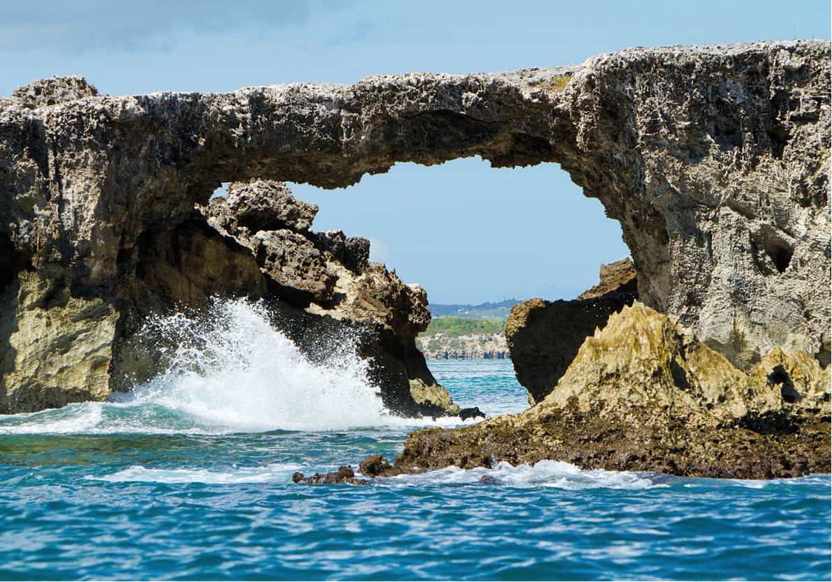
Tiny Hell’s Gate Island is especially interesting as it boasts a spectacular 20ft (6-metre) coral archway, formed by erosion. Just under the arch is a small pool with a sandy beach forming a natural swimming pool – you can swim here if the sea isn’t too rough. It is said the island gained its name because the waters are only a few feet deep on one side of the arch, but plunge to great depths on the other side – almost down to hell. A number of rare birds nest on this island, including the brown noddy tern (Anous stolidus) and Zenaida doves (Zenaida aurita).
Despite its name, Rabbit Island is known not for its rabbits, but for a large resident population of nesting brown pelicans (Pelecanus occidentalis) living on the western side. There probably isn’t a bird that gives more pleasure to the observer than the pelican as it glides soundlessly down to catch a fish. From a protective distance on a boat off Rabbit Island, the pelicans can be seen tending their nests, feeding their young and pecking at neighbours. Pelicans nest in colonies and the nest space is determined by the distance that the bird can stretch towards it neighbour. Two to four eggs are laid at a time and both parents share the task of sitting on them until they hatch.
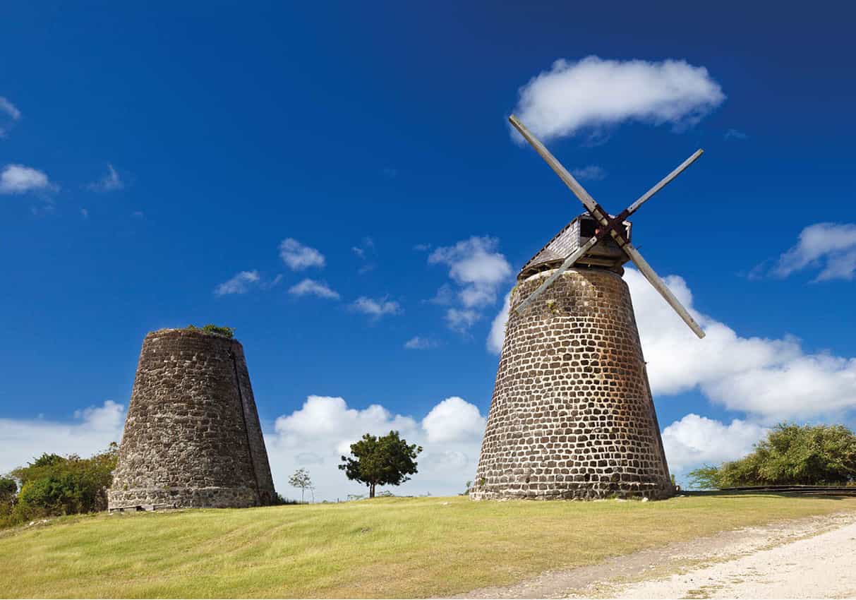
The twin windmills at Betty’s Hope
iStock
East of the island
The east of Antigua is the least developed part of the island. Most of the coastline lies along the rough exposed Atlantic with breezes blowing in directly from Africa. There are few hotels but numerous beautiful beaches, uninhabited islands, a coastline fringed by mangroves and one of Antigua’s most interesting historical sites.
Betty’s Hope
A few miles inland, the village of Pares ) [map] is a good place to start exploring the east side of the island. Along the roadside here you may see sweetcorn being roasted over a coal fire at open-air stalls. This Antiguan speciality has a crunchy, nutty texture and is well worth sampling whilst here.
Just east of Pares village, a marked dirt road leads to Betty’s Hope ! [map] (tel: 462 1469; Mon and Wed–Sat 10am–4pm, opening times are somewhat erratic). This was Antigua’s pioneer sugar plantation; established in the 1650s by Governor Christopher Keynall. It was one of the most prosperous plantations and flourished (thanks to slave labour), for over 250 years. The estate was taken over by the Codrington family, who already had other plantations on Barbados. Christopher Codrington was Governor General of the Leeward Islands from 1700 to 1704, and the family owned nine other plantations in Antigua during the 18th century.
With the decline of the sugar trade the estate was allowed to fall into complete disrepair and many of the stones in the Great House were removed for use in local buildings. However, in 1990, the value of this site was realised, and a conservation project was initiated.
Part of the former estate has been allocated as a heritage site, and a museum and visitor centre occupy the former cotton house storeroom. One unique feature of Betty’s Hope is that it had twin windmills, one of which has been successfully restored, complete with sails, using some machinery and artefacts gathered from other ruined mills on the island. On special occasions it can be seen in operation but even when not working it is still an impressive sight.
Perhaps more impressive – certainly more moving – is the brief, illustrated history of slavery described in the museum. This is one of the best places in Antigua to gain an insight into the sugar industry that made the island landowners so wealthy, and the slave trade that made it possible.
Recognition
Betty’s Hope was recognised by Unesco and awarded a grant in 1994. It received the 1996 Ecotourism Award for preserving the island’s cultural, agricultural and industrial heritage.
The east coast
North of Betty’s Hope, on one of the east coast’s many ragged peninsulas, Seatons @ [map] is a pretty village that straggles downhill towards the sea. It used to be a much bigger place but in the 1950s, after a severe hurricane, many villagers moved to Glanvilles (a short distance east along the main road) and founded a new village. Seatons used to live by fishing, but many of the fishermen now work in the tourist industry.
A scenic five-minute speedboat ride from Seatons will whisk you off to Stingray City (tel: 562 7297; www.stingraycityantigua.com), a shallow stingray pool with a white-sand bottom surrounded by beautiful coral reef where visitors can swim with native stingrays, spiny lobsters and other marine life.
The second attraction in Seatons is the half-day ocean-kayak trip run by Paddles (tel: 463 1944; www.antiguapaddles.com). This is a well-run, husband and wife operation that takes small groups of visitors on a motor boat from Mercers Creek to the near offshore islands within the North Sound Marine Park. There they propel their kayaks between the tiny islands, stopping every so often for an informative talk on the ecology of the mangrove vegetation that surrounds them. This is the habitat of shy turtles, stingray, starfish, parrot fish and a host of tropical birds. When thoroughly exhausted, the party gets back on the launch and are taken to Great Bird Island for a short hike to the top, then they are kitted out with snorkels for a spot of exploration around the coral reef or a swim off the tiny beach. After that, it’s back to base for their famous nutmeg rum punch and banana bread on the patio.
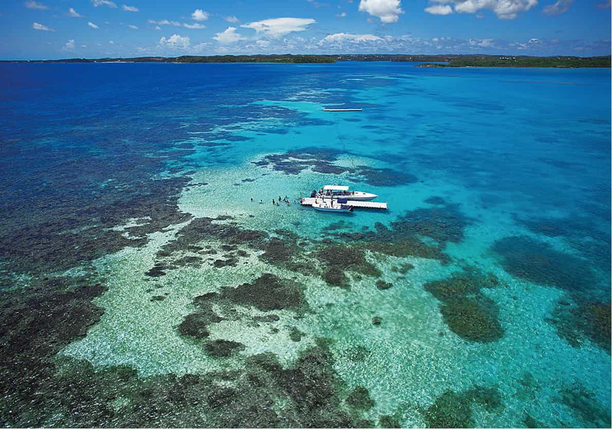
Stingray City teems with marine life
Antigua & Barbuda Tourism Authority
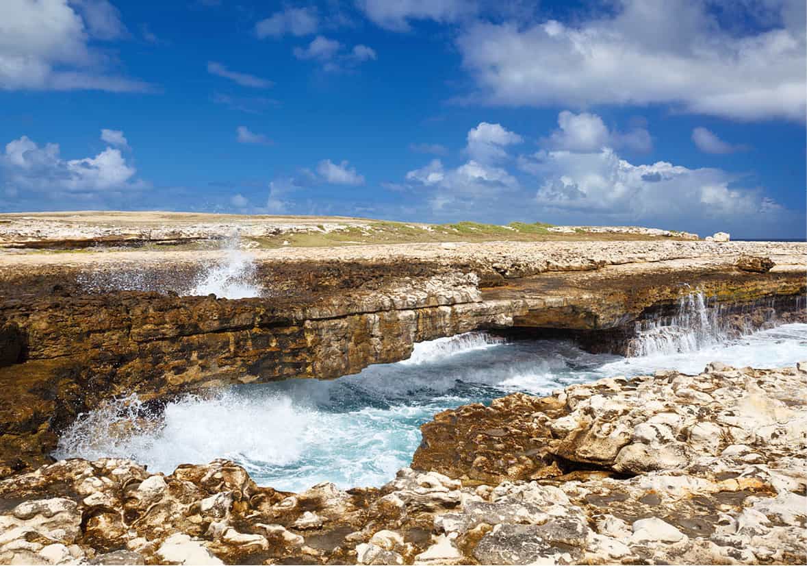
Devil’s Bridge
iStock
Devil’s Bridge
About 3 miles/5km east from the Seatons at Indian Creek you will discover Devil’s Bridge £ [map], a remote, wild site at the end of a narrow promontory. The area is known as Indian Town Point, although no archaeological remains have ever been found here that showed evidence of Indian settlement.
The ‘bridge’ is a remarkable example of wind and salt-water erosion, which has formed a natural arch, approximately 30ft (10 metres) long by 7ft (2 metres) high, carved in the limestone rocks by the waves rolling in from Africa, some 3,000 miles (5,000km) away. There is a blowhole that produces an impressive spout of sea water, rather like that of a whale. The waters surrounding it are always rough, pounding against the coast, and the rougher they are, the more impressive the spout. Do not be tempted to get too close to the ocean or try to walk across the arch as it can be very dangerous, depending on the tide.
Some say Devil’s Bridge gained its name because desperate enslaved Africans from nearby estates would commit suicide by throwing themselves from it into the sea, so local people would say, ‘the devil have to be there’. Legend has it that if you throw two eggs into the water to boil, the devil would keep one and return the other.
St Philips
Back inland, just before the dirt road to Betty’s Hope, a road takes you south through St Philips $ [map]. There isn’t much to the village, but St Philip’s Church is worth a stop. The first parish church was established here in 1690 and then rebuilt in 1830. Hurricane Luís took the roof off this one in 1995, but it has been replaced with green roofing. Judging by its smart new red roof, the house next door most probably suffered a similar fate.
The church is a pleasing, stone-built structure, with tall windows allowing lots of light inside, usually only open for services on Sunday, but the churchyard is a peaceful spot, and the view over Willoughby Bay is not only beautiful, but atmospheric. Even on a calm day it is easy to imagine hurricane force winds whipping across the water, threatening the exposed buildings on the clifftop.
Just past the church, by a small pond in a field on the right, is more evidence of the dangerous power of Hurricane Luís, and the regenerative powers of nature. The 100ft (30-metre) Hurricane Tree refused to give up when it was felled by the winds in 1995. Sprouting fresh green shoots, it still grows in this horizontal position.
The ruins of Montpelier Sugar Factory, reputed to have been one of the finest in the Caribbean in the 1890s, lies on the outskirts of the village, although there is not much to be seen from the road.
Poinciana
Usually known as ‘flamboyant’ or ‘flame trees’, Poinciana are an unforgettable sight often seen along the roadside in full bloom in June and July, covered with dazzling bright red flowers. The tree, a native of Madagascar, is umbrella shaped and offers generous shade. Well adapted to drought, it blooms profusely then loses its leaves during the dry season, appearing almost dead, but as soon as the rains come new growth begins. The seed pods are long (up to 2ft/50cm) and when dry make a distinctive rattle. They are popular as percussion instruments, locally called shack shacks (rattlers). You will see varnished versions of them for sale in souvenir shops throughout the island.

The royal poinciana tree blooms in June and July
Shutterstock
There are breathtaking views of Willoughby Bay from the coast road heading east. A narrow viewing point has been created on the roadside to allow for photo opportunities and to encourage drivers to keep their eyes on the road ahead and avoid a less attractive fate.
Just over 2 miles (3km) northeast of St Philip’s is the lively, well-cared-for village of Freetown. As its name suggests, this was one of the first free villages established on the island after emancipation in 1834 (Freemans and Liberta are two of the others).
Just south of Freetown you will find one of the most beautiful beaches on the island – although there are many other contenders for the title. The crescent-shaped light pink and white sands of Half Moon Beach % [map] rank among the top beaches in the world. At one end there are rolling waves, wonderful for surfing and windsurfing, at the other a coral reef shelters a calm bay, perfect for swimming and sunbathing. The hotel on the south side of the bay, which closed down after Hurricane Luís hit in 1995, is being transformed into a luxury resort and is due to open in 2021. On the path down to the sand you’ll find Beach Bum bar (click here ), serving simple Caribbean food.
For the fit and adventurous, there’s a walk starting just beyond the hotel that will take you along the beach and over the sharp-edged cliffs to Soldier Point where there is a natural coral bridge poised high above the crashing waves. The scenery is spectacular, and you are unlikely to meet another soul along the way. Further north towards Nonsuch Bay, just off the coast is the deserted Green Island ^ [map], which offers white sand beaches waiting to be discovered. It is an ideal spot for snorkelling and a common stop for sea charters and excursions, which can spoil the tranquillity when several arrive at the same time.

Half Moon Beach
iStock
English Harbour area
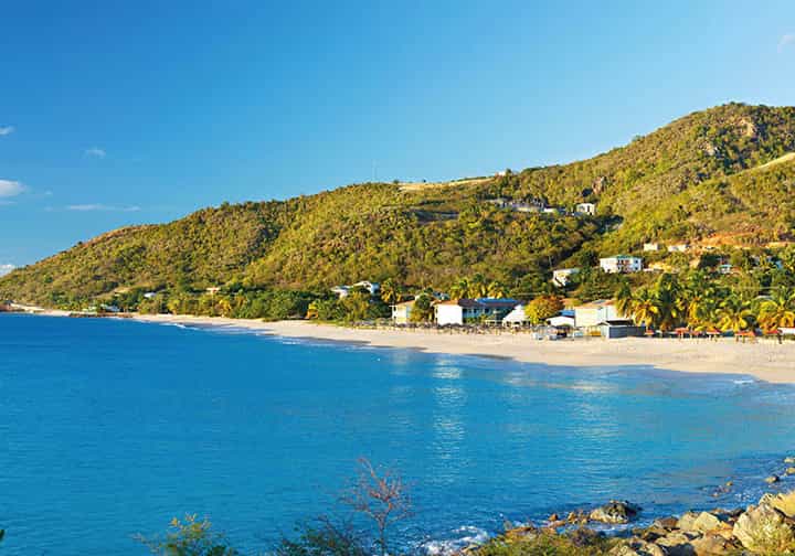
Largely dominated by the old naval dockyard, which was so important in carving out the maritime history of Antigua, this far south peninsula commands the most historical interest. Ruined fortifications occupy a commanding position on high ground from which there are spectacular views over the coastline and English Harbour. Today, the area boasts a leading marina where luxury crafts ply the waters around Falmouth Harbour and many world-class yacht races are held. Here also is one of Antigua’s most glorious beaches, laid out before a lush backdrop of steep hills and forest.

Horseshoe-shaped Falmouth Harbour
Antigua & Barbuda Tourism Authority
Falmouth
Built around a lovely natural harbour, the township of Falmouth & [map] was the first English settlement on the island, but the town is small and unprepossessing today. Horseshoe-shaped Falmouth Harbour has a beautiful hillside backdrop. The marina was built to cater for luxury mega-yachts and there are several docks where craft are moored, spread out across this lovely stretch of water. A walk along the jetty is a draw for anyone interested in sailing or those wishing to spot a gin palace; the marina also hosts the Antigua Sailing Week.
Perched high on Monk’s Hill, watching over Falmouth Harbour, are the remains of Great George Fort. The site was chosen in the 1680s as the perfect location to guard Falmouth from the French, who had recently attacked St Kitts. The work was completed around 1705, but the fort was never engaged in battle. Like many of the historic sites in Antigua, this one is in need of care and conservation.
A diversion west from here to Rendezvous Beach * [map] is well worth the effort. As you drop down to the palm-fringed turquoise waters you will soon realise why this is considered to be one of the most magnificent beaches on the island. A four-wheel drive vehicle is a great way to arrive at this beach, alternatively on horseback from the nearby Spring Hill Riding School (for more information, click here). Since 2014, the bay has been under development and in the near future you may well have to share this once isolated beach with a residential community and boutique hotel.
English Harbour lies further south of Falmouth where you will find Antigua Yacht Club and several bars and restaurants. A narrow road continues to Pigeon Point, with pristine sands and breathtaking views of Falmouth Harbour. For fine dining on the beach, French-owned Catherine’s (for more information, click here) is a must.

The Pitch and Tar Store is now the Admiral’s Inn hotel and restaurant
Shutterstock

The brick pillars are the only remains of the old Boat and Sail Loft at Nelson’s Dockyard
Shutterstock
Nelson’s Dockyard National Park
English Harbour, Antigua’s graceful and evocative historic district, is focused on the 15 sq miles (38 sq km) of Nelson’s Dockyard National Park, a Unesco World Heritage Site. Almost all the park’s other sites of interest overlook the harbour and incorporate Clarence House and Shirley Heights.
Nelson’s Dockyard ( [map] (tel: 481 5021; www.nationalparksantigua.com; daily 8am–6pm; entrance fee includes Shirley Heights and Dow’s Hill Interpretation Centre) is the only operational Georgian naval facility in the world, and has been preserved and beautifully restored as a National Park in 1985. You enter through a covered market area where souvenirs and crafts are on sale and you can buy freshly squeezed fruit juice.
The dockyard dates from 1743, although most of the preserved buildings were constructed towards the end of the 18th century. Its purpose was as a careening station, where British ships were scraped, repaired, and restocked with water and supplies. The harbour on which it sits was originally chosen as a hurricane haven in the 1670s for the ships that protected the West Indian colonies from enemy attack.
Horatio Nelson (neither Lord nor Admiral at the time) was in command here from 1784 to 1787. Nelson’s brief was to enforce the Navigation Acts, which prohibited direct trade between the newly independent states of America and the British colonies. He took his task so seriously that he managed to alienate everyone concerned, and his stay in mosquito-ridden English Harbour – ‘this infernal spot’, he once called it – was not a happy one.
By the late 19th century, steam power had taken over from sail, and the facility gradually became irrelevant, finally closing in 1889. Renovation work began in the 1950s, and the dockyard reopened in 1961. It is once again a working harbour, and one of Antigua’s biggest tourist attractions.

Dockyard Museum
Shutterstock
The first building you come to used to be the Pitch and Tar Store, and is now a hotel and restaurant, Admiral’s Inn (for more information, click here), very popular with the yachting fraternity. Next you come to a rectangle of huge brick pillars; they once formed the lower floor of the Boat and Sail Loft.
As you continue along the main path you will pass a number of buildings (most have helpful information boards outside) before reaching the Admiral’s House, which is now the interesting Dockyard Museum (daily 9am–5pm), with a figurehead of Nelson over the door; a gift shop, library and research centre are also housed here. Although the house was built for the commanding officer (in 1855, long after Nelson’s time), no admiral ever spent a night here. The Admiral’s Kitchen, set back from the museum, is now the Dockyard Bakery, where freshly baked pastries can be purchased.
Trees in the dockyard
Nelson’s Dockyard is well planted with flowering trees and bushes, among them the lignum vitae, known as iron wood because the timber is so hard. It used to be widely used for boat building, and in the construction of sugar mills. The coconut tree (Cocos nucifera), which has the largest seed in the world, is also identified. Next to the Admiral’s House is a tree believed to be more than 200 years old. The sandbox tree was so called because its dried pods were filled with sand and kept on the officers’ desks, where they used it in place of blotting paper to dry wet ink on documents.
The original Copper and Lumber Store, close by, has also become an attractive hotel and restaurant (for more information, click here or click here) and the pub next door is also a good place to eat.
Many buildings now have commercial functions: Dockyard Divers (www.dockyard-divers.com) operates from the Old Guard House; some unique shops and galleries occupy other historic buildings, and here too is a beauty salon. A path behind the Copper and Lumber Store leads around the dinghy dock to Fort Berkeley, on the headland. Only ruins remain, but they are atmospheric, and well worth visiting. The guard house has been restored and the original powder magazine, which had the capacity to store 300 barrels of gunpowder, can be seen. From the fort, which was the first defensive point built to guard English Harbour, and named after Admiral James Berkeley, First Lord of the Admiralty, you get a good sense of what the whole complex was about.
Across the mouth of Galleon Bay, now a haven for some splendid yachts, a chain used to be stretched to prevent small enemy boats entering the harbour. It was joined to Fort Charlotte on the far side, but the latter, destroyed by an earthquake in 1843, is now only identifiable as a pile of rubble.

The old Copper and Lumber Store, now a hotel
Shutterstock
If you are feeling really fit and energetic you could continue up the track (turn off just before Fort Berkeley) to the sparse ruins of Keane’s one-gun battery and the remains of Fort Cuyler, which looks south towards the French island of Guadeloupe. When it was built in 1798 by General Cuyler there were four 32lb (14.5kg) guns, and when one was fired in 1799 the platform sank seven inches (18cm). There are spectacular views from here, and the fort clearly demonstrates the strategic importance of this piece of land.
From Nelson’s Dockyard a narrow road winds uphill to Clarence House (not open to the public). Built for Prince William, Duke of Clarence (1765–1837), it has a superb situation overlooking the harbour. Formerly the residence of the governor-general of Antigua, it fell into disrepair but has been saved by a restoration project. The late Princess Margaret and the Earl of Snowdon spent their honeymoon here in 1960, and Prince William, Duke of Cambridge, stayed here when he served as a midshipman.
Past Clarence House a track to the left leads to Dow’s Hill Interpretation Centre , [map] (daily 9am–5pm but can change seasonally; included in the National Park entrance fee), built with the aid of a grant from the Canadian Government. There is a café and gift shop at the centre and a 15-minute multimedia presentation, which illustrates Antigua’s history with illuminated tableaux and television screens.
The great thing about the Interpretation Centre is its situation. It stands among the ruins of the house built in the 18th century for General Alexander Dow, which was destroyed by the 1843 earthquake. From the belvedere the view over the dockyard, English Harbour and idyllic Galleon Beach is quite spectacular.

Shirley Heights Lookout, a perfect place for a meal with a view
iStock
Shirley Heights
From the Interpretation Centre the road winds uphill along The Ridge to Shirley Heights ⁄ [map]. A left fork takes you to the Blockhouse, on top of Cape Shirley, Antigua’s most southerly point. From here you look down on the palatial house and grounds owned by musician Eric Clapton, and on Indian Creek. In the distance, Mamora Bay and the immense sweep of Willoughby Bay can also be seen from here.
Back on the main track, the first structure you reach is the well-preserved ruin of the Officers’ Quarters, on the right. Opposite them is the military cemetery, where the many victims of yellow fever were buried. A few gravestones and memorials still stand on the blustery clifftop.
The road now comes to an enforced halt at Fort Shirley, named after General Sir Thomas Shirley, governor of the Leeward Islands from 1781–91. One of the ordnance buildings has become Shirley Heights Lookout, a deservedly popular bar and restaurant, famous for its Sunday barbecue, steel bands and reggae (for more information, click here). There is an outdoor seating area at the back, from where the panoramic views are superlative.
Pillars of Hercules
At the foot of the hill on which the Shirley Heights Lookout stands is a striking sandstone formation known as the Pillars of Hercules. The rocks are a challenge to get to by land – there is a strenuous walk from Fort Charlotte at Galleon Beach but you need to keep an eye on the tide – so the best way to see them is from the water.

Snowy egret
iStock
Bethesda to Potworks Dam
The road that runs east from Falmouth Harbour offers a rewarding detour down to Mamora Bay, which marks a southern peninsula with the Caribbean Sea on one side and the Atlantic Ocean on the other; on the edge of which perches the exclusive St James’s Club Resort (for more information, click here). From Mamora Bay, the road meanders along the coast with yet more wonderful views over Willoughby Bay and then turns slightly inland to Christian Hill and Bethesda ¤ [map]. The biblical-sounding village got its name from one of the first schoolrooms opened in the Caribbean for the education of slaves, in May 1813; the name means ‘hallowed’.
Today, Bethesda is more often visited for the nearby Donkey Sanctuary (Mon–Sat 10am–4pm, free but donations appreciated). Located on an unmade road (less than a mile down on the left), the sanctuary offers a permanent home for neglected donkeys. Run by the Antigua and Barbuda Humane Society, it currently shelters more than 150 donkeys and is a very popular attraction for children. Informative and passionate staff will introduce you to the friendly animals and kids are invited to groom them. The Humane Society also offers an ‘Adopt a Donkey’ programme, which provides visitors with a photo of their donkey and an official adoption certificate.
On the northern outskirts of the village is the Bethesda Tamarind tree. It is easy to spot as it is the largest tree beside the road (on the left on a slight curve) and painted white around the base. The tree has a symbolic meaning for Antiguans.
In 1951 a number of workers on the sugar estates went on strike over rates of pay. Union leaders insisted that no work would be done until the matter was resolved, even though the employer stated that he would starve the strikers into submission. The workers and their families suffered enormous hardships and were reduced to living off what natural resources they could harvest from land and sea, but in the end they won the dispute, despite military intervention and imprisonment for some of their leaders. In January 1952 the sugar workers were awarded a 25 percent wage increase and went back to work. The tamarind tree at Bethesda was the site of one of the meetings between the two sides as they attempted to thrash out their differences, and has become a symbol of the workers’ struggle.
Further north the road leads around the eastern side of Potworks Dam ‹ [map]. Potworks Dam is named after an 18th-century pottery owned, like so much else on the island, by the Codrington family. It was officially opened in May 1970, after the need for it had been recognised for some time.
During several periods of severe drought, Potworks has been a life-saver in the past but as limited rainfall increases Potworks Dam has been known to run dry. Shortage of water is a problem on Antigua, one which means that much agricultural land is not being fully utilised and the island cannot be self-sufficient in terms of fresh produce, some of which has to be imported from neighbouring islands. The area attracts a wonderful variety of birdlife and is of great interest to birdwatchers, especially around the western edge.
Birdwatching at Potworks Dam
Among the birds seen at Potworks Dam are the osprey (Pandion haliaetus), the snowy egret (Egretta thula) and the West Indian whistling duck (Dendrocygna arborea).

The beautiful beach at Hawksbill Resort
Rex Resorts/fotoseeker.com
West of the island
The west is the most lush and loveliest part of the island, and the area with the most elevated ground. Its highest point is Mount Obama, formerly known as Boggy Peak, and renamed in 2009 in honour of the US President. It is also the most developed part of the island, with the most resort hotels, renowned for their stunning beaches.
West of St John’s
A short distance outside St John’s, sitting on a piece of land jutting out into the Caribbean Sea, Five Islands Village › [map] is named after five tiny, rocky islands at the other side of the eponymous harbour. This is a large and lively village with plenty of small shops and bar shacks and neatly dressed children on their way to and from school. There was apparently no settlement here at all at the time of emancipation (1834), but by 1842 a village had grown up around a Moravian church.
Beyond Five Islands Village the road to Galley Bay is very rough and in wet weather it is often impassable by car. The road winds uphill to a turning area that provides a panoramic view from Deep Bay to St John’s Harbour, and as far as Dickenson Bay (for more information, click here) in the distance. You may also spot the wreck of the Andes, a cargo ship that sank in 1905, lying in only 20ft (6 metres) of water in Deep Bay. Because it is so shallow, the wreck makes an excellent snorkelling site. The Galley Bay Resort (for more information, click here) is an enchanting hideaway, which occupies 40 acres (16 hectares) of tropical gardens, with a lagoon and bird sanctuary, and a secluded palm-fringed beach.
South of here stands the Hawksbill Resort (for more information, click here). It is a serene, attractive place, with villas and apartments set out in luxuriant grounds. There’s a small pool and several pretty beaches (one clothes optional), with sea kayaks lying invitingly on the white sands. From the beaches you can see, approximately half a mile (1km) offshore, the Hawksbill Rock from which the complex took its name. The large rock does look very much indeed like the head of a hawksbill sea turtle.
Sir George’s Old Battery
For those seeking a challenging hike, the ruins of Sir George’s Old Battery are on Fullerton Point to the south, but they are not easy to reach. The battery is prominently shown on maps of Antigua, but little remains. The location is impressive, though.

Fort Barrington
iStock
Fort Barrington
Back up the coast is the Grand Royal Antiguan Resort (being refurbished under new ownership after years of standing empty), marking the edge of lovely Deep Bay. Standing on a promontory on the far side of Deep Bay, in an area called Goats’ Hill, are the ruins of Fort Barrington fi [map]. You can walk along the beach at Deep Bay to get to Goat Hill and then it is a steep but short scramble up the footpath to the circular remains on the top of the little hill. The first fort was built here in the 1650s to guard St John’s Harbour. Fort James, begun a couple of decades later, stood guard on the other side. The ruins are redolent of the island’s maritime history, and the views from this lonely spot are spectacular, especially at sunset.

Kayaks for rent on Jolly Harbour beach
Robert Harding
Around Green Castle Hill
Inland, about 4 miles (6.5km) south of St John’s, is the 565ft (172 metre) Green Castle Hill fl [map]. This grassy hill is the remnant of an isolated volcano. There are large rocks and boulders, so-called megaliths, scattered around the southwestern summit of the hill, which some like to associate with ancient pagan rites, although there is no evidence to back this up. There is also a large stone plaque at one end of the summit, commemorating Lord Baldwin, Governor of the Leeward Islands from 1947–49, whose ashes are buried beneath it. The climb to the top of Green Castle Hill starts from Emanuel village and takes about 45 minutes, but it is not particularly steep or difficult and the views from the top make it well worth the effort.
On the west side of Green Castle Hill, back on the main road from St John’s, at the village of Ebenezer the 87ft (26 metre) broadcasting and telecommunications antenna installation can be seen on the top of Mount Obama. The next village is Jennings, which began as a small estate owned, in 1749, by Samuel Jennings. Later in the 18th century the acquisitive Codrington family bought the land, but by the time of emancipation in 1834 it had changed owners again. The Moravian church then established a school here and the village of Jennings sprang up around it.
One of the greatest pleasures of visiting these villages, and many others around the island, is the opportunity to witness how the ordinary people of Antigua actually live. Strung out along the road are brightly painted wooden houses, known as chattel houses, a term left over from the days of slavery. In season they are smothered with bougainvillaea, hibiscus and other bright blossoms, while banana palms offer shade outside. Sometimes you have to look closely to distinguish between a house, a shop and a bar.

The beach bar and restaurant on Darkwood Beach
Robert Harding
The Jolly developments
Just outside Jennings at the westernmost point of Antigua, is Pearns Point, now the site of what is considered one of the top real estate developments in the world. It comprises of a low-density, environmentally sensitive construction with seven spectacular beaches.
Further south the landscape opens up and, after there has been some rain, becomes pleasantly verdant. A series of conical, wooded hills and, beyond, some lofty palm trees, announce that you are approaching the coast. The road here passes the Christian Valley Agricultural Station, home to Antigua’s collection of mature fruit trees, on the left and the tiny Caribbean Lighthouse Radio Station on the right, before Bolans village and the large Jolly Beach Resort (for more information, click here) and Jolly Harbour complexes.
The two Jollies initially share a driveway but straight ahead is Jolly Beach, a resort hotel spread along an idyllic beach on Lignum Vitae Bay (named after the hardwood tree) and to the right is Jolly Harbour. The latter has a sheltered harbour, a smart marina, commercial centre with shops, banks and restaurants, and a large Epicurean supermarket, plus an 18-hole golf course and other activities. By the beach is the popular Castaways restaurant, all set among the villas and apartments that are available for sale and rent.
A short distance south is the picturesque, red-roofed Our Lady of the Valley church, which stands opposite a mangrove pond. Here the antics of pelicans, egrets and noisy, long-legged avocets, locally known as darling birds, can provide entertainment from the road, or more comfortably from Valley Church Beach. The beach lies beyond the mangroves, separated by a neatly tended expanse of grass. The only drawback of this idyllic beach is that it can become overcrowded with cruise ship passengers at times.
On a bluff sit the pretty villas of Cocobay Resort (for more information, click here), followed by a succession of gorgeous white beaches. Ffryes Bay is very popular with locals and visitors alike. It offers plenty of parking and is an ideal spot for a picnic or barbecue.
Turner’s Beach enjoys a beautiful setting near Johnson’s Point
iStock
Darkwood Beach
The next beach round is Darkwood Beach ‡ [map], regarded by many as one of the best beaches on Antigua and the setting is beautiful. The only development in the immediate vicinity is a beach bar and restaurant, which has been here since 1975, making it the oldest beach bar on the island. It can get busy and many people choose to bring their own picnic. From Darkwood Beach, and several other spots along here, you can see the neighbouring volcanic island of Montserrat. The floating waterpark just offshore is a hit with kids.
Just south is Turner’s Beach, It’s lively here with seafood restaurants (lobster is a speciality) and local art for sale in a shop across the road. Turner’s Beach Restaurant (for more information, click here), in a pink and green chattel house, is a busy spot during the peak season. Try to avoid visiting on days when the cruise ships are in town as the serenity is spoilt.
Nearby other beach bars and restaurants include Jacqui O’s Beach House (for more information, click here), one of the most popular beach restaurants in Antigua. The place is known for its friendly service, excellent lunches and dinners. OJ’s beach Bar along the same road is also worth a stop (for more information, click here).

Cades Bay Pineapple Station
iStock
Towards Mount Obama
Continuing along the coast, the little village of Urlings has a flourishing fishing community. Off Cades Bay, the longest reef on the island, Cades Reef, ensures calm waters for swimmers and is great for snorkelling. You will notice black pineapples, the national fruit of Antigua, for sale on stalls along the road. These fruit, which are unique to the island, are grown at nearby Cades Bay Pineapple Station. You can see the plantations from the road, and the interesting thing about these pineapples – apart from their colour and especially sweet taste – is that they grow at ground level, with the palm-like fronds sitting on the soil.
From Cades Bay, a road leads towards Mount Obama ° [map], the highest point of the island, at 1,319ft (402 metres), a part of the Shekerley Mountain range. It is now a national park and there are various jungle trails for hiking. Formerly known as Boggy Peak, it was renamed in honour of former US President Barrack Obama. The road up to the summit is only suitable for 4 x 4 vehicles and is not for the faint-hearted; it is very steep and not well maintained. It is possible to walk up and the views from outside the fenced area are pretty stunning.
On the far side of shallow Morris Bay, the exclusive Curtain Bluff Resort (for more information, click here) stands out. One of the most expensive resorts on the island, it has an enviable position, as there are calm and peaceful waters on one side of the bluff, and good surfing waves on the other.
Old Road · [map] is the oldest village on the island, and one of the liveliest. The original settlers of 1632 recognised the advantages of the deep-sheltered Carlisle Bay (now renowned for snorkelling), on which it sits, as it provided them with anchorage safe from storms and pirate attacks (‘road’ was a nautical term for anchorage). St Mary’s church here is the oldest on the island.
The landscape along this stretch of coast has now become far more green and fertile, and the village is a mass of tumbling bougainvillaea, frangipani and poinsettias, as well as bananas and giant ferns. Keep your eyes open for a huge, hollow-trunked silk cotton (kapok) tree (Ceiba pentandra). You may also notice people selling huge conch shells on roadside stalls, along with black pineapples and tropical juice drinks.
Old Road is, unsurprisingly, the oldest village on Antigua
Shutterstock
Fig Tree Drive
The road then turns inland and winds through what is known as Fig Tree Drive º [map]. The first thing to remember is that there are no figs – it is an Antiguan word for bananas. And there are plenty of bananas along here, as well as mangos, guavas and soursops. Also, another large-scale producer of the indigenous black pineapples, Claremont Farms (www.claremontfarms.com), can be found here.
Simply driving along the road gives a taste of this magnificent area of the island, and the only part that is mountainous and covered in truly tropical vegetation. This is Antigua’s rainforest region and as you drive through the lush landscape you see nature in its most natural form.
Just off Fig Tree Drive in Wallings Forest you will find an exciting activity, Antigua Rainforest Zip Line Tours ¡ [map] (tel: 562 6363; www.antiguarainforest.com, Tue–Sat 9am–2pm; pre-booking required), which offer a range of tours involving zip line and rope challenges, aerial walkway bridges, tree houses, scary vertical descents and challenge courses. An exhilarating experience is the forest canopy; suitable for all adrenalin junkies starting as young as four years. Safety is of paramount concern, with helmets and harnesses imperative. There is also a gift shop and café-bar.
For those who prefer to keep their feet on the ground Footsteps Rainforest Hiking Tours (tel: 460 1234; www.hikingantigua.com) offer walks to Wallings dam and reservoir, and a climb up Signal Hill.

Antigua’s rainforest has plenty of trekking trails
Shutterstock
Fig Tree Studio Art Gallery
Situated in the heart of the rainforest in the gardens of artist Sallie Harker, the Fig Tree Studio Art Gallery (tel: 460 1234; www.figtreestudioart.com, Nov–June Mon–Sat 9.30am–5.30pm) is a delightful gallery that showcases original artwork from all over Antigua and the wider Caribbean. You will find paintings evoking the wonderful light and colour of the region, featuring rainforest, seascapes, flora and fauna. There is also superb craftwork, created from the natural environment, using materials such as driftwood and seashells, and plant life picked from the rainforest. Also featured is pottery, hand-blown glass jewellery and a range of items made using materials washed up on the seashore.
Back on Fig Tree Drive is little John Hughes village, and then the village of Swetes. The latter’s chief claim to fame is as the birthplace of the former West Indies fast bowler, Curtley Ambrose. Off to the left, between the two villages, a path leads to Body Ponds, a series of dammed ponds where some peaceful walks can be enjoyed.

Antigua Rainforest Zip Line Tours offers an array of hair-raising activities
Antigua & Barbuda Tourism Authority
A visit to Antigua would not be complete without a trip to its tiny sister island, Barbuda, which is about 62 sq miles (160 sq km) in area and lies some 30 miles (48km) northeast of Antigua. Devastated by Hurricane Irma in September 2017, this island, with its breathtaking coral-fringed, pinkish sands, crystal-clear water and charming leisurely pace of life, is working hard to rebuild and restore it to the beautiful paradise it was.
Irma decimated around 90 percent of the island’s infrastructure with homes, schools, churches, medical facilities and boats destroyed. By early 2018 only about 360 people – the population is around 1,800 – had returned to the island and most were living in make-shift tents or in rough accommodation still without power and running water. By the end of 2018 the first hotels and guesthouses were up and running and tours were departing regularly around the island. Getting there from Antigua is simple either by plane or ferry boat (click here).
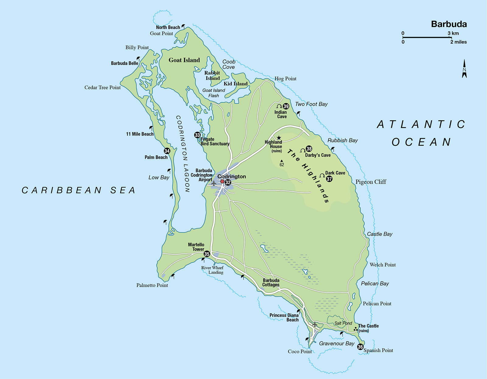
Codrington
A short taxi ride from the ferry dock brings you to the small town of Codrington ™ [map] named after the original English landholders and Barbuda’s main settlement. Most of the island’s population lived here before the 2017 hurricane hit and the settlement is gradually finding its feet again. From here there are organised boat trips to the Codrington Lagoon. You can also take other tours to fabulous beaches and fascinating caves. Cars and bikes are available for hire from Codrington if you prefer to go it alone.
Royal seal of approval
On Barbuda you can follow in the footsteps of the late Princess Diana. Barbuda was a favourite sanctuary of the Princess and the young Princes William and Harry. During the 1990s, she would find solace in the beauty of the island while William and Harry played happily on the powdery soft sands. The young family stayed at the prestigious K-Club Resort, which is now sadly abandoned and in 2019 became the subject of a legal battle over the building of a huge new development. Admired by the locals, the stretch of beach beside the K-Club was renamed ‘Princess Diana Beach’ in her honour during a ceremony on 1 July 2011, the day she would have turned 50 years old.
Frigate Bird Sanctuary
Prior to hurricane Irma a huge colony of frigate birds (Fregata magnificens) could be found on the 12-mile (20km) long Codrington Lagoon west of the town, one of the largest in the world; the lagoon was declared a National Park in 2005. Here, on the eastern shore is the Frigate Bird Sanctuary # [map], once home to more than 10,000 frigate birds, which travel between the Caribbean and the Galápagos Islands. The area was decimated by the 2017 hurricane, destroying the mangrove swamp, home to the nesting birds but gradually the birds are returning to nest in large numbers once more. Some 170 different species of birds visit the lagoon, including ibis, herons and kingfishers.
On the sea-side of the lagoon, Palm Beach ¢ [map] is a magnificent 12-mile (20km) sweep of sand, snowy white in places, pink in others. Heading north is 11-mile Beach and continuing north is the new Barbuda Belle luxury hotel (click here).
Rare birds
Only one chick per pair of frigate birds is hatched, and it remains in the nest for eight to 10 months, one of the longest dependency periods of any bird species. Because of this, they only breed every other year, which is most unusual in the bird world.

Martello Tower
Antigua & Barbuda Tourism Authority
Martello Tower
About 3 miles (5km) south from Codrington, the 56ft (17-metre) Martello Tower ∞ [map] is the most intact part of the ruins of the River Fort. It is a popular spot for weddings. Close to the tower is the River Wharf Landing, where passenger ferries to and from St John’s, load and unload. To the west is Palmetto Point, a popular location for surfers, while heading east along the coast are the eco-friendly Barbuda Cottages (Continuing east is pristine Princess Diana Beach and beyond Coco Point, the site of the luxury Coco Beach Lodge, which was virtually destroyed in the hurricane. The lease has been taken over by the Discovery Land Company who are rebuilding the Barbuda Ocean Club on the site.
Spanish Point
On the southeastern tip of the island lies Spanish Point § [map], where there is one of the most beautiful beaches imaginable – White Bay Beach. Just to the northeast of Spanish Point, shown on most maps as The Castle, the sparse ruins of what was a lookout tower, for defence against attacks by Carib Indians, remain. Its strategic position means that it offers a fabulous view.

Cooling off at Codrington pier
Antigua & Barbuda Tourism Authority
The Highlands
On the east side of the island lies an area called the Highlands – although they are not particularly high. There is little development and the land is wilder. Here, the fallow deer that the Codringtons introduced roam freely, along with wild boar, red-footed tortoises and whistling ducks. There are several caves in the area; some are not accessible and some should not be explored alone, but it is easy to arrange for a guide.
The north shores of Barbuda
Robert Harding
Highland Caves
Dark Cave ¶ [map] is in the middle of the Highlands about 4 miles (7km) east of Codrington, and just south of Darby’s Sinkhole. The cave has a narrow entrance leading to a vast cavern containing pools of water and is a popular habitat for several species of bats.
Darby’s Cave • [map], a sinkhole not far from Rubbish Bay, is reached via a (driveable) dirt track from Codrington, then a 40-minute trek with a guide. The sinkhole has vertical, cliff-like sides and is around 70ft (22 metres) deep and 300ft (92 metres) in diameter. It is surrounded by lush vegetation and a number of tall trees grow in the cave, with their tops at eye level. The path drops precipitously and sunlight filters through the trees and vegetation. There is an abundance of bird life in the dark interior, which resembles a tropical rainforest. A 30ft (9-metre) overhanging cliff has formed stalagmites of calcium carbonate.
Indian Cave ª [map], the most interesting prehistoric site on Barbuda, is located at Two Foot Bay on the northeast coast. From the main entrance there is a short, narrow passage and two small Amerindian petroglyphs (rock drawings) can be seen as the passage opens into another cave where daylight filters in. The Amerindian people used rock drawings to guard their caves and the people in them from evil spirits. These are the only ones known to exist in Antigua or Barbuda. For guides or tours see www.barbudaful.net.

Sunset on the beach
Antigua & Barbuda Tourism Authority
Highland House
The highest point on this flat island, about 3 miles (5km) from Codrington, is just 120ft (37 metres). The ruins of Highland House (known locally as Willybob) can be found here. The house was built at William Codrington’s request in the 1720s, and the overgrown remains of the stables, a water cistern and part of an aqueduct are still visible. The most interesting thing about the place, however, is the view, which is quite spectacular.
Since Hurricane Irma, issues with the government of Antigua over land ownership in Barbuda have resulted in ongoing court cases, and until these are resolved the future for Barbuda, its tourism development and its people cannot be fully determined. Will Barbudans be able to develop their island in the way they wish and not be subject to mass tourism or outside interference? For further information on Barbuda and the latest developments email Claire Frank at barbudaful@gmail.com (www.barbudaful.net).