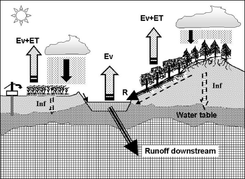
FIGURE 10.1 The water cycle on land. Division of precipitation (water from heaven) between evaporation (Ev) and evapotranspiration (ET), infiltration (Inf), and runoff (R). See also figure 6.1.
EARTH’S WATER, BETWEEN SKY AND SEA
Water falls from the skies, and all open-air creatures large and small depend on its fleeting or prolonged passage over the land. Source and stuff of all life on our planet, water evaporates from the sea to return to the sea. But the water cycle does not follow a single track, and its many ramifications involve byways, bottlenecks, detours, and dead ends. Of the rain falling on land, two-thirds return rapidly to the atmosphere, evaporating in a matter of hours directly from soil and leaf surfaces, more slowly over days or weeks from rivers and lakes (table 6.1 and fig. 6.1). By contrast, water falling as snow may accumulate for months on the plains, for years, centuries, or millennia on high mountains or in the polar zones. Thanks to these slower stages in the race of water to return to the sea, crops growing in dry summer weather can still pump the precipitation of last winter, or even of previous wetter years. And thanks to the prolonged imprisonment of water in polar and mountain ice, twentieth- and 21st-century scientists have been able to study climates of yesteryear, indeed of hundreds of thousands of years ago.
At any moment, the world’s streams and rivers contain only 2,000 cubic kilometers of freshwater (each cubic kilometer being a billion cubic meters or metric tons). But considering the total stream flow of water in all those streams to the sea (about 40,000 cu. km per year; see fig. 6.1), they must empty themselves and be renewed about twenty times every year. On average, water’s “residence time” in rivers and streams is thus about eighteen days. The average can be misleading: fortunately, most rivers do not dry up after a month of drought. Lakes contain some fifty times more of the world’s freshwater than do the rivers themselves, and when, as for the Nile, large lakes store part of the river’s water supply, they provide a reserve for the dry season. In North America, some of the water entering the Saint Lawrence River spends as much as 300 years in the Great Lakes. These inland freshwater seas contain about 60,000 cu. km of water, a substantial share of the total freshwater in liquid form on the Earth’s surface. Similarly, water spends 400 years in the depths of Siberia’s Lake Baikal (23,000 cu. km), before it joins (at 53 cu. km per year) the Angara River flowing to the Arctic Ocean. In western Europe, the 38 cu. km of water in Lake Leman (Lake of Geneva) between France and Switzerland correspond to 250 days of Rhone River flow (partly maintained by the melting of Alpine glaciers); further north, Lake Ladoga with 908 cu. km of freshwater stocks twelve years’ worth of the Neva River, only 74 km long, flowing through the beautiful city of Saint Petersburg (Russia) into the Gulf of Finland.
Lakes play a less important role for most other major rivers; or at least they used to, in an earlier natural state. Dam-building has created reservoirs and artificial lakes along many rivers lacking natural lakes, the aim being in part to regulate the river’s flow, limiting flooding when rainfall is overabundant, providing water for irrigation in dry spells. Such human interference in the natural water cycle began several thousand years ago, but even today, over most of the continents, maintenance of some degree of regularity in stream and river flow depends on underground water gushing or seeping from springs, after months or years in the subsurface water table or deeper aquifers. Some underground water has been there a very long time, thousands of years and more. However, isotopic analyses confirm earlier suspicions that in most of the water table tapped by wells, the water is “meteoric,” i.e., that it is fairly recent water from heaven even if it isn’t yesterday’s rain. The total amount of underground water (several millions of cubic kilometers) acts as a reservoir guaranteeing the outflow of streams and rivers (70,000 cu. km per year), and the underground detour of infiltrated precipitation can take decades, centuries, or even millennia. Wells drilled to irrigate farm or pasture land constitute an artificial shortcut taking underground water back up to the surface and atmosphere. However, even if expediting such water to the surface puts it back in the global above-surface water cycle, there is no reason to expect it to return rapidly to the area of extraction. In most cases, such water is lost for the aquifer from which it comes, either being evaporated or transpired by plants directly to the atmosphere, or running off into streams and rivers flowing to the sea. Pumping such water generally amounts to “mining” a resource that will not be renewed for a century or two at least. When the aquifer is not adequately recharged, such overexploitation may ultimately lead to desertification, as observed in many areas from the western Great Plains (where the Ogallala aquifer is being pumped dry) to the sahels1 north and south of the Sahara Desert.
Average river flow rates and water residence times tell only part of the story; rainfall and snowfall vary from day to day and from place to place. The flow of water depends on widely differing conditions: gradual snowmelt in the plains of the Canadian or Siberian far north, violent local downpours producing flash floods in arid or semiarid areas, cloudbursts and thunderstorms in the tropical jungle or in the vineyards of southern France, showers in St. Louis, drizzle in Seattle, sleet in Boston. Depending on the climate zone, average annual rainfall ranges from practically zero in the Atacama Desert of northern Chile to as much as 3,000 mm (118 in.) in many tropical regions as well as along the temperate-zone Pacific shores of Canada and southern Chile. Moreover, rainfall varies strongly with the seasons in the Tropics, not so much in the temperate zones. Paris usually gets between 400 and 800 mm of rain in a year, between 40 and 70 mm every month. In 1985, a fairly dry year, less than 30 mm fell in February and October, but more than 60 mm in March, May, and June—519 mm altogether. Rainfall was over three times average in July 2000, and very high also from September 2000 to April 2001. New York City usually gets between 800 and 1,400 mm of precipitation in the year, with March, July, and especially August (start of hurricane season!), wetter than other months. But although there is neither a dry season nor a true rainy season in New York, there are dry and wet years. Things are quite different in the Tropics. In Niamey (Niger Republic, in the Sahel zone of Africa), all of 1985 was extremely dry, but 615 mm of rain fell in 1989. Nevertheless, less than 30 mm of rain fell in each month of 1989 except during the rainy season, when July (125 mm), August (303), and September (148) accounted for 93 percent of the year’s total. Moreover, even though annual rainfall at Niamey is about the same as in the forest of Fontainebleau outside Paris, it can’t support the same plant cover, for one thing because it all falls in a few months, for another because with higher year-round temperatures (especially during the dry season), water evaporates much more quickly.
In many regions, a single or maybe two or three events bring practically all the rain that falls in a month. An isolated rainstorm lasting hardly more than an hour may water an area only 10 to 40 miles square. A cyclonic system may remain active for a few days, bringing rain to much bigger areas as it moves, but at any particular place, rain—especially strong rain—may last only a few hours. In Europe, a solitary storm lasting only an hour may soak Amiens (north of Paris) one day, another may drench Brussels, the same day or the next. In southern France, it may not rain often, but when a storm sits for hours over Nîmes or Vaison-la-Romaine, serious flooding results. And when a large cyclonic system spends two days traveling across western Europe from England through Germany and Poland, the duration and intensity of precipitation are not the same in Plymouth (England), Cherbourg, Cologne, or Dresden, and not everyone may feel the same need to use an umbrella. In France, it rains only 10 percent of the time considering every hour; but in an average year in Paris, 75 days have more than 2.5 mm (0.1 in.) of rainfall, while there are 112 days with rain in Brest (Brittany), and only 49 in Nice on the Riviera. In the United States, New York City has 78 rainy days in an average year, Denver 37, Astoria (Oregon) 139, and Yuma (Arizona) only 12. In the east, cyclonic disturbances move up along the Appalachians from Georgia to Vermont, satisfying farmers with welcome water but sometimes feeding floods that wash away stream-side homes, depending on the location and amount of the rain.
In some regions, topography systematically produces rainfall—for example, the Himalayas, the Bismarck Mountains of Papua New Guinea, the Pacific Coast Range of Canada and the northwest United States, the cliffs of the northeast coast of the big island of Hawaii. Elsewhere, however, although rainfall is often highly concentrated, those downpours don’t always drench the same places. Once rain has reached the ground, or once snow melts, the water follows three processes: evaporation (or evapotranspiration) returns water directly to the atmosphere as water vapor, the gas; infiltration takes water down into the soil and subsurface layers, where it helps to regulate flow of water at the surface and at the same time affects the chemical properties of soil; and runoff, water moving mostly horizontally on downward sloping surfaces, collecting liquid water and taking it back to the ocean (fig. 10.1). Rainwater on a ridge or other line dividing the waters may make two (or more) very different journeys, depending on exactly where the raindrops fall. On a map, as well as on the terrain, those lines divide the land surface into watersheds. Provided it does not return directly to the atmosphere, water falling on the watershed will either infiltrate the soil or flow off on the surface; and most of the surface streams of a watershed join together to form bigger and bigger streams partly also supplied with water having seeped underground and out again. From gullies to rills to brooks to rivers, the water runs downhill and the streams run together. Half of the world’s river flow to the sea is carried by the seventy biggest river systems, and seven of these account for more than a fourth of the total: the Amazon, Paraná-La Plata, Congo, Chang Jiang (Yangtze Kiang), Brahmaputra, Ganges, and Mississippi-Missouri (fig. 10.2). In a sense, diverting river water for irrigation constitutes a local delaying action against the concentration of river flow, as it waters the land surfaces near (and not so near) to the river. Irrigation also strongly increases return of water to the atmosphere by way of the evapotranspiration of extended denser plant cover, and by evaporative losses from reservoirs, irrigation canals, and sprinkling.
FIGURE 10.1 The water cycle on land. Division of precipitation (water from heaven) between evaporation (Ev) and evapotranspiration (ET), infiltration (Inf), and runoff (R). See also figure 6.1.
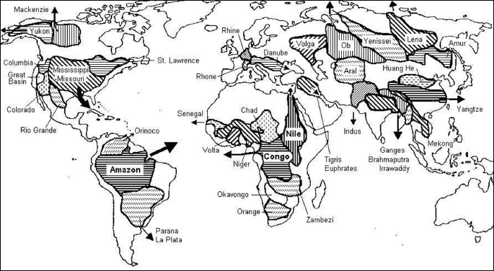
FIGURE 10.2 The great river basins. Note that Lake Chad (Africa), the Okavongo (Botswana, southern Africa), the Great Basin with Utah’s Great Salt Lake, the Caspian Sea (into which flows the Volga), and what’s left of the Aral Sea (into which flow the Syr Darya and the Amur Darya Rivers from Central Asia), all drain large areas but have no outlet to the oceans, losing water essentially by evaporation. By contrast, the very large runoff to the Pacific from Indonesia and New Guinea goes by way of a multitude of streams, none of which drains a large area.
VEGETATION, EVAPOTRANSPIRATION, AND THE SOIL
Plants make up nearly all the living matter on “dry” land, and water makes up the major part of that matter. Although their total water content comprises but a tiny fraction (much less than 1%) of the water available on land surfaces, plants play a key role in the division of water between evaporation on the one hand, and runoff and infiltration on the other. First of all, by way of sunlight-powered photosynthesis, vegetation uses part of the available water, together with carbon dioxide in the air, to make its own organic matter. The plant also needs water, in its sap, to transport other nutrients from the soil to the growing leaves. Oxygen (O2) appears as a by-product of vegetation’s manufacture of organic molecules from water (H2O) and carbon dioxide (CO2), and the exchange of CO2 and oxygen (O2) between the plant and the atmosphere necessarily involves some loss of water to the atmosphere: transpiration (in practice, evapotranspiration, as the transpired water evaporates). Roots constitute water-supply structures with which plants pump from the soil the water that is essential to their growth. The different gases (in particular CO2) exchanged between the plant and the atmosphere pass through other structures, the small openings or pores called stomata distributed on the leaf’s surfaces. The same stomata eliminate excess water pumped by the roots, depending on the temperatures of the leaf and of the air (and on the air’s humidity). As it evaporates, transpired water carries off latent heat, keeping the plant cool. When the soil at the surface is dry, the plant suffers and begins to wilt, and its survival under such stress depends on its ability to pump less easily accessible water deeper down, assuming that any exists.
Plants thus return to the atmosphere some of the water that infiltrates the soil (fig. 10.1); depending on their needs and their root structures, they extract that water from layers as deep as a few feet or sometimes a few meters. In a single day, a linden tree can transpire 500 liters of water, a stand of oak about 30 cubic meters per hectare (12 tons per acre). The subsurface water can only evaporate once it is brought to the surface, and vegetation thus increases the evaporation rate relative to that of bare soil. In fact, evaporation from a surface depends on the availability of water there, its temperature, and on the temperature and humidity of the air in contact with the surface. Evaporation also depends on the wind speed because the air’s movement carries off some of the water vapor in the immediate vicinity and so keeps the air next to the leaf’s surface from getting too moist. On bare soil, the dried-out crust tends to block moisture deeper in the soil and so restricts evaporation. In a forest, leaf and needle surfaces abound, each one carrying stomata from which water pumped up from the roots can be transpired. Photosynthesis uses the energy in sunlight, but what if the Sun heats the plant too much? If it gets too warm, if the air is too dry, the plant can lose too much water by transpiration and dry out. The defense mechanism of certain types of plants (cacti in particular) is to keep their stomata closed during the day, opening them only at night. Other plants close their stomata whenever temperature gets too high. This is why you should avoid watering in the midday Sun. Evaporation of sprinkled water from the leaf’s surfaces cools them, and the stomata open up: the leaves then get “burned,” drying out before the added water gets to them by way of the soil, roots, and sap in the stem. And much of the water falling on the hot soil is wasted, evaporating before it has a chance to reach the roots.
In addition to pumping moisture from the soil and sending it back to the atmosphere by transpiration, vegetation, with its sometimes multitudinous leaf surfaces between earth and sky, enormously multiplies the chances of intercepting falling rain. Some drops remain on the leaves, and part of the water can return directly to the atmosphere by ordinary evaporation. Even if the water on the leaves soon drips to the ground, its temporary retention protects the soil from erosion during violent downpours, and tends to increase infiltration at the expense of runoff. The tree canopy also can provide some shelter to hikers and cows, albeit a dangerous one during an electrical storm. Of course, infiltration also depends on properties of the soil and the subsurface layers. But the soil, soaking up water and providing nutrients for the vegetation, is itself a product of that vegetation, as slowly or quickly decomposing plant debris is progressively transformed into humus. The topmost soil layer affects the chemical reactions between rainwater (or melting snow) and minerals and rocks deeper down, determining how weathering proceeds. At the same time, plant roots pierce what amount to veritable tunnels in the soil, and the various creatures that thrive around vegetation—worms, insects, rodents, weasels, and other animals—develop a labyrinth of passages that enhance still further the soil’s permeability.
Weathering, or chemical erosion of rocks by the rain—one more example of pollution? Not necessarily! All of nature is chemistry. All rain can be acid. Raindrops are not pure water, because they result from the coalescence of cloud droplets, themselves forming around occasionally acidic cloud condensation nuclei. And raindrops fall through an atmosphere that has always contained some carbon dioxide. The CO2 dissolves in the water, forming carbolic acid (H2CO3), furnishing ions of hydrogen and bicarbonate. Despite being relatively weak, carbolic acid attacks many different minerals. Granite, made up of quartz, feldspar, mica, and minerals containing silicates, aluminum, potassium, etc., is usually thought of as a hard crystalline rock. However, H2CO3 progressively turns it into various sorts of clays, among them kaolinite (or kaolin, a white clay from Kao-ling or Gao-ling, meaning “white hill” or “high ridge” in Chinese, a location above the Yellow River in Jiangxi province, where the Chinese extracted raw material for their porcelain as early as the seventh century A.D.), montmorillonite (after Montmorillon, a town in central France), and bauxite (the aluminum ore named after Les Baux de Provence in southern France). On granitic rocks, the “pure” rainwater filtered through the chemically active layer of humus, teeming with life (including bacteria and mushrooms), acts to form a layer of clayey soil containing fragments of quartz and other insoluble minerals. In many soils, clay plays a protective role, retaining water when it is abundant, giving it up when conditions are dry.
Elsewhere, under other skies and climes, with different plant cover, with other rocks, depending on whether the humus is completely or partly soaked or on the contrary dry and airy, weathering works in many different ways. In often-flooded bog land, with little ventilation of the leaf litter, decomposition and transformation into humus proceed only very slowly if at all. In marl, sometimes called “white clay,” the soil is a sort of compromise between clays and limestone. Elsewhere, sand (silicon dioxide) dominates. In cold regions (for example, in the Siberian taiga), decomposition of organic matter proceeds very slowly, but the resinous forest litter makes the infiltrating water highly acidic, forming what are called podzols (after the Russian word for ashen soils). In still other areas, depending on the amount of iron oxides and hydroxides, of clays rich in silica, of aluminum oxides, and of organic matter in the soil, the earth can be red, as in the Deep South of the United States, or in many areas around the Mediterranean, or else brown or even black, as in the case of chernozem (literally, “black earth” in the Russian and Ukrainian chernozium).2 In the humid Tropics, by contrast, frequent strong rainfall leaches out all the soluble minerals, including most of the silicates, leaving a brick-red soil containing fragments of quartz and insoluble oxides of iron and aluminum, with only a thin layer of humus surviving above it. So long as thick plant cover protects such soils, they maintain and are maintained by luxuriant living matter. But all too often, clearing such an area to turn the jungle into pastureland or farmland leads to rapid oxidation of the humus, which then becomes a hard crust. Lacking nutrients, such laterite is practically sterile, and it also blocks infiltration and so augments runoff. Laterite (later being the Latin word for brick), an excellent construction material, is often used in India and southeast Asia (in particular, the famous temples of Angkor in Cambodia), but it’s bad for farming.
INFILTRATION AND UNDERGROUND WATER
Natural acid rain can eventually turn granite into clay; its effects are even more striking on calcareous sedimentary rocks, principally calcium carbonate (CaCO3), laid down in the accumulated shells of ancient marine organisms. A network of caves and underground rivers riddles the Karst region (Krst in Slovenia, former Yugoslavia, not far inland from Trieste, Italy), the limestone completely dissolved by infiltrating water. Streams eat away the land to form veritable canyons, or else they simply disappear underground. Here and there, all sorts of hollows and cavities appear where collapse has occurred due to underground chemical erosion. As is evident from their varied names—doline (a funnel-shaped basin, from the Slovenian word), aven (a vertical shaft or “swallow-hole,” from Celtic), or karrenfeld (a field marked by furrows or fissures, from German)—such features are found all over the world. In France, in the Jura Mountains to the east, and in the south, in the region of the Causses, in the spectacular sinkhole called the gouffre de Padirac, in the Tarn gorges, or in the “grand canyon” of the Verdon. The “Vaucluse fountain” near Avignon is the resurgence of a river that disappears underground some miles away. In southern China, tropical rains have eaten away much of the calcareous soil, leaving towers and veritable needles made of insoluble minerals, inspiring Chinese artists of the classical period. Although they appear fantastic, the drawings and paintings are in fact quite realistic renditions of these landscapes, according to those who have visited them. In the United States, enormous caverns exist under the western Appalachians—for example, Kentucky’s Mammoth Cave. A particularly spectacular karstic landscape can be seen in Puerto Rico, the road taking the visitor on a roller-coaster ride from one hollow (often a hundred meters in diameter) to the next. Near Arecibo, radio astronomers have taken an especially large and regular hollow, more than 300 meters in diameter (the height of the Eiffel Tower!), and turned it into the largest radio telescope in the world. The wire mesh lining the hollow reflects the faint radio energy coming from the heavens to an antenna suspended above. In fact, the telescope collects radio waves from the zenith only, that direction moving in the sky as the Earth turns, but some adjustment of the direction of observation can be made by shifting the antenna on its cable support.
Of course, not all soils are as easily dissolved as gypsum or limestone. For other soils, the infiltration of rainwater depends on their porosity, on the activity of fauna and flora creating a labyrinth of tunnels and passageways. Even bare soil made of insoluble minerals may be permeable to water, depending on its composition. Water easily infiltrates sand or sandy soil, passing through the fine interstices between the particles, but it is soaked up by a layer of clay or blocked by some rock layers. It can nonetheless get though very narrow cracks, or seep through sandstone or other porous rocks. The pull of gravity acts on water below as well as above the ground. However, a basement of impermeable rock or soil can stop its downward flow, and the water table can even find itself trapped between two impermeable layers. The water may find a way out by piercing the surface nearly horizontally as in a spring, or else it stays trapped until freed when a hole is dug or drilled so that the water can be pulled out in a well bucket, pumped, or just allowed to flow. People have been exploiting underground water since prehistoric times, digging wells on every continent and even creating artificial oases in the Sahara Desert.3 The pressure in the water layer corresponds to the total weight of air, water, and soil above it, and sufficiently high pressure will drive the water all the way back up where a well has been drilled. The first such artesian well in Europe was drilled in 1126, at Artois (France), from where the name comes. It was only much later that it was shown that much underground water is of “meteoric” origin, i.e., that it is yesteryear’s rain.4
The atmospheric branch of the water cycle works as a still, but that does not guarantee chemical purity of the distilled water that reaches the ground as rain. Rain can contain sulfuric acid resulting from industrial pollution or volcanic eruptions, but even apart from this, it contains carbolic acid formed from dissolved atmospheric carbon dioxide. As for spring water or well water that has spent time underground, it has even less chance of being chemically pure water, inasmuch as it has been “processed” by more or less chemically active soil and rocks. Water emerging from the ground and its filtering action naturally contains minerals, sometimes more, sometimes less, sometimes salty in taste, sometimes sparkling when it escapes from high-pressure layers deep down. The varied tastes of people support the vigorous trade in mineral waters of all sorts, making it profitable to ship and fly thousands and thousands of tons of the liquid across the wide world. During the Soviet era at least, bottled water from the Caucasus flowed freely on Moscow tables. In California, you can buy bottled Evian or Perrier from France; you can also fill your canteen with an excellent sparkling water coming out of a hole in the ground next to a trail in the upper reaches of Yosemite National Park (or at least you could when I was hiking there many years ago). In some places, the ground water has circulated in calcareous formations, and it tends to be “hard.” In others, with different underground natural chemistry and filtering, it comes out “soft.” Some spring water stinks of sulfur (or rather of hydrogen sulfide), but after decanting, it tastes fine. Near the seashore, infiltration of saltwater raises problems, especially when the freshwater table is overexploited (a critical problem in Holland and Israel as well as in Florida).
How much water is there underground? Estimates go from 8 to 60 million cu. km,5 an enormous range of uncertainty! In part, the problem is one of definition: to what depths do the estimates refer, and do they distinguish fresh and salty water? Soil as such contains about 66,000 cu. km of moisture. Near the surface, in the water table usually tapped by wells down to 50 meters depth, exchange of water with the surface and the atmosphere proceeds fairly rapidly, in days, weeks, or months. This includes infiltration of rainwater and snowmelt, and “exfiltration” of spring water, well water, and water seeping from underground into river and lake beds. Humans have long sought and tapped water at great depths. Thousands of years ago, the Chinese were already using bamboo shafts to drill for water down to 1,500 meters deep. In Paris, the Grenelle artesian well was drilled to 600 meters depth (twice the height of the Eiffel Tower!) in 1841, the Passy well to 641 m in 1857.
It is estimated that altogether some 3 meters (10 ft.) of water have been extracted since 1840 from the so-called Albian aquifer, lying a hundred meters under Paris. Has all this underground water been replaced by infiltrating rainwater? Or else, by upwelling water from deeper layers? And if so, how has the mineral content of the water changed? In general, the speed (or slowness) of underground water flow follows the law established by Henri Darcy in Dijon (in the Burgundy region of France) in 1856. In very compact soils (such as certain types of clay), water flows at only a few millimeters (say, a small fraction of an inch) per year, but a meter per year (1 m/y, or about 40 in/y) is quite common in more porous media. Geothermal exploitation of hot water of the Dogger aquifer, 2 km under Paris, began in 1970. The rocks go back to the Jurassic, several tens of millions of years ago, and the heat comes from the Earth’s interior, but how old is the water itself? The Dogger aquifer, although deep under the Paris basin, lies close to the surface along a large arc going from the Thiérache region (renowned for its pungent cheese) near the Belgian border in northern France, to the Cotentin Peninsula of Normandy (producing excellent apple cider), by way of Lorraine, Beaujolais, and Touraine (the last two well known for their wines). Along that arc, infiltrating rainfall renews water in the aquifer, but underneath Paris, water seems to flow at only 33 cm (13 in.) per year, and isotopic analysis shows that it has been isolated from the atmosphere for at least 15,000 years and perhaps much longer.6 One cannot estimate the rate of recharge of the aquifer on the basis of rainfall statistics for present-day climate because 15,000 years ago Europe was still in the ice age, and northern France was a cold and arid steppe.
Some underground water is much older still, its last contact with the open air going back tens or hundreds of millions of years. These ancient aquifers fascinate geologists, especially since many of them appear together with layers rich in oil or in valuable minerals. In North America, enormous pools of hot brine seem to have migrated over hundreds of miles at speeds ranging from 1 to 10 meters per year.7 Rising from deep underground layers, the hot water, rich in dissolved minerals, underwent chemical reactions with the rock layers it penetrated, leaving behind minerals rich in lead and zinc as it cooled. Such a migrating hydrothermal system, originating under Arkansas and Oklahoma, deposited valuable minerals under Missouri to the north, while pushing oil in the direction of Colorado. Another such system may have been the source of the uranium- and oil-rich layers of western Canada. Some geologists believe that a hydrothermal (hot water) system formed under the very old Appalachian mountain range some 300 million years ago—before the Atlantic opened up—and left its mark not only west of the Appalachians in once-oil-rich Pennsylvania (where the wells were exhausted early in the twentieth century) but also in eastern Canada as well as in Scandinavia, Scotland, Ireland, and Greenland, now separated from North America by the spreading of the Atlantic sea floor. These migrations can only be explained by strong pressure on the trapped layers, related to motions in the Earth’s crust and collisions of the continental plates, driven by sea-floor spreading.
Let’s return to the surface, to the open air, and rain. Part of the water falling from the atmosphere returns to it almost immediately, evaporated from sea or land surfaces, or from leaves. What remains is divided up into runoff and infiltration (fig. 10.1). These two processes depend on the force of gravity, with infiltration important on flat terrain, runoff and consequent erosion tending to be stronger on slopes. However, a number of studies have shown that infiltration may play the major role even on hilly terrain, provided that it is wooded.8 Following heavy rainfall, water rises quite rapidly in a stream at the foot of such slopes, without much visible erosion due to surface runoff. Instead, much of the water disappears into the ground, roots, insects, rodents, and other animals having turned the woodland soil into an extremely permeable three-dimensional labyrinth of “macropores” and even of veritable tunnels, from a fraction of an inch to as much as six feet in diameter. As a result, water easily infiltrates the soil and then flows downhill, but it also “exfiltrates” quite easily when it reaches a stream at the bottom of the slope. In this way, part of the infiltrated water quickly ends up as runoff—quickly, but not immediately. This process, a sort of underground runoff less rapid than true surface runoff, affects a layer 20 to 40 cm (a foot or two) deep. This underground detour delays and moderates the peak of a flood, provided that the soil is not already saturated by previous heavy rains. Thus although tree and plant cover will not always prevent floods, they can spread them out in time and so provide some advance warning. Such subsurface runoff plays a less important role in semiarid regions, where plant cover is spotty, the dry season is long, and even in the wet season, occasionally violent rainstorms are separated by long dry spells. This makes the soil fragile, and if it is crushed (for example, by the passage of a tractor), its permeability may be reduced by a factor as large as 5, 10, or 35.
A thick layer of permeable soil can soak up sizable amounts of water. Especially during the growing season and in the summer when high temperatures enhance evaporation, healthy plant cover will pump part of the infiltrated water and quickly return it to the atmosphere by transpiration. This process keeps the soil from becoming waterlogged; indeed it tends to dry it out. During wintertime, on the contrary, infiltration dominates, recharging the water table, especially under melting snow cover. Going to higher latitudes, approaching the pole, available sunshine decreases, the growing season becomes shorter, and snow cover lasts longer. Still, over large areas of Siberia, Canada, and Alaska, the soil and the Sun support the existence of mostly coniferous forests, the taiga. In many flat areas, water collects in swamps and lakes. Further north, as one reaches the tundra, trees disappear from the landscape, leaving only berries and flowers (as well as grass) growing in a brief summer season. Over much of the subpolar zone, the permafrost soil, frozen since the last ice age, still remains frozen for at least part of the year. In all these regions, winter is followed by a season of wretched roads, mud, and mosquitoes.
Infiltration involves not only the flow of water but also chemistry. Chemical properties of the water reaching surface streams or the underground water table depend both on the acidity of the falling rain and on its interactions with the plant cover, the humus, and other constituents of the soil. Specialists of hydrochemistry seek to follow closely the transformations of pollutants in wooded watersheds. In a number of areas, in Europe and in North America, they keep track day by day, sometimes hour by hour, of the water entering and leaving a small watershed, along with weather changes.9 On a few small sites (catchments of order 10 hectares or 25 acres), they carry out true experimentation, as opposed to passive observation, deliberately introducing nitrates or sulfates with an isotopic “fingerprint” that can be followed, and monitoring the reaction in the experimental basin. Such experiments have shown that dry deposit, from the atmosphere, of sulfur and nitrogen in the form of ammonium sulfate can have dramatic immediate effects on the composition of the water flowing out of the basin as well as on leaching of the soil. The aim of such research is to check whether computer models of the hydrochemistry of wooded watersheds can indeed be trusted to simulate the response of these complex natural systems to anthropogenic chemical perturbations such as acid rain and fertilizer runoff.
Let’s look more closely at running water on the land. Wherever water falls on a sloping surface, it tends to flow downward under the pull of gravity, and this is what runoff is all about. On plant cover, water drips along and from leaves and branches, along stems and tree trunks. On the ground, the water not immediately soaked up by the soil flows along a network of changing rills and gullies, finally entering well-established brooks and streams. Not many raindrops reach the ground directly in a thick forest. However, on fields and farmland, and also on sparsely covered semiarid woodland, large raindrops can change the soil’s properties by their impact, shattering clumps of dirt and scattering dust particles. That doesn’t make much difference for land plowed by the farmer, or tunneled by moles, worms, ants, and termites. However, on bare soil, especially in semiarid regions where when it rains it pours, the dust scattered by the raindrops can stop up the pores of the soil, forming a sort of impermeable crust. In arid regions, in the deserts of the southwest United States and elsewhere, the rare but violent cloudbursts give rise to extremely dangerous flash floods. In any case, whenever water reaching the surface begins to accumulate, whether because the soil is saturated or its permeability too small, or the rainfall rate is too high, the water will flow. Sometimes, for nearly flat very little inclined surfaces, the water flow spreads out and carries away the dust particles scattered by the raindrop impact: an unspectacular so-called sheet erosion, nevertheless capable of moving large amounts of soil and shaping the landscape. Most of the time, however, the flow of water finds a path of least resistance along the steepest slope, forming an intricate network of gullies. In arid and semiarid regions, that produces ravines with a variety of names: arroyos (Mexico and the southwest United States), oueds (North Africa), wadis (Near East), etc. Erosion also acts in more or less humid climates, especially as the flowing water carries along all sorts of soil and plant debris. On slopes without contour plowing or terraces, the flowing water, and the abrasive particles that it carries with it, eat away the soil to form ditches and even veritable ravines. For sandy or clayey soils, these have a V-shape, for others (loamy) a U-shape, and in either case they can be several meters deep. Once such ravine formation has started, it tends to maintain itself because it creates steeper slopes down which the water flows faster. Except in some hyperarid regions where the surface water either disappears underground or evaporates completely, such ravines end up supplying brooks and other more substantial streams with water already heavily loaded with abrasive particles.
What about snow? On the plains, water falling in this solid though apparently insubstantial state accumulates throughout the winter. Water from melting snow will infiltrate and saturate the soil, recharging the water table. Throughout the period of cold, transpiration and evaporation slow down or come to a halt. Sublimation—the direct passage from the solid to the gaseous state—may occur, and it becomes significant when a dry warm wind blows. Such winds, called foehn in the Alps, Chinook in North America, can vaporize a thick layer of snow in a matter of hours, to skiers’ dismay. In the circumpolar zones and on high mountaintops, where temperatures rarely if ever rise above freezing, each year’s snowfall piles up on the previous years.’ Its properties change as it lies exposed to the air, to changing temperatures, and to the increasing weight of layers of fresh snow that fall on top of it. It’s often written that the peoples of the north (Inuit, Yupik) have hundreds of different names for snow, and all around the Arctic many constructions and composite words are needed to describe its varying qualities; after all, even skiers from the city use more than the single word snow.10 Glaciologists use the Swiss-German word firn, last year’s snow, to designate one of the transition phases between freshly fallen (powdery) snow and the ice found deep in glaciers or the great ice caps (the latter called inlandsis by specialists, using the Danish word). Thus water in its solid state accumulates in mountain glaciers and the inlandsis of Greenland and Antarctica; and the glaciers, although solid ice, flow downward under their own weight, sometimes slipping on a layer of meltwater when temperatures are higher at the bottom than at the top of the ice sheet. The top layer of snow, out in the air for a time, traps air bubbles and collects wind-borne dust from distant deserts, as well as ash and other volcano eruption ejecta, particles of lead and other products of mining and industrial activities, and radioactive fallout from nuclear explosions and accidents. Each year’s layer is covered by the next years’ snow, and so the record of what has been in the air is kept on ice until scientists find the resources, energy, and tools necessary to extract it. Advancing mountain glaciers gouge the rock and carve out valleys, dragging debris along. After they recede, as happened only recently (8,000 to 15,000 years ago) in North America and Europe, their mark remains on the landscape: cirques and valleys of different shapes, chains of lakes in Switzerland, Scandinavia, Canada, and the United States (in particular, the Finger Lakes of upstate New York). Marking their farthest advance, the glaciers left behind the moraines (i.e., deposits of sand and other alluviums), as in the case of Cape Cod and Long Island, or in Europe the hills of Pomerania (Poland and northeast Germany).
In Antarctica, Greenland, Spitsbergen, and Alaska, glaciers flow and crash into the sea, breaking up, sometimes into giant icebergs, sometimes into veritable ice islands many miles across, sometimes shattering noisily and spectacularly into smaller ice fragments (nonetheless treated with respect by the masters of Alaskan excursion boats). This completes the long cycle: once evaporated long long ago from the sea and fallen some time afterward as snow from the atmosphere, the water finally returns to the sea after spending tens or hundreds of thousands of year locked up as ice. Water generally spends less time in mountain glaciers, although in some cases its frozen sojourn lasts tens of thousands of years, and it seldom returns directly to the sea. Instead, meltwater of mountain glaciers flows mostly into the waters of the land, into torrents, streams, and finally rivers (fig. 10.3). In Switzerland you can drive along the Rhone River up to the foot of the glacier that is its source, and then, a few miles from there on the other side of the Grimsel Pass, you can visit the lakes that feed the Aare, a river that flows into the Rhine just upstream of Basel (in Switzerland, at the triple border with France and Germany). Other tributaries of the Rhine have their source a bit further to the east. A few miles’ difference in where snow falls in Switzerland determines whether the water will end up in the Rhone and the Mediterranean or in the Rhine and the North Sea. Further north, separating the Black Forest in Germany and Alsace in France, the Rhine receives water flowing off the slopes of the Kandel, a small 1,241-meter (4,068 ft.) summit northeast of the university town of Freiburg. Only a few miles from there is the Donau-Quelle, the source of the Danube River, which flows east to empty into the Black Sea. In Asia, precipitation on a single much larger mountain massif supplies the water of several of the world’s greatest rivers (fig. 10.4). The Brahmaputra, Irrawaddy, Chang Jiang (Yangtze Kiang), and Huang He (Yellow River) all originate on the slopes of the Himalayas or on the Tibetan plateau, where moisture-laden Indian monsoon air, forced up by the topography, dumps the highest rainfall in the world. And several hundred miles to the west, such rain also feeds the Indus and Ganges Rivers, the one flowing to the Arabian Sea, the other to the Bay of Bengal on the opposite side of India.
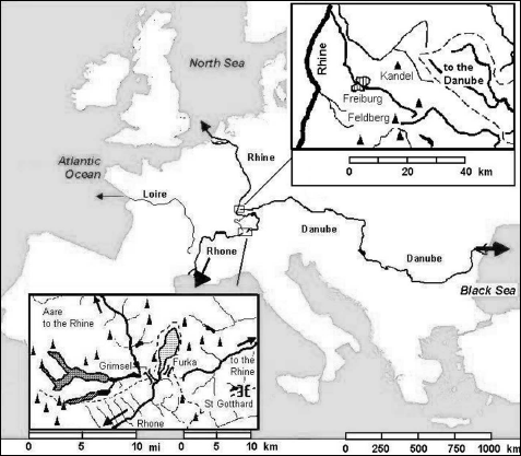
FIGURE 10.3 European rivers. In France the Loire River flowing west to the Atlantic begins only a short distance from the Rhone River. The separate destinies of Alpine snowfall appear in the inset map of the vicinity of Furkapass (Switzerland), where both the Rhine and Rhone Rivers originate. Summits above 3,000 meters are shown. The upper right inset (summits in the range 1,000 to 1,500 m) shows part of the Black Forest (Germany), where very close to the northward-flowing Rhine, the Danube begins its long journey east to the Black Sea by way of Vienna, Budapest, and Belgrade.
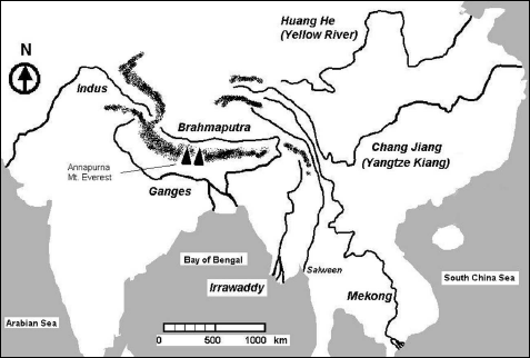
FIGURE 10.4 Asian rivers. Separate destinies of rain and snow on and around the Himalayas, the Pamir and Hindu Kush further west, and the mountains of Szechwan and Yunnan to the east.
From brooks to rivers, the water carries the debris of erosion, and these debris act in turn as erosive agents. The smallest particles (diameter less than 50 microns, say 0.012 inch) are easily moved along with the flow, but they accumulate as silt if the current is weak. When the river overflows its banks, they are left behind as loamy alluvia, collections of the extremely fine particles that result from smashing up all sorts of material—plant debris, gravel, clay, pebbles, and sand—carried along with the water in its descent with the mountain torrents. Where the mountain stream or glacial outflow reaches the plain, the deposits spread out in an alluvial fan. But if the climate dries out, such loamy soil is easily blown away, dust in the wind finally settling down elsewhere as loess. In northern France, Belgium, and Germany, such loess deposits bear witness to the arid conditions that prevailed over parts of Europe not covered by ice during the glacial advances of the last two million years. Loess layers dozens of meters thick cover much of the Yellow River (Huang He) basin of China, with up to 200 meters of loess on the plateau above. These extremely fertile soils are very vulnerable to erosion by water or wind. Flowing water carves out deep ravines and valleys, leaving spectacular pinnacles or natural bridges where less crumbly soil resists erosion. The Yellow River’s color comes precisely from the huge amount of loam that it carries, more than a billion tons every year, 12 percent of the world’s river sediment load (against only 0.1% of the world’s river flow). Fortunately, not all of this good earth is carried off to the sea, part being deposited downstream of the loess plateau, raising high the banks on each side of the river, veritable levees.11 During dry periods, dust blown off the loess plateaus falls on Beijing, and sometimes thousands of miles further east as far as Alaska.
River flow varies through the year, depending on the melting of upstream snow as well as on rainfall. After abundant snowfall during winter and spring, mountain torrents flow furiously, displacing enormous boulders, uprooting trees along their banks, stirring up stones and gravel, carrying off some of this debris to the plain. Still, inasmuch as snowmelt is a gradual process, such floods are not the most dangerous, and as the summer season advances, stream flow dwindles. Much more dangerous floods result when violent storms dump large amounts of water (10 in. of rain amounting to much more than the same thickness of snow) in a matter of hours. People hiking, fishing, cycling, or driving in a narrow mountain valley should certainly not ignore the risk of rapidly rising water. Even in the plain, flash floods can cause enormous damage where a stream emerges at the foot of the mountains. The town of Fort Collins, home of Colorado State University, was badly hurt by the flash floods of the Big Thompson River in 1976 (145 dead) and again in 1997.12 Earlier, on June 10, 1972, the Cheyenne River emerging from the Black Hills wreaked havoc on Rapid City, South Dakota. That calamity was the consequence of an extremely violent long-lived storm, whose heavy rain saturated the soil of the slopes and caused a mudslide into the already swollen stream. Similar floods hit the Languedoc region of southern France from time to time, fortunately mostly with less loss of life. The Sun shines much of the time, and rain is rare; but heavy rain can fall, and when it does it sends floods down the usually dry arroyos, locally called cadereaux. Thus, on October 3, 1988, 420 mm (more than 16 in.) of rain fell in less than seven hours on the hills surrounding Nîmes, and all that water almost immediately flowed through the town center. Of course, it must be admitted that the scale of that disaster, and of others like it, is often magnified by all the paving and other “improvements” which reduce the permeability of the area, and by the fact that many new buildings are put up in harm’s way (as they were in Nîmes, next to the cadereaux where the water had to flow).
In other arid regions, purely natural factors account for the damage caused by floods. During El Niño events (see chapter 7), it can rain in the desert at the foot of the Andes along the Pacific coast from Peru to northern Chile. Although a few rivers fed by snowmelt in the Andes traverse this area, the land is usually bare with hardly any vegetation. When rain falls, it rapidly saturates the soil, and with little loss by evaporation and none by transpiration, it accumulates at the surface and flows in the direction of the Pacific. This runoff transforms the normally dry ravines called quebradas into running streams and swells the trickle of the rivers into a formidable flow. The extremely strong 1997–98 event was only the last of the major El Niño events of the twentieth century, which include 1982–83 and 1972 as well as others that took place before the era of space observation. For example, in March 1925, after three days of more than 200 mm (8 in.) of rain, the Rio Moche (which empties into the Pacific about 300 miles north of Lima, Peru) rose by more than ten feet, washing out roads, bridges, and devastating the town of Trujillo with severe loss of life. Two centuries before, on March 15, 1720, a similar flood destroyed the village of Zaña (also in northern Peru), leaving its high-water mark on the walls of the only building that survived, a convent. During the 1972 El Niño, which no one had predicted, a team of archaeologists from Chicago’s Field Museum, who had come to study the pre-Columbian civilizations of this region, discovered the traces of a still greater catastrophe.13 Agriculture had been practiced in this area since 1000 B.C., and the inhabitants had dug irrigation canals to exploit the water of the Rio Moche and extend their farms to the quebrada rio Seco. To the north, they built the village Cerro la Virgen, and they created a civilization that reached its height in the ninth century, with a capital city (Huaca del Sol) and a distinctive (Chimu) style of pottery. It seems that an exceptional El Niño, toward the year 1100 A.D., caused a catastrophic flood that sent this civilization into decline. The Chimu did build a new capital after the flood, but it was taken by the Incas about 1465; the Spanish conquistadors came on the scene only in 1532. In their diggings between the sites of Huaca del Sol and Huaca de la Luna, the Field Museum archaeologists found ancient bricks that had lost much of their shape as a result of being saturated with water, as well as damaged irrigation canal works. They concluded that the flood stage must have reached as much as 15 meters (50 ft.) above normal river level, with widespread erosion of much of the alluvial plain. The damage wreaked by the El Niño rains of circa 1100 was aggravated by the fact that tectonic movements (quite common between the Andes and the Pacific) had raised the area by several meters above its level of 500 B.C., steepening the slope of the terrain and intensifying effects of erosion. Such shifts also seem to have played an important role in the dramatic changes in the course of the Yellow River (Huang He) in China. Before 1851, only 150 years ago, it emptied into the Yellow Sea (Hoang Hai). But seismic activity led to a change of course, and since then it empties into the Gulf of Chihli (Bo Hai), a few hundred miles to the north.
Each of the world’s great rivers has its own path and its own story. Very little separates the sources of the Rhine, the Rhone, and the Danube, and the three rivers all stay in the same temperate climate zone, but they are far from identical. Some similarities exist between the Danube and Rhone deltas, but hardly with the Rhine in the Netherlands. What about other continents? Both the Nile and the Congo Rivers get much of their water from central Africa, but what a difference in where they go! Starting from Lake Tanganyika and the Lukuga and Lualaba Rivers, the Congo River flows through the tropical rain forest draining a vast watershed of 3,684,000 square kilometers (1,422,000 sq. mi.) where on the average 900 to 3,000 mm (35 to 120 in.) of rain fall each year. Swollen by the contributions of its many tributaries, it carries a couple of trillion tons of water to the Atlantic at an average rate of 50,000 tons per second. The Nile also starts from central Africa, but it flows toward the arid zone in the north. Actually, the very long White Nile starting at Lake Victoria (shared by Uganda, Kenya, and Tanzania) has relatively modest flow. The tumultuous Blue Nile, joining the White Nile at Khartoum (Sudan), brings most of the water, at least during the six months of the year when it is swollen by rains that fall on the hills and mountains of Ethiopia. Over most of its course, more than 3,000 km (1,800 mi.), the Nile receives no water at all; on the contrary, it continuously loses water by evaporation as well as by evapotranspiration of the crops grown since thousands of years by Egyptian fellahs. Studying satellite photos, or looking out the window when flying over Egypt, you can see that vegetated land constitutes but a narrow green band limited east and west by the vast expanse of desert.
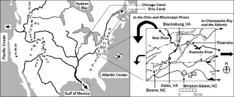
FIGURE 10.5 Water in North America. The Continental Divide (between waters going to the Pacific and the Atlantic) follows the Rocky Mountain chain in the western United States and Canada. Only low hills divide waters going to the Atlantic by way of the Great Lakes and the St. Lawrence River, and waters going by way of the Mississippi and the Gulf of Mexico. Economically important links exist through the Erie Canal, providing a shortcut from the Great Lakes to the Atlantic by way of the Hudson River and New York, and through Chicago to the Illinois River and the Mississippi. As shown in the inset, the Blue Ridge Mountains of Virginia and North Carolina separate waters going directly to the Atlantic by way of the James, Shenandoah, Potomac, and Susquehanna Rivers, among many, from waters going by way of the Ohio and Tennessee Rivers to the Mississippi.
Other striking contrasts appear between the Brahmaputra and the Huang He, although both are born in the mountains and highlands surrounding the Tibetan plateau. Just like the Congo, the Brahmaputra reaches the sea after flowing through well-watered tropical land, in this case Bangladesh.14 As for the Huang He, flowing north it enters the arid interior of China, with less than 300 mm (12 in.) of rain a year. Like the Nile, it creates a green band where it crosses the desert of Inner Mongolia. Only where it turns back south, flowing again to the south of the Great Wall, does the Huang He enter a zone where some rain falls; with additional water from its tributaries, the Yellow River then supports intensive agriculture and very high human population density.
In the Americas, the fate of water from the skies also depends on just where it falls, on one side or the other of the continental divide (fig. 10.5). In the northern Rocky Mountains, water ends up either in the Columbia River’s flow to the Pacific, or in the Mississippi-Missouri system flowing to the Gulf of Mexico. In the state of Colorado, snowmelt feeds on the one hand the rivers flowing to the east and the Missouri, on the other the Colorado River heading southwest through the desert, through the Grand Canyon that it carved out, to the Gulf of California. In the east, Appalachian rainfall flows either toward the Mississippi or eastward on the short direct path to the Atlantic. In South America, the separation between the Orinoco and the Amazon River basins is not very clear, and indeed the two systems are connected in the Amazonas province of Venezuela. In Brazil, on the plateau of Mato Grosso, some of the water flows to the Amazon, some to the Paraná-La Plata system. Still, whether in North or South America, the dominant phenomenon seems to be the continental-scale collection of water coming from many sources fed by rain falling over extended areas. The Amazon River’s flow, 200,000 cubic meters per second, is the largest in the world. It results from collection of water descending from the Andes over a distance of more than 2,000 km (1,200 mi.) from southern Colombia to the Altiplano of Bolivia, and from drainage of an enormous watershed, more than 6 million square kilometers (2.3 million sq. mi., roughly nine times the area of Texas), moreover a very well-watered basin with 1,500 to 3,000 mm (60 to 120 in.) of rain per year. The river’s slope is extremely small over most of its course, and sizable ships make the 4,000-km trip from the Atlantic all the way up the river to Iquitos, Peru, at the foot of the Andes. Continual exchange of water between the atmosphere and the dense vegetation prevails over most of the basin, and so a large fraction of the rain falling in the interior consists of water recycled by evapotranspiration, although the moisture, and even some snow falling on the Andes, “originally” comes from evaporation of Atlantic Ocean water.
In North America, the Mississippi-Missouri system collects water from three principal sources spread out over a watershed of more than 3 million square kilometers (over 1.1 million sq. mi.) and delivers 500 billion cubic meters per year to the Gulf of Mexico (fig. 10.5). The longest branch, the Missouri River, collects a large part of the snowmelt on the eastern slopes of the Rockies from Montana to Colorado, the snowfall a consequence of the uplift of humid air masses mostly coming from the Gulf of Mexico. After crossing relatively dry Montana, the Missouri picks up the Yellowstone and Platte River flows, also coming from the Rockies, and flows on through progressively less dry areas of the Great Plains, finally joining the Mississippi just above St. Louis. The sources of the Mississippi itself lie in northern Minnesota, where the river drains a fairly well-watered area. At Hannibal (made famous by Mark Twain), 120 miles north of its junction with the Missouri, the Mississippi is already impressively wide. Downstream of St. Louis, at Cairo, Illinois, it takes up the abundant flow of the Ohio River, draining a very well-watered area including in particular the western slope of the Appalachians from Pennsylvania to Alabama. Further south, near Memphis, the Mississippi flows by a beautiful campsite, where you can be eaten alive by mosquitoes in the wrong season. On the last stretch to the Gulf of Mexico, the Mississippi picks up still more water from the Arkansas River coming from the Ozark Mountains. In Louisiana it is joined by the Red River, well known to movie-lovers both under its own name and because it flows near Paris, Texas (also the title of a Wim Wenders film perhaps better known to Europeans than to Americans). The Mississippi carries enormous amounts of sediments with it, depositing alluvia all along its meandering course, forming natural dikes or levees as well as the delta before sending the rest into the Gulf of Mexico. The Mississippi, like other great rivers of the temperate zone, flows in its “minor” bed, but from time to time its waters rise and overflow its banks, flooding a much larger area, the “major” bed or floodplain. The deposits of silt and mud make the soil of the floodplain extremely rich, but building there is asking for trouble. Muddy floodwater fertilizes fields, but it blocks roads and soils houses. Every so often, flooding occurs on a spectacular scale, despite (or because of) all the efforts of the Corps of Engineers to control the waters. In 1993 the city of St. Louis was nearly surrounded by floodwaters of the Mississippi and Missouri. Within the floodplain, the Mississippi (and on much smaller scales, the Seine River downstream of Paris, the Jordan south of the Sea of Galilee) follows a meandering course. With alluvial deposits on one bank and erosion on the other, the riverbed tends to shift, finding new meanders and abandoning old ones sometimes together with chains of ponds. Sometimes that leads to embarrassment when the riverbed has run dry just where a bridge was built, with the river gone to flood the road or railway elsewhere. Other rivers make their bed in several more or less straight, more or less shallow channels, within a broader bed of sand, gravel, and sometimes small islets.
Floods are usually counted as natural disasters, but catastrophic damage and loss of life are in part the consequence of careless land use and construction in river floodplains. Floods also fertilize farmland. When the river rises and overflows its banks, the spreading floodwaters slow down or stagnate, leaving time for suspended solids to settle out. These alluvial deposits are so much eroded topsoil from upstream saved for the land. Of course, the Mississippi (“Big Muddy”) hasn’t lost all its load of sediment at its entry in the state of Louisiana. In the last hundred miles, suspended solids help to form and continually reconstitute the Mississippi delta land and bayous of the Cajuns. In China, alluvial deposits due to flooding by the Huang He and the Chang Jiang have played a key role in maintaining fertile farmland, but precisely because this has made high population density possible, it has increased the population at risk from floods. Over the centuries, floods in China have claimed hundreds of thousands, indeed millions of lives, but war and civil strife have often contributed to these catastrophes.
Several great rivers flow in northern forests, crossing tundra and permafrost to empty into the Arctic Ocean: Canada’s Mackenzie River, the Ob, Yenisey, and Lena Rivers of Siberia (figs. 10.4 and 10.5). Other important rivers flow into salty inland seas that lose their water by evaporation: the Volga and the Ural Rivers into the Caspian Sea, the Amu Darya and the Syr Darya into the Aral Sea (fig. 10.2). In fact, the Aral Sea has been shrinking for many years and has now split up into several shallow saltwater lakes, partly because of gross overexploitation of its water for irrigation of cotton fields in the former Soviet republics of Central Asia. It may even dry out completely in coming years. However, the level of the much bigger Caspian Sea has fluctuated from one decade to another, and some geographers note correlation between the level of the two seas. The two bodies of saltwater are separated by the terrible Ust-Urt Desert, but could they be connected by a deep underground water table, and if so, why should there be a see-saw of water level between them?
Another river, not very prepossessing physically, emptying its feeble flow into another inland sea, occupies nonetheless a most important place in the minds of the world’s people (or at least in those of the Jewish-Christian-Muslim tradition): the Jordan River, ending in the Dead Sea. Fed by snow melting on the slopes of Mount Hermon and by other streams coming from springs in Israel, Syria, and Lebanon, the Jordan first flows into the Sea of Galilee (called by some the Lake of Tiberias, but Kinneret in Hebrew according to its lyre shape). A living sea of fish, the Sea of Galilee is a freshwater lake which remains fresh because fresh water flowing in from upper Jordan replaces water flowing out to the southern lower Jordan River or pumped out for Israel’s National Water Carrier, supplying central and southern Israel. But from there on, the Jordan descends into a deep valley, in fact a rift in the Earth’s crust that is the extension of the East African Rift. Less than a hundred kilometers (60 mi.) south of the Sea of Galilee, the river’s waters plunge into a depression that they only half fill. At 396 meters (1,300 ft.) below sea level, the Dead Sea is cut off from the Mediterranean by the Judaean Hills, and from the Gulf of Elath/Aqaba and the Red Sea by an arm of desert that extends from the Sahara by way of the Israeli Negev and the Kingdom of Jordan to Arabia. In this dead end, Jordan waters can exit only by evaporation, leaving accumulated salt behind. Loaded with minerals and strongly salty, these waters support practically no life, apart from some remarkable bacteria—a Dead Sea indeed.
WATER ON THE CONTINENTAL SCALE
As great collectors of water, essential links in the continental part of the water cycle, rivers have always played a major role in the development of civilization. And considering the number of people on this planet today, human well-being depends more than ever on the availability of water. But today’s human activities include not only water withdrawals but also large-scale water pollution. And we still have much to learn about what happens to the water that falls on the land. In many countries, especially rich ones, hydrologists, agronomists, hydrogeologists, and other specialists are hard at work trying to advance understanding of infiltration, runoff, and mechanical and chemical erosion processes under varying conditions. Much progress has been made, in particular in modeling local- and regional-scale processes, thanks to laboratory and field experiments that make it possible to check and improve the models, which can then be applied to practical problems. However, in recent years, it has become clear that scientists need to extend the field of investigation, to look beyond the fascinating but limited problems of small watersheds or catchments that are less than a hundred miles across.
The organization of larger-scale field studies has indeed begun in different parts of the world. In southwestern France (not very large-scale for Americans), the cost of the severe drought in 1989–9015 incited the Météo-France research center to organize, together with other scientists, a pilot “experiment” on atmospheric-hydrologic interactions, so as to better model the soil’s water balance. Although called an experiment, this was really an intensive campaign of field observations, with instruments set up in a dense network covering an area of about 400 square miles to get both meteorological and hydrological data, and with analysis of complementary data from weather satellites, research aircraft, and from more than the usual number of weather balloon ascents. Following this successful campaign, another one was organized in semiarid West Africa. There have of course been many similar campaigns in the United States, in particular around the ARM (not military, but Atmospheric Radiation Measurement), southern Great Plains site of the U.S. Department of Energy, in Oklahoma. Such “ground truth” helps to understand and check what scientists call remote-sensing data, in particular data from weather (NOAA, the National Oceanic and Atmospheric Administration, etc.) and Earth resources (Landsat, SPOT, etc.) satellites.
In recent years, more and more research establishments and scientists have taken part in studies of hydrological processes on the continental scale, nearly always necessarily involving international cooperation. For the enormous Mississippi-Missouri basin, new comprehensive data obtained on the ground, in the rivers, in the air, and from satellites are available to research scientists of many countries, not only the United States. Similarly, Canada runs the Mackenzie basin study, but without reserving the data for Canadian scientists only. For the biggest river basin of the world, Amazonia, Brazil coordinates research on how water, heat, and carbon are exchanged between the air and the surface water, vegetation, and the soil. In Asia, the winter and summer monsoons dominate precipitation in southeast Asia on the one hand, Tibet on the other, with the water flowing through several different river basins, part south, part east, and part north up to the mouth of the Lena River in the Arctic Ocean. Japan coordinates these studies with strong participation by China and Russia. In Europe, more the western peninsula of Eurasia than a true continent, a large-scale study focuses on the Baltic Sea, which can be considered part of a watershed (fig. 10.3). The Baltic, a nearly closed shallow sea, partly covered by ice during the winter, receives fresh water, heavily polluted by urban, industrial, agricultural, and mining wastes, from many rivers from the surrounding countries. Baltic water reaches the North Sea by way of the narrow Øresund strait between Denmark and Sweden, flowing at a rate of 470 billion cubic meters per year, comparable to the Mississippi’s outflow. A dozen countries of eastern and northern Europe take part in the BALTEX program, coordinated at the Geesthacht (Germany) research center near Hamburg.
There is always room for new ideas in research. The orbits of artificial satellites depend on the distribution of mass in the Earth. Today, more than forty years after the start of the space age, scientists have distilled the fine details of the Earth’s gravitational field and exactly how these influence satellite orbits. At least 70 trillion tons of water exist in the form of soil moisture, but little is known about how this is distributed among different watersheds, and how it shifts and changes from one season to the next and from year to year. Even more water lies deeper underground, but evaporation removes 70 trillion tons from land surfaces every year, about the same amount of water as exists as soil moisture. Atmospheric humidity and precipitation depend in part on this supply coming from the poorly known stock in the soil (fig. 6.1, table 6.1). Soil moisture in a particular place can be measured using a neutron sonde, but this varies enormously, even from one cornfield to the next. With the joint NASA—DFVLR (German Air and Space Research Establishment) Gravity Recovery and Climate Experiment (GRACE), scientists from Austin (Texas) and Potsdam (Germany) hope to be able to follow shifting masses of water in the soil and the oceans by way of their minute effects on the satellites’ orbits.16 It’s quite a challenge, but since 1992 the NASA—CNES (French Space Agency) Topex-Poseidon satellite has been measuring sea level over the planet with an accuracy of a centimeter or two (less than an inch), and following ground water is worth trying.
Apart from the thirst for knowledge, are there other good reasons for scientists to devote their professional lives and energy on such research, also spending taxpayers’ dollars, pounds, yen, or euros? As already noted here, and I’ll come back to it later, concern about climate change is in the air. Indeed, humankind is engaged in a global “experiment,” perturbing the planet’s natural “biogeochemical” cycles, in particular by emissions of carbon dioxide. But as an experiment, it’s sloppy: there’s no “control"; in other words, there’s no parallel unperturbed planet whose climate history we can compare with that of our own Earth. If we don’t want to just wait to see how the experiment turns out (with us in the test tube!), if we want to have some idea of the way in which climate is likely to change under the influence of our own actions, our only option (apart from looking into crystal balls or consulting cards or tea leaves) is to use the tool we have: modeling. For nearly five decades now, scientists have developed climate and weather prediction “models.” In such models, they seek to represent the complexity of the real climate system—air, clouds, rain, snow, oceans, ice, fresh water, and land—using a few equations based on well-established laws of nature, and applying them to a limited number of quantities, parameters, describing the state of the system. Since the 1970s, the favored approach has been to put the equations into numerical form and to use powerful electronic computers, introducing measured (or interpolated) values of the parameters at a given instant of time, and solving the equations to determine the future values of those parameters. Thus one “runs” the “general circulation models” or GCMs that are presumed to represent, at least schematically and on a large scale, what goes on in the atmosphere and ocean of the planet. With such models, numerical experimentation is possible: just change the input data according to one or another scenario (for example, increasing emissions of carbon dioxide), and the model computes a possible climate future. How believable are such projections? To have confidence in them, one needs first to show that the models do a good job representing what goes on in today’s climate. Although the models do quite well in many respects, plenty of problems remain. For example, a certain model may give correct precipitation over Arkansas in the summer but not in the winter. But if in a particular model, computed winter rain or snow is too small, it won’t recharge soil moisture adequately and the (computer-world) land will dry out in the summer, crops and plants generally will transpire less (sending less water back to the atmosphere), and summertime model rain should decline. That may not make too much difference for weather forecasts, even several days in advance, because the weather prediction services introduce (the technical word is “assimilate”) new observed data every twelve hours, preventing the model from straying too far from reality. But for long-term climate simulation, the same model will do a poor job, and one may wonder about its reliability in predicting a real-world climate change in response to a given perturbation. Reducing uncertainty requires that bad models be thrown out; and what better method than testing them ever more severely with finer and finer measurements over the entire globe? One fundamental principle guides such analyses: water and energy always flow and change their form on our planet, but they never vanish, nor are they created.