2 Half Dome
SCENERY: 
TRAIL CONDITION: 
CHILDREN: 
DIFFICULTY: 
SOLITUDE: 
DISTANCE: 16.5 miles
HIKING TIME: 8–12 hours
OUTSTANDING FEATURES: Vernal and Nevada falls, stupendous views of Yosemite Valley, steel cables at top (late May–mid-October; do not attempt hike if cables are down)
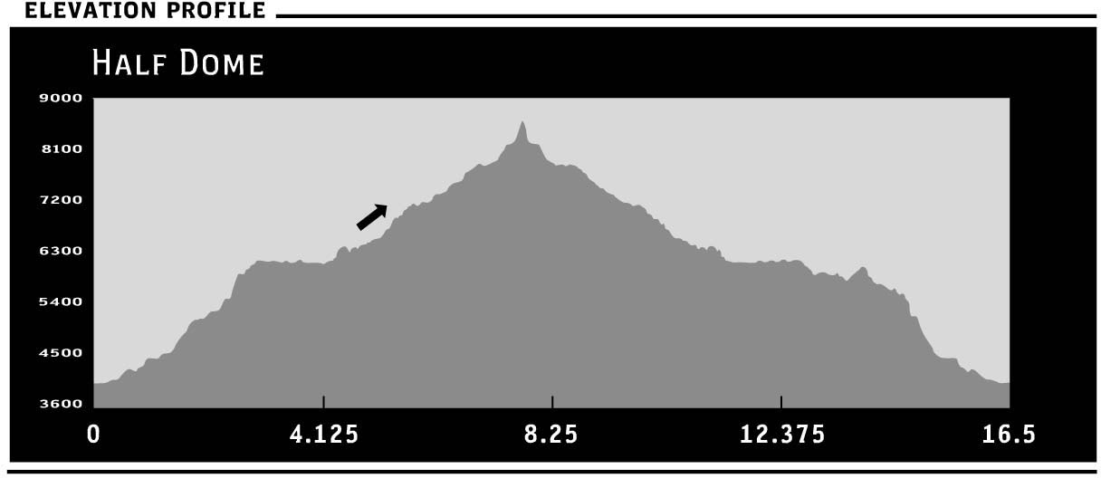
For many, Half Dome defines the Yosemite landscape; this stunning granite monolith appears in more scrapbooks worldwide than virtually any other peak. Reigning supremely over the valley floor at 8,842 feet, its looming form is unmistakable as it beckons hikers to a lofty 360-degree panorama. On the must-do list of nearly every California hiker, this is a challenging and long journey that features rushing rivers, turbulent waterfalls, and steep granite walls. The hike first ascends past Vernal and Nevada Falls to Little Yosemite Valley, plateaus briefly, then continues rising. The last 400 feet of the climb are the most memorable, as they include the infamous Half Dome cables that carry you up the final exposed pitch. But the real prize is the jaw-dropping view once you arrive, which should help you forget nearly all the pain of this 5,000-foot ascent.
DIRECTIONS: Yosemite can be entered via four main gateways: The BIG OAK FLAT ROAD ENTRANCE is on CA 120 West (Big Oak Flat Road) and is the closest western access to Tuolumne Meadows; the ARCH ROCK ENTRANCE on CA 140 (El Portal Road) is east of Merced and the safest bet in inclement weather, as it receives the least amount of snowfall; the SOUTH ENTRANCE is on CA 41 (Wawona Road), north of Fresno; and the weather-dependent TIOGA PASS ENTRANCE is on CA 120 East (Tioga Road) and is the closest eastern access to Tuolumne Meadows. Tioga Road is closed during the winter months due to snow, and sometimes doesn’t open until June or July. While the first three entrances are generally open year-round, all roads are subject to closure; check with the park service by phone at (209) 372-0200 or visit www.nps.gov/yose/planyourvisit/conditions.htm to determine current conditions.
The Happy Isles trailhead is in the southeastern part of Yosemite Valley, 1 mile past Curry Village. Year-round, day hikers are encouraged to leave their cars in one of the day-use parking lots near Curry and Yosemite Villages and take the free shuttle bus to Shuttle Stop #16. There is a parking lot at Happy Isles, but it is often full in the summer months.
| GPS coordinates | HAPPY ISLES | |
| UTM zone (WGS84) | 11S | |
| Easting | 0274558 | |
| Northing | 4179230 | |
| Latitude | N 37°43′57.31″ | |
| Longitude | W 119°33′31.47″ |


 For years, many thought it was impossible to reach the very top of Half Dome on foot. The 45-degree grade, combined with a slick and smooth rock face, made the feat seem unreachable. However, in 1875, George Anderson, a Scottish sailor lured to California with prospects of gold, was the first to prove naysayers wrong. Drilling holes into the granite, installing bolts, and using rope, Anderson attained his lofty goal, thus inspiring others to follow. John Muir was one of the first two dozen adventurers to follow his lead, and today nearly 500 people a day attempt the trek. In 1919, the Sierra Club erected the first set of cables for public use, and now the park maintains them each year. Do not attempt the climb if the cables are down, as it is quite dangerous. It is also important to note the weather before setting out; lightning hits the dome every month of the year and the high, exposed ground leaves you nowhere to protect yourself.
If you are day hiking, be sure to bring plenty of water and a light, and layer your clothing. Temperatures can shift quickly in the mountains and it’s best to be prepared. It’s also best to get an early start before the sun, and the crowds, start hitting the mountain in full force.
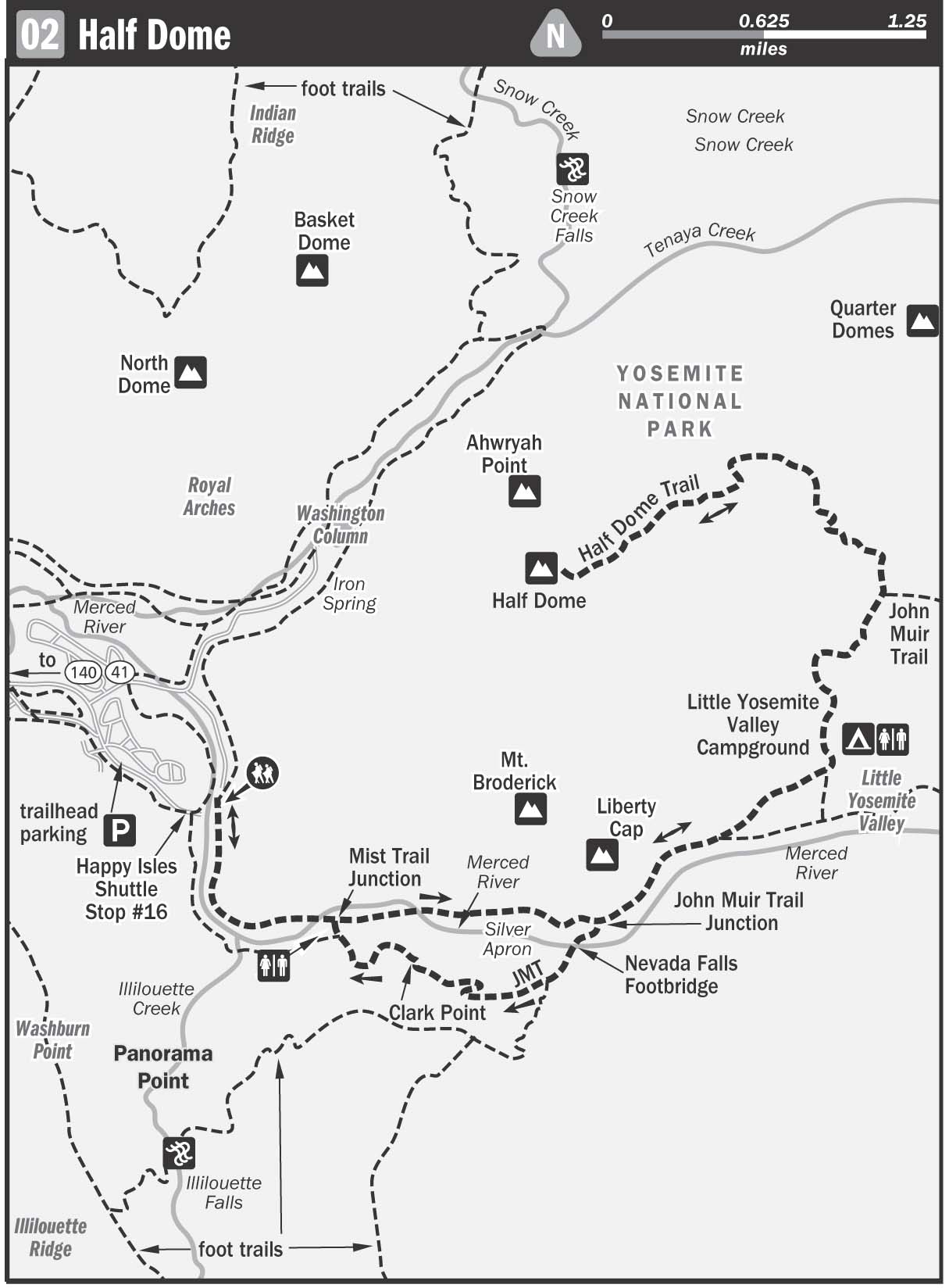
From Happy Isles (4,035 feet), ascend steeply to the footbridge (4,600 feet). Shortly after the footbridge, there is a choice: The Mist Trail continues straight, hugging the river and ascending to Vernal Falls via a steep path that is often wet with waterfall spray, hence the name. This trail is more challenging on the knees with a short stretch bordered by a cable to help the climb. The other option is to veer right (east) and follow the John Muir Trail (JMT) on a more gradual climb through shaded switchbacks. The downside to taking this route is you miss the dramatic waterworks of the fall as seen from below. Our recommendation is to ascend via the Mist Trail and descend via the JMT, as both trails lead to the top of Nevada Falls’ 600-foot drop. For a more detailed description of the hike up to Nevada Falls, see this day hike. Combined, Vernal and Nevada falls make up the Grand Staircase, the name used to describe the tumultuous journey of the Merced River as it thunders its way down to the valley floor.
From Nevada Falls (5,980 feet), follow the JMT and come to a trail junction with solar toilets and many trails. Continue to climb gently on open rock to Little Yosemite Valley (6,140 feet), following the trail north-eastward. Shortly, the path turns dusty, and after about a mile the trail curves downhill to the first legal campground after leaving the valley floor. Stay left at the first junction, and soon reach the established campsites. If you need water, you can access the rushing Merced River just south of camp.
Rangers estimate that 20 percent of all backcountry campers in Yosemite pass through Little Yosemite Valley, so they appreciate your help in lessening the environmental impact by using the composting toilets and packing out all your trash. This overused area is rife with bears as well as aggressive squirrels and stellar blue jays, so keep an eye on your food. During the summer, a ranger is stationed just east of the campground on the other side of Sunshine Creek; a marked spur trail leads to the station off the JMT shortly after leaving the campground.
After leaving Little Yosemite Valley (6,140 feet), ascend moderately for 2.2 miles to the juncture with the Half Dome Trail (7,020 feet). Bypass the sign for the ranger station and continue climbing. The climb is moderately gradual until reaching the last half mile, which is a bit of a rock scramble up the northeast shoulder of the mountain. At times, the path is difficult to discern in the rock, but well-placed cairns keep you from losing your way. Basically as long as you keep going up, up, up, you’re going the right way. Finally, reach the famed Half Dome cables. From late May to mid-October, two steel ropes are suspended at waist height from pipes set in the rock to assist the climb. There are also intermittent wooden cross boards that provide a much-needed ledge to rest upon while attempting the ascent up the 45-degree rock face. Do not attempt the climb when the cables aren’t in place, as the rock is deceptively slick.
Choose a set of gloves from the pile at the base of the cables if you don’t have your own, as serious cable burns are inevitable for the gloveless. For those with a fear of heights, the cable ascent can be a breathtaking experience, and we don’t just mean the view. Take it slowly, as the cables are crowded in the peak season, and you may need to allow others to pass. The one consolation is that finally your arms get the workout instead of your legs. At the top, reach a wide expanse of nearly level rock stretching over five acres. For the brave of heart, belly up to the narrow overhanging northwest point, dubbed the Diving Board (8,836 feet), and stick your head over for an amazing view of the rock wall, maybe even coming face to face with a rock climber. Many rock climbers scale up the sheer face of the dome and “walk off the rock,” meaning that they will hike down the same way you will.
Enjoy epic views in every direction: over the valley, back toward Cloud’s Rest and the Sierra Crest. Tempting though it may be, camping is forbidden on the top of Half Dome. This is to protect the fragile ecosystem that is constantly being threatened by human waste, burned trees, and rocks being moved around for wind shelter. There is, however, a suitable (but dry) campground on the northeast shoulder about half a mile down on the trail from the summit.
Return the way you came. If you opt to descend via the gentler JMT from the top of Nevada Falls, follow the JMT over the footbridge crossing the Merced River and continue descending toward Clark Point. The observation point is named after Galen Clark, a homesteader who moved to Yosemite in 1853 after being diagnosed with consumption (tuberculosis) and was given a short amount of time to live. The magic of the mountains prevailed, Clark’s lungs healed, and he went on to become the first to discover the Mariposa Grove of Giant Sequoia trees. A great advocate of early environmental-protection acts, Clark served as Guardian of Yosemite National Park for more than two decades.
In the early season, there is a nice cooling mist coming off the wall en route to this viewing point. From Clark’s Point, enjoy a great backward panorama of the falls, as well as Liberty Cap and Grizzly Peak. Eventually rejoin the Mist Trail just above the footbridge at Vernal Falls. From here, follow the footbridge and return to the Happy Isles trailhead.
PERMIT INFORMATION: No permits necessary for day hikes