5 Devils Postpile and Rainbow Falls
SCENERY: 
TRAIL CONDITION: 
CHILDREN: 
DIFFICULTY: 
SOLITUDE: 
DISTANCE: 6 miles
HIKING TIME: 3–4 hours
OUTSTANDING FEATURES: Basaltic-rock formations of Devils Postpile, Upper and Lower Rainbow Falls, abundant bird life
The Devils Postpile is one of the most impressive examples of columnar basalt in the world. In layman’s terms, this unique geologic formation is created by volcanic lava flow that cooled, shrunk, and fractured uniformly. The closest rival of any magnitude is the Giants Causeway in Northern Ireland, and after witnessing the mathematical precision of Devils Postpile hexagonal columns you’ll understand why these natural displays are given such otherworldly names. This easy day hike also brings you past upper and lower Rainbow Falls, the former renowned for its 101-foot drop of water and the frequent rainbows that appear in its misty spray. Additionally, you will experience a burn-scarred area rich with bird life and regrowth.
DIRECTIONS: Devils Postpile National Monument can be reached from Mammoth Lakes. From the Mammoth Ranger Station and Visitor Center (on CA 203, 3 miles west of US 395), head west on Main Street for 1.5 miles and turn right to continue on CA 203 (Minaret Road), climbing nearly 5 miles to Mammoth Mountain Inn.
During the summer months, you cannot access Devils Postpile National Monument via car from 7 a.m. to 7:30 p.m. unless you have campground or resort reservations, a handicap placard, or a special permit. Wilderness permits do not allow you vehicular access. Mandatory shuttles operate from the parking area in front of Mammoth Mountain Inn, beginning at 7:15 a.m. Tickets can be purchased at the Gondola Building in the Main Lodge; the 45-minute shuttle to the Devils Postpile area is free for children under age 3, $4 for children ages 3 to 15, and $7 for adults. Shuttle service within the national-monument area between campgrounds and trailheads is free, and the Rainbow Falls Trailhead is Shuttle Stop #9. For more information, contact the Mammoth Ranger Station and Visitor Center at (760) 924-5500 or visit the city’s regional-transit site at www.ci.mammoth-lakes.ca.us/transit/regional_transit.htm.
If you have reservations or are traveling in the off-season (October to early June), continue driving up the hill to the Minaret Summit Entrance Station (9,175 feet) and follow the steep, narrow road the remaining 7 miles to the Devils Postpile Monument Area, Red’s Meadow, trailheads, and campgrounds. The Rainbow Falls Trailhead is the last turnoff on your right as you head south toward Red’s Meadow Resort.
| GPS coordinates | Rainbow Falls | |
| UTM (WGS84) zone | 11S | |
| Easting | 0316528 | |
| Northing | 4164310 | |
| Latitude | N 37°36′29.20″ | |
| Longitude | W 119°04′42.56″ |


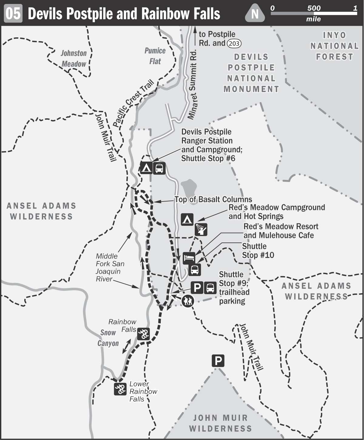
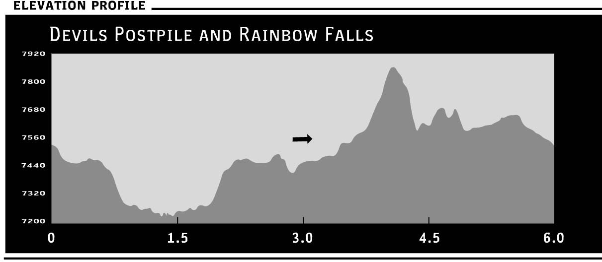
 The trail begins at the Rainbow Falls Trailhead, Shuttle Stop #9 (7,600 feet). Begin by descending dusty pumice through the Rainbow Fire area, cross a footbridge, and continue walking downhill. The easy accessibility, short distance, and gentle terrain make this a popular hike for kids and day-trippers. While the immediate landscape is scorched, the views of the mountains are expansive and broad. Of the trees that do remain, many are lodgepole pines, so named by Lewis and Clark when they saw them being used by Native Americans in their teepee construction.
In August 1992, fire swept through this region, destroying more than 8,000 acres. Dubbed the Rainbow Fire, due to its proximity to the waterfalls, the blaze resulted from a lightning strike and the ensuing winds that stirred the embers days later. Once roaring, it took nearly two months before the last hot spots were extinguished. The ground cover served as fuel while the winds spread the damage, and scores of hikers were evacuated. However, it’s not all dire news. Forest fires are natural occurrences, and the tree snags that remain standing serve as an important and desirable habitat for bird species. Additionally, the opened forest canopy means that more sunlight reaches the ground, allowing for greater diversity of plant life.
Follow the trail as it parallels a fork of the San Joaquin River, vibrant lupine lining the banks, and continue descending to Rainbow Falls (7,400 feet), a dramatic sheet of water cascading down 101 feet. There is an overlook from which to admire this incredible example of water’s force, and the brilliant display of rainbows in the mist aptly gives meaning to the falls’ name.
It’s possible to walk down to the waterfall’s base, where many enjoy wading and fishing in the cool jetty of water. Or continue along the trail to another stone observation platform. The waterfall’s dramatic event is owed to two different types of volcanic rocks. The top layer of stone is a more robust, erosion-resistant rock, while the bottom layer is softer and more susceptible to the continuing cascade of water. This undercutting process gradually creates an alcove beneath the stronger rock layer that eventually caves in, hence the debris at the bottom of the falls.
To access the lower falls, turn left at your first opportunity to continue heading southwest along the trail. Most visitors ignore this trail, but, while less dramatic, Lower Rainbow Falls (7,200 feet) offers a bit more solitude and is the perfect spot for dipping your feet in the rushing river while picnicking. There is also a small swimming hole just below the fall for those willing to brave a dip. It’s a serene landscape as granite boulders tumble into the river, and cottonwoods, willows, and alders sway in the breeze. Descending through a pine forest, there are many tree snags attracting roosting birds, while closer to the river, cow parsnip and redbud are scattered within the grasses.
Return the way you came, climbing gently through conifers on a pumice path. Numerous side trails lead to Red’s Meadow, and the return walk provides clear views of Mammoth Mountain’s bald backside.
Follow signs to Devils Postpile and continue to climb gently along the dusty trail. Interestingly, the 800 acres of Devils Postpile National Monument were originally considered a part of Yosemite National Park in 1890. However, aggressive efforts made by mining interests reversed this decision, and in 1905, Congress removed the site from the National Park. Five years later, the Forest Service was approached by those who wanted to create a rock dam on the San Joaquin River to power the electricity of their mining operations—a move that would require the dynamiting of Devils Postpile. Luckily, the Sierra Club, along with University of California professor Joseph LeConte, responded with their own lobbying efforts to President Taft, and the area was saved. Christened a National Monument in 1911, the area once again enjoys federal protection.
At the juncture with the base of Devils Postpile (7,560 feet), turn right to follow a sign to the top of the columns and begin a short series of switchbacks to see the basaltic rock formations from above. Like a granite garden of paving stones, it’s hard to believe that the uniformly hexagonal stones were not cut by hand. The columns were exposed when a glacier traveled down the Middle Fork of the San Joaquin River some 10,000 to 20,000 years ago, carving away a side of the postpile and exposing the sheer wall of columns that we see today. The parallel grooves on the top of the stones are scrapes from rocks trapped in the slow-moving glacier. Looking across the river, there are views of lush Johnston Meadow.
Loop around, descending, and come to another junction. The north trail to the right leads to the Devils Postpile Ranger Station, Campground, and Shuttle Stop #6. A free shuttle from here leads back to the trailhead (Shuttle Stop #9) for any weary walkers. Otherwise, turn left and return toward the rock formations, passing in front of the basalt columns. The trail begins a short, moderate ascent before reaching a juncture with a trail toward Red’s Meadow or Rainbow Falls. Follow the signs back to Red’s Meadow Resort to return to the starting trailhead.
PERMIT INFORMATION: No permits necessary for day hikes