Reconstructed Everett Road covered bridge in Cuyahoga Valley National Park

The six parks of the Midwest offer a variety of experiences, some suburban and close-at-hand, others rugged and otherworldly. At these parks, water, in all its abundant power, nourished, built, eroded, and sculpted the diverse landscape of America’s heartland.
Streams flowing from the young Rocky Mountains laid down the colorful mud that rivers would later carve into the buttes, gorges, and pillars of the Dakota badlands. The seashell-hued bluffs of South Dakota’s Badlands National Park reveal layers of sedimentary history, the work of seas, rivers, and volcanoes. These wilds so inspired a visionary from New York that he decided to dedicate himself to conservation. His legacy endures in Theodore Roosevelt National Park in North Dakota.
At Wind Cave, bison roam and graze a 28,000-acre swath of pine forest and prairieland, with the remains of a “buffalo jump.” This South Dakota cliff formation literally stopped animals in their tracks. It is a reminder of the mighty quadruped’s significance to American Indian hunters. Beneath the Earth’s surface lies a labyrinth of passageways that extends for miles, making Wind Cave one of the longest known underground cave formations in the world. Geological wonders abound.
Scores of lakes and streams lace the forests of Minnesota’s Voyageurs National Park, named for the late 18th-century French Canadian fur traders who for 100 years paddled these waters. To the east, Michigan’s Isle Royale encompasses an entire island ecosystem. In and around its lakes, thick forest, and fjordlike coast a delicate ecosystem plays out. Among the star players: wolves and their prey, moose. Ohio’s Cuyahoga Valley National Park provides easy access to the natural world right in Cleveland’s backyard. A revitalized bald eagle population coexists with human activities like hiking and biking along a 19th-century canal, farmers markets in spring, and wintertime cross-country skiing.


Badlands landforms
South Dakota
Established November 10, 1978
244,300 acres
There comes a moment when vast rolling grassland drops away to a fantastic landscape of pyramids, pillars, bluffs, knife-edge ridges, and narrow canyons. The star in these formations: water. It’s been carving away at the cliffs for the past half million years or so. Badlands National Park is a place of great theatricality, an enormous stage set—colorful, dramatic, and not quite real. Architect Frank Lloyd Wright referred to it as “an endless supernatural world.”
For those traveling it on foot, horseback, or in a covered wagon, this rugged terrain was certainly a bad land; for modern visitors, it’s nothing short of wondrous.
Today’s scenery began forming when streams (especially the White River to the south) started cutting down into a plain composed of many rock layers built up over tens of millions of years. These strata include the sediments of an ancient seafloor, silt and gravel deposited by rivers, and thick layers of volcanic ash. Exposed now, like a sliced layer cake, they create a colorful vision of buff, yellow, pink, and brown. After a rain, the land displays a seemingly infinite spectrum of subtle tones.
The park’s formations comprise a section of a geologic feature called the Wall. This 100-mile-long natural barrier ridges the landscape, dividing western South Dakota’s upper and lower grassland regions. The soft rock erodes easily, at the rate of about an inch a year, which means that in another 500,000 years all this craggy country could be a flat plain.
More than half the park is grassland, where bison and pronghorn graze; bighorn sheep clamber about the steep slopes. More than 200 species of birds have been recorded in the park, and when rainfall has been sufficient, the prairie wildflower display is as colorful as it is varied. A drive-through park? Badlands can, and should, be so much more.
► HOW TO VISIT
Indeed, it’s all too easy to exit Interstate 90, drive the 39-mile loop road while stopping for photos, and be back on the freeway in a couple of hours. It’s much more rewarding to spend an entire day or two exploring the park: walking among the bizarre formations, driving the Sage Creek Rim Road, taking in a ranger-led program, and learning about the trove of fossils found here, from ancient alligators to the ancestors of today’s dog.
Eastbound travelers on I-90 in a hurry can enter the park at the Pinnacles (west) Entrance, drive the scenic road, and rejoin I-90 north of the Northeast Entrance, where westbound drivers enter. You’ll be better prepared to enjoy the park, though, if you use the latter entrance. You can stop at the Ben Reifel Visitor Center to get advice from a ranger and to view exhibits on geology, fossils, and natural history.
While driving the Badlands Loop Road you should, at a minimum, walk the 0.75-mile Door Trail or the 0.25-mile Fossil Exhibit Trail. Where the loop road turns north to exit the park, continue on unpaved Sage Creek Rim Road for the best chance to see bison, pronghorn, and other wildlife.

The Loop Road & Beyond
A short way from the northeast entrance is the Big Badlands Overlook, a parking area with an expansive view of the rugged terrain for which the national park is known. Just a couple of miles farther, trails offer chances to see picturesque rock formations up close. The very short Window Trail is wheelchair accessible, as is the first section of the 0.75-mile Door Trail, where the focus is on geology. The 1.5-mile, somewhat strenuous Notch Trail climbs to a viewpoint with a splendid panorama of the White River lowlands and the Pine Ridge Reservation. Just beyond Cedar Pass is the 0.5-mile loop Cliff Shelf Nature Trail. Here, a “slump” of rock eroded from the Wall forms a flat spot where junipers and cottonwoods grow, creating a mini-haven for birds and other wildlife. The trail rises to a platform with more fine views.
The road quickly reaches the hub of park activity: the Ben Reifel Visitor Center and the concessioner-operated Cedar Pass Lodge, which offers lodging, camping, dining, and a small store.
Tour the exhibits at the visitor center, which interpret park geology, natural history, and the important fossil discoveries made in the park. Due to the rapid rate of erosion, new fossil finds occur frequently.
The area that is now Badlands National Park lay under an ocean during the age of dinosaurs, and so the park lacks fossils of these reptiles. What it does have is one of the world’s richest collections of fossil mammals from the Oligocene epoch, about 30 million years ago, along with creatures such as turtles and alligators. About 3 miles down the road is the 0.25-mile Fossil Exhibit Trail, a good place to learn more about fossils.
The wheelchair-accessible trail passes molds of several of the finds made in the park, including that of an oreodont, a piglike animal whose fossils are the most common found here. The era of discovery continues at Badlands: In 2010, a seven-year-old girl found a significant fossil from a saber-toothed cat near the visitor center.
The loop road winds among seemingly endless rock formations, many of them displaying the varicolored layers deposited by seas, rivers, and volcanoes over tens of millions of years. The route alternately climbs up the Wall and descends again, offering fine panoramas along the way. The lovely colors of rock strata are seen at their best near Dillon Pass, at sites such as Conata Basin Overlook and Yellow Mounds Overlook. Dillon Pass is the only place along the road where all the park’s rock layers can be seen at once.
Approaching Pinnacles Overlook, watch for bighorn sheep on nearby slopes. As the main loop road turns north to exit the park at the Pinnacles Entrance, continue west instead on Sage Creek Rim Road (unpaved but usually in good condition).
Badlands includes the largest expanse of mixed-grass prairie in the national park system, and in grassland areas you’re likely to see black-tailed prairie dogs and larger mammals, including bison and pronghorn. Here, too, are even more vistas of intricately eroded buttes, spires, and canyons to the south.
Sage Creek Rim Road drops down off the Wall into an environment of wooded canyons and lush grass, continuing to the Sage Creek Campground. Campers in this peaceful and scenic spot sometimes awaken to the sight of bison grazing nearby.
Hiking and backcountry camping are allowed (and encouraged) in the park’s 64,144-acre Wilderness area. This is where to combine beautiful vistas and solitude, but talk to a ranger and be well equipped before starting out. There are no trails in the backcountry except those made by bison, and no signs either—bison using them for scratching posts knock them down.
Information 
|
How to Get There From Rapid City, SD (about 60 miles northwest), take I-90 east to Wall, or continue 20 more miles to S. Dak. 240. When to Go Summer sees the park’s highest visitation—and often very hot weather. Spring and fall offer more moderate temperatures. Winter can be beautiful in the park, but watch the forecast for occasional snowstorms. Visitor Center Ben Reifel Visitor Center, on S. Dak. 240, 8 miles south of I-90, is open year-round. Headquarters P.O. Box 6 |
Camping Cedar Pass Campground (100 sites) is open year-round; for information on this privately managed site, contact Cedar Pass Lodge (see below). The less developed Sage Creek Campground, also open year-round, offers open camping. There is no water available. Both campgrounds are first come, first served. No permit is required for backcountry camping, although campers are encouraged to contact a ranger before a trip. Lodging Lodging is available in the park at concessioner-operated Cedar Pass Lodge (cedarpasslodge.com; 877-386-4383) and in the nearby town of Wall (wall-badlands.com), adjacent to the park. |

Brandywine Falls
Ohio
Established October 11, 2000
33,000 acres
Between Cleveland and Akron sits Cuyahoga Valley National Park. A park between two cities? Yes, one with a vast array of pleasures. In what other park can you ride a scenic railroad, stop at a roadside farm to buy fresh-picked blueberries, watch a glassblower create a decorative bowl, jog alongside a 19th-century canal, and hear a concert by one of the nation’s finest symphony orchestras?
These hardly seem like typical national park activities, but they come with the territory.
Located in a suburban corridor in northeastern Ohio, Cuyahoga Valley was established as a national recreation area in 1974; it was designated a national park in 2000. Unlike traditional wilderness parks in the West, it was pieced together amid a modern landscape of towns, highways, farms, and city parks.
Over time, Cuyahoga Valley National Park has incorporated or partnered with all sorts of attractions, from historic inns to ski resorts to the Cleveland Orchestra and its summer concerts at Blossom Music Center.
In the years since it was established, attitudes regarding the park’s farms have changed. Many farmsteads were abandoned when the park opened, having sat derelict for years. Now the National Park Service, together with the local Countryside Conservancy, is offering incentives for sustainable agriculture, aiming to preserve the traditional lifestyle of the area. Today, around a dozen farms operate within the park, and a summer farmers market at Howe Meadow has become very popular.
Make no mistake, though. Cuya-hoga Valley offers a wide range of rewards for lovers of the natural world. Visitors can explore geological features and enjoy some of the prettiest waterfalls in the eastern United States.
Rugged gorges are dotted with wildflowers in spring, and trails through dense forest offer a soothing escape. Beavers and otters swim in park marshes, while bald eagles and peregrine falcons nest nearby. Anglers cast for steelhead trout in the revitalized Cuyahoga River.
Linking many park sites is the Ohio & Erie Canal Towpath Trail. The Towpath Trail is truly the heart of the park, patronized by walkers, runners, bicyclists, and in winter by cross-country skiers. It traverses the park for 20 miles in its 84-mile route, which starts in Cleveland and runs south through four counties.
► HOW TO VISIT
You can experience the park in a single day, but to take advantage of the park’s cultural offerings, plan on two or three days. The centrally located Boston Store Visitor Center, a restored 1836 building located on the Towpath Trail, provides information on park activities. Walking part of the Towpath Trail is a must, as are trips to waterfalls, such as Brandywine Falls. Check at the visitor center for activity options, including information on a trip on the Cuyahoga Valley Scenic Railroad (fee; vsr.com) and where to rent bikes. To get the most from a visit to the park, combine nature excursions to spots such as the Ledges with activities such as farm visits or a stroll around the village of Peninsula, with its shops and art galleries.
Ohio & Erie Canal Towpath Trail
Covering 20 miles, north to south, this wheelchair-accessible hike-bike path combines history, nature, and recreation. It is the park’s most popular attraction.
In the 1820s, a canal was excavated that roughly paralleled the Cuyahoga River, opening a route to transport goods between Lake Erie and the Ohio River. Although it operated for only a few decades, until railroads made it obsolete, the canal transformed commerce in the young United States and turned Ohio into an economic powerhouse. Today, the Towpath Trail follows the route used by mules to pull barges along the canal.
The Canal Exploration Center, in the northern part of the park, is housed in a historic building that, over more than a century and a half, has been a tavern, a store, a boardinghouse, and a blacksmith shop. Today, the center uses innovative displays and an operational lock to bring the canal era to life. This is one of several spots in the park where you can board the Cuyahoga Valley Scenic Railroad, which operates along a 26.5-mile route between Rockside Station in the north and Akron, south of the park. Twenty miles of track are within the national park.
Not only is the train an engaging way to see the park, it provides hikers and bicyclists the opportunity to speedily make their way along the Towpath Trail. They flag the trains down at designated stops and ride back to their starting points. The train also offers a variety of seasonal and themed evening trips.
To the south, the Towpath Trail reaches the Boston Store Visitor Center and the nearby small town of Peninsula, with bike rentals, restaurants, galleries, and shops, including a store operated by the nonprofit support group called the Conservancy for Cuyahoga Valley National Park (conservancyforcvnp.org). The village makes a great spot for a break during a walking or biking trip.
The most popular site in the park for bird-watchers, nature photographers, and anyone else interested in outdoor life is the Beaver Marsh, located near the railroad’s Indigo Lake station and the Towpath Trail’s Ira Trailhead. This large wetland was once an automobile junkyard. After the vehicles were removed, beavers dammed the canal and created a marsh that’s now home to muskrats, otters, waterfowl, songbirds, turtles, and a wealth of other wildlife species. The Towpath Trail crosses Beaver Marsh on a boardwalk, which is especially popular for wildlife-watching at dawn and dusk.
Waterfalls
The park’s most famous waterfall, and justly so, is Brandywine Falls, a 65-foot cascade that makes its way down a series of sandstone ledges. Platforms provide various viewing levels, and the gorge below the falls is among the best places in the park to see spring wildflowers. A short drive west of the Boston Store Visitor Center is the trailhead for the short walk to Blue Hen Falls, a very pretty spot—especially in the fall when the maples and beeches turn color.
In the northern part of the national park (owned by Cleveland Metroparks) are Tinkers Creek Gorge and nearby Bridal Veil Falls. Dense hemlocks grow in this steep-sided valley among the hardwood trees, one of the reasons the gorge is a national natural landmark. Several smaller waterfalls can be seen along tributaries of Tinkers Creek. The scenic overlook on Gorge Parkway offers fine views.
Elsewhere in the Park
Donated to the public by a wealthy businessman, Virginia Kendall Park is a center for hiking and winter recreation, including sledding, cross-country skiing, and snowshoeing. Several historic Civilian Conservation Corps structures are located here.
The best-known Kendall Park attraction is the Ledges, where a 1.8-mile trail loops around striking sandstone formations that have eroded not only into ledges but also into horizontal cracks and deep vertical fissures large enough to walk through. (Be sure to read the interpretive signs about the underlying geology before walking the trail or you’ll miss a large part of its appeal.)
Water evaporating from the sandstone creates a cooling effect, which in turn creates a microclimate where hemlocks, birches, and ferns flourish, as do such nesting birds as winter wren, Canada warbler, and hermit thrush, species that are rare else-where in Ohio.
The Ledges Overlook takes in a wonderful vista over the thickly wooded Cuyahoga Valley to ridges far to the west. This popular spot is famed for its sunset views.
Not far from Beaver Marsh, Hale Farm & Village, operated by the Western Reserve Historical Society (wrhs.org; 330-666-3711), re-creates 19th-century Ohio rural life through historic buildings, costumed interpreters, crafts demonstrations (such as blacksmithing and glassblowing), seasonal house and garden tours, and working farm animals.
The nearby Everett Road Covered Bridge is a reconstruction of an 1870s structure that was destroyed in a 1975 flood. Its appealingly nostalgic design is typical of the more than 2,000 covered bridges that were built in Ohio in the 19th century.
Information 
|
How to Get There From Cleveland, take I-77 south and from Akron take I-77 north to I-271 and go north 3.7 miles to Ohio 303. Go east 1.8 miles to Riverview Rd. Head north 1.6 miles and turn east to reach the park visitor center. When to Go Late spring through fall is best for enjoying the Towpath Trail and hiking trails; colorful foliage is a bonus in autumn. Cross-country skiing and sledding are popular in winter. The Cuyahoga Valley Scenic Railroad operates year-round except for two weeks in Jan. Visitor Center The historic Boston Store is the park’s main visitor center, located on Boston Mills Road, just east of Riverview Road. Open year-round. |
Headquarters 15610 Vaughn Rd. Camping Five primitive campsites (open Memorial Day weekend through late Oct.) are located near the historic Stanford House. For information, 330-657-2909. Lodging Two lodging options are located in the park. The 1848 Inn at Brandywine Falls (innatbrandywinefalls.com; 330-467-1812) offers B&B-style rooms. The Stanford House (330-657-2909) offers dorm-style rooms. Hotels are plentiful in nearby towns, including Hudson and Independence. Contact the Akron/Summit Convention & Visitors Bureau (visitakron.summit.org). |

Michigan
Established April 3, 1940
571,790 acres
A fog-shrouded archipelago of glacier-scoured rock and dark coniferous forest, Isle Royale National Park comprises a main island known for its immigrant wolves and moose, and a flotilla of some 400 smaller isles set amid the clear icy waters of vast Lake Superior. Limited by a short visitor season and water-only access, this is one of the least visited parks. Yet those who see it once tend to return.
Isle Royale National Park was designed to remain a wilderness. And so it has—a wild place with no roads, few services, many foot trails, and a network of water routes for canoes and sea kayaks.
Isle Royale, 45 miles long and 9 miles wide, sports one hotel for overnighters. Rock Harbor Lodge is a homey, comfortable place at Rock Harbor. Beyond that are dozens of rustic campgrounds scattered on the shores of bays and lakes, and along the promontories.
Islands are defined by the water around them. Isle Royale includes a lot of water; its boundary stretches 4.5 miles from any exposed land. Shipwrecks ring the island as grim monuments to powerful currents and shifting fog. The forest, drenched by rain and frequent mist, stands in spongy carpets of moss and lichen.
Tea-colored creeks pour off the ridges, filling wetlands. Animals include, most famously, wolves, plus moose, foxes, river otters, snowshoe hares, beavers, bald eagles, and loons.
► HOW TO VISIT
Few visitors make it a day trip. The average stay is four days, no surprise considering the effort and preparation it takes to get here. Although private boats are allowed, most visitors arrive on ferries from Michigan, via Houghton or Copper Harbor, or from Minnesota, via Grand Portage. Activity centers on Rock Harbor, one of two ferry entry points—Windigo is the other. Both have visitor centers. From Rock Harbor, trails and water routes stretch the length of the island. The Greenstone Ridge Trail traverses the island’s rocky spine; numerous connecting trails offer a web of hiking options. Unusual for wilderness parks, some campsites feature shelters that provide relief from rain and insects.

Rock Harbor
The visitor center, on the ferry dock, is the place to go to get oriented and to pick up permits for wilderness trips. If you’re not headed off on a multiday backpack or canoe trip, start with the Scoville Point loop trail (4.2 miles), a mostly level path that burrows through the forest, crosses wetlands via plank bridges, and offers oceanlike views of Lake Superior before emerging on the smooth, exposed rocky shelf of the point. Interpretive signs along the Stoll Memorial section of the trail (1.8 miles) touch on nature and history themes. Among the sights: abandoned mine shafts from the late 1840s, a chapter in the island’s long history of copper extraction that begins with native peoples thousands of years ago. (Ancient diggings and pits have been identified in many parts of the island.) The loop trail follows the inner side of the peninsula, facing Tobin Harbor. The haunting cry of loons might accompany you.
In the other direction from Rock Harbor, a 3.8-mile loop follows the shore past pebbled coves and basalt headlands to Suzys Cave, an erosion feature caused by waves when the lake level was higher than it is now. Muddy patches of the trail can be slippery, but they are also the best places to find tracks of passing wildlife. Moose tracks are unmistakable: They look like the prints of very large deer. As for canine tracks, the small ones are fox; the large ones belong to wolves.
Other short trips near Rock Harbor require a boat, which can be rented in the park. On Raspberry Island, just a half-mile across from Rock Harbor Channel, an interpretive trail details the composition of a bog: It is a lake grown over by a floating mat of moss, orchids, sundew, pitcher plants, Labrador tea, and many other plants. Raspberry’s neighboring islands also are worth exploring—but only if the water is calm.
Sheltered Tobin Harbor is ideal for slow exploration by canoe or kayak. Narrow channels and little islands stretching 7 miles to Blake Point provide endless variety. Listen for loons; this is good habitat for these denizens of the North Woods.
Stretch your legs on the 1-mile climb to Lookout Louise. The trail begins at a boat dock partway up Tobin Harbor. Watch for moose while skirting Hidden Lake, and for carnivorous pitcher plants in marshy areas along the planked walkway. The trail climbs past Monument Rock, a sea stack carved by the stormy lake when water levels were higher.
After winding through birch and conifers over mossy rock slabs, the path ends at a high breezy ledge, a fine place for a picnic lunch. At your feet sprawls an intricately formed landscape of narrow bays, rocky islets, dark forest, and the gleaming expanse of Lake Superior. Ambitious hikers can walk 9.4 miles back to Rock Harbor via the Greenstone Ridge and Mount Franklin.
The Rock Harbor Lodge, together with the park service, combines guided boat trips with interpretive walks to several locations including historic Edisen Fishery and Rock Harbor Lighthouse; and to Passage Island, several miles off the island’s eastern tip, with its hidden harbor and lighthouse.
Arrangements for guided boat trips, interpretive walks (fee), and kayak, canoe, and motorboat rental are made at the Rock Harbor Lodge office (rockharborlodge.com).
A wilderness promontory, then a copper mine, a private hunting club, and back to wilderness as part of the national park, this area provides a few services at the far end of the island, including a visitor center, campground, camp store, and rustic cabins. Windigo is reached via ferry from Rock Harbor Portage.
Pick up a trail guide at the visitor center, and follow the 1.2-mile Windigo Nature Trail through a mixed forest of cedar, birch, and maple. Hike 2 miles to Grace Creek Overlook on Feldtmann Ridge, or 3 miles in the other direction to a lookout on Minong Ridge.
Paddle (in a rental boat, kayak, or canoe) the protected shoreline of Washington Harbor and, if conditions permit, explore the small islands just beyond. Float over the wreck of the passenger ship America, sunk in 1928. It was one of 25 ships claimed by the rocky shoals, fog banks, and storm winds of Isle Royale; its bow is visible just under the surface. This is one of ten wrecks open to scuba divers.
Backcountry
Backcountry travel is done by boat or on foot, or a combination. Crossing the island the short way, trails go up and down and up again. It appears as if the island was stroked lengthwise by a giant comb. Ridges protrude like old bones, thinly forested and often with good views of open water. Between ridges, you’ll find lakes, bogs, beaver ponds, and dense forest.
To hike the entire Greenstone Ridge Trail is the ambition for some, but other routes can provide more variety. To camp in secluded places like Moskey Basin or Lane Cove, combined with some time high on the Greenstone, makes for a delightful trip. If you’re willing to portage, you can camp and paddle on inland lakes; or loop through the intricate channels at the east end of the island, and return by crossing over inland lakes.
In planning, keep in mind that island trails are not always smoothly constructed. In many areas, they resemble game trails, following the natural terrain. They can be rocky or muddy, and walking can be slow.
It’s wise to be conservative when planning distances. As for boating, Lake Superior’s moods are infamously changeable and potentially dangerous. Be prudent; plan for the unexpected; allow extra time.
Information 
|
How to Get There From Houghton, MI, the Park Service (nps.gov/isro) runs the Ranger III to Rock Harbor, a 6-hour trip. The Royale Line (isleroyale.com) runs from Copper Harbor, MI, to Rock Harbor in 3.5 hours. From Grand Portage, MN, the Grand Portage-Isle Royale Transportation Line (isleroyaleboats.com) reaches Windigo and Rock Harbor in 2.5 hours, with pickup and drop-off service along the way. Isle Royale Seaplanes (royaleairservice.com) flies seaplanes from Houghton to Rock Harbor, a 40-minute trip. Camping Non-fee permits are required for all camping and overnight boat docking or anchoring. Thirty-six backcountry campgrounds include 17 with group sites; many have screened shelters in addition to tent sites. Parties of 1 to 6 get permits on arrival (no reserved sites); groups of 7 to a maximum of 10 can reserve sites and must obtain permits in advance through park headquarters. |
When to Go The park is open mid-April through Oct. Weather can be unsettled in spring and fall; stormy conditions on Lake Superior can affect transport. July and Aug. are the most popular months. Visitor Centers Visitor centers at Windigo and Rock Harbor are open daily in season, with reduced hours outside of July and Aug. A visitor center at park headquarters in Houghton is open year-round. Headquarters 800 East Lakeshore Dr. Lodging The Rock Harbor Lodge (rockharborlodge.com; 906-337-4993) offers rooms with private baths, plus a dining room and a dockside store. Also available are rustic one-room cabins in Windigo. |

Park badlands
North Dakota
Established April, 25, 1947
70,467 acres
Only one of our national parks is named for a person, and Theodore Roosevelt National Park is a most fitting honor. President Theodore Roosevelt is arguably the most influential conservationist in American history. It was his experience in North Dakota—a place with “a desolate, grim beauty of its own, that has a curious fascination for me”—that set him on the path that would see him establish five national parks, 18 national monuments, and scores of wildlife reserves and national forests.
Roosevelt came to the region in 1883 to hunt, and later entered the cattle business. Though he fell in love with the area and the “strenuous life” of the frontier, he soon became dismayed by the decline of wildlife and degradation of the environment.
“It is not what we have that will make us a great nation; it is the way in which we use it,” he later wrote.
What is this landscape that so inspired Roosevelt? It began to take shape about 60 million years ago, when material eroded from the Rocky Mountains formed the Great Plains. Ash from western volcanoes contributed additional layers, as did vegetation that was buried and transformed into lignite coal.
Streams, including today’s Little Missouri River, cut into the varied rock strata, creating an astonishing variety of canyons, bluffs, buttes, and rounded mounds in colors from pink to brown, yellowish-buff to gray. Roosevelt described the land as “so fantastically broken in form and so bizarre in color as to seem hardly properly to belong to this earth.” Around these badlands stretch wide grasslands, in places giving a sense of the vast prairie where American Indians lived and hunted.
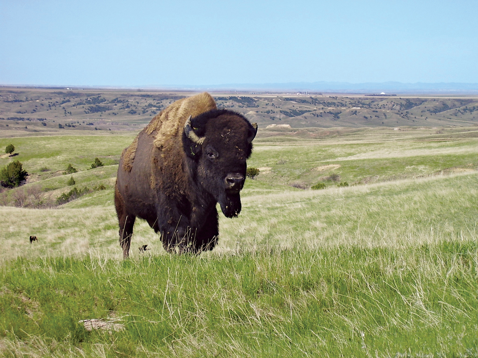
Bison are the most conspicuous and popular of the park’s animals, but there are also pronghorn, elk, bighorn sheep, mule and white-tailed deer, coyotes, badgers, porcupines, and black-tailed prairie dogs.
The park comprises two main units about 70 road miles apart, plus one smaller unit. Each main unit features a scenic drive. Hiking trails, both short and long, allow a fuller exploration of this diverse and beautiful landscape.
► HOW TO VISIT
If you have very limited time, tour the South Unit, stopping at the visitor center to learn about Roosevelt’s legacy. Follow the 36-mile scenic loop drive, pausing at overlooks and prairie-dog towns (burrows) along the way. Take time to walk at least one short trail such as Wind Canyon. With more time, hike a nature trail or enjoy a ranger-led walk or program.
It takes about an hour from the South Unit to reach the North Unit, where you’ll find a 14-mile scenic drive (out and back) with far-reaching views of the Little Missouri River bottomlands. Consider the 1.5-mile Caprock Coulee Nature Trail, among the park’s best short hikes. A trail brochure is available at the trailhead.
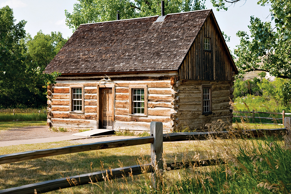
Teddy Roosevelt’s Maltese Cross log cabin, built from hand-hewn timbers and chinked with mortar
South Unit
Many people first see the park at the Painted Canyon Visitor Center, located just off I-94. The facility, perched at the top of a bluff, offers stunning views of the rugged, colorful badlands below; park staff can provide information and advice. The only access into the park from here is via hiking trails.
The national park entrance is located on Pacific Avenue, the main street through the historic town of Medora. At the visitor center you’ll find a small but very worthwhile museum devoted mostly to Theodore Roosevelt’s “free and hardy life” here in the 1880s. On display are his knife, telescope, and rifle, as well as the blood-stained shirt he was wearing during an attempted assassination in Milwaukee in 1912. (Undaunted, Roosevelt insisted on giving his scheduled 90-minute speech.) While you’re in the visitor center, take time to watch the introductory video, Refuge of the American Spirit.
Just outside of Medora stands the small Maltese Cross Cabin, where Roosevelt lived for a time, beginning in 1883. Originally located about 7 miles south, the cabin contains a few of Roosevelt’s personal items, including a traveling trunk. Roosevelt later built a dwelling at the Elkhorn Ranch, about 35 miles north (see here).
The South Unit’s 36-mile Scenic Loop Drive ranks as its major attraction, winding through a sampling of park terrain, from badlands to grasslands to bottomland, with tall cottonwood trees along the Little Missouri River. The route offers a number of panoramic overlooks and trailheads for short walks and longer treks. Bison can been seen anywhere along the way, as can feral horses, descendants of those that roamed the region when Roosevelt lived here. Mule deer, white-tailed deer, and elk are seen most often at dawn and dusk; pronghorn are occasionally spotted.
You’ll definitely want to stop at one of the roadside prairie-dog towns to watch the activities of these rodents and listen to their varied whistles and barks. As is the case with all wild animals (and especially with bison), don’t approach or try to feed them.
The Ridgeline Trail is a 0.6-mile loop with displays on park geology and park environmental factors, including fire and erosion. A short side road leads to the 0.8-mile Coal Vein Trail, site of a true natural oddity. Here, a vein of coal burned continuously from 1955 to 1977, literally baking the adjacent sand and clay into hardened rock.
Continuing around the Scenic Loop Drive, you’ll reach the Boicourt Overlook, with one of the finest vistas in the park. It’s a great place from which to watch sunsets. A short trail leads from the road to viewpoints. The bumpy, lumpy landscape below is the result of thousands of years of erosion washing away soil and softer rock and leaving scattered small buttes and hills formed of harder materials.
Where the road reaches its northernmost point and loops around back south, be sure to make the short climb on the Wind Canyon Trail to a wonderful perch on a rocky bluff overlooking a bend in the Little Missouri River. This may be the most scenic spot in the South Unit and makes for another fine sunset-viewing site.
If you’re looking for a longer walk that’s not too strenuous, consider the Jones Creek Trail, which traverses the territory between the east and west sides of the Scenic Loop Drive. It’s 3.5 miles in total, but unless you can arrange a shuttle from one trailhead to another, it’s best to simply walk the trail as far as you like and then double back to the beginning. Starting on the western end, note how the cooler, north-facing slopes on your right are more wooded than the drier, sunnier, south-facing slopes on your left.
Down in the bottomlands of the Little Missouri River, Peaceful Valley Ranch dates from the 1880s. It was a dude ranch from 1918 into the 1930s.
A good way to explore what is believed to be the third largest collection of petrified wood in the lower 48 states is to take a half-hour drive on Forest Service roads to a trailhead on the western edge of the South Unit visitor center, where you can get detailed directions. A high-clearance vehicle is recommended. Check with a ranger regarding weather and road conditions.
From the trailhead, it’s a 1.5-mile hike out and back to reach the area with petrified wood, though you can explore more on a 10-mile loop trail if you want. Fossils have also been found on this site, which was a swamp forest around 50 million years ago. It is illegal to take or disturb petrified wood, fossils, or any other natural features in the park.
Those with a special interest in Theodore Roosevelt and his legacy might want to make the trip to the Elkhorn Ranch Unit, site of the retreat where he lived at times from 1885 to 1892. Roosevelt called this his “home ranch,” and he spent much time sitting in a rocking chair on the veranda. Almost nothing remains of the house, but visitors can walk among the cottonwood trees just as Roosevelt did. Ask at the South Unit Visitor Center for road conditions and directions to the site, which is about 35 miles north of Medora and requires a drive of more than an hour over roads where a high-clearance vehicle is recommended.
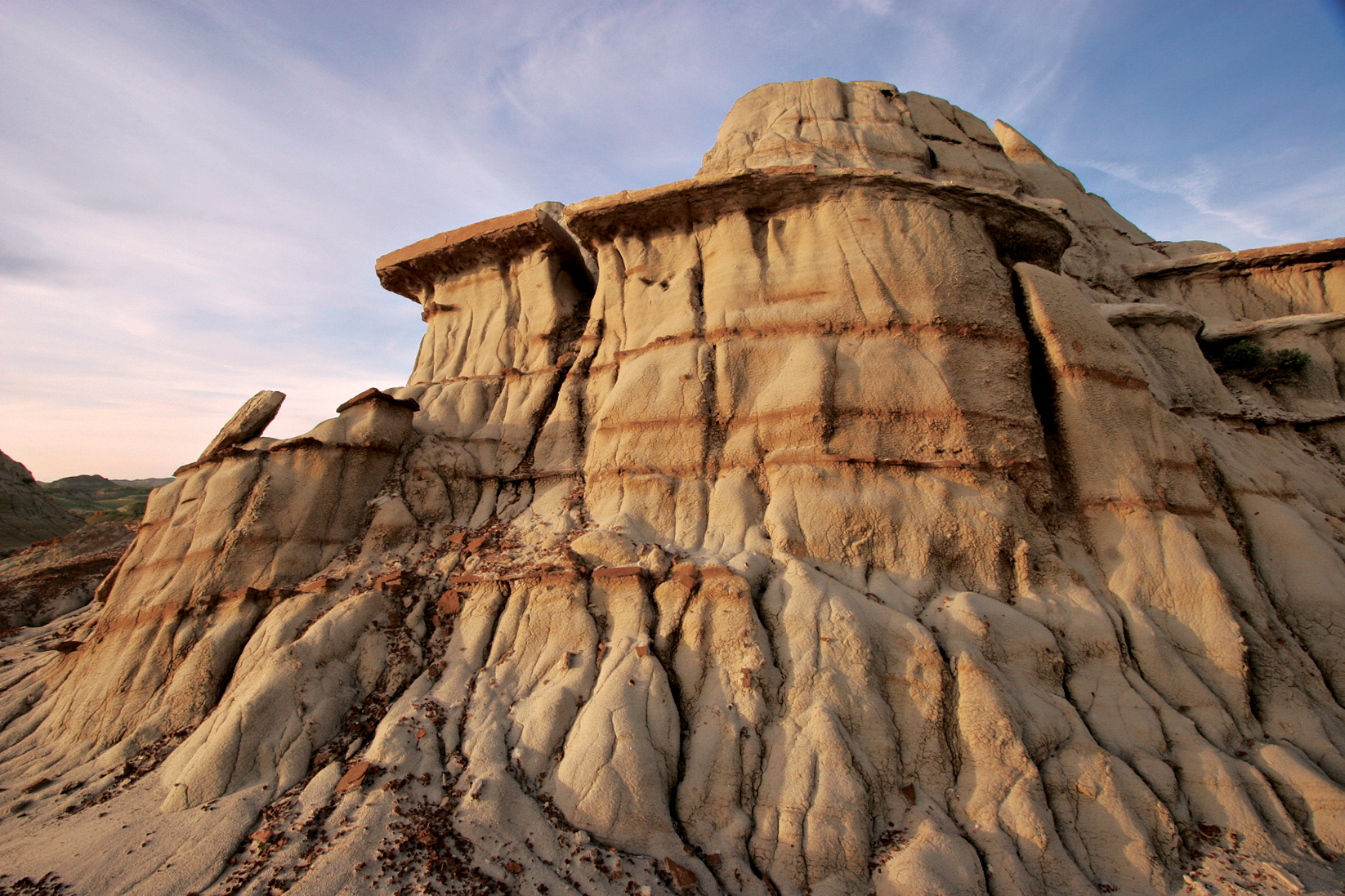
Rock formations of eroded mud buttes
Only a small percentage of visitors make the drive to this part of the park, located 54 miles north of I-94. That’s a shame, because the North Unit encompasses rewarding trails, picturesque expanses of prairie, and some of the best long-distance panoramas in the park.
Access to the area is via a scenic drive that winds 14 miles west from US 85, first following the Little Missouri River and then climbing to a grassy plateau. This is an out-and-back road, not a loop. Bison may be seen anywhere along the route.
As you enter the park, watch in the first 5 miles for longhorn cattle. The park keeps a herd of around 10 steers as a connection to the local ranching culture and the historic Long X Trail. This route was used by cowboys in the late 19th century to move cattle from southern states to the vast grasslands of North Dakota to the northern Great Plains for summer grazing.
A side road leads to the pleasant Juniper Campground, in the cottonwood trees beside the Little Missouri River. The 1.1-mile-loop Little Mo Nature Trail is a self-guided nature walk through this bottomland habitat. The first section of the trail is wheelchair accessible.
Be sure to make a stop across the main road from the campground entrance to see the collection of unusual cannonball concretions in the bluff. These rounded objects form when hard minerals are cemented together by water within softer sedimentary rock. The concretions becomes exposed when the surrounding material erodes away.
About 1.5 miles past the camp-ground is the trailhead for one of the park’s best short hikes. Pick up a brochure before walking the Caprock Coulee Nature Trail. You’ll learn a lot about geology and vegetation while enjoying scenic landscapes.
A coulee is a narrow valley; the trail winds among bluffs showing seams of lignite coal, volcanic bentonite clay, and examples of petrified wood. It’s 1.6 miles to the end of the nature trail and back. If you like, you can continue beyond that point to make a 4.1-mile loop, climbing to the River Bend Overlook before returning to the parking area.
While prairie-dog towns are easily seen in the South Unit, none are visible from the road in the North Unit. To reach one on foot, take the Buckhorn Trail from the Caprock Coulee trailhead and walk about a mile.
Watch for bighorn sheep in the next stretch of road as you continue to River Bend Overlook. The view here is renowned as one of the most photographed vistas in North Dakota. A historic Civilian Conservation Corps–era shelter sits on a high bluff overlooking a long bend in the Little Missouri River far below. (Note: Photographs are best taken in early morning or late afternoon rather than in the harsh light of midday.)
The scenic drive passes through prairie to reach its end at the Oxbow Overlook, with another splendid panorama of curves in the Little Missouri. For a different angle on this scene, walk the first mile or so of the Achenbach Trail down from the overlook to Sperati Point, the narrowest point on the Little Missouri River’s route through the badlands hills.
Information 
|
How to Get There From Bismarck, ND (about 130 miles east), take I-94 west to Medora. When to Go Summer is the season with highest visitation. Fall offers colorful foliage and fewer crowds. Winter brings an average of 30 total inches of snow and lows in the single digits. Portions of park roads may be closed in winter. Visitor Centers The park’s main visitor center is located at the entrance to the South Unit in Medora. The Painted Canyon Visitor Center is on I-94, 5 miles east of Medora. The North Unit Visitor Center is along the scenic drive west of US 85. All visitor centers are open year-round. |
Headquarters Box 7 Camping Cottonwood Campground in the South Unit (72 campsites) and Juniper Campground in the North Unit (50 campsites) are open year-round and accommodate tents, trailers, and RVs (no hookups). A free permit is required for backcountry camping. Lodging There are no lodgings in the park. Accommodations can be found in Medora, adjacent to the South Unit, and in Dickinson, 35 miles east. Medora Area Convention & Visitors Bureau (medorand.com; 701-623-4830). |
Upper Missouri River Breaks National Monument (BLM)
Fort Benton, Montana

▷ Home to a wide array of plant life, wildlife, geologic features, and recreational opportunities, the Upper Missouri River Breaks National Monument covers 375,000 acres in Montana. The 149-mile Wild and Scenic River flows through the monument. Visitors float the river, fish the waters, and marvel at the history of their surroundings—where Lewis and Clark themselves once roamed. Located 300 miles west of Theodore Roosevelt National Park via Mont. 200 W. blm.gov/mt/st/en/fo/umrbnm; 406-622-4000.
Little Missouri National Grassland
Dickerson, North Dakota

▷ Rugged and unspoiled, the Little Missouri National Grassland is one of four grasslands and two experimental forests that make up the Dakota Prairie Grassland. Ten area campgrounds (open late May through Labor Day) provide a base for hiking, horseback riding, and wildlife-watching. The grasslands surround Theodore Roosevelt National Park. Visitor information can be found in Dickinson, ND, off I-94. fs.usda.gov/recarea/dpg/recarea/?recid=79469recarea/?recid=79469; 701-250-4443.
Lostwood National Wildlife Refuge
North Dakota & Montana

▷ Ducks, marsh birds, grouse, hawks, Baird’s sparrows, and Sprague’s pipets as well as badgers and moose inhabit the mixed grasslands and wildflower fields of this Globally Important Bird Area. The 27,589 acres of Lostwood offer a scenic drive, grouse-viewing blind, nature trails, and cross-country skiing opportunities. Open year-round. Located off N. Dak. 8, about 135 miles northeast of Theodore Roosevelt National Park. fws.gov/refuge/lostwood; 701-848-2722.
Lake Ilo National Wildlife Refuge
West Central North Dakota

▷ A diverse array of wildlife and a waterfowl nesting area draw visitors to the Lake Ilo National Wildlife Refuge. As many as 100,000 birds fill the park in the fall. Nature hikes, archaeological exhibits, and scenic drives are options here; portions of the lake are open for fishing and boating. Located about 50 miles southeast of Theodore Roosevelt National Park via N. Dak. 200E. fws.gov/lakeilo; 701-548-8110.
Center, North Dakota

▷ One of the five state parks in North Dakota officially named a Lewis and Clark National Historic Trail Site, Cross Ranch is located along the Missouri River. Comprising 589 acres of rolling grasslands and river-bottom forests, Cross Ranch State Park is the perfect venue for both summer and winter recreational activities. Offered here are boating, camping, hiking, and cross-country skiing. Open year-round. Located 130 miles east of Theodore Roosevelt National Park via I–94. parkrec.nd.gov/parks/crsp/crsp; 701-794-3731.
Medora, North Dakota

▷ Located in the heart of the North Dakota Badlands, Sully Creek State Park is one of North Dakota’s smallest state’s parks, but there’s still lots to do: horseback riding, canoeing, hiking, biking, and camping. Get to experience the Badlands up close. Open from early April through late Nov. Surrounded by Theodore Roosevelt National Park, 2 miles south of Medora, ND, off I-94E. parkrec.nd.gov/parks/scsp/scsp; 701-623-2024.
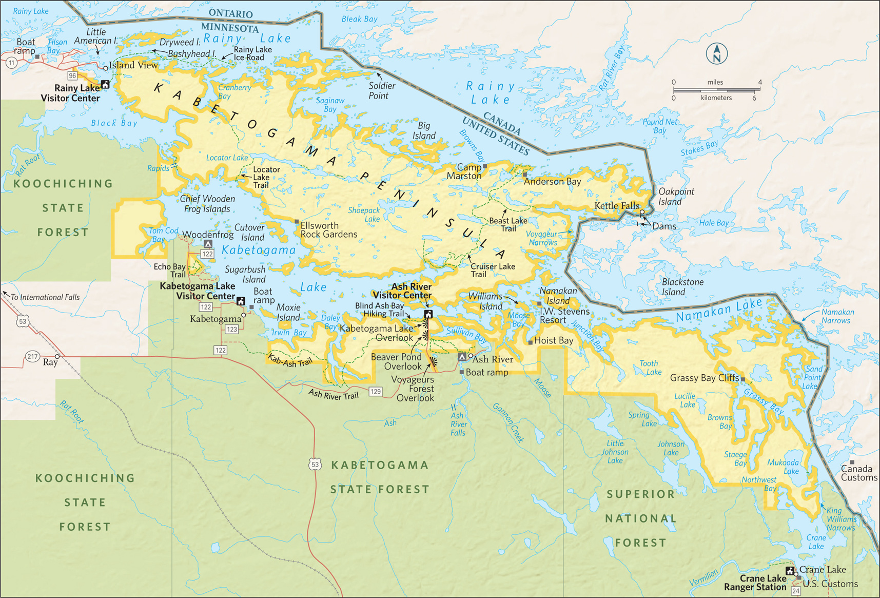
Lake Kabetogama
Minnesota
Established April 8, 1975
218,054 acres
For a well-prepared visitor, Voyageurs National Park can be paradise. Imagine camping on your own private island, cooking freshly caught walleye for dinner, and waking in the morning to the sound of loons and the sight of a bald eagle flying over the sparkling water of a beautiful lake—all set within the legendary North Woods of Minnesota.
This scene and similar idyllic interludes await travelers to Voyageurs. The park is 40 percent water, comprising four major lakes—Rainy, Kabetogama, Namakan, and Sand Point—and dozens of smaller ones. Relatively little of the park is accessible without a boat.
Three visitor centers and a few hiking trails are found on the mainland. Otherwise, Voyageurs is a place of water-centered attractions and activities, with 655 miles of shoreline, more than 500 islands, several historic sites, and secluded campsites on islands as well as on lakeshores. (All campsites in the park can be reached by boat only.)
Many Voyageurs visitors are Minnesotans who use their own kayaks, canoes, motorboats, and houseboats to cruise the lakes. This doesn’t mean that those without a boat can’t enjoy the park. Rangers lead seasonal boat tours, and local firms rent a range of watercraft, including houseboats.
Voyageurs took its name from the famed 18th-century French Canadian adventurers who paddled canoes along lakes and rivers, transporting trade goods westward and furs eastward between Montreal and the vast inland forests of Canada. So influential was this trade route that a 1783 treaty incorporated part of it as the boundary between the United States and Canada.
Fifty-six miles of the former trade route pass through Voyageurs. Boaters need to be aware of their location to avoid crossing the international boundary without the proper permits. (For international permits, 807-274-3655.)
As for the land, in places volcanic bedrock of the Canadian Shield has been exposed by glacial action, revealing greenstone, a type of metamorphosed basalt 2.7 billion years old. Greenstone, granite, schist, and other rocks form picturesque bluffs.
Glaciers retreated about 10,000 years ago, recently enough that only a thin layer of soil has formed atop the rock. The vast stands of white pine that once covered the land are gone, cut by timber operations more than a century ago.
The forest that has grown up represents a blend of boreal woodland and southern temperature forest. In the autumn, the green of conifers such as pine, fir, spruce, and white cedar is complemented by the colorful foliage of maple, birch, aspen, and oak.
White-tailed deer, wolves, and moose roam the woods; otters, beavers, and muskrats make homes near lakes and streams. Eagles and loons are commonly spotted on the water. Campers must use bear-proof containers for food storage to discourage visits from the plentiful black bears.
► HOW TO VISIT
Plan for at least a two-day visit. If you don’t bring a boat and don’t plan to rent one, check the schedule of ranger-led boat tours and programs ahead of time. (Otherwise you could arrive and find there’s little to do other than hike.) Be aware that the park has three visitor centers that are separated by about 50 highway miles; boat tours and other activities vary among them. If you do plan to take a boat to a campsite, remember that sites must be reserved in advance (recreation.gov; 877-444-6777). This ensures that everyone who sets out across a lake will have a place to stay, and eliminates the competition for sites between those in motorized craft and paddlers.
A good navigational map is vital for boating these lakes, to learn the location of submerged rocks and other hazards. Mobile phones work intermittently.
While some campsites are located on fairly protected bays, others require a trip across lake expanses where sudden bad weather can create waves up to four feet. A radio that receives weather alerts is a good idea. A marine-band radio is also helpful.
Visitors interested in history should join a boat tour to Kettle Falls or Little American Island. The North Canoe Voyage, a paddling trip (fee) aboard a reproduction of a voyageurs craft, is fun for adults and children five and older. On the mainland, the Blind Ash Bay Hiking Trail near the Ash River Visitor Center provides a good introduction to the North Woods environment.
On the Kabetogama Peninsula, the park has canoes available for rent. You must make a reservation and get a key from the visitor center. Then, in your own boat (or using a guide), you make your way to a trailhead. Next, you hike to an inland lake (trails range from very short to several miles), unlock the canoe, and paddle to a campsite. Depending on where or when you go, this can assure you of a peaceful and solitary adventure in the backcountry wilderness.
(To prevent the spread of invasive species, private watercraft can’t be transported to inland lakes.)

A kayaker watches a rainbow arc over the lake.
The Rainy Lake Visitor Center, 11 miles east of International Falls, is the only visitor center open year-round. It offers exhibits on nature and history, a bookstore, a video introducing the park, and weather updates plus advice from rangers. This is where you sign up for a variety of ranger-led programs. In addition, this is the center for winter activities in the park (see above).
The short, easy Ethno-botanical Garden Trail, outside the visitor center, tells of the relationship between the Ojibwe Indians and their environment, including the plants they used for food and medicine.
The 1.7-mile Oberholtzer Trail begins steps from the visitor center and winds through mixed woodland to two overlooks of marsh and forest.
Several ranger-led boat tours leave from the Rainy Lake dock. The 1.5-hour Gold Mine Tour visits Little American Island, site of a short-lived gold-mining boom in the 1890s. Mining equipment can be seen on a short walk. About a mile east is Bushyhead Island, where a mineshaft is carved into the rock.
The 2.5-hour Grand Tour allows ample time for wildlife-watching (usually with views of active bald eagle nests) and also visits Little American Island. On the 1.5-hour North Canoe Voyage, participants help paddle a 26-foot-long reproduction of the kind of canoe used by the original voyageurs to transport trade goods, including beaver pelts. During the outing, tour leaders share details of 18th-century life here. The 2-hour Family Canoe Trip is an easy wildlife-spotting ride around calm waters. It is suitable even for beginning paddlers age five and older. Boat tours also depart on certain days from Rainy Lake to Kettle Falls.
Although this lake is large—60 miles long and 12 miles wide—you can safely explore it on your own.
The Kabetogama Lake Visitor Center, about 28 miles southeast of International Falls, on Rte. 122, is open from late May through late September, and provides interactive exhibits, a park video, a bookstore, and an information desk. Boat tours to several of the park’s most interesting destinations begin here. Like all the visitor centers, this one is an embarkation point for private boaters heading to various campsites, picnic areas, and historic sites around the lakes.
One of the most fascinating historic sites in the park is Kettle Falls, located in the narrows where Namakan Lake flows into Rainy Lake. A small dam has taken the place of the falls here, but the main attraction is the circa 1910 Kettle Falls Hotel.
Now operated by a concessioner, this inn, which is on the National Register of Historic Places, offers meals and lodging in rustic rooms. The hotel underwent restoration in the 1980s, in part to correct the foundation problems that had given it the nickname “Tiltin’ Hilton.” (The sloping floor in the bar was left intact for old times’ sake.) The 5.5-hour Kettle Falls Cruise includes time for lunch at the hotel and a short tour of the dam.
Another of the park’s historic destinations is Hoist Bay, reached on a 2.5-hour boat tour from the Kabetogama Lake Visitor Center. Once the site of a busy logging camp, it was later rebuilt as a resort, which operated until 1973. Cabins, the kitchen, the boat house, and an ice house are among the structures still standing.
The quirkiest attraction on the shore of Lake Kabetogama is Ellsworth Rock Gardens, which can be visited on a 2-hour cruise. A Chicago couple spent summers here before the national park was established. Over a span of 22 years, the husband created an odd but appealing sculpture garden on a rock bluff—a charmingly random array of abstract forms where visitors can put their imaginations to good use. This makes a great spot for a picnic or just to relax for a while.
Voyageurs National Park doesn’t have a large variety of loop hikes, but one can be found 3 miles west of the Kabetogama Lake Visitor Center, off Rte. 122.
The 2.5-mile Echo Bay Trail passes through attractive woods and reaches an overlook at a wetland that’s good for wildlife-watching.
The Ash River Visitor Center, about 37 miles southeast of International Falls, is open from late May through late September. The visitor center is housed in a historic lodge, and the launch area here is popular with boaters. For kayakers and canoeists, Ash River is close to an area of small bays and narrow passages between lakes Kabetogama and Namakan, providing sheltered water on which to paddle to campsites.
A popular short trail is the Blind Ash Bay Hiking Trail, a 2.8-mile loop through a mixed hardwood-conifer forest to a small bay lined with cattails. Not far away, a very short walk leads to a viewing platform at the Beaver Pond Overlook, a great place to sit, relax, and look—not just for beaver but for moose (the largest and most impressive creature here), deer, waterfowl, and other wildlife.
The 28-mile Kab-Ash Trail, which runs roughly parallel to the southern shore of Kabetogama Lake, serves as a hiking trail in summer and an ungroomed cross-country ski trail in winter. Several trailheads allow access to various sections for shorter hikes through forest and wetlands.
Information 
|
How to Get There From Duluth, MN (About 160 miles south), take US 53 north to the International Falls area. When to Go The main park season runs from mid-May to late Sept., when the greatest number of ranger-led programs are offered. Peak visitation comes around July 4. Many visitors enjoy mid-Sept. for the lessened crowds and beautiful fall foliage. Winters are snowy and very cold; the average low in Jan. is −8°F. Visitor Centers Rainy Lake, the park’s year-round visitor center, is located 11 miles east of International Falls; take Minn. 11 to Rte. 96. The Kabetogama Lake and Ash River visitor centers are southeast of International Falls off US 53. These sites are open from late May through late Sept. |
Headquarters 360 Hwy. 11 East Camping All campsites (some 20 day sites and 279 campsites) require boat access; a permit is required for all camping and overnight use (recreation.gov; 877-444-6777). Drive-up camping is available at nearby state-run sites and at private sites. Lodging The only lodging in the park is the concessioner-run Kettle Falls Hotel (kettlefallshotel.com), which can be reached only by boat. There are numerous lodging opportunities in International Falls and Orr, and dozens of lakeside resorts in areas near the park boundary. For info on places to stay outside the park: dvnpmn.com. Also check rainylake.org and kabetogama.com. |

A limestone cave’s calcite crystal formations
South Dakota
Established January 9, 1903
33,851 acres
When rangers at Wind Cave National Park describe it as the “best of both worlds,” they are referring to the realms below and above the Earth’s surface. Underground lies one of the world’s most complex and unusual caves; above is a globally significant expanse of mixed-grass prairie, home to wildlife—from massive bison to playful prairie dogs to sky blue mountain bluebirds.
It was distinctive geology that inspired President Theodore Roosevelt to designate Wind Cave America’s eighth national park—the first set aside to protect a cave. In 1913, bison, elk, and pronghorn were reintroduced. (Large animals were wiped out by hunters in the 19th century.) Today, these reintroduced animals and many other wildlife species thrive in this prairie-woodland ecosystem.
The word “cave” is part of the park’s name. Indeed, a subterranean tour is a must during a visit to this Black Hills site. Those who walk through the scenic subterranean passageways of Wind Cave—one of the world’s longest—can admire a trove of formations, including abundant displays of boxwork, an unusual formation composed of thin calcite structures resembling honeycombs.
But a visit to Wind Cave shouldn’t end with a return to the surface.
The park’s mixed-grass prairie is an ecosystem that has largely disappeared elsewhere in North America in the face of agriculture, ranching, and other development. Drive along one of the park’s roads; take a walk on one of its trails, which range from easygoing to backcountry strenuous.
From many viewpoints in the park, the land seems little changed from the days when the Lakota made it their home. Bison and pronghorn graze on rolling grassland; a coyote lopes through a prairie-dog colony, hoping for an easy meal; a golden eagle soars over a distant ridge, where ponderosa pines separate the prairie and the deep blue sky. Some 60 percent of the park is open grassland, aiding wildlife-spotters.
► HOW TO VISIT
You can experience the park in one or two days. Wind Cave’s visitor center is located off US 385, in the southern part of the park and houses exhibits on cave geology, wildlife, and park history. A film entitled Wind Cave: One Park, Two Worlds is shown regularly. Visitors may enter Wind Cave only on one of the many ranger-guided tours. All tours leave from the visitor center.
If you have time for a second cave tour, take the Natural Entrance Tour, the Fairgrounds Tour, or the Garden of Eden Tour (shortest and easiest).
For the best chance to see bison, drive Park Roads 5 and 6. Prairie dogs are usually easy to see along US 385 and S. Dak. 87. The Rankin Ridge Nature Trail offers fine views of the surrounding landscape, while the Wind Cave Canyon Trail offers an easy stroll into the park’s interior.

On the Surface
Quite often, bison (there are some 400 in the park) can be seen along US 385, which runs north-south through the park. Close to extinction in the 19th century, the result of hunting, bison were reintroduced shortly after the park’s establishment.
Bison, pronghorn, mule deer, and white-tailed deer are commonly seen; elk are harder to spot. Best chances for a sighting: dawn and dusk at the edge of the ponderosa pine and aspen woodlands that are scattered among the grasslands. On a smaller note, prairie-dog towns, with their distinctive burrows, can be seen along park roads.
Two unpaved roads, numbered 5 and 6, run for several miles through the eastern part of the park and make excellent wildlife drives. Here you may be lucky and spot a coyote, badger, or porcupine, along with birds such as western meadowlark, spotted towhee, black-billed magpie, burrowing owl, and golden eagle.
Wind Cave includes about 30 miles of hiking trails, offering the chance to see its prairies and forests closely. A favorite is the moderately strenuous Rankin Ridge Nature Trail, a 1-mile loop that leads up to a fire tower at the park’s highest point. The views are wide-ranging here; at times you can see all the way to Badlands National Park, some 40 miles to the east.
The less strenuous Elk Mountain Nature Trail, also about a mile, interprets the ecological zone where ponderosa pine forest meets the prairie.
An excellent longer hike combines portions of the Centennial, Highland Creek, and Lookout Point Trails for a 4.5-mile loop. The trailhead is on S. Dak. 87, about a half-mile north of US 385, and the trek passes through a variety of habitats. An easier hike, Wind Cave Canyon (1.8 miles), follows a road past low bluffs with scattered trees and shrubs; it’s a fine walk for bird-watching.
Wind Cave
American Indians knew of the cave; some tribes continue to consider it a sacred site. The first recorded entry to the cave took place in 1881, after local settlers noticed air rushing into and out of the entrance (the “wind” of the park’s name). Soon, a tourism business, the Wonderful Wind Cave Improvement Company, sprung up to guide tourists through cave passageways. In those days, visitors could buy a piece of boxwork formation for 15 cents. (For the sake of resource management, at least, it’s a good thing Wind Cave was declared a national park, where it is forbidden to remove any natural items.)
The caverns were formed in limestone deposited on a seafloor some 350 million years ago. Masses of gypsum formed within the limestone. When the gypsum swelled, small cracks formed. More gypsum filled the cracks, and mineral-rich water worked to convert the gypsum into crystal-like calcite.
This process is reflected in Wind Cave’s most distinctive feature, its famed boxwork. Over time, water dissolved large passageways that form the modern cave, as well as the softer limestone between the calcite, leaving honeycomblike crystal “fins” called boxwork. These delicate formations are as picturesque as they are rare. Wind Cave contains about 95 percent of the world’s known boxwood. Because Wind Cave is drier than many caves, it has few stalagmites and stalactites, which are formed as the result of water dripping through limestone.
To get a good sense of the three-dimensional complexity of the cave, consider that 143 miles of passages lie beneath only 1.2 square miles of surface. Tour routes cover only a fraction of the cave, which twists through several different levels. Summer visitors can choose from five tour options; tours are more limited from September to Memorial Day weekend.
The Garden of Eden Tour is the least strenuous, at about 0.25 mile, with 150 steps. You enter and leave the cave via elevator and along the tour route see boxwork, popcorn (clusters of small round formations), and flowstone (calcite deposited by a thin sheet of running water).
The Natural Entrance Tour passes by the hole in the ground where the first explorers entered before descending 115 steps to begin its 0.3-mile route. It features abundant boxwork as well as popcorn and frostwork (delicate branching crystals).
The 0.5-mile Fairgrounds Tour includes 450 steps as it passes through two levels of the cave, also with lots of typical stone formations.
Wind Cave offers two specialized tours: the 1-mile Candlelight Tour through a less developed section, during which illumination comes from candles in buckets carried by participants, and the strenuous, 0.5-mile Wild Cave Tour, in which visitors put on helmets, kneepads, and headlamps to crawl through tight passageways. Reservations are recommended for the Candlelight Tour and required for the Wild Cave Tour.

Dames rocket
Information 
|
How to Get There From Rapid City, SD (about 60 miles north), take US 16 west to US 385 and go south to the park. When to Go Summer and early fall are the most popular seasons. Cave tours are on a first-come, first-served basis, and there can be waits in summer. Visitor Center The visitor center, off US 385, is open year-round. Headquarters 26611 US Hwy. 385 |
Camping The Elk Mountain Campground (46 sites) is open year-round; in winter, services are limited and water is available only at the visitor center. Sites are occupied on a first-come, first-served basis. Backcountry camping requires a free permit from the visitor center. Lodging There is no lodging in the park, but lodging is available in the towns of Custer (visitcuster.com; 605-673-2244), 20 miles north, and Hot Springs (hotsprings-sd.com) 13 miles south. |