Century plant (Agave havardiana) in Chicos Basin, Big Bend National Park

The four national parks of the South Central region offer scenery ranging from historical and underground to high and rugged … and then there are the glorious, natural warm baths.
Water sculpted these landscapes. A reef from an ancient sea forms the 40-mile-long Guadalupe Mountain chain. Hikers can take what feels like trips back in time by climbing up to the pine-fir forests that cloak the cooler, moister peaks of Texas’ Guadalupe Mountains National Park. This type of forest probably covered the region at the end of the last Ice Age, when early peoples hunted camels, mammoths, and four-horned antelope.
The seeping of water over millions of years created the cool, dark world of New Mexico’s Carlsbad Caverns, with more than 30 miles of mapped passageways. The flight of bats—more than 5,000 per minute speeding out of the cave in search of insects to eat—is a thrilling nightly drama here.
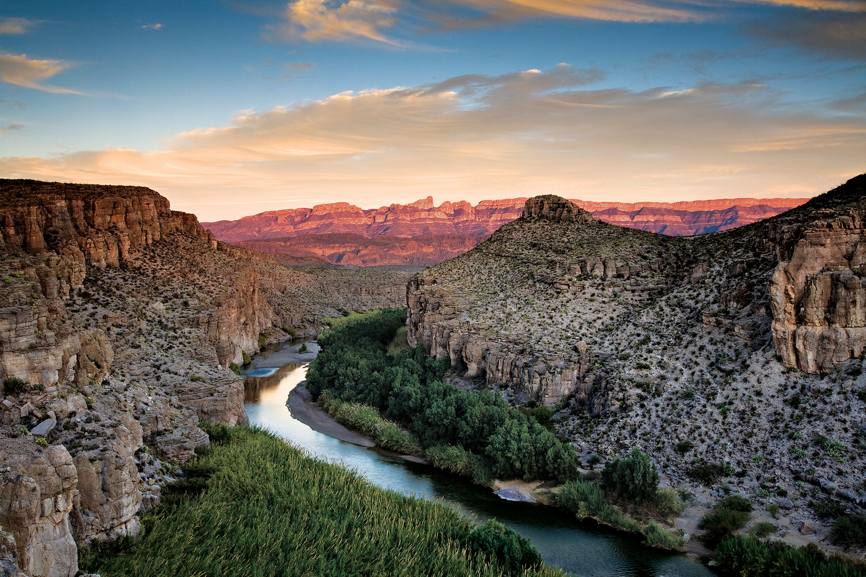
Rivers etched out the dramatic Texas canyons of Big Bend and flash floods still tumble boulders from the steep Chisos mountaintops, continuing to rearrange the Texas scenery. Paleontologists have unearthed fossils of many creatures here, including the Big Bend pterosaur, the largest animal ever to fly.
It was the bubbling heated waters that gave rise to the health culture that surrounds diminutive Hot Springs National Park, which draws to Arkansas visitors in search of a restorative soak and a touch of history. In its heyday, America’s Spa City counted Babe Ruth and Al Capone among its regulars. Most of the dozens of thermal springs lead into the plumbing of the Arkansas national park’s bathhouses.
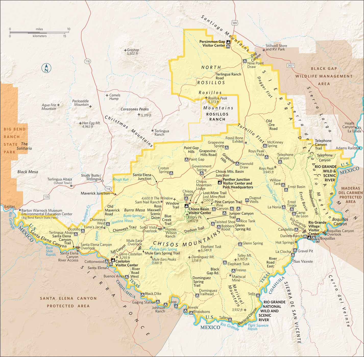
The Rio Grande
Texas
Established June 12, 1944
801,163 acres
Vast, diverse, and remote, Big Bend National Park inspires passion among its fans. Few visit on a whim—it’s not on the way to anywhere else. Those who make the journey are richly rewarded; many leave with a new favorite among the national parks.
Encompassing more than 1,200 square miles of western Texas, the park is located where the Rio Grande makes a “big bend” southward and back north again. The river forms the U.S.–Mexican border for 118 miles. Along the way it flows through some of the most spectacular canyons in North America.
Most of Big Bend is Chihuahuan Desert, a ruggedly beautiful terrain that offers a glorious display of blooming wildflowers when sufficient rain falls. In the center of the park rise the Chisos Mountains, volcanic highlands crowned by 7,832-foot Emory Peak.
It’s this juxtaposition of environments—river, desert, and mountains—that gives Big Bend its broad diversity of plants and animals. Cottonwoods and willows border the Rio Grande; barrel cactus, ocotillo, and creosote bush grow in the Chihuahuan Desert; and woodlands of pine and oak cover the slopes of the Chisos. The wildlife ranges from beaver in the riparian corridor to mule deer and javelina in the foothills to black bear in the mountains. More species of birds, bats, reptiles, butterflies, scorpions, ants, and cacti have been documented here than in any other national park.
Geologists revere Big Bend as a showcase of Earth’s tumultuous past. You can see sandstone rocks 500 million years old; an outlying segment of the Rocky Mountains dating back around 100 million years; the Chisos Mountains, created by volcanic eruptions about 35 million years ago; and the Rio Grande, which took its present course less than two million years ago. Paleontologists studying the area’s ancient past have discovered a fascinating and scientifically important array of fossilized dinosaurs and other animals.
Big Bend National Park has been designated a UNESCO Biosphere Reserve; a stretch of the Rio Grande is a National Wild and Scenic River. These honors provide official recognition of the park’s unspoiled wilderness and biodiversity.
► HOW TO VISIT
It’s one thing to learn that Big Bend is a huge park. It’s another thing to realize that it takes around two hours to drive from Rio Grande Village to “nearby” Santa Elena Canyon. Given its size and scope, you could easily spend a week here.
Stop at the Panther Junction Visitor Center, 28 miles south of the park’s north entrance, to see an orientation video, study the 3-D model of the park, get maps and advice, and walk the short nature trail and learn about desert plants.
Drive to the Chisos Basin and admire the peaks of the Chisos Mountains. Then take the Ross Maxwell Scenic Drive to see the chasm of Santa Elena Canyon.
If you have more time, go bird-watching at Rio Grande Village and soak in the nearby hot spring. If you are equipped with the proper gear and plenty of water, walk a trail—perhaps the 3.8-mile round-trip Mule Ears Spring Trail in the desert or the 1.8-mile Chisos Basin Loop Trail in the mountains. For a wilderness river adventure, which can run from two days up to ten or more, check with local outfitters about a canoe or raft trip on the Rio Grande.
If you’re flying to the area and renting a car, consider getting a high-clearance vehicle. This will open up opportunities to travel some of the park’s primitive roads to see true backcountry and visit sites such as old villages and abandoned mines.
Gasoline is available in the park and at Study Butte on its western border, but it’s a long way between stations. Make sure your vehicle is in good condition, and check your fuel gauge often.

Overlooking the Mexican border
The Chisos Mountains
Though they comprise only a relatively small part of Big Bend, the Chisos are the focus of much visitor activity. The Chisos Mountain Lodge, a restaurant, a campground, and a ranger station are located here, as are the trailheads of several of the park’s most popular trails.
The Basin access road heads south 3 miles west of the Panther Junction Visitor Center. On its 6-mile route up Green Gulch, the road ascends from desert to woodland. Correspondingly, the vegetation goes from grassland dotted with cholla cactus and the tall stalks of sotol to increasingly dense woodland of oak and pine.
At Panther Pass, the Lost Mine Trail heads off the road to the east. It’s a 4.8-mile hike round-trip, but by walking just the first mile you’ll find some excellent vistas, including a view of the lava-capped mesa called Casa Grande. Interpretive signs make this hike a good introduction to Chisos Mountains ecology.
Beyond Panther Pass the road descends to the Basin, the focus of highland activities. The elevation here is 5,400 feet. Bluffs surround the Basin except to the west, where the V-shaped slot called the Window offers a perfect spot through which to see the sun set. The very easy Window View Trail (0.3 mile round-trip) offers a nice vista; the considerably longer Window Trail (5.6 miles round-trip) leads down to the spot where water drains out of the Basin.
All the peaks around the Basin, including prominent Casa Grande, resulted from volcanic activity about 35 million years ago, when ash spewed from vents and magma rose from deep within the Earth, cooling into igneous rock.
The Chisos Basin Loop Trail, which begins behind the Chisos Basin store, is a 1.8-mile walk requiring only moderate effort while offering good views of the Window and the rock spires called the Pinnacles. Woodland provides shade much of the way.
To climb 7,832-foot Emory Peak, take the steep Pinnacles Trail and the spur to the summit—a strenuous 10.5-mile round-trip. For a fine loop hike that captures the essence of the Chisos, take the Pinnacles Trail to Boot Canyon (named for a distinctively shaped rock column, like an upside-down cowboy boot) and continue via the Colima and South Rim Trails to descend back to the Basin via Laguna Meadow.
During this strenuous 10-mile hike you might spot the Colima warbler, which nests in the United States only in and around Boot Canyon. Avid birders come from far and wide to try to see this small gray migratory songbird, present April through summer.
In the Chisos, you could see birds such as acorn woodpecker, Mexican jay, and western tanager; mammals include javelina, black bears, mountain lions, and the small Carmen Mountains white-tailed deer. Trees in the uplands include Texas madrone, alligator juniper, Arizona cypress, bigtooth maple, several species of oaks, and even a few aspen trees on Emory Peak. The southernmost ponderosa pines in the United States grow in the Chisos.
Visitors are bound to notice the large Havard agave, which spends most of its life as a cluster of thick, spine-tipped leaves. At maturity, the plant sends up a thick stalk that can be 20 feet tall; side branches have masses of yellow flowers, which attract hummingbirds and orioles, along with other wildlife. After flowering once, the plant dies. Havard agave is often called century plant, but it actually lives between 20 and 50 years.
Given the black bears and mountain lions that roam the uplands, hikers are cautioned to keep their distance. Park personnel at the visitor centers are at the ready to provide further recommendations regarding staying safe.

Park hot springs
Rio Grande Village
As you drive across the desert to Rio Grande Village (20 miles east of Panther Junction), the imposing cliffs of the Sierra Del Carmen Mountains loom before you. At Rio Grande Village you’ll find a visitor center (closed in summer), a campground, and a convenience store that sells gasoline.
Here you’re more than a mile lower than the summit of Emory Peak; it can be very hot here in late spring and summer, as in other places along the river.
Bird-watchers love the area along the Rio Grande for its tall cottonwood trees and shrubby riparian vegetation, home to such notable bird species as the gray hawk, common black hawk, vermillion flycatcher, and painted bunting. Even people with little or no interest in birds can’t help but notice the roadrunners hanging around the campground—sometimes running, usually walking, but seldom flying.
To see more wildlife, walk the short, easy Rio Grande Village Nature Trail, which in part is a boardwalk over spring-fed wetlands.
Farther east, a 4-mile dead-end road leads to Boquillas Canyon, where a trail enters the mouth of this impressive gorge, carved by the erosive power of the Rio Grande. The haunting song of the canyon wren echoes off the tall cliffs, and golden eagles occasionally soar overhead.
You can walk only a short distance into Boquillas Canyon; the way to see more of it is on a float trip through its entire 33-mile length—there are no take-out points along the way.
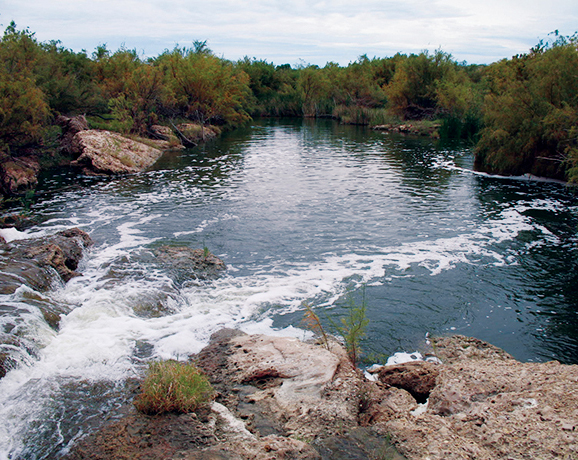
It’s worth the short side trip off the main road to Rio Grande Village to visit Langford Hot Springs, the remains of a small resort where travelers came to soak in “healing waters” in the early 20th century, before the park was established. Healing or not, the warm spring water here feels great after a day of hiking, and locals maintain there’s nothing better than to lie back and enjoy this natural hot tub under a starry sky.
For years, Big Bend visitors enjoyed crossing the Rio Grande to visit the small town of Boquillas, Mexico, across from Rio Grande Village. Security regulations stopped the activity for a while, but once again it’s possible to take a boat across (fee) and have a beverage and snack in a cantina and buy souvenirs. Ask a park ranger about the border crossing, which is possible only on designated days and at limited times. You will need your passport.
This route (a portion of Tex. 118) heads south off the main east-west park road 13 miles west of Panther Junction. It winds across rugged desert landscape for 30 miles, connecting several noteworthy destinations.
Ruins at the Sam Nail Ranch provide a glimpse into the frontier days of the Big Bend region. Old adobe walls remain from a house built by brothers Sam and Jim Nail in 1916. When Sam married Nena Burnam two years later, it became their home, where they raised hogs, chickens, vegetables, and fruit. A windmill still turns in the breeze. The mature trees attract a wide variety of birds.
Pull off at Homer Wilson Ranch, where a short walk leads to buildings of what was once a large sheep ranch. A hike of a mile or so up the Blue Creek Trail reveals an array of red-rock pillars, spires, and hoodoos; the scenery is well worth the modest effort. (This trail was originally established as a thoroughfare for moving sheep back and forth from summer grazing areas in the Chisos Mountains to lowlands in winter.)
A little farther down the drive, take the side road to Mule Ears Overlook for a view of this distinctive formation, composed of solidified volcanic magma that flowed into rock fractures and was exposed by erosion. Get closer by hiking the 1.9-mile Mule Ears Spring Trail to an oasis-like desert spring.
Watch for the bright white volcanic material lining the road at Tuff Canyon, before you pass Cerro Castellan peak, with colorful slopes of volcanic rocks and ash deposits.
There’s a seasonal visitor center at Castolon as well as a store located at the site of a frontier-era trading post and a former military station (from the days of border disputes between the U.S. and Mexico). A bit farther on is Cottonwood Campground. This area was once a center for cotton and vegetable farming, which continued for many years, even after the national park was established. The road winds 8 more miles through the Rio Grande lowlands to Santa Elena Canyon, one of Big Bend’s most impressive sights. Here the Rio Grande flows through a chasm in Mesa de Anguila, with sheer cliffs up to 1,500 feet high.
A 1.7-mile round-trip trail that leads into the canyon can be reached by crossing Terlingua Creek from the parking area. The trail climbs a bit as it enters the canyon, then gradually slopes down to river level.
Limestone cliffs rise high above as you explore Santa Elena Canyon, a 7-mile-long chasm. Look down to maybe spot the rafts and canoes of river floaters below.
It wasn’t the Rio Grande that sculpted this area; the river followed this route before the huge block of the Earth’s surface through which it flows was uplifted. As the land gradually rose over millions of years, the sediment-filled river eroded downward, eventually carving the canyon.
Rather than retracing your route on the Maxwell Scenic Drive, you can take the 14-mile unpaved Old Maverick Road to Maverick Junction on the park’s western border. The road passes several historic sites and lots of wide-open space with striking views.
Make a short detour west to see the ruins of the historic village of Terlingua Abajo. The Old Maverick Road is usually passable for regular passenger vehicles, but the going can be difficult after rains, at which time it is necessary to have a four-wheel-drive vehicle. Check with a ranger at any visitor center for weather and road information.
Rio Grande Wild & Scenic River
A 196-mile stretch of this legendary stream has been designated the Rio Grande Wild and Scenic River; 69 miles lie within Big Bend National Park.
The river flows through three awe-inspiring canyons—Santa Elena, Mariscal, and Boquillas. A raft, canoe, or kayak trip beneath the towering walls of the river gorges can be a wonderful experience, but it’s not something to be undertaken without planning and full knowledge of possible hazards. Depending on water level, rapids can range to Class IV. Rugged terrain and limited road access mean that help could be a very long time in arriving in an emergency.
The number of people running the river is restricted; permits are required for day use and overnight outings. The park website has details.
While private trips are allowed, the easiest way to traverse the Rio Grande’s canyons is by taking a float trip with an outfitter company, which will handle permits, equipment, and the often complicated necessity of shuttling river runners between put-in and take-out points.
Trips can range from one day to ten days or more, and outfitters can advise floaters about the appropriate segments for their ability levels. The park newspaper and website offer a list of companies approved to run river trips.
Information 
|
How to Get There From Dallas, TX (about 550 miles northeast), take I-20 west to Monahans, then go south on Tex. 18 and US 385. From El Paso, TX (about 300 miles northwest), take I-10 east to Van Horn and then US 90 east to US 385. When to Go Temperatures are most pleasant from fall through spring. Summer is very hot, although cooler in the Chisos Mountains. Campgrounds and lodgings fill up quickly for Thanksgiving week, around Christmas, and during spring break. Visitor Centers Visitor centers at Panther Junction and Chisos Basin are open year-round. The Persimmon Gap visitor center is open most of the year; Castolon and Rio Grande Village are open Nov. through April. |
Headquarters P.O. Box 129 Camping Sites at all three developed campgrounds—Chisos Basin (60 sites), Cottonwood (24 sites), and Rio Grande Village (100 sites)—can be reserved mid-Nov.–mid-April (recreation.gov; 877-444-6777) and require a permit (fee). For backcountry camping (fee), permits must be obtained in person at the Panther Junction Visitor Center. Lodging In Chisos Basin, the Chisos Mountains Lodge is a concessioner-operated facility (chisosmountainslodge.com; 877-386-4383). Hotels are located in Study Butte, Terlingua, and Lajitas. For more information: Brewster County Tourism Council (visitbigbend.com). |

Left Hand Tunnel tour
New Mexico
Established May 14, 1930
46,766 acres
With the words “I shall never forget the feeling of aweness it gave me” pioneer Carlsbad Caverns explorer Jim White recalled the time around 1898 when he first saw the newly discovered cave by the flickering light of a kerosene lantern. Carlsbad Caverns National Park continues to awe.
For more than 20 years, Jim White pushed farther into the cave, constantly trying to publicize this underground wonderland in remote southeastern New Mexico. In 1924, he guided a special National Geographic Society expedition into the caverns. The resulting report in the magazine used language a bit more formal to express a superlative judgment: “For spacious chambers, for variety and beauty of multitudinous natural decorations, and for general scenic quality, it is king of its kind.”
King, indeed: Carlsbad is one of the most famous caves in the world, and the various languages heard on a walk through its passages testify to its wide-ranging appeal.
The story behind the cave’s spectacular sights begins around 260 million years ago, when sea creatures formed a 400-mile-long U-shaped limestone reef along the shores of a broad bay. After the ocean receded, the reef was buried beneath sedimentary material. Over the past 20 million years, tectonic forces lifted, and erosion exposed, part of it as the Guadalupe Mountains, under which Carlsbad Cavern lies.
About 6 million years ago, the chambers were formed, not from underground streams as is the case for most caves, but from the dissolving power of naturally created sulfuric acid. Still later, water seeping into the cave and evaporating left behind the minerals that make up the stalactites, stalagmites, and other speleothems (cave formations).
More than 119 other caves are known within the national park boundary, including Lechuguilla Cave, the deepest limestone cave in the United States. Discovered in 1986, this cave is so pristine and scientifically important that it’s open only to researchers.
There’s plenty to see aboveground, too. The Chihuahuan Desert is the largest and wettest of the North American deserts. The park is one of the few places where a substantial area of this unique ecosystem is protected. Most of the park is an officially designated Wilderness, with hiking trails crisscrossing the backcountry.
► HOW TO VISIT
Begin at the park visitor center, which is where you buy tickets for admittance into the caverns. Ride the elevator down into the cave, and take the self-guided Big Room tour. This 1.25-mile walk passes many of the cave’s most famous formations.
Consider traveling to the Big Room by walking the 1.25-mile route through the Natural Entrance. With more time, sign up for the 1.5-hour ranger-led tour of King’s Palace, which passes through rooms known for their formations.
With an additional day or more, check out other ranger-led tours within Carlsbad Caverns or Slaughter Canyon Cave. Enjoy the 9.5-mile Walnut Canyon Desert Drive, a scenic loop through the Chihuahuan Desert. And from early spring through October, don’t miss the evening bat flight (see here).


A Carlsbad cave’s natural entrance
Exploring the Main Cave
Walking down into Carlsbad Cavern via the Natural Entrance provides a real sense of how large and deep the cave truly is. This route isn’t for everyone, though. It descends 750 feet in 1.25 miles, and though it’s all downhill, it’s also very steep.
The path is paved, but it can be wet and slippery in places. People with hip, knee, ankle, heart, or lung problems should avoid this trek, but it’s fine for those of average physical ability. Visitors see creatures flying around the huge cave mouth. If it’s daylight, they won’t be the park’s famed Brazilian free-tailed bats. Instead, May to October, they’re cave swallows, birds that nest on the cave walls just inside the entrance.
It’s well worth renting a park audio guide both for the Natural Entrance walk and the Big Room tour. On the Natural Entrance walk, the audio program points out sights such as the Bat Cave, the Boneyard, and Iceberg Rock, a 200,000-ton boulder that fell from the cave ceiling thousands of years ago. In places, the cave roof rises more than 200 feet over the trail.
The Natural Entrance route ends at the Big Room loop, an easy 1.25-mile walk. The Big Room is aptly named: At 8.2 acres, it’s the largest natural limestone chamber in the Western Hemisphere, and one of the largest in the world.
A stroll around this enormous space is the park’s must-have experience. You walk past iconic sights such as the Hall of Giants, Rock of Ages, Painted Grotto, and the Bottomless Pit. (Early cave explorers threw rocks into the pit and, hearing no sound of impact, concluded that it was bottomless.)
Spoiling the tale, later exploration showed that the pit is about 140 feet deep. (The rocks made no noise because they struck soft soil.)
The impressive grouping of Giant Dome (60 feet high) and Twin Domes is a favorite of everyone carrying a camera (flashes are permitted in this portion of the cavern).
Some advice: Don’t forget to look up! Though the eye-level sights and the walls of Carlsbad Cavern are spectacular, the ceilings here and in other chambers are often just as beautifully decorated. Changes in climate mean that Carlsbad Caverns is less wet—and therefore its formations grow less actively—than it was 10,000 years ago, when the Guadalupe Mountains received more rainfall. One stalagmite in the Big Room, Crystal Springs Dome, is the largest still-active formation in the cave.
The last entry through the Natural Entrance each day is timed to allow for descent and a walk around the Big Room with time to catch the last elevator ride back to the surface. The Big Room can also be reached by taking an elevator ride down from the visitor center, avoiding the walk through the Natural Entrance.
Offered several times a day, the Kings Palace tour lasts 1.5 hours and visits the deepest part of Carlsbad Caverns open to the public. Often called the “scenic rooms” tour, this ranger-led walk enters the Papoose Room, Queens Chamber, and Green Lake Room in addition to Kings Palace.
Some of the finest and most intricate speleothems in Carlsbad Caverns are seen along this route. Of special note are slender “soda straws” and the delicate, curving formations known as helictites, visible in the Queens Chamber.
Once, the Kings Palace loop was part of the self-guided tour, but the delicate formations suffered too much damage from carelessness or outright vandalism.
At one point on the tour, the ranger extinguishes all the cave lighting. For many, this is the first experience of absolute darkness. The inability literally to see your hand in front of your face is eerie, to say the least.
The Kings Palace tour is strenuous; it involves descending and ascending a slope equivalent to eight stories high.
Some of the other ranger-led tours require a bit more physical and mental stamina. The moderately strenuous Left Hand Tunnel tour uses only candle-lit lanterns to show the way through an undeveloped section of the cave, much of it unpaved trails. The strenuous Lower Cave tour passes through parts of Carlsbad Caverns toured by the 1924 National Geographic expedition.
The descent involves ladders and knotted rope. The reward for this effort: sights such as the slender Texas Toothpick formation and spherical “cave pearls.”
Even more strenuous, the Hall of the White Giant tour requires crawling through tight passageways, climbing ladders, and negotiating slippery slopes. Participants will definitely get dirty, and this tour isn’t recommended for those who can’t manage enclosed places or heights.
By the way, be sure to take time to examine the three-dimensional model of Carlsbad Cavern inside the visitor center, both before and after you enter the cave. It will help you picture where you’re going, and it’s even more interesting when you come out and retrace the journey you’ve made.
Other Park Caves
Those who opt for the strenuous Slaughter Canyon Cave tour must make a half-mile uphill hike just to get to the entrance of the cave, which is lit only by the headlamps and flashlights of rangers and participants. This adventure tour recalls the early days of cave exploration. Sights along the way include the 89-foot-high Monarch, one of the world’s tallest columns, and the rimstone dam known as the Chinese Wall. In addition, those on this tour will see ruins dating from the days when bat guano was extensively mined for use as fertilizer.
There’s even more adventure awaiting those who join a tour of Spider Cave. The park provides participants with all sorts of gear: hard hats, headlamps, kneepads, and gloves; the four-hour trek requires plenty of crawling through narrow tunnels and scrambling up and down slopes. The reward: beautiful formations in areas including Mace Room, Medusa Room, and Cactus Spring.
It is important to keep in mind that these underground treks come with plenty of challenges and are not for everyone.
On the Surface
Known for its diversity of cacti and shrubs, the Chihuahuan Desert receives most of its rain from July to October, and usually has colder winters than do other deserts in North America.
At times the landscape is colorful with blooms of ocotillo, Mexican buckeye, mescal bean, Torrey yucca, desert anemone, morning glory, prickly pear, and claret-cup cactus. At any time of year, drive slowly on the park’s unpaved scenic route and enjoy the rugged beauty of the terrain. Watch for wildlife especially early and late in the day.
There are no developed campgrounds within the park, but 50 miles of trails beckon hikers and backpackers. (A free same-day permit is required for backcountry camping.) More than 33,000 acres of the park have been officially designated as Wilderness, where trails offer the reward of solitude and the challenge of desert travel.
The Yucca Canyon Trail, in the southwestern part of the park, is a favorite with staffers. Following an escarpment with fine views, the 7.7-mile route leads to an isolated stand of ponderosa pines, unusual for the park. (It is always a good idea to check with a ranger about the condition of the trail.)
Much easier, and a good introduction to plant life, the Chihuahuan Desert Nature Trail (near the Natural Entrance) is a half-mile, mostly paved loop. A spur leads to ruins of a guano mining operation.
Located off US 62/180, 15 miles from the visitor center, Rattlesnake Springs is a pleasant, shaded picnic area in an outlying tract of Carlsbad Caverns, where tall cottonwoods grow near historic springs. The water here was used by Indians, pioneer travelers, and settlers, and in 1934 it became the main water source for the national park.
An oasis in the Chihuahuan Desert, Rattlesnake Springs provides a home for many species rare or unusual elsewhere in the region: snakes (including the plain-bellied water snake), amphibians (including eastern barking frog and Blanchard’s cricket frog), and butterflies.
Rattlesnake Springs, a special destination for bird-watchers, has been designated an official Audubon Important Bird Area. Nesting species include yellow-billed cuckoo, Bell’s vireo, eastern bluebird, summer tanager, hooded oriole, and varied and painted buntings. Wild turkeys wander the grounds among the picnic tables. Amazingly, more than 300 species of birds have been found in the vicinity of this 13-acre speck of greenery in the desert.
Information 
|
How to Get There To access the park’s only entrance road, N. Mex. 7, turn north from US 62/180 at Whites City, which is 20 miles southeast of Carlsbad and 145 miles northeast of El Paso, TX. When to Go The temperature in the cave remains about 56°F year-round. In summer (late May through early Sept.) entrance hours are extended later in the afternoon. Visitor Center The park visitor center is located 7 miles west of Whites City, NM, on N. Mex. 7. Open year-round. |
Headquarters 3225 National Parks Hwy. Camping There is no developed campground in the park. Backcountry camping requires a same-day free permit, available at the visitor center. Commercial campgrounds can be found in Whites City, NM, and Carlsbad, NM. Lodging There is no lodging in the park. Hotels are located in Whites City, NM, and Carlsbad, NM. Carlsbad Chamber of Commerce (carlsbad.org, 760-931-8400). |
San Antonio, New Mexico

▷ The Rio Grande River bisects this refuge, where carefully maintained wetlands shelter wintering sandhill cranes, snow geese, and 18 species of ducks. Hawks, songbirds, mountain lions, mule deer, lizards, javelina, and other native wildlife thrive here. Activities include hiking, fishing, hunting, photography, and driving scenic routes. Open year-round. Visitor Center on N. Mex. 1, about 270 miles from Carlsbad Caverns National Park. fws.gov/refuge/bosque_del_apache; 575-835-1828.
Carlsbad, New Mexico

▷ Surrounding the southernmost lake in New Mexico, Brantley Lake State Park is an oasis in the desert for boating, camping, fishing, picnicking, swimming, and hiking. Anglers can catch a variety of warm-water fish including largemouth bass, walleye, channel catfish, white bass, and bluegill. Campground facilities. Open year-round. Located 35 miles northeast of Carlsbad Caverns National Park via US 180E/US 62E. emnrd.state.nm.us/SPD/brantleylakestatepark; 575-457-2384.
Alamogordo, New Mexico

▷ Undulating waves of gypsum sand, some 50 feet high, offer ever-changing vistas of the monument. Gypsum rock dissolved by rainwater from the surrounding mountains settles into the dry lake bed and alkali flats, where it crystallizes into selenite. Weathering breaks the crystals into sand, which gets piled high by scouring winds. There’s a 16-mile round-trip drive, as well as a handful of hiking trails. Open daily. Entry fee. Visitor Center on US 70, 120 miles northwest of Carlsbad Caverns National Park. nps.gov/whsa; 575-479-6124.
Black River Recreation Area (BLM)
Carlsbad, New Mexico

▷ This 1,200-acre Chihuahuan Desert oasis is located along the Black River, a tributary of the Pecos River. The wildlife-viewing deck provides an excellent vantage point for watching waterfowl, shorebirds, and songbirds, as well as other resident wildlife. On tap are hiking, picnicking, swimming, and fishing. Open year-round. Located just southwest of Carlsbad National Park, off Washington Ranch Rd. blm.gov/nm/st/en/prog/recreation/carlsbad/black_river; 575-234-5972.
Pecos River Corridor Area (BLM)
New Mexico/Texas
▷ Providing opportunities for water-based pastimes and semi-private motorized recreation, the river corridor area stretches along the Pecos, overlapping the New Mexico–Texas border. The 6,000 acres of land, with access both to the Pecos River and the areas surrounding Red Bluff Reservoir, supports fishing, boating, and swimming, as well as primitive camping and hiking. Open year-round. Located about 30 miles east of Carlsbad National Park via US 62/180 and US 285. blm.gov/nm/st/en/prog/recreation; 575-234-5972.
Roswell, New Mexico

▷ Within the Chihuahuan Desert and the Southern Plains arena, Bitter Lake National Wildlife Refuge represents a biologically significant wetland aspect of the Pecos River watershed system. The refuge protects and provides habitats for pelicans, cranes, waterfowl, shorebirds, and stilts as well as the rare least tern. Hiking. Wildlife viewing. Open for day use only year-round. Located just over 100 miles north of Carlsbad Caverns National Park via US 285N. fws.gov/refuge/Bitter_Lake; 575-622-6755.

Salt Basin Dunes
Texas
Established September 30, 1972
86,376 acres
Though it doesn’t rank among the most visited national parks, Guadalupe Mountains National Park maintains a fiercely loyal group of devotees, who return year after year to hike its rugged trails and enjoy the solitude of its uplands. With seven of the nine tallest peaks in Texas, the park offers both physical challenges and a natural diversity unique in the state—its high country is like a bit of the Rocky Mountains towering over the Chihuahuan Desert.
Guadalupe Peak, at 8,749 feet, ranks as Texas’ high point, and the strenuous hike to its summit has long been among the park’s most popular activities. But the park’s true icon is El Capitan, the imposing limestone bluff that stands at the southern tip of the Guadalupe Mountains.
Established in 1972 at the height of the push for wilderness protection in the United States, Guadalupe Mountains maintains that ethic, with developed areas covering only a small part of its 135 square miles. No roads reach the high country, so experiencing much more than just its edges requires ascending 2,000 feet or more by trail. Still, there’s plenty to see here with only moderate exertion.
► HOW TO VISIT
On a day trip, stop at the Pine Springs Visitor Center not only to learn about the park’s geology, wildlife, and recreational opportunities but also to understand the challenges of hiking here. Trails to the high country are steep and rocky, making them more difficult than their mileage might indicate. There’s no water available anywhere in the Guadalupe uplands. Combine that with sun, heat, and moisture-sapping wind, and dehydration and fatigue can be serious problems. Carrying enough water is the most important single factor for safe and enjoyable hiking in the park. Many Guadalupe Mountains rangers are strong advocates of the use of trekking poles in the park. Most injuries occur during descents on steep trails when hikers lose their balance on loose rock.
Caveats aside, hundreds of visitors a year spend a day climbing Guadalupe Peak and are rewarded with the satisfaction of reaching the highest mountain in Texas, and (on clear days) with a panoramic vista. Other favorite destinations in the high country include The Bowl, known for its wildlife, and El Capitan.
Far less strenuous is the hike up McKittrick Canyon, always ranked among the most popular and beautiful walks in Texas. McKittrick is famed for the fall foliage of its maples and oaks and is often crowded at that season.
On a second day, you can visit the often overlooked Dog Canyon, on the park’s northern edge, offering an alternative route to the Guadalupe Mountains high country, or the Salt Basin Dunes area, in the park’s western section—new facilities make a trip to this unique landscape much easier than in previous years (see here).
The High Country
To stand on Texas’s highest point, Guadalupe Peak, requires an 8.5-mile round-trip hike with an elevation gain of around 3,000 feet. The trail begins in the Pine Springs campground. The first mile and a half is the steepest section. On the way up you’ll pass briefly through an isolated grove of pine and Douglas fir, sheltered on a north-facing slope. Otherwise there’s little shade on this hike. The pyramid monument at the summit commemorates the Butterfield Overland Mail stagecoach line, which passed through what is now the park in the mid-19th century. The view from here seems infinite across the desert grasslands to the east, south, and west.
Those with a hankering to stand atop El Capitan leave the Guadalupe Peak trail near the top, make their way down to the saddle between the two mountains, and then ascend El Capitan. At this writing there is no formal trail, though the park is planning to mark the route to minimize hikers’ impact on the land.
The payoff for the strenuous 9-mile round-trip hike to The Bowl is a lush forest of ponderosa pine and Douglas fir, where you may spot elk, mountain chickadees, Steller’s jays, and other flora and fauna reminiscent of the Rocky Mountains farther north. Mountain lions and black bears roam here, too, so hikers and campers should be aware of what to do in the presence of these predators.
McKittrick Canyon
There’s not much fall foliage in western Texas, so things can get pretty hectic in this canyon when the bigtooth maples turn their dazzling shades of orange, red, and yellow (usually in late October and early November) and visitors come from long distances to see them. McKittrick Canyon makes a great hike any time of year, though, as it follows a spring-fed creek through riparian woodland.
The most popular hike is the fairly easy 2.4-mile round-trip to Pratt Cabin, named for pioneering geologist Wallace Pratt, who once lived here and who gave 5,632 acres to the U.S. government in 1957 to encourage the establishment of a national park.
The Grotto, another mile up the canyon, makes a nice picnic spot, and the trail continues (steeply) up to connect with other high-country trails. If you continue past Pratt Cabin, watch for fossils of crinoids, brachiopods, and other ancient marine animals in the canyon walls.
Though less celebrated than McKittrick Canyon, the Smith Spring Trail is an excellent 1.2-mile hike to a lovely pool that forms an oasis in the Guadalupe foothills. Maidenhair ferns flourish below the maples and oaks here, and the water attracts birds and other wildlife. Crossing desert grassland before it reaches Smith Spring, the trail passes Manzanita Spring along the way. This section of the trail is paved, wheelchair accessible, and only 0.4 mile round-trip.
From the Pine Springs Visitor Center it’s around a two-hour drive to Dog Canyon, on the northern edge of the park. The road passes into New Mexico, then back into Texas. The route comes with splendid views of wide-open spaces.
The ranger station and campground at Dog Canyon sit at the transition zone between juniper-dotted grassland and open ponderosa pine woodland. It’s a quiet, less visited, and lovely site, where the whistling of broad-tailed hummingbird wings fills the air from spring into fall. Those who have discovered Dog Canyon often say it’s their favorite part of the park.
In addition, visitors who want to hike into the Guadalupe Mountains high country can save 600 feet of elevation gain by beginning at Dog Canyon rather than Pine Springs. Moderately strenuous day hikes lead to excellent views at Marcus Overlook and Lost Peak.
Information 
|
How to Get There From El Paso, TX (about 100 miles west), take US 62/180 east to the park visitor center. From Carlsbad, NM (about 50 miles northeast), take US 62/180 west. The closest gas station to the park is 32 miles from the visit center. When to Go Fall is the best time for hiking and enjoying colorful foliage. The park is often crowded then, as well as during spring break. May and June are very hot in the lowlands; late-summer rains provide some relief. In winter, the high country can see cold temperatures and occasional snow. Visitor Center The Pine Springs Visitor Center is located on US 62/180. There’s a ranger station at Dog Canyon, in the northern part of the park. |
Headquarters 400 Pine Canyon Dr. Camping Developed campgrounds are located at Pine Springs (39 sites) and Dog Canyon (13 sites). Backpackers must obtain a free permit at the Pine Springs Visitor Center or the Dog Canyon Ranger Station. Lodging A variety of lodgings can be found in White’s City, NM, and Carlsbad, NM (carlsbadchamber.com). |

Ozark Bathhouse, built in 1922
Arkansas
Established March 4, 1921
5,550 acres
With its intriguing mix of history, geology, and nature, Hot Springs holds a unique place among America’s national parks. The smallest of the parks, Hot Springs National Park wraps around a modern urban area set within a valley of the rugged Ouachita Mountains. The park and city, both named Hot Springs, developed side by side and remain intimately linked.
Congress created Hot Springs Reservation in 1832 to protect thermal springs that had become renowned for their supposed therapeutic properties. By the time it was made an official national park in 1921, Hot Springs had grown into a popular spa, attracting vacationers as well as patients seeking a cure for all sorts of illnesses.
Hot Springs became the spring-training home for several major-league baseball teams, whose players used the thermal baths to relax after workout and training sessions.
Water that fell as rain more than 4,000 years ago flows from the Earth here at an average temperature of 143°F, having been heated at a depth of about a mile belowground before rising back to the surface. Most of the natural hot springs have been diverted into pipes flowing to hotels and to a line of spa buildings known as Bathhouse Row. The eight remaining bathhouses on the row were built between 1892 and 1923 and display a rich diversity of architectural styles.
The park’s 5,550 acres encompass wooded uplands of the Ouachita Mountains, crisscrossed by 26 miles of hiking trails. Unusual for North American mountains, the Ouachitas run east–west instead of north–south, pushed up in parallel folds by an ancient collision of tectonic plates.
Note: The official name of the city adjacent to the park is Hot Springs National Park. This means that many local businesses can legally say they are “in Hot Springs National Park,” or imply that they are affiliated with the national park (in the federal National Park Service sense) when they are not.
► HOW TO VISIT
The park can be experienced in a day, though hikers might want to spend more time here. Tour the 1915 Fordyce Bathhouse to learn what “taking the waters” was all about. Then stroll along Bathhouse Row and the Grand Promenade to imagine the scene at the height of the bathing era.
Hike or drive up Hot Springs Mountain for views of the city of Hot Springs in the valley below and national park land on surrounding mountains. Then hike one or more of the many trails. Afterward, ease tired muscles by taking a traditional bath, either on Bathhouse Row or in one of the hotels that use natural spring water.

Bathhouse Row
The center of many park activities is a one-third-mile-long stretch of Central Avenue, where Bathhouse Row lines one side of the street, facing private businesses. When the Fordyce Bathhouse opened in 1915, it was hailed as the most luxurious bathing establishment in town. It closed in 1962 but has been beautifully restored as the park visitor center.
Watch the park’s orientation video, then take a ranger-guided tour of the Fordyce. You’ll see courtyards, marble walls and staircases, fountains, a gymnasium, and the bathing area.
The nearby 1912 Buckstaff Bathhouse has been in continuous operation and today offers the entire experience, from thermal water soaks to hydrotherapy sessions to massages. The 1922 Quapaw Bathhouse, closed for many years, has been splendidly renovated. It reopened in 2008 as a modern spa.
The National Park Service has tried, with varied success, to partner with private enterprises to find new uses for the Bathhouse Row structures. The 1923 Lamar Bathhouse houses park offices and the bookstore. The 1916 Superior Bathhouse has been repurposed as a brewery using local spring water. The 1922 Ozark Bathhouse is now home to the nonprofit park “friends” group and an art gallery. The 1912 Maurice and 1892 Hale await restoration. The eagles atop columns at the park’s formal entrance between the Fordyce and Maurice bathhouses are the work of Edward Kemeys, who created the bronze lions at the Art Institute of Chicago.
While most spring water is piped to various bathing sites, you can see it flowing from the hillside at display springs near the Maurice Bathhouse. There are also several fountains where you can drink spring water that’s seeing the light of day for the first time since it fell as rain some 44 centuries ago. At the spring in front of the park headquarters, cars line up so people can fill jugs with the water—either because they believe it has curative properties or because they simply want to drink some of the highest-quality water on the planet.
A stroll down the half-mile Grand Promenade is a must-do for all park visitors. This broad walkway, begun in the 1930s by the New Deal–era Public Works Administration, runs along the hillside behind Bathhouse Row. Look for the cascade of spring water and the built-up deposits of tufa (a form of calcium carbonate or limestone) that precipitates from the water.
Several hiking trails and a scenic road ascend Hot Springs Mountain, east of Bathhouse Row. There are great lookout points here, including a privately operated tower (fee) with far-reaching panoramas of the Ouachita Mountains.
The park offers 26 miles of hiking trails through pine-oak-hickory woods on the highlands around the city. Several trails can be accessed from West Mountain Summit Drive. Sunset Trail, at 10 miles the longest in the park, heads west from the end of West Mountain Summit Drive. (Other road trailheads access different sections of Sunset Trail.) In a little more than 2 miles, the path reaches Music Mountain, at 1,405 feet the park’s highest point.
From here, the Sunset Trail turns northeast to follow Sugarloaf Mountain; in about 2 miles there’s a spur trail to the aptly named Balanced Rock. This geologic feature is one of many local outcrops of novaculite: very hard, evenly grained rock of almost pure silica.
Novaculite was used for tools by American Indians long before Europeans arrived and is still sold as “Arkansas stone,” considered by many to be the finest whetstone in the world. (Its name comes from novacula, the Latin word for razor.) Layers of novaculite are found throughout much of the southern Ouachita Mountains from central Arkansas into eastern Oklahoma. Because it’s so much harder than other rocks in these mountains, it often remains as ridges when other materials have eroded away.
Shortleaf pine is a highly abundant tree in southern Arkansas, but it has been so exploited for timber and paper products that few truly mature trees remain. You can see some fine specimens, though, in the park.
Along the West Mountain Trail south of Summit Drive and on Sugarloaf and Hot Springs mountains, shortleafs nearly 200 years old stand 70 feet or more above hikers, reminders of a time when forests were not managed as they are today.
Of the many other park hikes, one of the most popular is the 1.1-mile round-trip Goat Rock Trail. Beginning at a road overlook on North Mountain, it leads to fine views of eastern Hot Springs and Indian Mountain. Goat Rock can also be reached from the Gulpha Gorge Campground.
Information 
|
How to Get There From Little Rock (55 miles east), take I-30 southwest 27 miles and then continue 28 miles on US 70 and US Bus. 70. When to Go Year-round, although late spring and fall are the most pleasant seasons. Summers can be hot and crowded with vacationers visiting nearby lakes. The city is also quite busy during the early spring horse-racing season. Visitor Centers The Fordyce Bathhouse Visitor Center, 369 Central Ave., is open daily. Headquarters 101 Reserve St. |
Camping The Gulpha Gorge campground (44 sites), on Gorge Rd. on the east side of the park, available daily on a first-come, first-served basis. There is no backcountry camping in the park, but the nearby Ouachita National Forest offers many campgrounds and primitive camping options. Lodging Lodging is plentiful in Hot Springs. Hot Springs Convention and Visitors Bureau (hotsprings.org; 501-321-2835, 800-SPA-CITY). |