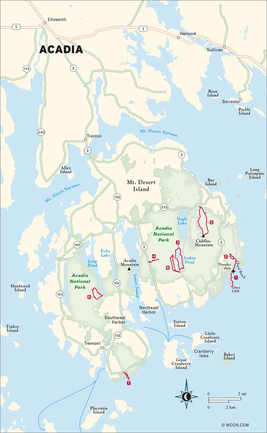
On a little slice of the Maine coast called Mount Desert Island, a secluded universe of exposed peaks, serene beaches, and unrivaled biodiversity welcomes millions each year. Acadia National Park is one of the oldest and most beloved parks in America. One look at a map illustrates why: The waterlocked wonder contains more than 120 miles of trails for every taste. You can wander around lagoons and fjords, search the woods for more than 40 species of mammalian wildlife, or scale cliffs steep enough to make you feel like a sponsored athlete. To top it off, the villages of Bar Harbor and Southwest Harbor are your ticket for freshly caught sustenance including lobsters, bluefish, and good old Maine steamers.
3 South Bubble and Jordan Pond
6 Perpendicular and Razorback Trails

ACADIA NATIONAL PARK, BAR HARBOR

This wildly popular hike along Acadia’s eastern shoreline is like walking through a series of postcards that showcase the rugged beauty of coastal Maine.
BEST: Spots for a swim
DISTANCE: 3.6 miles round-trip
DURATION: 1.5 hours
ELEVATION CHANGE: 92 feet
EFFORT: Easy
TRAIL: Dirt path, rocks
USERS: Hikers, leashed dogs
SEASON: April-November
FEES/PASSES: $30 park entrance fee per vehicle, May-October
MAPS: Acadia National Park website
CONTACT: Acadia National Park, 207/288-3338, www.nps.gov/acad. Hulls Cove Visitor Center is open from April 15 through October 31. Call the park to verify hours.
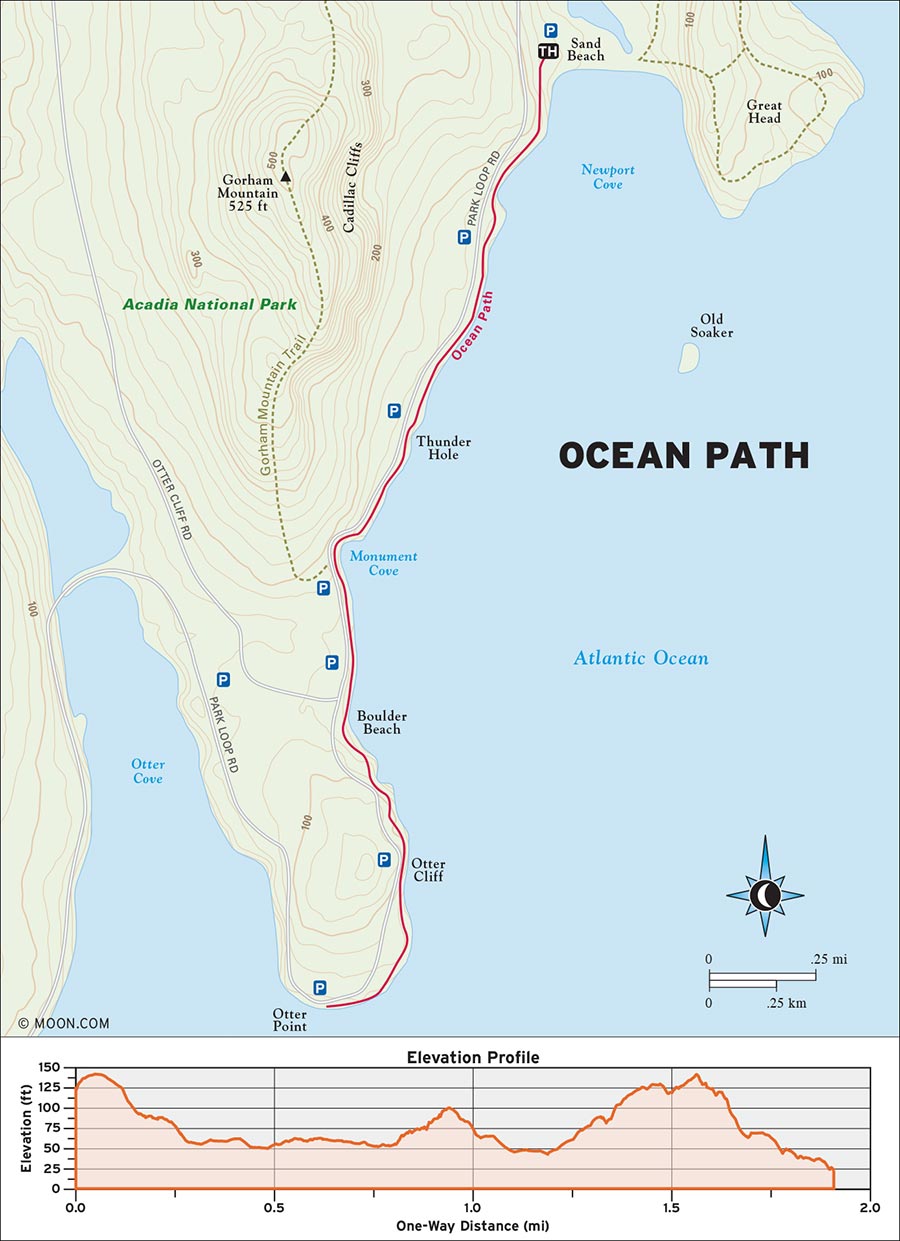
 MILE 0-0.7: Ocean Path Parking Lot to Thunder Hole
Begin the hike in the small parking lot directly above the larger Sand Beach parking area. At the southern end of the lot, find the wooden post labeled Ocean Path and pick up the wide gravel trail as it climbs a hillside and then emerges beside Park Loop Road. The trail ambles south along the road, passing a series of rocky beaches. At 0.4 mile, you’ll enter a corridor of balsam fir and spruce trees. The beaches transition into shelf-like cliffs, and several little spur trails on the left offer vistas of the cliffs and the ocean beyond.
At 0.7 mile, emerge from the woods to reach Thunder Hole—a tidal basin through which the incoming waves create a thunder-like booming sound. A metal walkway down to the hole offers a closer look, as well as a chance to get drenched by the waves as they explode against the rock walls of the basin.
 MILE 0.7-1.4: Thunder Hole to Otter Cliffs
From here, the trail begins to branch away from the road as it passes more shelf cliffs, on which you might see families picnicking or simply enjoying the view. At 1.2 miles, the trail enters a much thicker forest of hemlock-spruce and mossy boulders. The footing gets rootier and rockier henceforth, but the trail remains nearly level, even as it climbs higher above the ocean.
At 1.4 miles, the trees open up once again as the trail reaches Otter Cliffs—a destination for rock climbers, who can often be seen scaling the craggy rock faces here.
 MILE 1.4-3.6: Otter Cliffs to Ocean View Vista
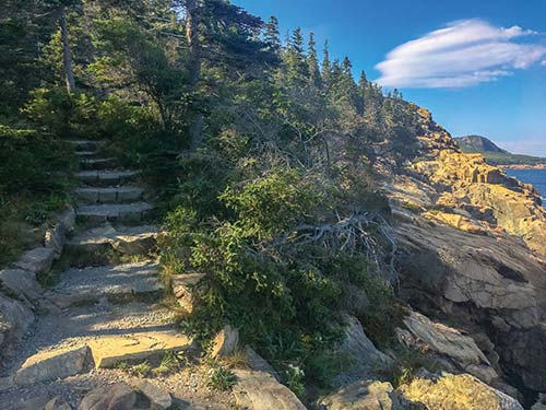
Climb a set of stone stairs to reach an observation walkway that hugs Park Loop Road, walk to the end of the walkway, and descend another staircase to return to the woods. At 1.6 miles, right after descending this staircase, take a moment to look behind you for an incredible view of the Beehive and Champlain Mountain framed by the sea and the sky. Continue as the trail curves southwest through a thick grove of ferns before it delivers you to a final vista that overlooks the ocean at 1.8 miles. Return the way you came.
From Bangor, drive southeast on US-1A E for 25 miles. After crossing the bridge onto Mount Desert Island, turn left at the fork onto ME-3 E. Continue driving along ME-3 E for about 10 miles into the town of Bar Harbor, and then drive straight onto Kebo Street. Take Kebo Street south until its terminus and then veer left onto Park Loop Road. Drive along this road to the Sand Beach entrance station and then continue south to the sign for Sand Beach parking, which will be on your left. The entrance to the larger lot comes first and the turnoff for the small lot (from which the Ocean Path begins) comes immediately after. If both lots are full, roadside parking on the right side is allowed.
GPS COORDINATES: 45°53'11.7"N 68°59'59.1"W, 45.886588, -68.999748
THE OCEAN PATH
ACADIA NATIONAL PARK, BAR HARBOR

The hike up Beehive isn’t for the faint of heart, but it offers pretty views and a glacial lake to anyone up for the challenge.
DISTANCE: 1.6 miles round-trip
DURATION: 1 hour
ELEVATION CHANGE: 505 feet
EFFORT: Moderate
TRAIL: Dirt path, rocks, iron rungs, wooden bog bridges
USERS: Hikers
SEASON: June-October
FEES/PASSES: $30 park entrance fee per vehicle, May-October
MAPS: Acadia National Park website
CONTACT: Acadia National Park, 207/288-3338, www.nps.gov/acad. Hulls Cove Visitor Center is open from April 15 through October 31. Call the park to verify hours.
The Beehive might be the most perfectly named peak in Acadia—not only is this handsome little mountain shaped like a hive, but a closer look at its exposed cliffs on a summer day reveals intrepid hikers scaling the mountain like little worker bees. It’s another Acadia hike with lots of iron ladder rungs and handrails to aid your perilous journey. If it’s wet, or if you have a fear of heights, skip this hike. The ledges and sheer drops make this hike scary for anyone, at any time of year—people have fallen and been injured and killed. Be sure to watch your footing and have both hands free for the duration of the hike.
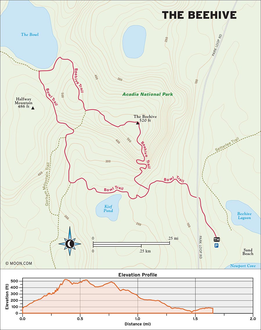
 MILE 0-0.2: Trailhead at Park Loop Road to Beehive Trail
Begin the hike at the wooden post along Park Loop Road that reads Beehive Trail. (The post is on the side of the road just north of the entrances to the Sand Beach parking lots.) Hike west up a stone path through the woods before reaching a clearing with a signpost for the Beehive Trail at 0.2 mile.
 MILE 0.2-0.3: Beehive Trail to Split Ledge and Metal Grate
Make a right turn onto the trail, which heads north and immediately begins climbing the Beehive by way of narrow stone stairs. Enjoy the wide ledges and early views here. Follow blue blazes on the trees and cliffs as the trail becomes a series of switchbacks and arrives as a section of split ledge that’s bridged with a metal grate at 0.3 mile. Crossing this narrow grate is one of the scarier parts of the hike.
 MILE 0.3-0.5: Split Ledge and Metal Grate to Beehive Summit
Continue past the grate and carefully make your way up the first round of iron rungs and handrails, noting the placement of your feet as you climb. The smooth rungs can sometimes be slippery due to being handled by lots of hikers who’ve applied sunscreen recently. Squeeze behind some balsam firs and watch your footing as the trail becomes a much higher and narrower ledge that overlooks Sand Beach. Take a minute to enjoy the vista and calm your nerves. Beyond this ledge, the trail ascends its most complex series of rungs. Scramble up this final series of ledges, and you’ll be standing atop The Beehive’s rocky summit at 0.5 mile.
 MILE 0.5-0.7: Beehive Summit to The Bowl
Once you’re ready for a soothing return journey, follow the blue blazes into a grove of balsams and down some rock stairs. At just under 0.6 mile, veer right onto the Bowl Trail and amble over a secondary summit before descending into the forest on a rocky dirt path. Listen for the lapping of water as you approach the shores of The Bowl at 0.7 mile, and enjoy the stillness of this little glacial lake as the trail continues along its eastern shoreline.
 MILE 0.7-1.1: The Bowl to Beehive Trail
After crossing a swampy area on some bog bridges, make a left at the Champlain Mountain Trail junction to stay on the Bowl Trail and descend a few gentle log stairs into boreal forest. At 0.9 mile, the trail intersects the Beehive Trail again; turn right onto Beehive and make your way down more log stairs, keeping left to stay on Beehive at the next two junctions for Gorham Mountain.
 MILE 1.1-1.6: Beehive Trail to Sand Beach
Enjoy a final view of the Beehive cliffs as the trees open up and the trail returns to the first Beehive Trail cutoff at 1.2 miles. Backtrack down the stone path to Park Loop Road to conclude the hike at 1.6 miles. For a cooldown, cross the road and descend the stairs to Sand Beach.
From Bangor, drive southeast on US-1A E for 25 miles. After crossing the bridge onto Mount Desert Island, turn left at the fork onto ME-3 E. Continue driving along ME-3 E for about 10 miles into the town of Bar Harbor, and then drive straight onto Kebo Street. Take Kebo Street south until its terminus and then veer left onto Park Loop Road. Drive along this road to the Sand Beach park entrance station, and then continue south briefly until you see the sign for Sand Beach parking on your left. The entrance to the larger lot comes first and the turnoff for a smaller lot comes immediately after. If both lots are full, roadside parking on the right side of the road is allowed.
GPS COORDINATES: 44°19'53.6"N 68°11'07.1"W, 44.331559, -68.185297
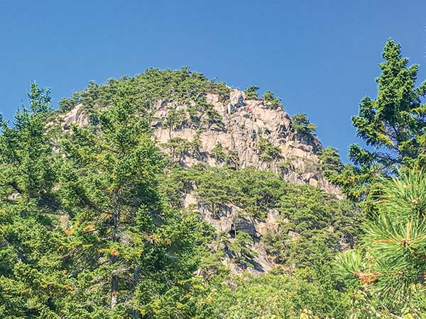
THE BEEHIVE’S EXPOSED SOUTH FACE
ACADIA NATIONAL PARK, BAR HARBOR

This fun hike along Jordan Pond visits the summit of South Bubble, offering vistas, rock climbing, and bog bridges along the way.
BEST: Fall hikes
DISTANCE: 3.6 miles round-trip
DURATION: 3 hours
ELEVATION CHANGE: 498 feet
EFFORT: Moderate
TRAIL: Dirt path, rocks, wooden bog bridges, water crossings on stones
USERS: Hikers
SEASON: June-October
FEES/PASSES: $30 park entrance fee per vehicle, May-October
MAPS: Acadia National Park website
CONTACT: Acadia National Park, 207/288-3338, www.nps.gov/acad. Hulls Cove Visitor Center is open from April 15 through October 31. Call the park to verify hours.
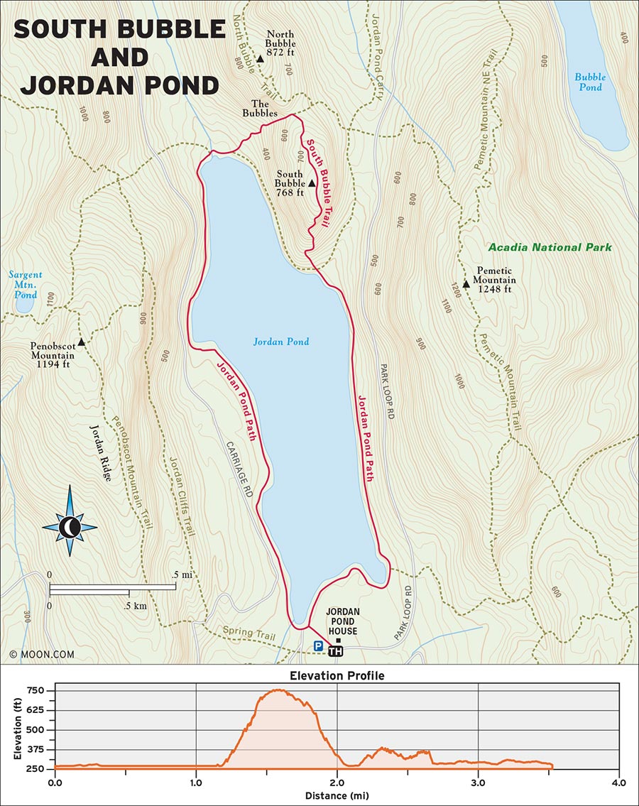
 MILE 0-0.3: Jordan Pond House to Carriage Road
Begin the hike at the end of the observation lawn at Jordan Pond House, on the southern shore of the pond. Looking straight out to the pond and the Bubbles, you’ll be standing on a groomed gravel path; this is the Jordan Pond Trail. Head right and stroll through some wildflowers and into the cedar and spruce woods on the pond’s eastern shore. Continue north along the shoreline on this gentle section, passing several boat launches and some little rocky beaches. As you circle a larger cove, the forest transitions to hemlocks and passes a cutoff for the Carriage Road at 0.3 mile.
 MILE 0.3-1.3: Carriage Road to Bubbles Trail
Keep left here and check out the views of the cliffs on neighboring Penobscot Mountain on the western side of the pond. Follow signs for Bubble Rock as the smooth path veers close to the water—close enough to spot trout swimming beneath the surface on a sunny day! One mile in, you’ll cross a wooden footbridge over a creek before approaching the foot of South Bubble. Cross a second bridge to reach a junction for the Bubbles Trail at 1.3 miles; pick up the trail and warm up your quads with a moderately graded ascent up rock stairs and through the woods. Blue blazes mark the path.
 MILE 1.3-1.5: Bubbles Trail to South Bubble
As the stairs become rougher and steeper, the trail emerges from the trees and slabs dramatically up the southern face of the mountain. One trickier section requires passing through a tight crevice of rock. A few iron rungs are placed here and there to help hikers bypass the steeper parts of the climb, which soon levels off and reaches the globular rocky summit of South Bubble at 1.5 miles. There are views of Jordan Pond to the south and Pemetic Mountain to the east.
 MILE 1.5-1.6: South Bubble to Summit Rock
Before continuing onward, scramble down the rock slopes on the eastern edge of the summit to find the mountain’s famous glacial erratic—a house-sized rock that’s precariously placed on the edge of a cliff!
 MILE 1.6-2.1: Summit Rock to Bubbles Divide Trail
Hike north past the summit proper and dip back into the woods and down some log stairs to reach the wooded col (gap) between the two Bubbles. Turn left at the Bubbles Divide junction at 1.8 miles to take Bubbles Divide Trail and descend a steep and winding rock staircase that becomes more like a boulder field as you approach the waters of Jordan Pond again.
 MILE 2.1-2.3: Bubbles Divide Trail to Jordan Pond Trail
At 2.1 miles, make a right to link back up with the Jordan Pond Trail. Pass a large pebbly beach and cross a larger wooden footbridge to reach the Deer Brook junction at 2.2 miles. Veer left to stay on Jordan Pond and return along the pond’s more densely forested western shores.
 MILE 2.3-3.6: Jordan Pond Trail to Jordan Pond House
The woods on this side of the pond are a lot rockier and darker. The trail stays near the water but makes use of the rougher landscape by rock-hopping across watery sections and weaving between some massive boulders. The grand finale—a long, meandering boardwalk of wooden bog bridges—begins at roughly 2.7 miles. These bridges, many of which are new, traverse a mossy bog-like area of forest. Some of them are a couple of feet above the ground or water, so be sure to watch your balance. After the last bridge, the trail reaches the Carriage Road at 3.6 miles. Merge onto the road and take an immediate left onto the Jordan Pond Path, which delivers you back to the Pond House after just a few yards.
From Bangor, drive southeast on US-1A E for 25 miles. After crossing the bridge onto Mount Desert Island, turn right at the fork and continue south along ME-102 S for about 4 miles before swinging left onto ME-3 W. Drive southwest for another 5 miles, make a left turn to stay on ME-3 W, and then take a left at the Stanley Brook entrance for Acadia. Take this road to its terminus, make a slight left onto Park Loop Road, and drive north until you see the Jordan Pond House entrance on your left. If the lot here is full (which it usually is), continue north past the Pond House and turn left to access the overflow parking areas.
GPS COORDINATES: 44°19'22.5"N 68°15'13.4"W, 44.322917, -68.253715
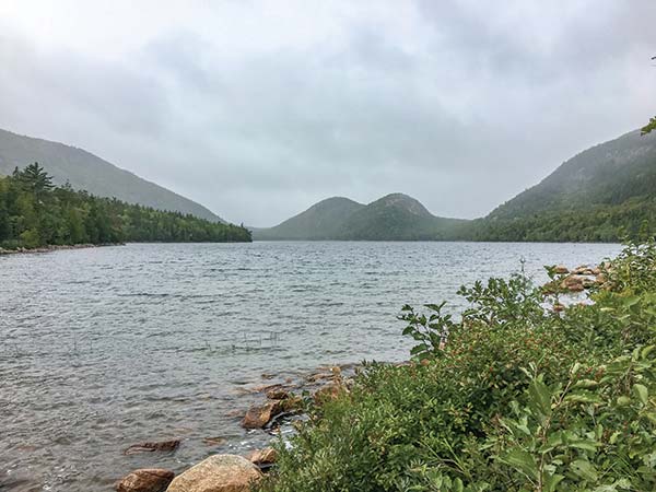
THE BULBOUS PROFILE OF THE BUBBLES AT THE NORTH END OF JORDAN POND
ACADIA NATIONAL PARK, BAR HARBOR

This quiet and meditative hike to Acadia’s prettiest waterfall is a chance to stroll along the famous carriage roads that wind through the island’s woods.
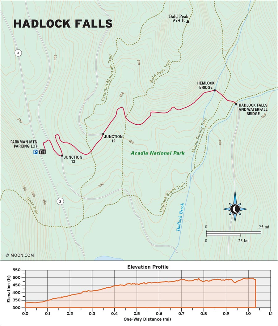
DISTANCE: 2 miles round-trip
DURATION: 1 hour
ELEVATION CHANGE: 146 feet
EFFORT: Easy
TRAIL: Gravel path, optional rock stairs
USERS: Hikers, cyclists, horseback riders
SEASON: May-October
FEES/PASSES: $30 park entrance fee per vehicle, May-October
MAPS: Acadia National Park website
CONTACT: Acadia National Park, 207/288-3338, www.nps.gov/acad. Hulls Cove Visitor Center is open from April 15 through October 31. Call the park to verify hours.
The modest yet beautiful 40-foot-tall Hadlock Falls is among the park’s lesser-known attractions (most tourists are focused on the mountain and coastline). If you’re on foot, the only way to reach it is to take a walk along Acadia’s carriage roads as they meander along the southern flanks of Parkman Mountain and Sargent Mountain. The falls are most impressive during the late spring and early summer, when the flow is more dramatic.
 MILE 0-0.4: Parkman Mountain Parking Lot to Junction 12
Begin the hike at the north side of the Parkman Mountain parking lot by the large wooden information kiosk for the carriage road. Walk northeast past the sign and make an immediate right turn onto the carriage road. Briefly take the road south through a mixed forest of spruce and birch before turning left at the 13 junction. (Look for a little sign bearing the number 13 on a tree—all the carriage road junctions are marked numerically like this.)
The road sharply veers northwest and climbs a duet of switchbacks through mossy, boulder-strewn woods. As you pass several cliff faces, note how the baby cedar trees explode out of the rifts in the cliff. As the sound of auto traffic fades away, the road curves northeast and reaches Junction 12 at 0.4 mile.
 MILE 0.4-0.9: Junction 12 to Arched Stone Bridge
Turn right here and continue hiking along the road as it meanders through a denser corridor of hemlock and balsams. The nearby ripple of a stream offers a teaser of things to come, and the cliffs start to tower over the road in places. Pass by the Bald Mountain Trail cutoff at 0.6 mile, then enjoy a few glimpses of Penobscot Mountain ahead. Suddenly cedar and balsam fir become the dominant trees here. Also take a look along the side of the trail for wildflowers such as asters and goldenrods, especially in late summer or early fall. Continue hiking east for 0.3 mile.
 MILE 0.9-2.0: Arched Stone Bridge to Hadlock Falls
At 0.9 mile, the road crosses an arched stone bridge over a creek. Hike past the Maple Springs Trail before arriving at a second arched bridge overlooking Hadlock Falls. The bridge is outfitted with a little cleft from which visitors can view the falls, but a set of rock stairs on the left side of the road allows hikers to descend closer to the cascade—which is complemented by a little observation terrace that would be a hell of a place to propose to someone. The rocks at the foot of the falls can get very slick from the moss and water, but as long as you watch your footing, it doesn’t take much effort to scramble close enough to feel the cooling mist of Hadlock Falls—the perfect finale to a heavenly hike. Return the way you came.
From Bangor, drive southeast on US-1A E for 25 miles. After crossing the bridge onto Mount Desert Island, turn right at the fork and continue south along ME-102 S for about 4 miles before swinging left onto ME-3 W. Drive southwest for another 4 miles and then take a sharp left at the sign for the Parkman Mountain parking lot.
GPS COORDINATES: 44°19'45.5"N 68°17'34.8"W, 44.329301, -68.292985
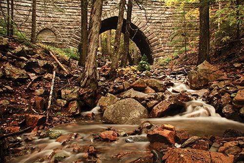
STONE BRIDGE ALONG ACADIA'S CARRIAGE ROADS
ACADIA NATIONAL PARK, BAR HARBOR

This hidden gem of a mountain hike reaches the highest summit in Acadia by negotiating the rocky recesses of an atmospheric gorge complete with waterfalls.
BEST: Spring hikes, brew hikes
DISTANCE: 4.6 miles round-trip
DURATION: 2.5 hours
ELEVATION CHANGE: 1,240 feet
EFFORT: Strenuous
TRAIL: Dirt path, rocks, water crossings by rocks, wooden bog bridges
USERS: Hikers
SEASON: June-October
FEES/PASSES: $30 park entrance fee per vehicle, May-October
MAPS: Acadia National Park website
CONTACT: Acadia National Park, 207/288-3338, www.nps.gov/acad. Hulls Cove Visitor Center is open from April 15 through October 31. Call the park to verify hours.

No trip to Acadia is complete without the superlative climb up Cadillac Mountain, the tallest point on the island at 1,529 feet above sea level. Most visitors take the well-worn North Ridge Trail to the summit, but a better option is to take Gorge Path—a lesser-known, more sublime experience—to the top and then descend via North Ridge.
 MILE 0-0.4: Gorge Path Parking Lot to Hemlock Trail Junction
Begin the hike at the Gorge Path parking lot on the side of Park Loop Road. Walk toward the east side of the stone bridge, where a wooden trail post reads “Gorge Path.” Descend some stone stairs to the bottom of the bridge, cross the stream, ascend another set of stairs, and then turn left onto the Gorge Path. The trail begins as a dirt path that burrows south through a thick and dark hemlock forest. Blue blazes mark the way. After passing into a sunnier stretch of white birch forest, the trail crosses creek beds and wooden bog bridges over muddy areas before reaching the Hemlock Trail junction at 0.4 mile.
 MILE 0.4-1.6: Hemlock Trail Junction to A. Murray Young Path
Keep right to stay on Gorge. Cross another pebbly creek bed as the trail becomes a smooth highway of well-placed stones. The grade of the surrounding forest steepens on both sides of the trail. Around 0.6 mile, the severe rock cliffs of the gorge itself begin to appear, as well as a pretty, silvery cascade. Continue hiking south along the rock pathway past several smaller cascades as the trail gradually steepens. One mile in, you’ll pass a jumble of mossy boulders just before the trail makes a sharp, lung-busting climb out of the gorge with the help of some winding rock staircases. The trail gets sunnier, with some views of Cadillac Mountain’s upper slopes through the trees on the right. The trail grade becomes gentler as it arrives at the Dorr Mountain Trail junction at 1.3 miles. Turn right to continue on the Gorge Path as it curves toward the summit of Cadillac Mountain, and take another right to stay on Gorge at the junction with the A. Murray Young Path.
 MILE 1.6-1.8: A. Murray Young Path to Cadillac Mountain Summit
The trail emerges from the woods by climbing a series of boulders and ledges, revealing the first primo view of Bar Harbor as well as a stunning perspective of the rocky western face of Dorr Mountain. Look for blue blazes on the rocks as you tunnel through some spruce and pine trees before cresting a ridge from which the summit of Cadillac—dotted with the silhouettes of people and vehicles—comes into focus. Follow cairns along the exposed upper reaches of the mountain for another 0.2 mile, cross the paved summit observation footpath, and bound up some modest rocks to the summit proper of Cadillac Mountain at 1.8 miles. Most summit visitors tend to stick to the footpath, so you should have the true summit all to yourself for views, pictures, and meditation.
 MILE 1.8-3.9: Cadillac Mountain Summit to North Ridge Trailhead
To descend the mountain by way of the popular North Ridge Trail, walk north across the summit parking lot and find the trail sign on a wooden post. The trail descends gently across a long and exposed ridgeline that offers an incredible panorama of the north side of Mount Desert Island and, on a clear day, the verdant landscapes of mainland Maine. Most of the North Ridge Trail is pure rock, which can be slippery when wet. After traversing the exposed ridge for nearly 1 mile, the trail dips into the woods on rock stairs and passes several sunlit clearings before making a final exciting descent down a series of sloped rock faces to reach the North Ridge trailhead and parking area at 3.9 miles.
 MILE 3.9-4.6: North Ridge Trailhead to Gorge Path Parking Area
Take a right here and walk east along the Park Loop Road for another 0.7 mile until you reach the Gorge Path parking area at 4.6 miles.
From Bangor, drive southeast on US-1A E for 25 miles. After crossing the bridge onto Mount Desert Island, turn left at the fork onto ME-3 E. Continue driving along ME-3 E for about 9 miles and then turn right onto Paradise Hill Road. Follow this road for 3 miles as it climbs into the hills near Bar Harbor. As the road ends and merges with Park Loop Road, pull a sharp left and then a right onto Park Loop Road. Drive north and then southeast along Park Loop Road for roughly 1 mile until you see the sign for Gorge Path on your right.
GPS COORDINATES: 44°22'21.6"N 68°13'19.0"W, 44.372663, -68.221936

CADILLAC MOUNTAIN
ACADIA NATIONAL PARK, SOUTHWEST HARBOR

Climb hundreds of exquisitely carved stone stairs up the side of Mansell Mountain, then scramble down an exposed rock formation with nice views of Mount Desert Island’s southwest woods.
BEST: New England oddities
DISTANCE: 2.6 miles round-trip
DURATION: 2.5 hours
ELEVATION CHANGE: 868 feet
EFFORT: Moderate
TRAIL: Dirt path, rocks, iron rungs, wooden bog bridges
USERS: Hikers, leashed dogs
SEASON: June-October
FEES/PASSES: $30 park entrance fee per vehicle, May-October
MAPS: Acadia National Park website
CONTACT: Acadia National Park, 207/288-3338, www.nps.gov/acad. Hulls Cove Visitor Center is open from April 15 through October 31. Call the park to verify hours.
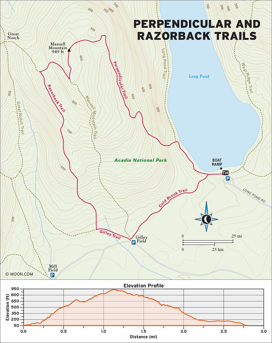
 MILE 0-0.2: Spring Trail to Perpendicular Trail
Begin the hike in the parking lot beside the southern end of Long Pond. Walk west toward the pumphouse and look for a wooden post for Long Pond Trail. A gravel path along the shore of the pond takes you into the forest. Keep right at the first junction and continue along the pond until you reach the turnoff for Perpendicular Trail at 0.2 mile; turn left and start climbing a series of low, gentle rock stairs.
 MILE 0.2-0.3: Perpendicular Trail to Long Pond View
As you climb through a breezy grove of spruce woods, following blue blazes on the tree trunks, the stairs become switchbacks and then emerge from the trees into an expansive rockslide at around 0.3 mile. Check out the view of Long Pond below, then continue the ascent. From here, the staircases become steeper, narrower, and more winding.
 MILE 0.3-0.9: Long Pond View to Mansell Mountain Summit
As the stairs reenter the woods, climb a small set of iron rungs installed into a rock slab that separates two sections of stairs. Cedar trees overtake the spruce as the stairs get rougher and bypass some small boulders. At 0.5 mile, enter a mossier patch of forest and enjoy a brief break from the stairs as the trail hobbles along a sheer cliff face that’s often trickling with water runoff. The trail becomes a level wooded ledge for a few hundred yards before transitioning back to stairs. Continue your climb and watch your footing as the trail becomes rougher and ascends several large rock formations flanked by birch trees. After passing a small ravine full of blowdowns, you’ll climb a more open wooded slope from which you can glimpse the mountains and forest to the east.
At 0.9 mile, turn left at the junction and climb a few wet crags to reach the Mansell Mountain summit at 1 mile. Pause here, then press on—the greatest views are yet to come.
 MILE 0.9-1.5: Mansell Mountain Summit to Razorback Trail
Continue past the summit cairn and head into the woods, cross some bog bridges, and turn right at the junction at 1.2 miles. The trail descends a steep, eroded, and rooty section of trail. From the bottom of this doozy, ascend some rock slabs to reach the junction with the Razorback Trail at 1.5 miles.
 MILE 1.5-2.1: Razorback Trail to Gilley Trail
Turn left onto Razorback and hike (or scramble) your way down a series of sawtooth rock faces that can be quite slippery when wet. The outlooks along this section have photo-worthy views of Mount Desert Island’s southwest woods.
Keep scrambling along rock faces for another quarter mile before heading back into the woods, where the trail makes a moderately graded descent down a combination of rock stairs and rooty path. At 2 miles, turn left at the Gilley Trail junction and follow Gilley to the roundabout at 2.1 miles.
 MILE 2.1-2.6: Gilley Trail to Long Pond Trail
Walk straight across the roundabout and pick up the Cold Brook Trail, which cruises through the woods past young balsams at a near-level grade. Cross a wooden footbridge over a creek to rejoin the Long Pond Trail at 2.5 miles. Turn right and backtrack to the parking lot to complete the loop at 2.6 miles.
From Bangor, drive southeast on US-1A E for 25 miles. After crossing the bridge onto Mount Desert Island, turn right at the fork onto ME-102 S. Continue south along this road for 10 miles and then swing right onto Seal Cove Road. After roughly half a mile, turn right onto Long Pond Road and follow it to its terminus at the southern shore of Long Pond, where you’ll see the visitors parking lot. If the lot is full, park alongside the road near the pond.
GPS COORDINATES: 44°18'00.8"N 68°21'01.0"W, 44.300208, -68.350266
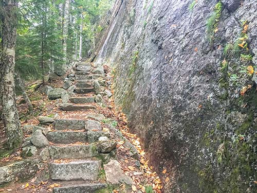
THE WINDING STAIRS OF THE PERPENDICULAR TRAIL
ACADIA NATIONAL PARK, SOUTHWEST HARBOR

This secluded ocean hike takes visitors through an otherworldly landscape of pink granite, mixed forests, and that classic Maine fog that regularly envelops the coast.
DISTANCE: 1.4 miles round-trip
DURATION: 45 minutes
ELEVATION CHANGE: 81 feet
EFFORT: Easy
TRAIL: Dirt path, rocks, wooden bog bridges
USERS: Hikers
SEASON: May-October
FEES/PASSES: $30 park entrance fee per vehicle, May-October
MAPS: Acadia National Park website
CONTACT: Acadia National Park, 207/288-3338, www.nps.gov/acad. Hulls Cove Visitor Center is open from April 15 through October 31. Call the park to verify hours.
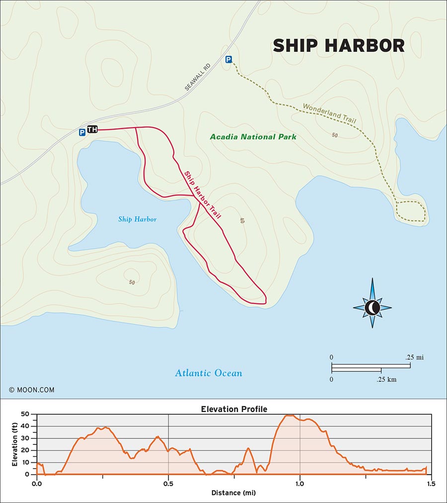
 MILE 0-0.6: Ship Harbor Parking Lot to Mount Desert Island
Begin the hike in the Ship Harbor parking lot. Pick up the gravel path and briefly descend south into a meadow before veering slightly east and passing a trail information kiosk for Ship Harbor. Continue southeast through a tunnel of ferns, wildflowers, and mixed trees before the forest widens into rich green wonderland of massive spruce trees. Keep an eye out for deer, which are active here, and hike southeast to the fork at roughly 0.1 mile. It’s all the same trail, but for the most compelling sequence of sights, take a left here.
As you continue southeast through the woods, the trail passes through verdant blankets of moss. Reach another fork at 0.4 mile, and this time, swing right. Listen for the gentle lapping of the ocean as the trail partially emerges from the woods and meanders along Ship Harbor itself—a shallow, pool-shaped inlet. On your right, you’ll notice a few sets of log stairs that offer hikers the chance to descend to a stony beach at the water’s edge. The trail becomes rockier and climbs some log stairs to pass into a new forest zone of abundant and very skinny hemlocks. Cross some wooden bog bridges, minding your footing during wet weather, and prepare for another transition as the trail suddenly leaves the woods behind at 0.6 mile and arrives at the southern edge of Mount Desert Island—a gorgeous landscape of pink granite rocks and gentle waves.
 MILE 0.6-1.0: Mount Desert Island to Rock Stairs
From here, hikers can choose to scramble around the rocks or stick to the path, which is now flanked by spruce trees small enough to allow for an unobstructed view of the coast. As the trail veers left into some bushes and crosses a few more bog bridges, the pattering of the waves becomes quieter and the trail reenters the forest at 0.7 mile. Continue walking northwest through the forest over more bog bridges and down some spacious rock stairs to arrive at a familiar-looking fork at 1 mile. Turn left.
 MILE 1.0-1.4: Rock Stairs to Ship Harbor Trailhead
The concluding lap of the hike—which resembles a figure-eight—returns to the inlet, ambling along the water from a higher position. The hemlocks here are even more majestic than the ones in the woods. A final winding descent delivers you to the first fork at 1.3 miles. Take a left turn here and backtrack northwest to the trailhead to complete the hike at 1.4 miles.
From Bangor, drive southeast on US-1A E for 25 miles. After crossing the bridge onto Mount Desert Island, turn right at the fork onto ME-102 S. Continue south along this road through the town of Southwest Harbor for 13 miles and then take a slight left onto ME-102A N. Drive south and then east along this road for another 2 miles; shortly after, the parking lot and trailhead for Ship Harbor will be on your right. If the parking lot is full, you can park along the side of the road.
GPS COORDINATES: 44°13'56.0"N 68°19'22.4"W, 44.232217, -68.322900
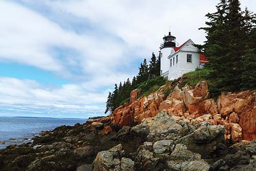
BASS HARBOR HEAD LIGHTHOUSE
ACADIA NATIONAL PARK, BAR HARBOR

Climb one of Acadia’s most popular mountains via a series of dramatic cliff faces for awe-inspiring views of the coast.
DISTANCE: 3.3 miles round-trip
DURATION: 2 hours
ELEVATION CHANGE: 1,027 feet
EFFORT: Strenuous
TRAIL: Dirt path, rocks, iron rungs, wooden bog bridges
USERS: Hikers
SEASON: June-October
FEES/PASSES: $30 park entrance fee per vehicle, May-October
MAPS: Acadia National Park website
CONTACT: Acadia National Park, 207/288-3338, www.nps.gov/acad. Hulls Cove Visitor Center is open from April 15 through October 31. Call the park to verify hours.
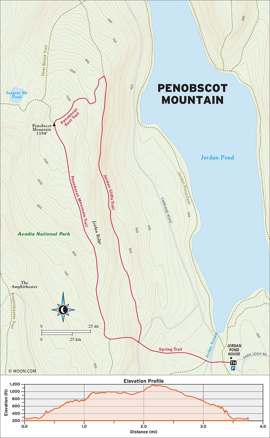
The most unforgettable way up Penobscot is the Jordan Cliffs Trail—a wildly scenic climb across the rock walls that form the eastern flank of the peak. The trail is not especially steep, but its iron ladders and narrow ledges can make sections of this hike feel like a training run for American Ninja Warrior. If the weather is wet, take a different trail to the top. The trail is also occasionally closed if peregrine falcons have been spotted in the area (there is a nesting zone along the trail).
 MILE 0-0.3: Jordan Pond House to Jordan Cliffs Trail
Begin the hike by the restroom entrance outside the Jordan Pond House. Veer left at the wooden trail post to pick up a gravel path that descends into the forest. Cross the carriage road and continue east over a wooden bridge that crosses a creek. Amble through the woods briefly and then turn right at the junction for Jordan Cliffs Trail, which follows blue blazes through a mossier stretch of forest.
The trail swings north and climbs some gentle stone stairs to reach another junction at roughly 0.3 mile. Keep right here as the trail crosses the carriage road once more and continues into the forest on the opposite side.
 MILE 0.3-1.0: Carriage Road to Sheer Cliff Face
Climbing gradually through airier spruce-and-fir woods, the dirt trail quickly transitions to sloped slabs of rock with a notable peach hue. A few fleeting views of Penobscot’s summit appear through the trees on the left. At 0.7 mile, the trail levels out and continues north. Suddenly, the woods on your right will open to reveal the expanse of Jordan Pond several hundred feet below. The footing gets rockier, and the trail climbs higher with the help of steep rock stairs. One mile in, the trail traverses the first sheer cliff face and becomes much skinnier—watch your step here.
 MILE 1.0-1.6: Sheer Cliff Face to Penobscot East Trail
After dipping in and out of the woods, the trail arrives at the first obstacle at 1.1 miles: a large boulder that hikers must climb over with the help of a single iron rung and a bar installed in the rock. (Consider this your last chance to turn back.) The trail continues north but becomes much rougher, with lots of exposed tree roots. At 1.3 miles, you’ll cross a long balance beam-like wooden bridge with handrails. Descend the stairs at the end of the bridge and prepare to tread carefully—the trail traverses a much longer stretch of exposed cliff here with the help of iron rungs in the rock, including one vertical rung climb of at least 15 feet that requires the use of handholds in the surrounding rock. Be sure that your boots have a good grip on each rung before stepping onto the next rung.
At the top of this scary stretch, the trail swerves into the woods and climbs a gentler stony path to the junction with the Penobscot East Trail at 1.6 miles.
 MILE 1.6-1.9: Penobscot East Trail to Penobscot Mountain Summit
Swing left onto Penobscot East Trail and hoist your way up some boulders and rock ledges onto the upper heights of Penobscot. The trail meanders across the alpine landscape, following blue-blazed cairns, before climbing to a final height of land and reaching the Penobscot Mountain summit signpost at 1.9 miles.
 MILE 1.9-2.8: Penobscot Mountain Summit to Spring Trail
Enjoy the views while beginning your return journey down the Penobscot Mountain Trail from the summit post. The initial descent is a dreamy stroll down the mountain’s broad summit, with the south coast of Mount Desert Island serving as an epic backdrop. Continue south for 0.9 mile as the crops of young spruce trees segue into full-on forest. At 2.8 miles, take a left at the junction onto Spring Trail.
 MILE 2.8-3.3: Spring Trail to Jordan Cliffs Trail and Jordan Pond House
The descent becomes very steep after this point, with rock steps, some slabs, and even a wooden boardwalk that hugs a series of sheer cliff faces. It’s hair-raising, but short-lived. The trail reaches the carriage road again at 3 miles. Cross to the other side and make your way down some rugged rock stairs before reaching the Jordan Cliffs Trail junction at 3.1 miles. Turn right, backtrack to the Jordan Pond House, and complete your hike at a hearty 3.3 miles.
From Bangor, drive southeast on US-1A E for 25 miles. After crossing the bridge onto Mount Desert Island, turn right at the fork and continue south along ME-102 S for about 4 miles before swinging left onto ME-3 W. Drive southwest for another 5 miles, make a left turn to stay on ME-3 W, and then take another left turn at the Stanley Brook entrance for Acadia. Take this road to its terminus, make a slight left onto Park Loop Road, and drive north until you see the Jordan Pond House entrance on your left. If the lot here is full (which it usually is), continue north past the Pond House and turn left to access the overflow parking areas.
GPS COORDINATES: 44°19'13.5"N 68°15'15.1"W, 44.320428, -68.254180
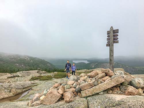
THE SUMMIT MARKER OF PENOBSCOT MOUNTAIN
| NEARBY CAMPGROUNDS | ||||
|---|---|---|---|---|
| NAME | LOCATION | FACILITIES | SEASON | FEE |
| Hadley’s Point Campground | 33 Hadley Point Rd., Bar Harbor, ME 04609 | Tent sites, RV sites, cabins, toilets, showers, potable water, laundry, swimming pool, camp store, Wi-Fi | late June through mid-October | $29-90 |
| 207/288-4808, www.hadleyspoint.com | ||||
| Bar Harbor Campground | 409 ME-3, Bar Harbor, ME 04609 | Tent sites, RV sites, toilets, showers, potable water, laundry, swimming pool, camp store, Wi-Fi | late May through mid-October | $34-46 |
| 207/288-5185, www.thebarharborcampground.com | ||||
| Blackwoods Campground | 155 Blackwoods Dr., Otter Creek, ME 04660 | Tent sites, RV sites, toilets, potable water | May through mid-October | $30-60 |
| 207/288-3274, www.recreation.gov | ||||
| Somes Sound View Campground | 5 Spinnaker Way, Mt Desert, ME 04660 | Tent sites, cabin tents, RV sites, cabins, toilets, showers, potable water, swimming pool, camp store, Wi-Fi | late May through mid-October | $30-90 |
| 207/244-3890, www.ssvc.info | ||||
| Bar Harbor/Oceanside KOA Campground | 136 County Rd., Bar Harbor, ME 04609 | Tent sites, RV sites, cabins, toilets, showers, potable water, laundry, camp store, Wi-Fi | mid-May through mid-October | $45-221 |
| 207/288-3520, www.koa.com | ||||
| Smuggler’s Den Campground | 20 Main St., Southwest Harbor, ME 04679 | Tent sites, RV sites, cabins, toilets, showers, potable water, laundry, swimming pool, camp store, Wi-Fi | late May through mid-October | $25-175 |
| 207/244-3944, www.smugglersdencampground.com | ||||
| Quietside Campground & Cabins | 397 Tremont Rd., Bernard, ME 04612 | Tent sites, RV sites, cabins, toilets, showers, potable water, laundry, camp store, Wi-Fi | mid-June through mid-October | $20-75 |
| 207/244-0566, www.quietsidecampground.com | ||||
| Bass Harbor Campground | 342 Harbor Dr., Bass Harbor, ME 04653 | Tent sites, RV sites, cabins, yurts, toilets, showers, potable water, laundry, swimming pool, camp store; Wi-Fi | May through October | $24-172 |
| 207/244-5857, www.bassharbor.com | ||||
| Seawall Campground | 668 Seawall Rd., Southwest Harbor, ME 04679 | Tent sites, RV sites, toilets, potable water | mid-May through mid-October | $22-60 |
| 207/244-3600, www.recreation.gov | ||||
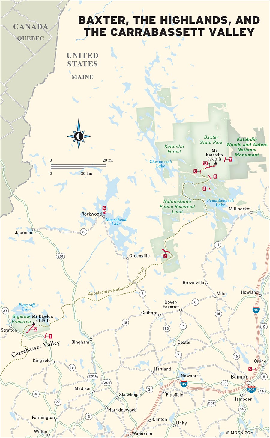
Northern Maine is a land of superlatives. The tallest mountain, biggest lake, and longest river in the state are all here. The region contains thousands of miles of trails, all of which are surrounded by acre after acre of evergreen frontier. To amble through Maine’s northern forests is to experience the Pine Tree State at its most rugged and majestic. For hikers who make the considerable journey here, three wild and wooded wonderlands await: Baxter State Park, the Maine Highlands, and the Carrabassett Valley. Each contains relics of Maine’s unique blend of logging and geological history—from old sawmills to older caves, cascades, and remote peaks that seem to poke the sky.
6 Little and Big Niagara Falls
CARRABASSETT VALLEY

Hike through dense and mossy woods to one of northern Maine’s more secluded cascades.
DISTANCE: 4.4 miles round-trip
DURATION: 2 hours
ELEVATION CHANGE: 268 feet
EFFORT: Easy
TRAIL: Dirt path, wooden bridges, water crossings on stones
USERS: Hikers, leashed dogs
SEASON: June-October
FEES/PASSES: None
MAPS: Maine Huts & Trails website
CONTACT: Maine Huts & Trails, 877/634-8824, www.mainehuts.org
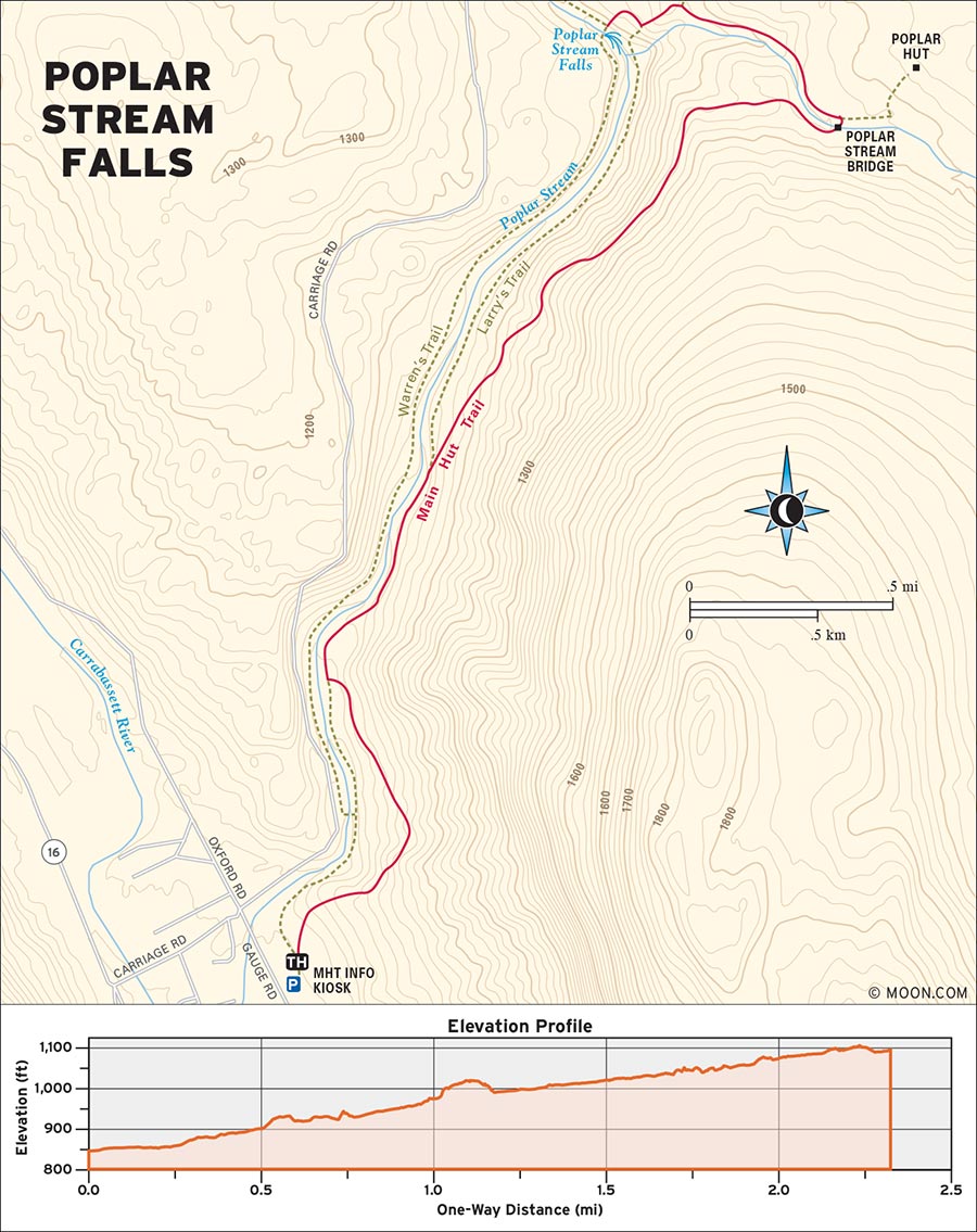
 MILE 0-0.1: Maine Huts & Trails Information Kiosk to Cutoff Trail
Begin the hike by the Maine Huts & Trails information kiosk in the parking lot just off Gauge Road. Pick up the grassy MHT Trail and follow it north for a brief 0.1 mile before turning left at the first junction onto the Cutoff Trail.
 MILE 0.1-0.5: Cutoff Trail to MHT Trail
Pick your way over some rocks as the blue-blazed trail climbs a hillside into thick, dark spruce forest. The trail follows Poplar Stream, getting steeper in a few places, before merging with the MHT Trail again at a junction at 0.5 mile. Turn left onto the MHT.
 MILE 0.5-2.0: MHT Trail to Poplar Stream Bridge
The MHT Trail continues north, rolling up and down over a brief knoll. The rockier, wider pathway almost feels like a dirt road. At 0.7 mile, turn right at the junction and climb a larger hillside as the trail crosses several small tributaries on wooden bridges. As you pass through a leafier stretch of woods, look for blue diamond markers on the trees bearing the Maine Huts & Trails brand and listen for woodpeckers and other birds. Swing left at the fork at 1.1 miles. From here, the trail enters a shadier patch of hemlock forest and becomes much narrower, following the gentle roar of Poplar Stream along a densely wooded hillside where the battle cry of the red squirrel is as constant as the sound of the water. Cruise along the path through some groves of ferns and make your way over some old bog bridges. Watch your step on exposed tree roots as the trail begins to descend at a moderate grade, arriving at a sturdy wooden footbridge over Poplar Stream at 2 miles.
 MILE 2.0-4.4: Poplar Stream Bridge Poplar Stream Falls and Poplar Hut
After crossing the bridge, you’ll hear the sound of crashing water echoing through the forest on your right. Continue north along the path until you reach a steep series of stone stairs; turn right here to stay on level ground, skipping the stairs, and continue a few more yards. At 2.2 miles, you’ll reach Poplar Stream Falls, a roaring chute of water that tumbles 50 feet into a stunningly pretty pool. The deep, reflective pool is cold but swimmable in the summer. Hikers interested in checking out nearby Poplar Hut can backtrack to the stone stairs and head up them to the junction for the hut. The hut offers comfy overnight lodging and locally sourced meals by reservation, and day hikers can purchase lunch here from 11:30am to 1:30pm on Saturday and Sunday during the full-service season (June 21-September 1). Otherwise, return the way you came.
From Portland, it’s about 2.5 hours to the trailhead. Take I-295 N and I-95 N to ME-3 and ME-27 N until it intersects with US-2 W. Turn left onto US-2 W and continue to West Farmington, where you’ll turn right onto ME-27 N once again. Drive north to Carrabassett Valley, turn right onto Carriage Road, and then take the first left to reach the Carrabassett Valley Town Office parking lot. (This is where you’ll leave your car.) To reach the trailhead, walk back to Carriage Road, turn left, and continue walking northeast along the road to Gauge Road. Make a right onto Gauge Road, cross a wooden footbridge over Poplar Stream, and take the first left to arrive at the Poplar Stream Falls trailhead.
GPS COORDINATES: 45°04'44.4"N 70°12'27.7"W, 45.078993, -70.207693
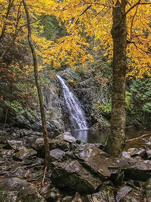
THE ROARING TUMULT OF POPLAR STREAM FALLS
BIGELOW PRESERVE, STRATTON

Venture deep into the woods to visit a pair of peaks with incredible views of one of Maine’s tallest mountains.
DISTANCE: 10 miles round-trip
DURATION: 6.5 hours
ELEVATION CHANGE: 2,615 feet
EFFORT: Strenuous
TRAIL: Dirt path, rocks, wooden bridges, water crossings on stones
USERS: Hikers, leashed dogs
SEASON: June-September
FEES/PASSES: None
MAPS: Maine Department of Agriculture, Conservation, and Forestry website
CONTACT: Maine Bureau of Parks and Lands, 207/778-8231, www.maine.gov/bigelowpreserve
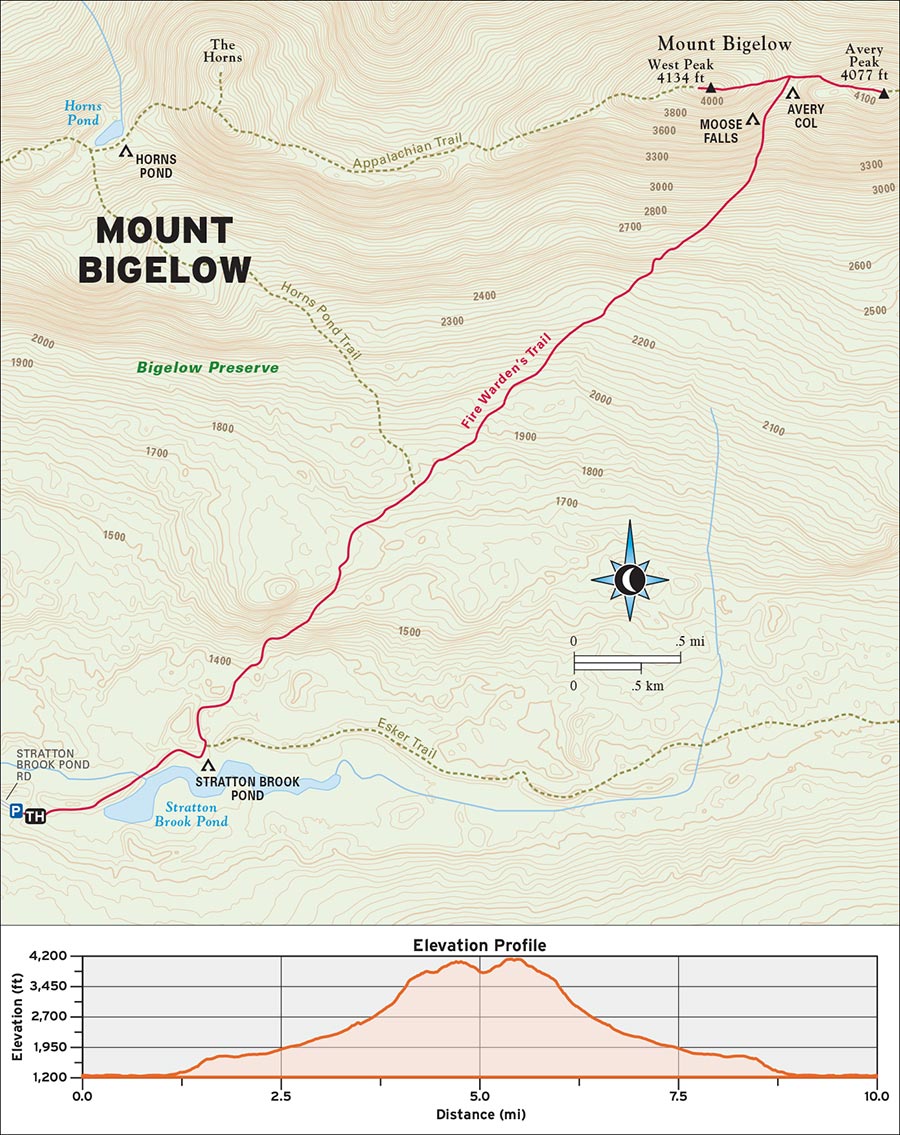
Mount Bigelow, one of the highest summits in Maine, is a remote and immense heap of granite that offers multiple peaks. The highest point on Bigelow—West Peak, at 4,145 feet—is best paired with the nearby Avery Peak for an unforgettable two-for-one climb.
 MILE 0-0.7: Trail Information Kiosk to Firewarden’s Trail
Walk to the trail information kiosk at the north end of the parking lot and pick up a rugged logging road, which climbs and then descends a small hill to reach a wooden bridge over Stratton Brook. Cross the bridge and keep right at the junction as the logging road ambles along the brook. Enjoy pretty views of a nearby marshy area and Sugarloaf Mountain in the distance. At 0.7 mile, turn left onto the Firewarden’s Trail to leave the brook behind and venture into the Bigelow Preserve.
 MILE 0.7-3.1: Firewarden’s Trail to Moose Falls Campsite
Climbing steadily at a gentle grade, the trail heads northeast with few deviations over the next mile. After climbing a steep, rocky ridge for 0.3 mile, you’ll descend into a boggy stretch of boreal pine and spruce forest at 1.7 miles. Watch your footing on the many bog bridges. Continue ascending into thicker, more deciduous woods where black bears and deer are known to wander. At 2.1 miles, keep right at the Horns Pond Trail junction to stay on the Firewarden’s Trail. Rock-hop across a creek and keep heading northeast, deeper into the woods—the trees are spaced apart just enough to allow you to admire the depth of color and texture in this forest. The footing slowly becomes rockier and steeper, and the occasional gust of wind through the trees hints at what lies ahead.
At 3.1 miles, the trail climbs a set of rock stairs to reach Moose Falls Campsite, a bare-bones tenting site that is first come, first served and used by hikers doing longer overnight treks in the Bigelow Range.
 MILE 3.1-4.2: Moose Falls Campsite to Avery Memorial Campsite
From here, the gradual ascent through the woods comes to an end. The trail crosses a nearby creek and becomes very steep and rocky, ascending a series of winding granite stairs and slabs to break through the foliage. As the boreal trees get thinner and smaller, the green expanse of northern Maine becomes partially visible, making the brutal ascent just a little more bearable. Keep climbing northeast, keeping left at the junction for Avery Memorial Campsite at 4.2 miles (this is another tenting area for overnight hikers) to stay on Firewarden’s.
 MILE 4.2-10.0: Avery Memorial Campsite to West Peak and Avery Peak Summits
Enjoy a sudden blast of alpine exposure as you step onto the open ridgeline between West Peak and Avery Peak at just over 4.2 miles, where the trail finally (mercifully) levels off a bit and concludes at the Appalachian Trail, which visits both summits. From this beautiful juncture, hikers can choose to turn left or right to either peak. The climbs are similar—rocks, boulders, tundra, and abundant views of the Rangeley Lakes, the Carrabassett Valley, and even the Quebec wilderness. Avery Peak also has the stone foundations of an old fire tower. From the AT/Firewarden’s junction, it’s about 0.4 mile round-trip to each summit. Ascend both summits for maximum victory points, then return the way you came.
From Portland, drive northeast on I-295 N for 46 miles and then merge onto I-95 N to continue northeast to Exit 113 for ME-3 toward Augusta/Belfast. At the end of the off-ramp, enter the traffic circle and take the third exit to get on ME-3 N. Another traffic circle will appear just ahead. Take the first exit to stay on ME-3 N and drive north for a mile before turning right onto ME-27 N/Civic Center Drive. Follow this road to its terminus and then make a left onto US-2 W. After a mile, turn right onto Weeks Mill Road, drive northwest for another 6 miles, and then make a very sharp right onto ME-43 E. At the fork a mile ahead, veer left onto Mosher Hill Road, continue for 3 miles, and swing left onto Ramsdell Road. Follow this road to its end and turn right onto ME-27 N. Drive north for another 33 miles and then take a right onto Stratton Brook Road at the sign for Bigelow Preserve. Follow the road to the hiker parking area.
GPS COORDINATES: 45°06'35.6"N 70°20'14.0"W, 45.109879, -70.337209
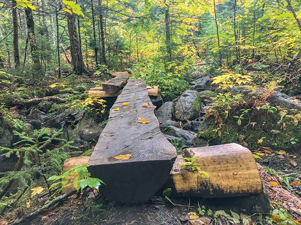
ROUGH-HEWN MAINE BOG BRIDGES AID HIKERS’ PASSAGE ALONG THE FIREWARDEN’S TRAIL
KI JO-MARY MULTIPLE USE MANAGEMENT FOREST, BROWNVILLE

Hike through the isolated Maine wilderness into the majestic Gulf Hagas, a breathtaking canyon with an abundance of waterfalls.
BEST: Brew hikes
DISTANCE: 8.2 miles round-trip
DURATION: 5 hours
ELEVATION CHANGE: 1,154 feet
EFFORT: Strenuous
TRAIL: Dirt path, rocks, wooden bog bridges, water crossings on stones
USERS: Hikers, leashed dogs
SEASON: June-September
FEES/PASSES: $15 day-use fee per person for nonresidents, $10 for Maine residents
MAPS: North Maine Woods Inc. website
CONTACT: North Maine Woods Inc., 207/435-6213, www.northmainewoods.org
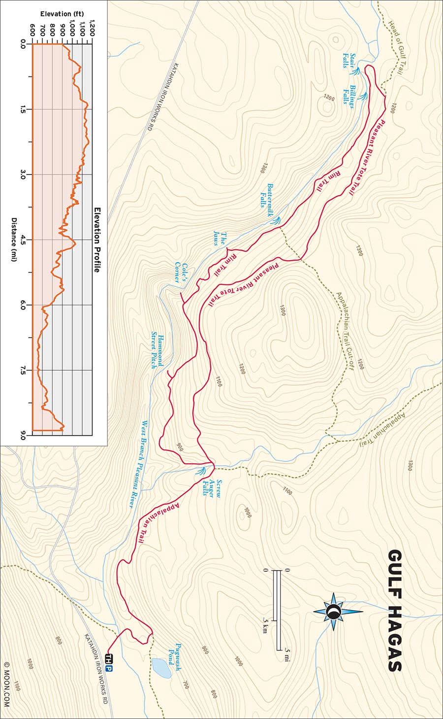
Deep in the Maine wilderness that once housed the Katahdin Iron Works furnaces, you’ll find Gulf Hagas, often referred to as “the Grand Canyon of Maine.” But this moniker doesn’t do the canyon justice—the dark gray slate cliffs are uncharacteristically sheer, the waters of the Pleasant River surge through the canyon with a monotone roar, and the curious glacial rock formations have created an abundance of pretty waterfalls.
 MILE 0-0.2: Trail Information Kiosk to Pleasant River
Begin the hike in the parking area and walk north to the trail information kiosk. Pick up the Appalachian Trail as it leads into the deciduous forest. At 0.2 mile, you’ll ford the Pleasant River, Oregon Trail-style—this crossing is too deep and wide to rock-hop, so either bring water shoes or consider removing your boots for this “initiation” into the realm of Gulf Hagas.
 MILE 0.2-1.5: Pleasant River to Appalachian Trail
On the other side of the river, veer right and follow white blazes on the trees. The trail curves away from the river and crosses some bog bridges before reaching a T-intersection at 0.4 mile. Turn left to stay on the AT and follow the trail for roughly 1 mile as it gradually climbs west through the woods over rocks and roots.
 MILE 1.5-1.8: Appalachian Trail to Rim Trail
At 1.5 miles, cross a stream to reach the junction for the Rim Trail and the Pleasant River Tote Road. Take a left onto the Rim Trail and make a rooty descent toward the sound of rushing water to reach your first cascade, Screw Auger Falls, at 1.7 miles. A few spur trails on the left lead to overlooks from which you can admire the cascade. (The Rim Trail is replete with such spur paths to canyon vistas, almost all of which are worth checking out.)
 MILE 1.8-3.0: Rim Trail to The Jaws
Continue gently descending through the woods for another 0.5 mile. As the trail begins to climb the north rim of Gulf Hagas, huff and puff your way up some winding rock staircases for another 0.2 mile. At 2.5 miles, keep left to stay on Rim Trail at the Tote Road connector junction. Enjoy your first stunning view of the canyon by taking a spur path at 2.6 miles.
Over the next half mile, the Rim Trail becomes a rocky and root-festooned roller coaster with a few steep sections that require a bit of scrambling. Check out The Jaws—a teeth-like rock formation through which the Pleasant River flows—at 3 miles.
 MILE 3.0-3.4: The Jaws to Buttermilk Falls
As the hemlock forest gets mossier, the trees start to become more spread out and the trail gets sunnier. Pass several exposed ledges that offer killer perspectives of the canyon. At 3.4 miles, you’ll reach Buttermilk Falls, and the trail climbs steadily onward.
 MILE 3.4-4.2: Buttermilk Falls to Billings Falls and Stair Falls
Keep left to stay on Rim at the second junction for the Tote Road. The trail swings in and out of the forest onto more rocky ledges and ambles past overlook points for Billings Falls at 4.1 miles and Stair Falls at 4.2 miles.
 MILE 4.2-4.3: Stair Falls to Head of Gulf Hagas
As the sound of the river dissipates, the Rim Trail dips deeper into the forest before arriving at the Head of the Gulf at 4.3 miles. This is the gorgeous delta of waterways that “feed” Gulf Hagas. Here, on a sunny day, you’ll find swimmers, fishermen, photographers, and maybe even a few thru-hikers taking a scenic detour.
 MILE 4.3-4.5: Head of Gulf Hagas to Pleasant River Tote Road
The return path seems specifically designed for those tuckered out from the exhausting climb. From the Head, take the Rim Trail north to its terminus at the junction with the Pleasant River Tote Road at 4.5 miles.
 MILE 4.5-8.2: Pleasant River Tote Road to Katahdin Iron Works Road
Turn right onto the Tote Road, which cruises through the woods on a smooth dirt path and over lots of bog bridges at a gradual downhill grade for 2.2 miles. The path effortlessly delivers you back to the beginning of the Rim Trail at 6.7 miles. Turn left onto the Appalachian Trail, recross the stream, and backtrack to reach Katahdin Iron Works Road at 8.2 miles.
From Bangor, drive north on I-95 N for 13 miles and take Exit 199 for ME-16 toward Alton/Lagrange/Milo. At the bottom of the off-ramp, turn left onto ME-16 W and follow it for 15 miles before making a slight left onto ME-16 W/ME-6 W as you pass through Lagrange. Drive northwest into Milo and turn right onto Main Street. Take an immediate slight left onto ME-11 N/Park Street and continue for another 12 miles. As you reach Prairie, veer left onto Ebermee Road, which will soon become Katahdin Iron Works Road. After the road transitions to dirt, you’ll reach the KI gatehouse. Stop here to register and pay the fee before continuing west along the road. The Gulf Hagas parking lot is clearly marked on your right.
GPS COORDINATES: 45°28'26.4"N 69°17'39.8"W
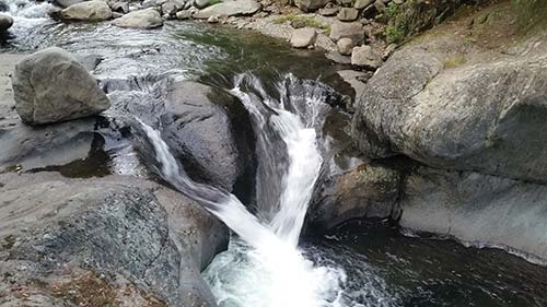
WATERFALL IN GULF HAGAS
MOUNT KINEO STATE PARK, ROCKWOOD

Take a boat ride to an island on Maine’s largest lake to climb an arrestingly steep and gorgeous mountain.
BEST: Fall hikes
DISTANCE: 3.5 miles round-trip
DURATION: 2 hours
ELEVATION CHANGE: 724 feet
EFFORT: Moderate
TRAIL: Dirt path, rocks, wooden bog bridges
USERS: Hikers
SEASON: May-October
FEES/PASSES: $12 (cash only) per adult round-trip ferry ride from Rockwood to Mount Kineo Golf Course, $3 day-use fee for the trail (honor system)
MAPS: $2 at golf course clubhouse
CONTACT: Mount Kineo Golf Course, 207/534-9012, www.mooseheadlakegolf.com; clubhouse address: 223 Young Road, Rockwood, ME
FERRY HOURS: Every 2 hours, on the hour, 9am-3pm May-June; Every hour, on the hour, 8am-6pm July-August; Every hour, on the hour, 9am-4pm September-October
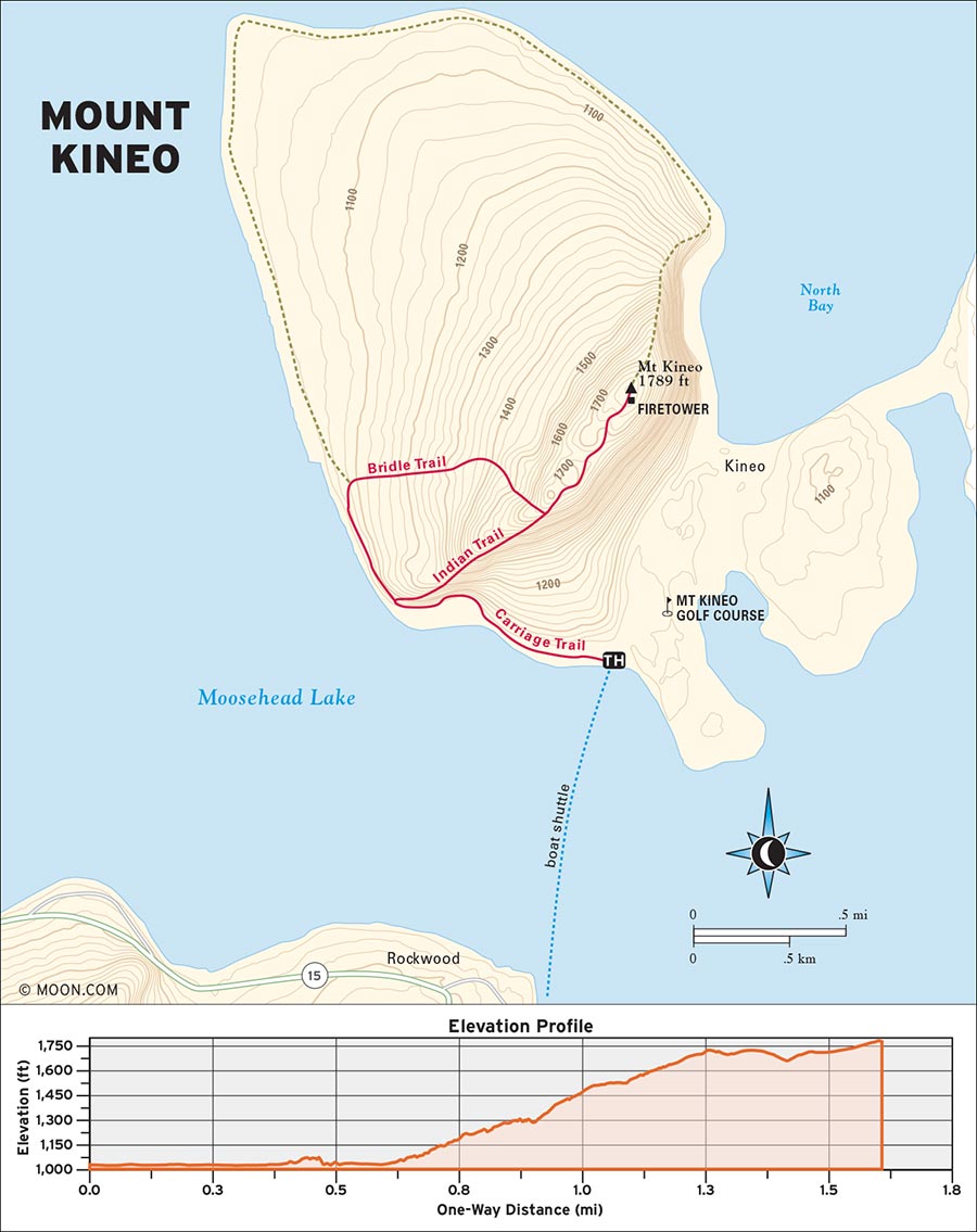
Rising above the choppy waters of Moosehead Lake like a behemoth creature carved out of stone, Mount Kineo is a spellbinding sight—the mountain is legendary for its massive rhyolite cliffs, from which Native American tribes once harvested rock for arrowheads. The way to get to the trailhead is by taking a ferry ride from the village of Rockwood to the Mount Kineo Golf Course, which sits in the shadow of the mountain.
 MILE 0-1.0: Trailhead to Indian Trail
Begin your hike to the left of the ferry dock by the large trailhead sign, featuring a map of the island. Pick up the Carriage Trail and stroll northwest along a wide gravel path that meanders along the shore of the island. In the summer, the trail is flanked by wildflowers that sprout from the tallgrass. As you enjoy the sound of water lapping at the shoreline, notice how the cliffs on your right become taller and more sheer. Within minutes, you’ll be heading up there.
Turn right at a signed junction for the Indian Trail at 0.6 mile and begin the steep, root-festooned climb up Kineo’s ledges. Blue blazes and red arrows mark the path, which heads northeast, passing a few ledges that offer spectacular views of the shoreline and the golf course. The trail becomes steeper over the next 0.3 mile, climbing over several rocky steps and ledges that require handholds. A few of the ledges are narrow and skirt perilously close to the tops of the cliffs, so tread slowly and carefully here.
 MILE 1.0-1.9: Indian Trail to Mount Kineo Summit
About 1 mile in, the Indian Trail reaches a grassy height of land that offers the best view yet. Enter the mountaintop forest for the final push to the summit. At 1.1 miles, keep right at the junction for Bridle Trail to stay on Indian Trail, continuing to amble through boreal woods with lots of moss and rocks. A final brief climb delivers you to the proper summit of Mount Kineo at 1.8 miles. The summit is wooded but it features a six-story viewing tower that can be climbed for an unbeatable view of Moosehead Lake. The tower is higher than it looks, and climbing it is easily the scariest part of the hike, but it’s well worth the effort.
 MILE 1.9-2.2: Mount Kineo Summit to Bridle Trail
To return, backtrack down the Indian Trail to the junction for the Bridle Trail at 2.2 miles and turn right onto the Bridle Trail. Descend the western haunch of Kineo at a pleasant grade for just over half a mile (blue blazes mark this path too). The path is gentler than the Indian Trail, but no less rocky and rooty.
 MILE 2.2-3.5: Bridle Trail to Carriage Trail
After passing through a grove of hemlock and spruce, the trail crosses some bog bridges and rejoins the Carriage Trail at 2.9 miles. Veer left onto the Carriage Road, keep right at the Indian Trail junction just ahead to stay on the Carriage Road, and retrace your steps along the shore until you reach the trailhead at 3.5 miles.
From Portland, drive northeast on I-295 N for 46 miles and then merge onto I-95 N to continue heading northeast. Take Exit 150 for Somerset Avenue toward Pittsfield/Hartland. Turn left onto Somerset Avenue at the end of the off-ramp and then take a right onto Spring Road. Follow the road to its terminus and veer left onto ME-152. Drive north on ME-152 until the highway concludes in Cambridge, where you’ll make a right turn onto ME-150. Continue along ME-150 to the town of Guilford and turn left onto ME-15 N/ME-6 W. Drive northwest to Greenville, veer left onto Pritham Avenue, and then take a right at the road’s end to continue along ME-15 N/ME-6 W. Head northwest along the shores of Moosehead Lake for another 17 miles, enter the village of Rockwood, and make a final right turn onto Village Road, which descends to the parking lot for the Kineo shuttle ferry. Walk to the nearby dock to catch the boat.
GPS COORDINATES: 45°40'36.5"N 69°44'18.8"W, 45.676793, -69.738555
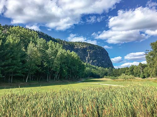
MOUNT KINEO
BANGOR CITY FOREST, BANGOR, AND ORONO BOG, ORONO

This boardwalk loop through a beautiful bog is especially nice for bird-watchers, families, and couples on a sunset stroll.
DISTANCE: 1.6 miles round-trip
DURATION: 45 minutes
ELEVATION CHANGE: 27 feet
EFFORT: Easy
TRAIL: Dirt path, boardwalk
USERS: Hikers
SEASON: May-November
FEES/PASSES: None
MAPS: University of Maine Orono Bog Walk website
CONTACT: University of Maine, 207/581-1865, www.umaine.edu/oronobogwalk
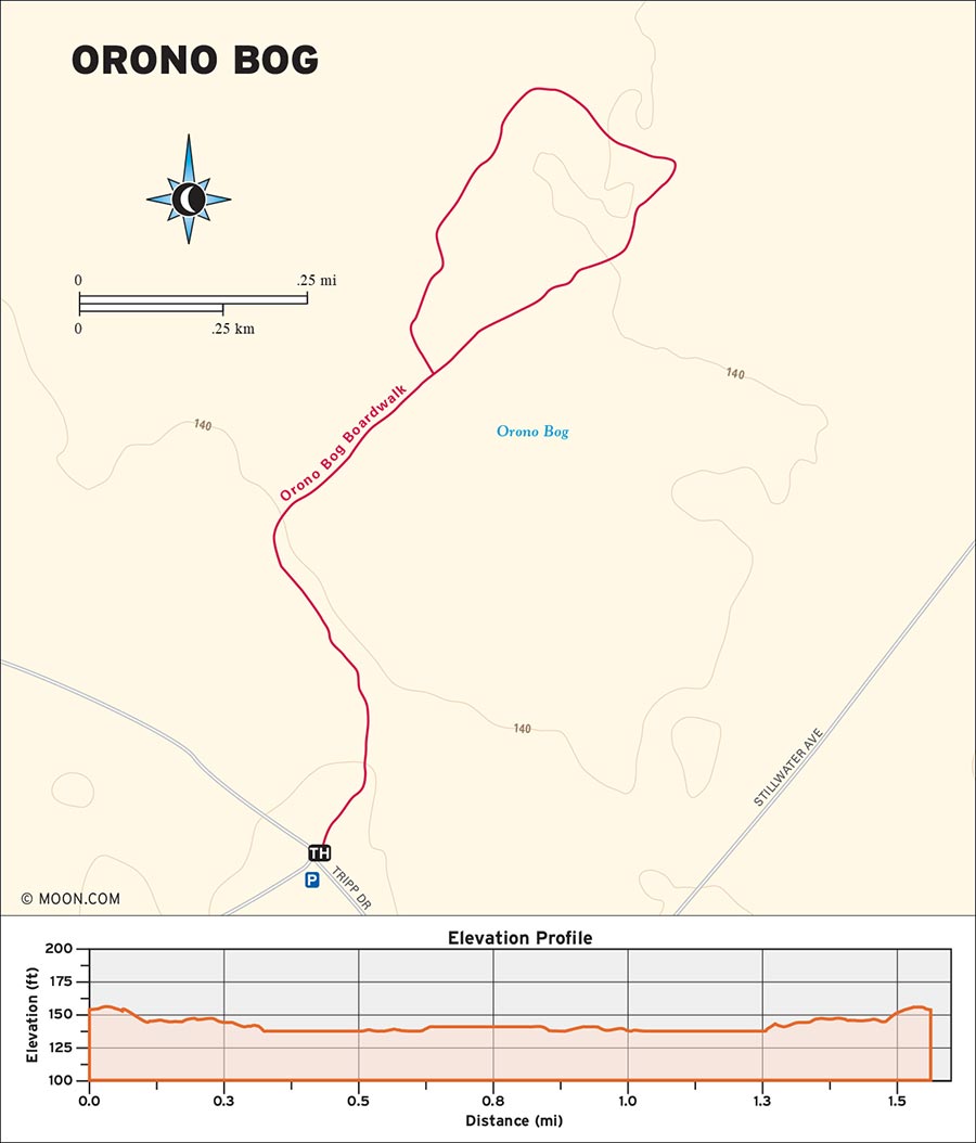
Tucked away in Bangor’s public forest is Orono Bog—a 616-acre conservation area that’s teeming with wildlife and vivid green peat moss so thick that it actually constitutes a small height of land at the center of the bog. This walk is especially nice during the evening “magic hour” when the lighting is softer.
 MILE 0-0.4: East Trail to Orono Bog Boardwalk
Walk to the northeast end of the parking area to the wooden sign for the East Trail. Go 0.3 mile northeast along this gravel path that meanders through an airy forest of spruce and cedar trees. Upon reaching a clearing with picnic tables and an information kiosk, take a right turn onto the Orono Bog Boardwalk entrance.
 MILE 0.4-0.6: Orono Bog Boardwalk to Orono Bog
Continue northeast along the first section of boardwalk as it takes you through a much thicker, diverse stretch of forest. Some pieces of the boardwalk are actually resting on the bog surface, so don’t be worried if they bounce like a floating dock. Colorful signs are placed throughout the boardwalk to give visitors an idea of the many bird, mammal, and reptile species that call the bog home. The boardwalk splits at 0.5 mile; bear right and keep heading northeast through an airier grove of spruce. The landscape suddenly opens up into an panorama of peat moss in countless shades of green. You’re officially in Orono Bog now.
 MILE 0.6-1.0: Orono Bog
As the bog boardwalk curves north and then northwest over the next 0.3 mile, watch the sky for northern harriers. Not only do these medium-size raptors make regular appearances around the bog, but the trees and shrubs here are less than 10 feet tall, offering birders a prime view. The boardwalk starts to turn west and passes through a stretch of young spruce. Around here the boardwalk is slightly more raised, but it’s still close enough to the peat for hikers to spot a northern leopard frog hopping around on the surface.
 MILE 1.0-1.6: Orono Bog to Orono Bog Boardwalk
The trail heads southeast for 0.3 mile as the boardwalk loop draws toward its close. Be sure to take a good final whiff of the air—some of the herbs that grow around here are bog variations of laurel and rosemary. The boardwalk loop enters forest again, reaching its origin point at 1.1 miles. From here, you can turn left and backtrack to the parking lot or explore more of the Bangor City Forest trails.
From Portland, take I-95 north to the Bangor area. Take Exit 186 for Stillwater Avenue and then turn right onto Stillwater Avenue. Take Stillwater Avenue northeast for 2.6 miles and then make a left turn onto Tripp Drive. The Bangor City Forest parking lot is at the end of this quiet road.
GPS COORDINATES: 44°51'46.1"N 68°43'42.1"W, 44.862799, -68.728366
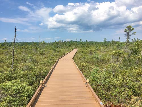
THE BOARDWALK THROUGH ORONO BOG
BAXTER STATE PARK, MILLINOCKET

This forest hike visits two explosive waterfalls that spill from the height of Baxter State Park into the valley below.
DISTANCE: 2.4 miles round-trip
DURATION: 1.5 hours
ELEVATION CHANGE: 185 feet
EFFORT: Easy
TRAIL: Dirt path, rocks, wooden bog bridges
USERS: Hikers
SEASON: June-October
FEES/PASSES: $15 park entrance fee per vehicle
MAPS: Baxter State Park website
CONTACT: Baxter State Park, 207/723-5140, www.baxterstatepark.org
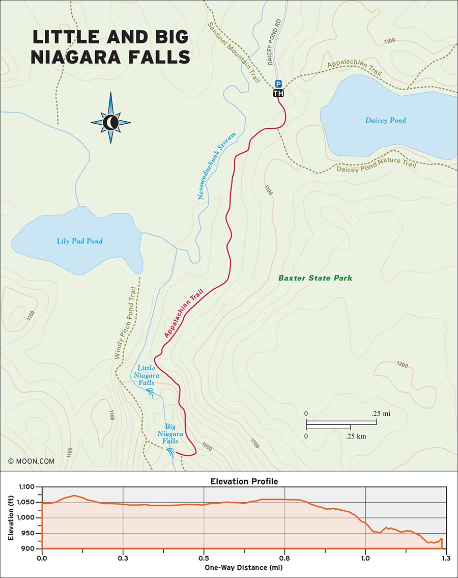
 MILE 0-0.2: Trail Kiosk to Daicey Pond Nature Trail Junction
Begin the hike at the southwest corner of the parking lot by the trails kiosk. Look for the wooden Appalachian Trail sign for Little and Big Niagara on a nearby tree; briefly walk east along a dirt path through tall grass, then turn left as the trail veers into a mixed forest of beech and pine. Look for white blazes on trees. The footing quickly becomes rockier and muddier but is made easier by lots of wooden bog bridges. Turn right at the two junctions with the Daicey Pond Nature Trail to continue your hike toward the falls.
 MILE 0.2-0.9: Daicey Pond Nature Trail Junction to Little Niagara Falls Cutoff Path
Listen for the sound of rushing water before the trail reaches Nesowadehunk Stream at 0.3 mile.
As you continue south beside the water, the trail begins to descend through the increasingly mossy and rocky forest at a gentle grade. Big glacial boulders are visible in the surrounding woodland, rich with those classic Maine ferns. The roar of the stream gradually grows louder, and at 0.9 mile the trail reaches a sign for the cutoff path to Little Niagara Falls.
 MILE 0.9-1.0: Little Niagara Falls Cutoff Path to West Peak and Doubletop Mountain Viewpoint
Turn right onto the cutoff and emerge onto an open rock slab that the falls spill around. This cascade resembles a sloped series of rapids, but in times of high water they take on a powerful frothing appearance. The falls outlook point also offers a killer view of nearby West Peak and Doubletop Mountain to the north.
 MILE 1.0-1.2: West Peak and Doubletop Mountain Viewpoint to Big Niagara Falls Cutoff Path
To reach the grand finale, backtrack to the AT and turn right to continue the hike. The trail veers away from the stream and descends at a more moderate grade, with plenty of exposed roots—be careful of these during soggy conditions. As the hemlock woods become more spacious and sunlit, the trail descends several rock stairs to reach the cutoff path for Big Niagara Falls at 1.2 miles.
 MILE 1.2-2.4: Big Niagara Falls Cutoff Path to Big Niagara Falls
Turn right here and briefly walk through the undergrowth to reach a ledge that overlooks the gargantuan waterfall. Big Niagara Falls lives up to its name, exploding outward in great torrents and spilling down several 20-foot cliffs to form a larger stream below that contains several rock islands on which trees have managed to grow. Chances are you’ll be sharing the ledge with some thru-hikers. Return the way you came.
From Bangor, drive north on I-95 N for roughly 58 miles and then take Exit 144-244 for ME-157 toward Medway/Millinocket. Turn left at the bottom of the off-ramp, drive northwest along ME-157 W/Medway Road until its terminus, and then take a right onto Katahdin Road. Turn left onto Bates Street and drive northwest for 8 miles as Bates Street becomes Millinocket Road and then Baxter Park Road. Continue north to the Togue Pond Gate House for Baxter State Park, pay the $15 entrance fee, and turn left at the fork onto Park Tote Road. Drive along the winding dirt road for roughly 10 miles and then make a left onto Daicey Pond Road. You’ll arrive at the parking lot in an exposed grassy area just over half a mile ahead.
GPS COORDINATES: 45°52'57.5"N 69°01'54.6"W, 45.882644, -69.031825
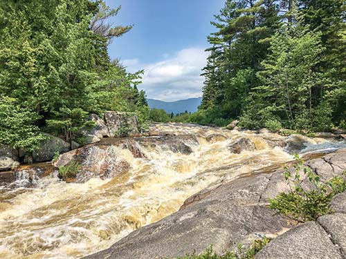
LITTLE NIAGARA FALLS
BAXTER STATE PARK, MILLINOCKET

Traverse a swampy forest and ascend a bald-faced peak for top-notch views of Katahdin.
DISTANCE: 3.6 miles round-trip
DURATION: 2.5 hours
ELEVATION CHANGE: 1,558 feet
EFFORT: Moderate/strenuous
TRAIL: Dirt path, rocks, wooden bog bridges, water crossings via stones
USERS: Hikers
SEASON: May-October
FEES: $15 park entry fee per vehicle
MAPS: Baxter State Park website
CONTACT: Baxter State Park, 207/723-5140, www.baxterstatepark.org
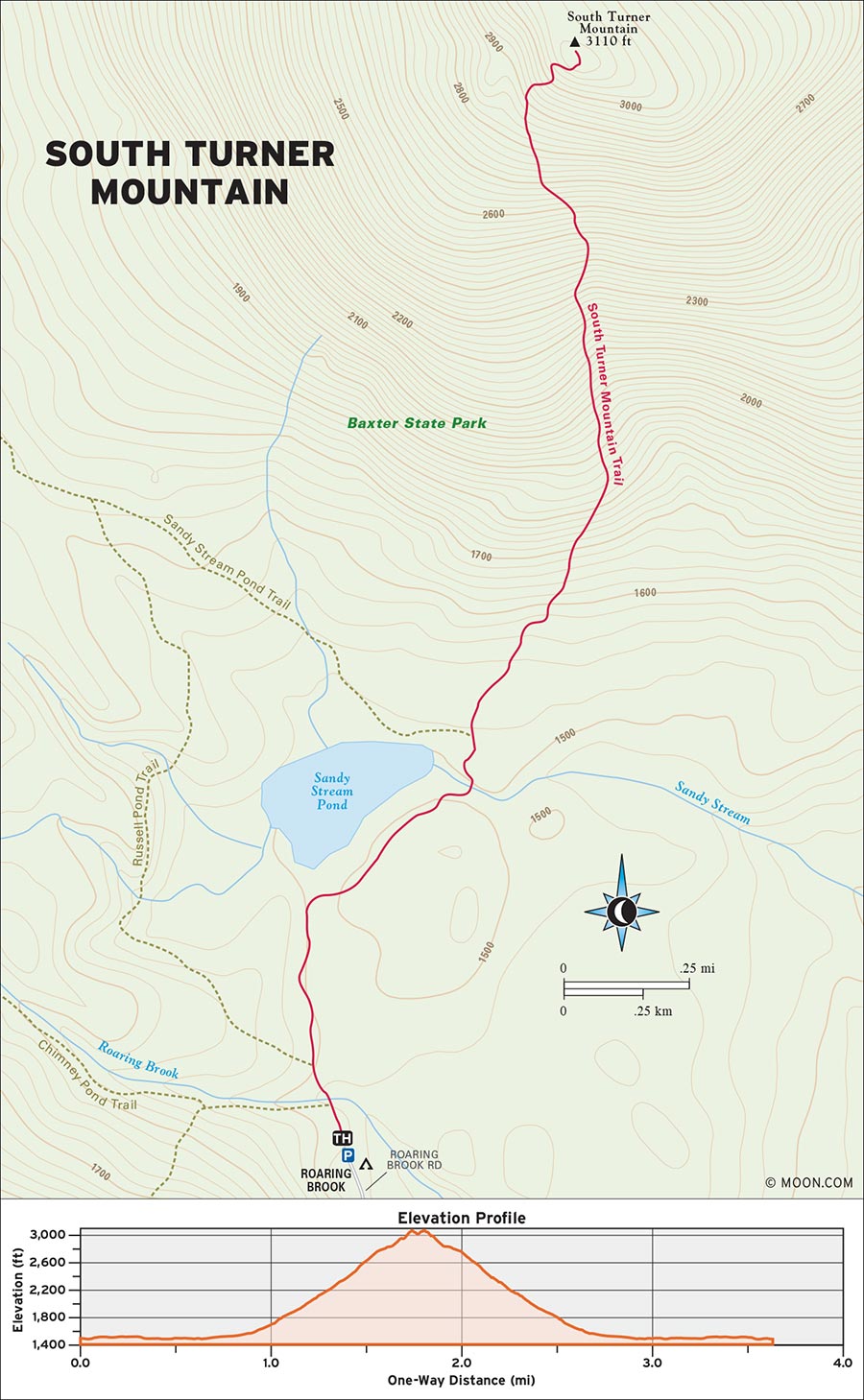
Located directly east of the iconic Katahdin, South Turner offers a challenging climb and scenic vistas without taking up a whole day. It’s a perfect choice for hikers who are preparing for a Katahdin expedition or forgoing the big one altogether. Note that weekend visitors should reserve a parking spot at the Roaring Brook Campground parking lot two weeks in advance by using the Baxter State Park online reservations system. Many trails start from this lot, and it’s almost always full on Saturdays and Sundays.
 MILE 0-0.3: Ranger Cabin to South Turner Mountain Trail
Begin the hike just beyond the ranger cabin at the north end of the parking lot. Cross a large wooden footbridge over Roaring Brook. At the nearby trail junction, turn right onto the South Turner Mountain Trail. Enjoy a brief, gravelly stretch of level pathway and follow blue blazes as you saunter northeast through a moist and mossy forest. At 0.3 mile, a section of boardwalk takes you deeper into the forest before it transitions into rough-hewn bog bridges.
 MILE 0.3-0.5: South Turner Mountain Trail to Sandy Stream Pond
Continue northeast as the trail swings past Sandy Stream Pond and passes several little spur trails that lead to scenic points on the edge of the pond. Listen for the twang of local frogs—and, if you choose to check out any of the scenic cutoffs, watch the shoreline for moose, especially in the late afternoon or evening.
 MILE 0.5-0.7: Sandy Stream Pond to South Turner Mountain Trail
The trail leaves the pond behind and ascends gradually before reaching the junction with the Sandy Stream Pond Trail at 0.7 mile. Veer right to stay on the South Turner Mountain Trail. Mind your footing as the trail crumples into a jumble of big mossy rocks.
 MILE 0.7-1.7: South Turner Mountain Trail to South Turner Knife Edge Ridge
Pick your way over the rocks and note the vernal pools on both sides of the trail. One mile in, the trail steepens considerably and ascends a series of rock stairs that slab northward up the mountainside. A few fleeting views through the birch and pine trees will give you a sense of how much elevation you’re gaining within less than a mile (it’s a lot). As the trees begin to shrink and the ground becomes much more eroded, the trail pops out onto the sun-kissed southern shoulder of South Turner at 1.7 miles. Enjoy a spectacular panorama of Katahdin’s eastern heights—which include the notorious, razor-thin Knife Edge ridge where hikers go to test their self-preservation instincts.
 MILE 1.7-1.8: South Turner Knife Edge Ridge to South Turner Summit
To continue to the summit proper, head northeast and ascend an alternating series of rock stairs and large boulders (some of which necessitate scrambling). You’ll reach the barren, knob-shaped summit at 1.8 miles. Return the way you came.
From Bangor, drive north on I-95 N for roughly 58 miles and then take Exit 144-244 for ME-157 toward Medway/Millinocket. Turn left at the bottom of the off-ramp, drive northwest along ME-157 W/Medway Road until its terminus, and then take a right onto Katahdin Road. Turn left onto Bates Street and drive northwest for 8 miles as Bates Street becomes Millinocket Road and then Baxter Park Road. Continue north to the Togue Pond Gate House for Baxter State Park, pay the entrance fee, and veer right at the fork onto Roaring Brook Road. Drive along the winding dirt road for about 8 miles to reach the Roaring Brook Campground parking lot.
GPS COORDINATES: 45°55'10.8"N 68°51'26.5"W, 45.919667, -68.857352
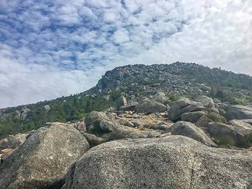
SOUTH TURNER MOUNTAIN'S SUMMIT
DEBSCONEAG LAKES WILDERNESS AREA, MILLINOCKET

This gentle wooded path has an awesome surprise at the end—a series of caves that retain their natural ice throughout the year.
BEST: New England oddities
DISTANCE: 2 miles round-trip
DURATION: 1 hour
ELEVATION CHANGE: 158 feet
EFFORT: Easy
TRAIL: Dirt path, rocks, wooden bridges, river crossings on stones, metal ladders
USERS: Hikers
SEASON: May-September
FEES/PASSES: None
MAPS: The Nature Conservancy website
CONTACT: The Nature Conservancy, 207/729-5181, www.nature.org
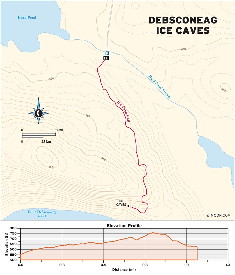
Hidden deep in the forest of the Debsconeag Wilderness Area, the Debsconeag Ice Caves are chock-full of ice that can last beyond July. Hikers will want to have boots with good tread, and parents with small children might want to skip this one. Traction isn’t necessary for exploring the ice caves—boots with good grip, and a healthy dose of caution, will suffice.
 MILE 0-0.6: Trailhead to Glacial Boulders
Begin the hike by walking toward the red gate at the south end of the parking lot. Cross a large wooden bridge, then make a left as the dirt trail veers into the woods. Blue blazes mark the path forward. The trail crosses a few creeks on stones and ambles south through deciduous forest with plenty of young spruce and cedar trees. Look out for bear and moose scat—the woods here have a very active mammal population.
As the trail starts to ascend gradually, the trees on your left will begin to part and offer fleeting views of the Debsconeag Wilderness expanse, including the Penobscot River. Abundant ferns add some color along the trail. Continue hiking south as the trail narrows into a ledge and takes you along the flank of a broad hillside. Note the glacial boulders that begin to appear around 0.6 mile.
 MILE 0.6-1.0: Glacial Boulders to Debsconeag Ice Caves
After another 0.2 mile, the trail reaches a junction with a sign for the ice caves. Turn left here, descend through a dreamy, mossy stretch of woods, and then turn right at a second junction (also affixed with a sign for the ice caves). Walk west toward a looming garden of glacial boulders and reach the entrance to the Debsconeag Ice Caves at 1 mile.
 MILE 1.0-2.0: Debsconeag Ice Caves and Return to Trailhead
You can climb down into the caves by using the metal rungs that are installed in the rock walls, but be careful upon reaching the bottom: The floor of the cave is sheer ice and very slippery. A guide rope affixed to the right wall of the cave offers some support. If you feel like venturing deeper into the abyss, you’ll want to have a reliable light source. Solo hikers should take extra caution when exploring the cave. When you’re done exploring, return the way you came.
From Bangor, drive north on I-95 N for roughly 58 miles and then take Exit 144-244 for ME-157 toward Medway/Millinocket. Turn left at the bottom of the off-ramp, drive northwest along ME-157 W/Medway Road until its terminus, and then take a right onto Katahdin Road. Turn left onto Bates Street and drive northwest for 8 miles as Bates Street becomes Millinocket Road and then Baxter Park Road. After passing the Big Moose Inn, take a left and then turn right to merge onto Golden Road. Drive carefully along this pothole-filled logging road for another 10 miles. Immediately after crossing Abol Bridge, turn left onto the dirt road flanked by a large Nature Conservancy sign. Drive south for about 3 miles. Veer left at the fork and continue for another mile until you reach the Debsconeag Ice Caves parking lot on the right side.
GPS COORDINATES: 45°47'29.2"N 68°58'41.4"W, 45.791449, -68.978171
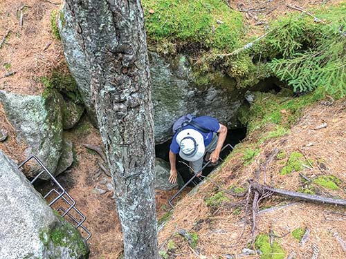
DESCEND INTO DEBSCONEAG ICE CAVES.
BAXTER STATE PARK, MILLINOCKET

Hike through forest to visit one of the most wonderous places in Maine—a massive exposed rock slab decorated with rivulets of rushing water.
BEST: Spots for a swim
DISTANCE: 3.6 miles round-trip
DURATION: 1.5 hours
ELEVATION CHANGE: 263 feet
EFFORT: Easy
TRAIL: Dirt path, rocks, wooden bridges
USERS: Hikers
SEASON: May-September
FEES/PASSES: None
MAPS: Baxter State Park website
CONTACT: Baxter State Park, 207/723-5140, www.baxterstatepark.org
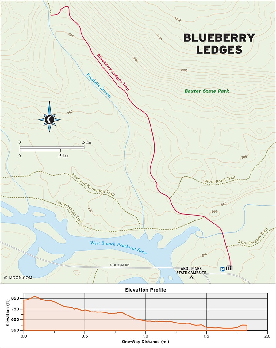
Blueberry Ledges is a rolling expanse of exposed rock cuts on the southern border of Baxter State Park. What makes this place special are the chutes of water that spill down the rocky ledges—putting the “blue” in blueberry. In spring and early summer, the snowmelt turns the entire mess of slides into a big torrent of rushing water, which funnels into watery chutes that hikers can ride into pools of (very cold) water. This feature makes Blueberry Ledges a popular stop for thru-hikers who’ve just finished the trail and are craving a celebratory cool-down.
 MILE 0-0.3: Twin Woodsheds to Baxter State Park
Begin the hike by the twin woodsheds in the north end of the parking lot. Walk toward the Northern Outdoors sign, pass through the trees, and turn left onto a dirt road. Walk north along the road to an open marsh area and cross a wooden log bridge over a creek. This bridge marks your official entry point into Baxter State Park.
 MILE 0.3-0.6: Baxter State Park to Blueberry Ledges Trail
Enter the forest on the other side of the bridge and continue northwest to the trail information kiosk at 0.4 mile. Make a right turn here onto the Abol Pond Trail. The trail climbs a hill before leveling off and reaching a junction for the Blueberry Ledges Trail at 0.6 mile.
 MILE 0.6-1.8: Blueberry Ledges Trail to Blueberry Ledges
Turn left onto the Blueberry Ledges Trail and enjoy a meandering stroll through a hall of beautiful white birch trees. The undergrowth is rich with multiple fern species, but the trail remains wide and smooth. As the trail begins to ascend at a gradual grade, the surrounding woods become more diverse, with cedar trees making appearances.
At 1.1 miles, keep an eye out for a dirt cutoff path on the left. This little spur leads down to the bottom of the Blueberry Ledges, where hikers can admire some seasonal cascades during the wettest months. To continue to the real deal, keep hiking northwest along the main trail as it becomes narrower and rockier. Cross several muddier sections on wooden bog bridges and stones. As the trail ascends, small cairns begin to appear. Emerge onto an open rock face dotted with balsam firs and climb to a large rock straight ahead, where the ground becomes level. Take a sharp left here and enjoy the full grandeur of Blueberry Ledges, which appears before you as a hilly landscape of exposed rock, water, and spare groves of trees and vegetation. Even from afar, the chutes of water are visible as they wind their way down the expanse. Descend another sloped rock face as you head toward the ledges. Watch your step, as the rock gets wet in places—especially where black moss is growing.
 MILE 1.8-3.6: Blueberry Ledges to Blueberry Ledges Pools
At 1.8 miles, the trail reaches a swirling pool fed by chutes. From here, hikers can scramble up and across the ledges to explore them further. There are several choice swimming holes in the vicinity, though hikers should be careful to note the presence of large tree branches and blowdowns before taking a dip. Some of the larger rivulets can carry woodland debris down the ledges, adding to the otherworldly appearance of this place. Return the way you came.
From Bangor, drive north on I-95 N for roughly 58 miles and then take Exit 144-244 for ME-157 toward Medway/Millinocket. Turn left at the bottom of the off-ramp, drive northwest along ME-157 W/Medway Road until its terminus, and then take a right onto Katahdin Road. Turn left onto Bates Street and drive northwest for 8 miles as Bates Street becomes Millinocket Road and then Baxter Park Road. After passing the Big Moose Inn, take a left and then turn right to merge onto Golden Road. Drive carefully along this pothole-filled logging road for another 10 miles. As you approach the Abol Bridge Campground store, pull a U-turn-esque right onto a dirt road, then make another left onto a dirt road. Ahead, on your left, you’ll see a gravel parking area with twin woodsheds.
GPS COORDINATES: 45°50'08.5"N 68°57'35.7"W, 45.835687, -68.959929
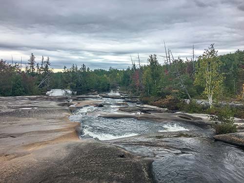
BLUEBERRY LEDGES POOLS
BAXTER STATE PARK, MILLINOCKET

The tallest mountain in Maine and the northern terminus of the Appalachian Trail is a once-in-a-lifetime climbing experience that will take your breath away.
BEST: Summer hikes, vistas
DISTANCE: 9.4 miles round-trip
DURATION: 8.5 hours
ELEVATION CHANGE: 4,077 feet
EFFORT: Strenuous
TRAIL: Dirt path, rocks, iron rungs, wooden bridges
USERS: Hikers
SEASON: June-September
FEES/PASSES: $15 park entrance fee, optional $5 parking reservation fee
MAPS: Baxter State Park website
CONTACT: Baxter State Park, 207/723-5140, www.baxterstatepark.org
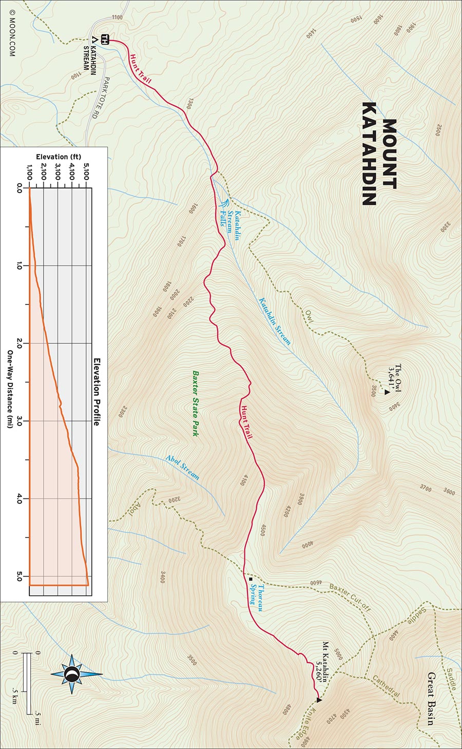
Various trails lead to the summit, all of which require you to climb hundreds of rock stairs through boreal forests, scale perilous ledges, and scramble through mazes of boulders. Because Katahdin is the northern terminus of the Appalachian Trail, the route below follows the Hunt Trail—the official AT ascent route.
Baxter State Park limits the number of hikers on Katahdin each day. There are three parking lots from which the Katahdin trails depart and most of the spaces in those lots are reserved by hikers in advance. (A limited number of first-come, first-served spots are handed out when the park opens at 6am each morning, and people will line up to grab them.)
Reservations can be made online or by phone. Maine residents can book summer parking spots in advance starting in April and non-Mainers can reserve their spots two weeks before their hiking date. Weekends are far more competitive and there is no parking allowed on the sides of the roads in the park.
 MILE 0-1.0: Hunt Trail Trailhead to The Owl
Begin the hike in the clearing beside the day-use parking lot. The Hunt Trail begins on the north end of the clearing by a post with a white blaze. Check the trailhead for bridge closure notices. If the bridge is out and you're comfortable crossing Katahdin Stream on wet rocks, take the Hunt Trail north along a gentle stony path. Veer right at the junction for The Owl at 1 mile and carefully cross Katahdin Stream. If you don’t want to risk getting wet, take the Katahdin Stream bypass route from the trailhead by crossing a large wooden bridge over Katahdin Stream, walking east along a gravel road, and picking up the signed bypass trail on your left. Just like the original Hunt Trail, it lumbers north through the woods at a patient grade until it converges with the Hunt Trail. (Note the outhouse beside Katahdin Stream: this is your last chance to relieve yourself in relative comfort.)
 MILE 1.0-2.5: The Owl to Boulders
From here, the trail ascends a series of sloped rock faces that emerge from the trees and passes the beautiful Katahdin Stream Falls at 1.1 miles. Keep following the white blazes as the trail becomes a sequence of rock stairs that grow progressively steeper and rougher for the next mile. Gradually, the stairs transition to dicier rock scrambles, and the trees open up a bit to reveal some killer views of The Owl, a craggy peak that sits to Katahdin’s west. Then, quite suddenly, the trail fully emerges from the trees at 2.5 miles and arrives at a jumble of house-sized boulders.
 MILE 2.5-2.8: Boulders to Hunt Spur
This is where the hike truly becomes a climb, as the Hunt Trail scales the boulders with the assistance of some iron rungs and pegs that have been installed along the trail to help hikers pull themselves over the gargantuan rocks. This is a tough and often scary section of trail that requires concentration, caution, and considerable upper-body strength. After bypassing the last of the boulders, the trail levels out and reaches Hunt Spur at 2.8 miles. This is one of the most incredible parts of the hike. The upper heights of Katahdin are now in sight, but to get there, you must scale the exposed and dizzyingly steep ridge of Hunt Spur.
 MILE 2.8-3.7: Hunt Spur to Katahdin Tableland
For the next half mile, the trail works its way up the spur, over all manner of crags and cliffs. (Don’t stray from the white-blazed climbing route.) Take a break to recover your breath and drink in the beauty of the surrounding landscape: a sea of green trees and blue lakes. After a final stretch of ledges, the trail reaches the tableland of Katahdin at 3.1 miles and segues into a gorgeous amble across a windswept plateau of tundra and rocks.
 MILE 3.7-9.4: Katahdin Tableland to Mount Katahdin Summit
Veer left at the junction with the Abol Trail at 3.7 miles to stay on Hunt. Slather on some sunscreen here—it will be at least another hour or two before you’re back in the shade of the trees. The trail curves to the northeast and climbs a series of rock steps. Just ahead, you’ll likely notice a gaggle of hikers. At 4.7 miles, you will arrive at the summit of Mount Katahdin, which offers an awe-inspiring panoramic view of Maine’s deep green northern wilderness. Take your time at the top and assess your physical condition before making your descent. For hikers uncomfortable with the prospect of venturing down the technical portions of the boulder field, the Abol Trail offers a less tricky (but relentlessly steep) alternative descent that finishes roughly 2.4 miles down the road from the Katahdin Stream Campground. Otherwise, returning by way of the Hunt Trail is the “easiest” way back down.
From Bangor, drive north on I-95 N for roughly 58 miles and then take Exit 144-244 for ME-157 toward Medway/Millinocket. Turn left at the bottom of the off-ramp, drive northwest along ME-157 W/Medway Road until its terminus, and then take a right onto Katahdin Road. Turn left onto Bates Street and drive northwest for 8 miles as Bates Street becomes Millinocket Road and then Baxter Park Road. Continue north to the Togue Pond Gate House for Baxter State Park, pay the $15 entrance fee, and turn left at the fork onto Park Tote Road. Drive along the winding dirt road for roughly 8 miles and then turn right at the sign for Katahdin Stream Campground parking.
GPS COORDINATES: 45°53'11.7"N 68°59'59.1"W, 45.886588, -68.999748
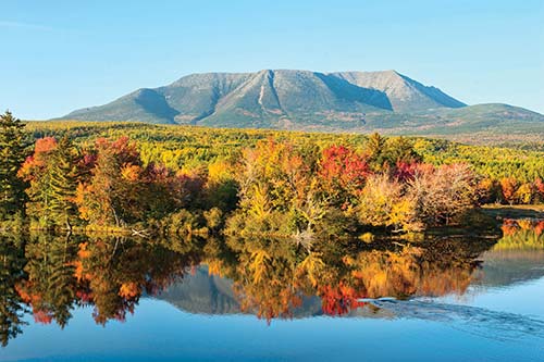
MOUNT KATAHDIN
| NEARBY CAMPGROUNDS | ||||
|---|---|---|---|---|
| NAME | LOCATION | FACILITIES | SEASON | FEE |
| Wilderness Edge Campground | 71 Millinocket Lake Rd., Millinocket, ME 04462 | Tent sites, rental tents, cabin tents, RV sites, RV rentals, toilets, showers, potable water, laundry, camp store, Wi-Fi | early May through mid-October | $14-69 |
| 207/447-8485, www.wildernessedgecampground.com | ||||
| Big Moose Inn Cabins & Campground | 5 Frederickas Way, Millinocket, ME 04462 | Tent sites, lean-tos, RV sites, cabins, hotel rooms, toilets, showers, potable water, camp store, restaurant, Wi-Fi | June-late October | $13-840 |
| 207/723-8391, www.bigmoosecabins.com | ||||
| Katahdin Stream Campground | Appalachin Trail/Katahdin Stream, Millinocket, ME 04462 | Tent sites, lean-tos, toilets | mid-May through late October | $32 (plus $15 park entry fee) |
| 207/723-5140, www.baxterstatepark.org | ||||
| Roaring Brook Campground | Chimney Pond Trail, Millinocket, ME 04462 | 75 RV sites | mid-April–October | $20 |
| 207/723-5140, www.baxterstatepark.org | ||||
| Abol Bridge Campground | 3969 Golden Rd., Mile 19, Millinocket, ME 04462 | Tent sites, RV sites, cabins, toilets, showers, camp store, restaurant, Wi-Fi | late May through September | $25-250 |
| 207/447-5803, www.abolcampground.com | ||||
| Big Eddy Cabins & Campground | Golden Rd., Millinocket, ME 04462 | Tent sites, cabins, RV sites, toilets, showers, potable water, Wi-Fi | early May through mid-October | $13-96 |
| 207/882-7323, www.bigeddy.chewonki.org | ||||
| Moosehead Family Campground | 312 Moosehead Lake Rd., Greenville, ME 04441 | Tent sites, RV sites, toilets, showers, potable water, camp store, Wi-Fi | mid-May through mid-October | $30-54 |
| 207/695-2210, www.mooseheadcampground.com | ||||
| Balsam Woods Campground | 112 Pond Rd., Abbot, ME 04406 | Tent sites, RV sites, cabins, toilets, showers, potable water, laundry, swimming pool, camp store, Wi-Fi | late May through mid-October | $32-135 |
| 207/876-2731, www.balsamwoods.com | ||||
| Deer Farm Camps | 495 Tufts Pond Rd., Kingfield, ME 04947 | Tent sites, RV sites, cabins, toilets, showers, potable water, laundry, camp store | mid-May through mid-October | $18-60 |
| 207/265-4599, www.deerfarmcamps.com | ||||
| Cathedral Pines Campground | 945 The Arnold Trl., Eustis, ME 04936 | Tent sites, RV sites, toilets, showers, potable water, laundry, Wi-Fi | mid-May through September | $32-40 |
| 207/246-3491, www.gopinescamping.com | ||||