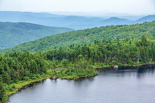
LAKE SOLITUDE, TUCKED JUST BENEATH THE SUMMIT OF MOUNT SUNAPEE
Most of us have heard illustrious tales of summers on Lake Winnipesaukee, but in New Hampshire, the famed lake is just the start. The Lakes District is home to many such bodies of water, all of which provide the type of aquatic bliss that’s worth traveling for. Just as essential are the local trails that can make a swim more refreshing. In the Lakes District, you can climb a mountain without completely wearing out your calves, glimpse wild animals and birds without disappearing into wild territory, and enjoy old-school cooking and shopping in towns such as Tamworth and Sandwich. And if your heart desires, you can even rent a boat and do your best Miami Vice impression on New Hampshire waters.

LAKE SOLITUDE, TUCKED JUST BENEATH THE SUMMIT OF MOUNT SUNAPEE
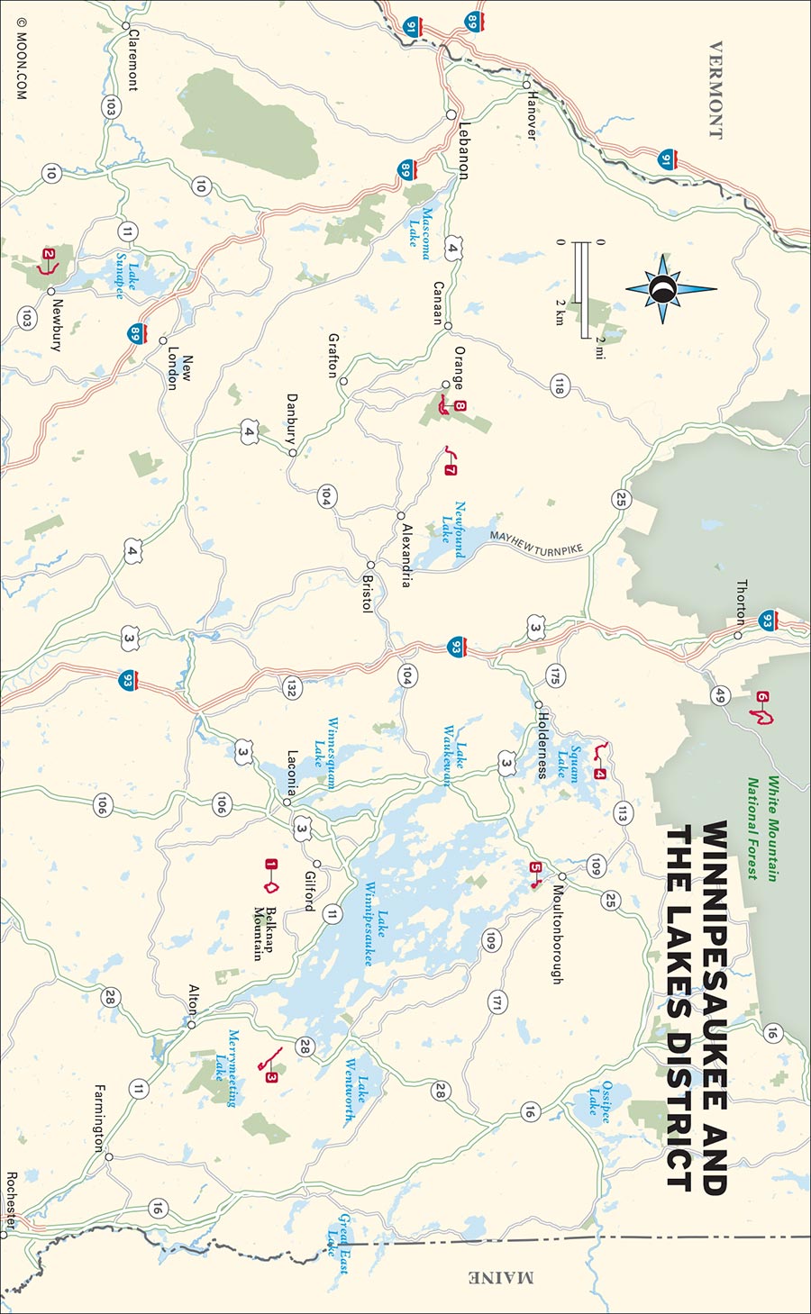
BELKNAP MOUNTAIN STATE FOREST, GILFORD

Escape the tourist hordes of Lake Winnipesaukee on this hike, which passes the ruins of a crashed plane and ends at a fire tower with supreme views of the lakes.
DISTANCE: 2.5 miles round-trip
DURATION: 1.5 hours
ELEVATION CHANGE: 726 feet
EFFORT: Moderate
TRAIL: Dirt path, rock scrambling, water crossings via stones and wooden bridges
USERS: Hikers, leashed dogs
SEASON: May-October
MAPS: Gunstock Mountain Resort website
CONTACT: Town of Gilford Parks and Recreation Department, 603/527-4722, www.gilfordrec.com
Every summer, weekend throngs descend upon the waterfront enclaves on Lake Winnipesaukee. This unfortunately impacts the nearby forests and hills (see Mount Major, which is often strewn with litter and graffiti). To the west, however, is the more pristine Belknap Mountain, the tallest peak in the area at a modest 2,382 feet. It features what might be the finest view of Winnipesaukee especially if you’re brave enough to scale the steep, rusted stepladders of the 44-foot-tall fire tower that stands at the top. On the way you’ll pass the wreckage of a plane that crashed into the mountain back in the 1970s.
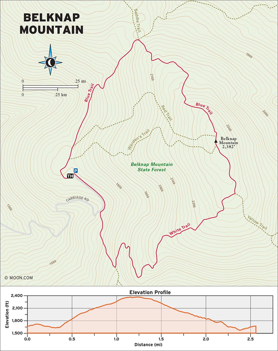
 MILE 0-0.2: Carriage Road to Blue Trail
Begin the hike in the parking lot at the top of Carriage Road. Walk toward the trailhead sign at the north end of the lot and climb a set of stone stairs (known as “Wayne’s Way” and marked with a sign) to reach a small clearing that overlooks the eastern flank of Belknap. Turn right into the woods, walk toward a wooden utility shed, and veer left at the shed to pick up the Blue Trail at a tree marked with double blue blazes.
 MILE 0.2-0.8: Blue Trail to Plane Crash Wreckage
Descend north into a forest of birch and beech on a well-trod dirt path lined with arranged rocks. Hop over a few streams before beginning the climb at 0.3 mile. The trail becomes rockier and ascends the west side of the mountain at a gradual grade. Stone and log staircases offer stable footing as the trail becomes muddy in places.
At 0.6 mile, the trail starts to level out before reaching a junction with the Saddle Trail. Keep right to stay on the Blue Trail and resume the ascent. Climb a steeper set of stone stairs and emerge into a sloped, sunny meadow with tiny white starflowers. The trees start to transition from birch to pine around here, and blue cairns begin to appear on the trail. Around 0.8 mile, look for a piece of colored tape tied to a tree branch on the left. You can find the plane crash wreckage just off the trail from this point—if you don’t mind a little bushwhacking.
 MILE 0.8-1.1: Plane Crash Wreckage to Belknap Mountain Summit
Continue northeast for 0.3 mile into an airier boreal forest before arriving at the summit of Belknap Mountain at 1.1 miles.
A fire tower looms at the summit, and while it’s safe to climb—and the glorious view of the Lakes District from the top is worth it—be aware that the staircases are quite steep, and the railings are low. Exercise caution on the up-and-down.
 MILE 1.1-1.3: Belknap Mountain Summit to Yellow/White Trail
To begin the return journey, pick up the Yellow/White Trail (marked with yellow and white blazes, naturally) on the east side of the tower and walk along the power lines that run across the ridge of Belknap before descending into a mossier swath of forest.
 MILE 1.3-1.6: Yellow/White Trail to White Trail
At 1.3 miles, reach a rocky clearing and turn right onto the White Trail as it heads south across an exposed ridge with cairns. Follow white blazes down into the woods and mind your footing on the numerous slippery rock slabs.
Descend a ramp-like stone ledge at around 1.6 miles with a killer view of Winnipesaukee, then continue south down a larger rock face.
 MILE 2.0-2.5: White Trail to Three-Way Junction and Carriage Road
At 2.0 miles, you’ll reach a three-way junction; take a right and enjoy the final stretch of the trail as it winds through deciduous beech and delivers you back to the carriage road at 2.3 miles. Turn right and walk up the carriage road to the parking lot to finish the loop at roughly 2.5 miles.
From Concord, drive north on NH-106 N for 20 miles. Merge right onto the ramp for NH-11 E/US-3 N/Laconia-Gilford Bypass and then take the NH-11A exit toward Gilford/Laconia. Turn right onto NH-11A and continue northwest for just over a mile before making a right onto Hoyt Road. Drive south for another 2 miles as Hoyt Road merges with Belknap Mountain Road. Make a final left onto Carriage Road and watch your speed as the road transitions to dirt, enters the forest, and climbs the eastern slope of Belknap. The road is narrow, winding, and steep, with several bridge crossings. As you reach the end of Carriage Road, the trail parking lot will be on your left.
GPS COORDINATES: 43°30'55.8"N 71°22'36.9"W, 43.515503, -71.376929
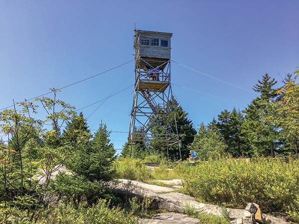
FIRE TOWER ON BELKNAP MOUNTAIN
MOUNT SUNAPEE STATE PARK, NEWBURY

Hike through the secluded woods on the north slopes of Mount Sunapee to a beautiful lake that lies just below the summit.
DISTANCE: 3.8 miles round-trip
DURATION: 2 hours
ELEVATION CHANGE: 948 feet
EFFORT: Easy/moderate
TRAIL: Dirt path, rocks, wooden bog bridges
USERS: Hikers, leashed dogs
SEASON: June-October
FEES/PASSES: $5 day-use fee per adult
MAPS: Mount Sunapee Resort website
CONTACT: Mount Sunapee State Park, 603/763-5561, www.nhstateparks.org
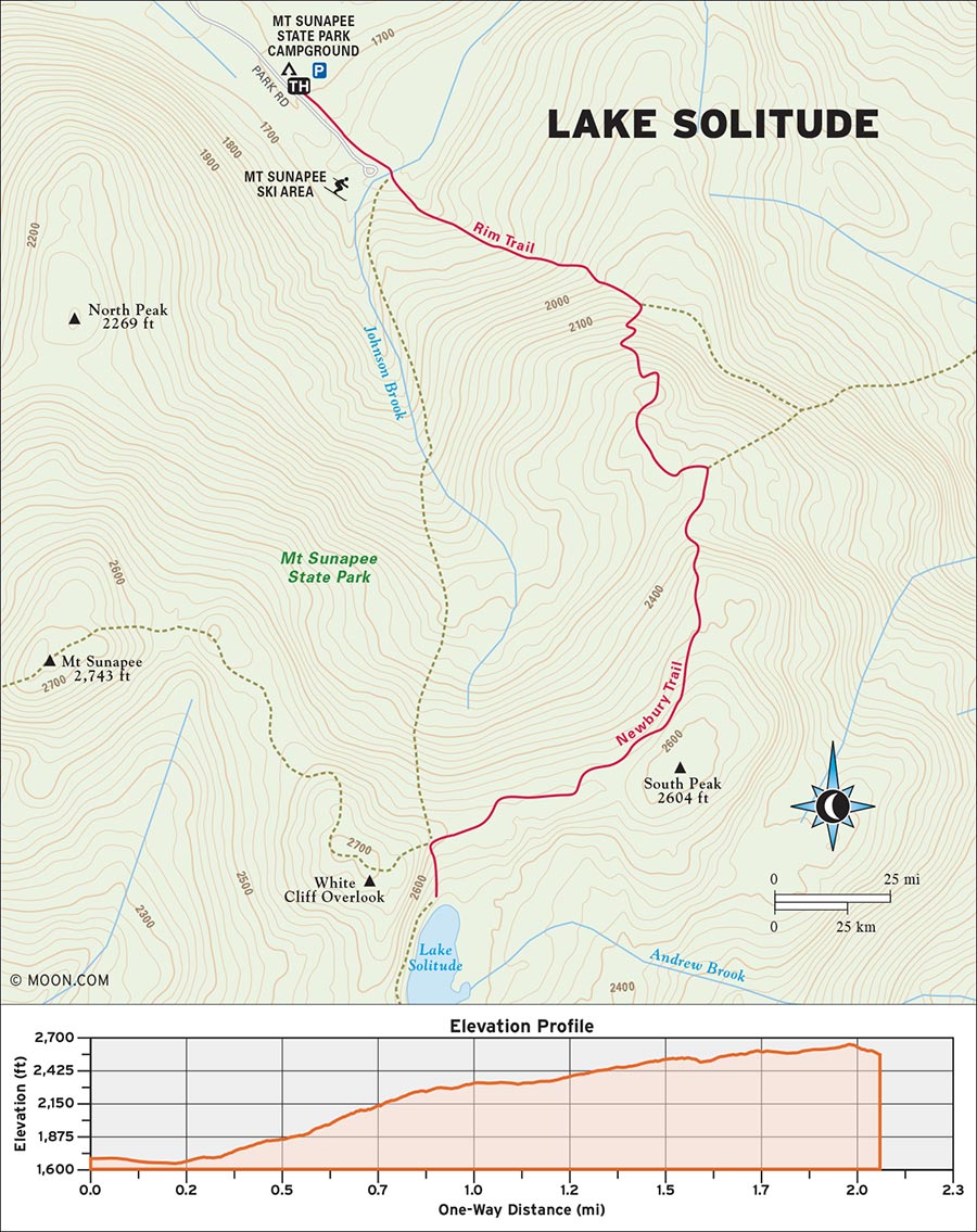
 MILE 0-0.7: Park Road to Rim Trail
Begin the hike at the end of Park Road in a clearing festooned with pieces of old ski lift machinery. Pick up the Rim Trail at the trail sign on the edge of the forest and follow yellow blazes into the woods heading southeast. Rock-hop across Johnson Brook and climb a series of gently graded stone steps through the beech trees. The stone stairs are older and some of them might be a bit loose. Listen to the chattering of red squirrels and gray jays in the branches overhead.
 MILE 0.7-1.0: Rim Trail to Newbury Trail
The trail levels off a bit before reaching a junction with Newbury Trail at 0.8 mile; make a right onto Newbury Trail (marked by orange blazes) and climb south up a steep and eroded stretch that quickly delivers you to an exposed rocky ledge called Eagle’s Nest Outlook, which has a stunning view out to Lake Sunapee. From here, the trail ascends the north side of Sunapee for a little while before flattening at roughly 1 mile and peacefully weaving through an unusually lush ridge forest that’s bursting with ferns and wildflowers.
 MILE 1.0-1.8: Newbury Trail to Jack and June Junction
The footing gets rockier and rootier as the trail goes up and down some knolls before reaching the four-way “Jack and June Junction” at 1.8 miles. Here, you can choose between a waterside view of the lake or an overhead vista.
 MILE 1.8-1.9: Jack and June Junction to Lake Solitude
For the former, turn left onto the Mount Sunapee Greenway South and descend a rocky trail for 0.1 mile that cuts through deciduous woods before arriving quite suddenly on the northern banks of Lake Solitude. Stop here or continue south on the trail for a little while as it follows the western shore of the lake.
 MILE 1.9-3.8: Lake Solitude to White Cliff Overlook
To reach the overhead vista, backtrack to Jack and June Junction and take the Mount Sunapee Greenway North up a comparably rocky trail for 0.2 to reach White Cliff Overlook—a shelf-like ledge perched just above the lake. If you still have some gas in the tank, you can continue up the Mount Sunapee Greenway North to the summit of Mount Sunapee itself, roughly 0.8 mile up the trail. Otherwise, return the way you came.
From Concord, take I-93 S briefly and merge onto I-89 N toward Lebanon/White River Junction VT. Drive northeast for 20 miles and then take Exit 9 for NH-103 toward Warner/Bradford. Follow this local highway for another 16 miles to reach the entrance to Mount Sunapee Resort. Upon reaching the entrance, turn left onto NH-103B S and continue straight onto Sunapee Road to enter the resort itself. Shortly ahead, make a left turn onto Park Road, a rugged dirt road that climbs the north slopes of the mountain. Follow the road for about a mile and you’ll reach the entrance to Mount Sunapee State Park Campground on your left. Park on the right side of the road here, across from the campground entrance. Continue on foot beyond the gate to the end of Park Road.
GPS COORDINATES: 43°19'27.4"N 72°03'53.2"W, 43.324290, -72.064774
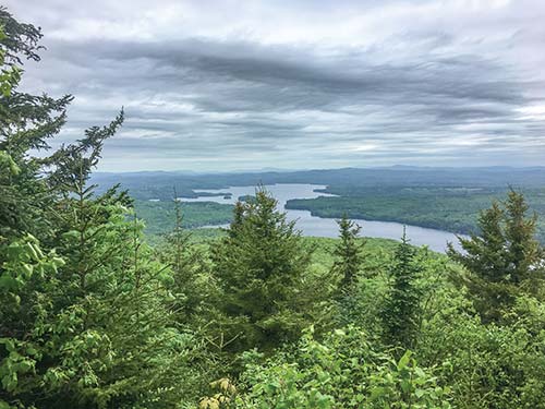
THE EAGLE’S NEST OUTLOOK
PRIVATE LAND, ALTON

This spooky, little-known hike visits a desolate mountaintop with a cave that’s rumored to be haunted by a monstrous presence.
BEST: New England oddities
DISTANCE: 5.4 miles round-trip
DURATION: 2.5 hours
ELEVATION CHANGE: 478 feet
EFFORT: Easy/Moderate
TRAIL: Dirt path, rocks
USERS: Hikers
SEASON: May-October
MAPS: USGS Strafford County Topo Map
CONTACT: LandVest Inc., 603/227-2414, www.landvest.com
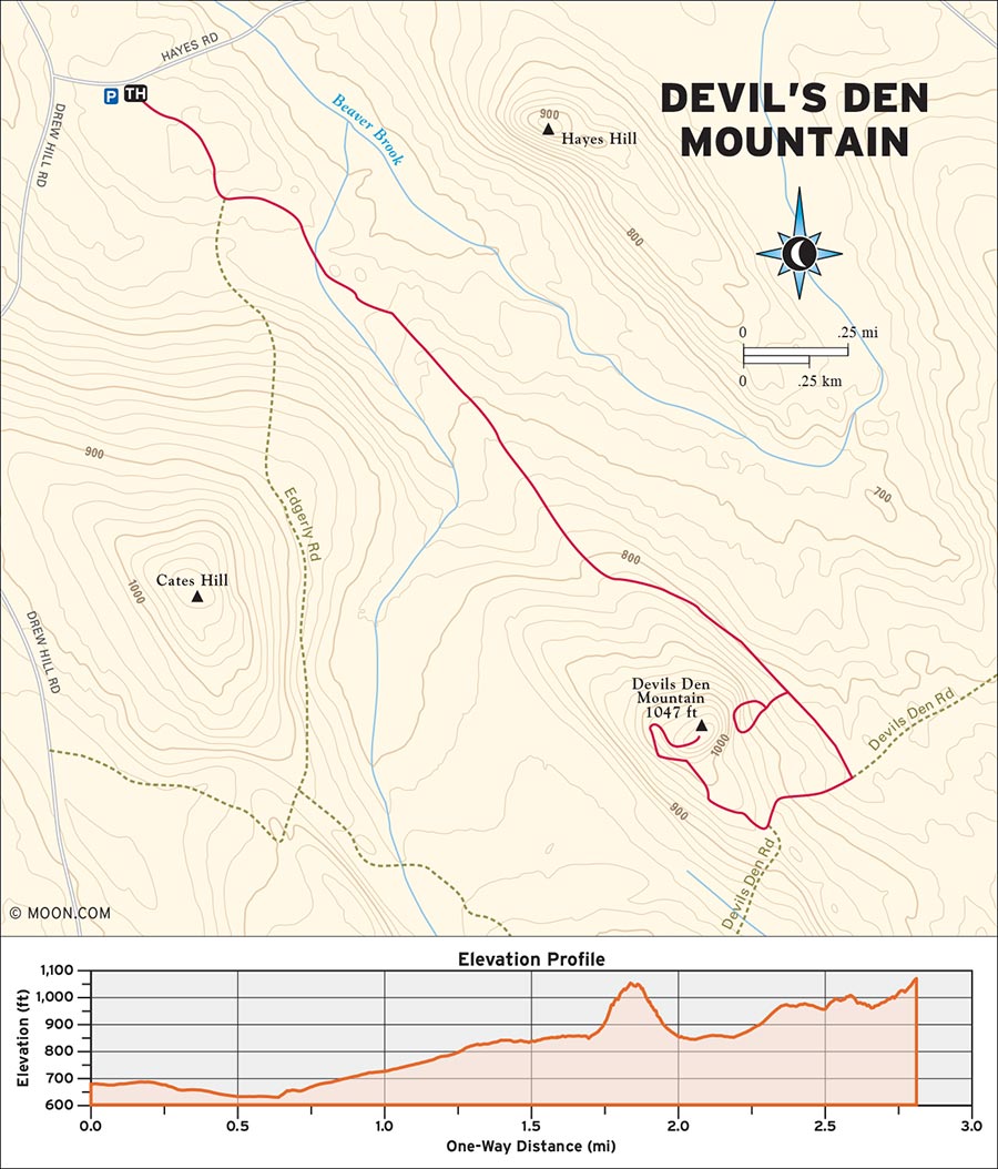
Hidden in a relatively quiet corner of the Lakes District and rising 1,050 feet above sea level, the craggy Devil’s Den Mountain offers a killer view of Lake Winnipesaukee—but its moody atmosphere is what makes it unique. The trail to the mountaintop, while easy to follow, is mostly unmarked, and the mountain’s most infamous feature—a slit cave from which locals have reported hearing ferocious hissing sounds—requires a bit of hunting around the summit area.
 MILE 0-1.3: Dirt Access Road to T-Intersection
Begin your hike by picking up the dirt access road just beyond the gate and heading southeast into the forest. This road will be your trail for most of the hike. Walk along the road as it cuts southeast through a forest of pine, birches, and stone walls. At 0.3 mile, take a left at the fork and continue onward as the road ascends at a very gentle grade. The pine trees here are green and numerous enough to make you feel like you’ve stepped into an episode of Twin Peaks.
As the road becomes sandier, you can often glimpse fresh animal tracks cutting across the ground. At 0.7 mile, keep straight at the split and hike past a clearing full of young trees. Look out for a partial glimpse of the Devil’s Den Mountain summit just ahead, around 0.9 mile. Continue hiking southeast for another 0.4 mile before reaching a T-intersection at 1.3 miles; take a left and start to climb the northwest haunch of Devil’s Den Mountain. Look to your right and you’ll glimpse a series of granite cliffs and boulders in the woods. This is where the infamous haunted cave is located.
 MILE1.3-1.8: T-Intersection to Devil’s Den Mountain Cave
To find the cave, keep an eye peeled for a rough-hewn and slightly overgrown side path that appears on your right at roughly 1.7 miles (marked with felled tree trunks). Continue for roughly 0.1 mile to reach the cliffs, then look for a red arrow spray-painted on a jumble of boulders. Scramble up the jumble and you’ll find the opening to the cave on a ledge that overlooks the forest. The interior of the cave is damp and tight—and then there are the accounts of hissing and a large shadow moving on the walls. So, proceed at your own risk.
 MILE 1.8-2.7: Devil’s Den Mountain Cave to Devil’s Den Mountain Summit
Backtrack to the road and continue southeast for another 0.3 mile before taking a right and climbing the mountain at a steeper grade. At. 2.3 miles, you’ll reach the height of land; pick up a well-tread side trail into the woods here and look for red blazes on the trees henceforth. The rocky “tower” of the summit looms ahead as the trail cuts around the south side of the summit on a series of ledges before curving to the right. Ascend a brief series of granite slabs and arrive at the top of Devil’s Den Mountain at 2.7 miles. Enjoy the lake views before returning the way you came.
From Boston, take I-93 N to Exit 37A and merge onto I-95 N toward Peabody. Drive east for 8 miles and keep right at the fork to stay on I-95 N toward Portsmouth, New Hampshire. Continue north into New Hampshire and then take Exit 4 to merge onto NH-16 N toward the White Mountains. Drive along NH-16 N for roughly 16 miles before taking Exit 15 for NH-11 W toward Farmington/Alton. Keep driving northwest until you reach downtown Alton and then merge right onto NH-28 N. Drive north on NH-28 N for a few minutes, turn right onto Drew Hill Road, and then turn left onto Hayes Road. The gated road for Devil’s Den Mountain will be on your immediate right. Open the gate and park in any of the small clearings on either side of the road just after the gate. Do not park on the road itself—it must remain clear for emergency vehicles.
GPS COORDINATES: 43°31'45.9"N 71°11'38.8"W, 43.529415, -71.194104
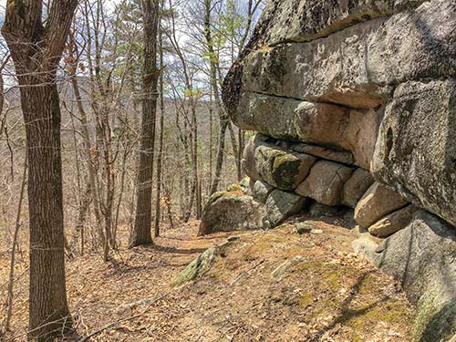
THE SUMMIT OF DEVIL’S DEN MOUNTAIN
ARMSTRONG NATURAL AREA, HOLDERNESS

This family-friendly mountain hike visits two neighboring peaks with views of Squam Lake that would make Ansel Adams weep.
DISTANCE: 3.8 miles round-trip
DURATION: 2 hours
ELEVATION CHANGE: 609 feet
EFFORT: Easy/moderate
TRAIL: Dirt path, rocks
USERS: Hikers, leashed dogs
SEASON: June-October
FEES/PASSES: None
MAPS: New Hampshire Division of Forests and Lands website
CONTACT: New Hampshire Natural Heritage Bureau, 603/271-2215, www.nhdfl.org
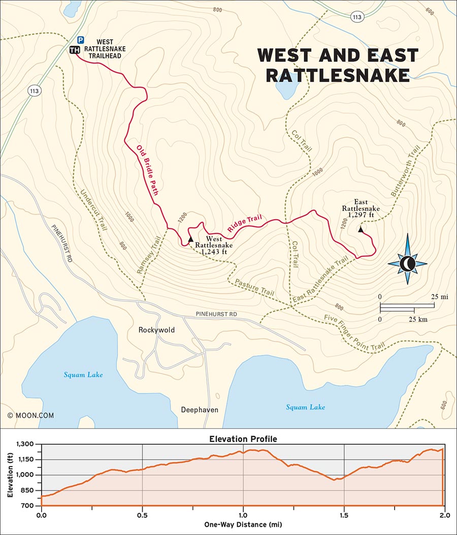
Rising from the northern shores of Squam Lake, the modest West and East Rattlesnake Mountains form a popular destination for families with small children and couples making proposals. A gentle ascent up West Rattlesnake leads to a vast, heavily visited lookout ledge with one of the most awe-inducing panoramic lake views anywhere in New England. The neighboring East Rattlesnake is more quiet and rugged, but it features a comparably beautiful vista with a more romantic ambience.
 MILE 0-0.4: Trail Information Kiosk to Old Bridle Path
Begin the hike in the south end of the parking lot, where you’ll see a wooden trail information kiosk. Pick up the Old Bridle Path by the kiosk and head southeast up log stairs into the forest. The trail is wide and mostly dirt, with a few odd rocks scattered about. Follow yellow diamond markers on the trees as the trail flows through oaks and beech, gradually curving south and ascending some gently sloped rock slabs near the entrance to a University of New Hampshire revegetation area at 0.4 mile (UNH manages portions of the land here).
 MILE 0.4-0.9: Old Bridle Path to West Rattlesnake Lookout
Climbing steadily up the western flank of West Rattlesnake, the trail passes into an airy stretch of red pines, where the terrain alternates between flat stony floor and rock stairs. Glimpses of blue through the trees hint at the nearby lookout. At 0.8 mile, turn left at the junction with the Ramsey Trail to stay on Old Bridle. Ascend a series of exposed and sloping rock faces to reach another set of log stairs that delivers you to the scenic West Rattlesnake lookout at 0.9 mile. The rock here has a deep glowing tan that’s reminiscent of landscapes in the American Southwest, and the view is spectacular. The lookout ledge is generally a bit crowded.
 MILE 0.9-1.5: West Rattlesnake Lookout to Ridge Trail
To continue onward to more peaceful surroundings, pick up the Ridge Trail by the junction sign on the ledge and head northeast back into the woods, where you’ll quickly reach the wooded summit of West Rattlesnake at 1 mile. The narrower dirt trail, marked by green diamond markers, plows through a breezy ridge forest before making a steeper descent into a much darker forest in the col (gap) between the two mountains. A rugged climb out of the col brings you to the junction with the aptly named Col Trail at 1.4 miles. Turn left here, and then take an immediate right at a second junction ahead to stay on the Ridge Trail.
 MILE 1.5-1.7: Ridge Trail to East Rattlesnake Trail
Climb northeast along the sunnier southern slopes of East Rattlesnake for another 0.3 mile. Watch your step on the countless exposed roots along this stretch of trail, which can become quite eroded during drier summer conditions. At 1.7 miles, you’ll reach the junction for East Rattlesnake Trail; veer left to take East Rattlesnake and continue along a narrow ledge-like path.
 MILE 1.7-3.8: East Rattlesnake Trail to East Rattlesnake Lookout
Climb steadily up the mountain before reaching the gorgeous East Rattlesnake lookout at 1.8 miles. The lookout ledge is perfectly framed by trees that have bent to form a circular opening in the woods. (The intimate scale of this ledge, paired with the beauty of Squam Lake, would make this a fine place to propose.) The wooded summit of East Rattlesnake is 0.1 mile farther up the trail, which continues north from the ledge into the woods. Top off the summit and then return the way you came.
From Concord, drive north on I-93 N for 36 miles and take Exit 24 for US-3/NH-25 toward Ashland/Holderness. At the bottom of the off-ramp, turn right onto NH-25 E/US-3 S and continue along this road for 4 miles. As you enter downtown Holderness, pull a left onto NH-113 and drive northeast and then north for another 5 miles. The Rattlesnake parking lot will be on your right at the top of a hill.
GPS COORDINATES: 43°47'19.8"N 71°32'54.3"W, 43.788831, -71.548407
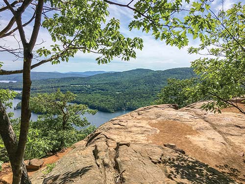
THE VISTA FROM WEST RATTLESNAKE
MARKUS WILDLIFE SANCTUARY, MOULTONBOROUGH

This wildlife-rich hike takes hikers through a lush forest, wetlands, and along the shores of Lake Winnipesaukee to visit an active loon nest.
BEST: Spring hikes
DISTANCE: 2 miles round-trip
DURATION: 1 hour
ELEVATION CHANGE: 75 feet
EFFORT: Easy
TRAIL: Dirt path, rocks, wooden bridges
USERS: Hikers
SEASON: May-October
FEES/PASSES: None
MAPS: Loon Preservation Committee website
CONTACT: Loon Preservation Committee, 603/476-5666, www.loon.org/markus-wls.php
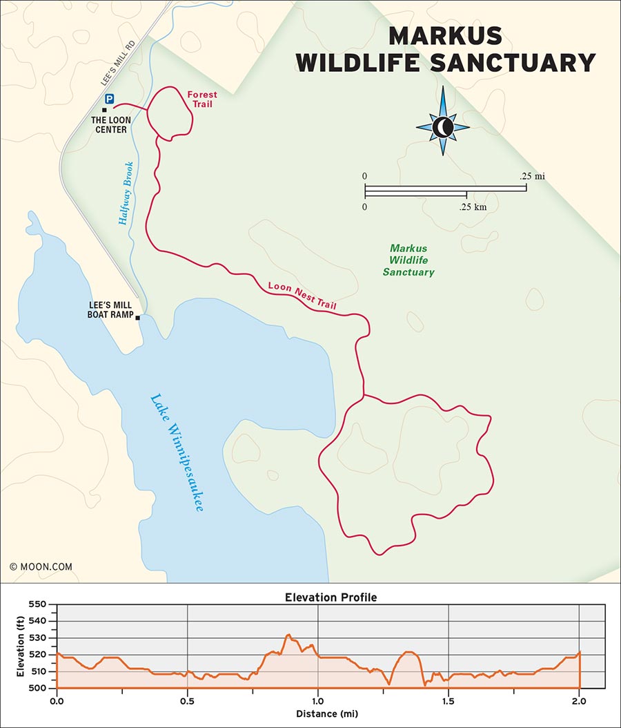
Countless mammal, bird, and reptile species reside along the waterfront woodlands in the Lakes District. The Markus Wildlife Sanctuary is a lush preserve that offers hiking trails through the conjoined ecosystems of Lake Winnipesaukee. The “crown jewel” of the sanctuary is the loon nest, a special place that draws native loons each year. Midsummer is the best season to hear their distinct cry.
 MILE 0-0.2: Loon Center to Forest Loop Trail
Begin your hike in the parking lot by the Loon Center building. Find the Trails sign and walk east, toward a large wooden bridge that spans a brook. Cross the bridge into the woods, pick up the Loon’s Nest Trail for a few yards, and then take an immediate left onto the Forest Trail Loop. Stroll through a corridor of pine trees marked with red blazes and keep an ear open for birdsong.
 MILE 0.2-0.5: Forest Loop Trail to Loon’s Nest Trail
Upon reaching the end of the Forest Trail Loop, turn left back onto Loon’s Nest Trail, following yellow blazes along a smooth dirt path that weaves through the woods along the brook. At 0.3 mile, cross a second wooden footbridge as the trail curves away from the brook. Continue along some sections of wooden boardwalk through a wetter area of the forest and enjoy a few glimpses of Lake Winnipesaukee between the trees. The trail passes through a patch of bogland, becoming rockier with each yard, before entering a darker forest of pine.
 MILE 0.5-1.2: Loon’s Nest Trail to Loon’s Nest Trail Loop and Lookout Point
After crossing a stream on rocks, you’ll reach a trail junction at 0.7 mile; the Loon’s Nest Trail diverges in two directions to form a loop. Make a left and note how intensely green the forest becomes. The abundance of moss here feels more like the Pacific Northwest. As the path rolls up and down mildly through the woods, you’ll really hear the melodies of native bird species. At 1.1 miles, emerge from the forest by a marsh and hike northwest along the banks of the lake until you reach a bench at 1.2 miles. This is the lookout point for the loon nest.
 MILE 1.2-2.0: Lookout Point to Boardwalk
Take a seat, watch the reeds of the marsh for rustling, and listen for that unmistakable cry that the White Mountains are famous for. From the lookout, the trail turns back into the woods, passing some muddier terrain before arriving at a massive glacial rock formation that hikers must squeeze their way through. The trees around here are often speckled with wild discus-shaped mushrooms that grow on the bark and can become quite large. Continue along the rocky, rooty path for another 0.2 mile before reaching the end of the Loons Nest Trail loop at 1.4 miles. Turn left and backtrack over the boardwalk and along the brook to return to the trailhead and end your hike at 2 miles.
From Concord, drive north on I-93 N for 30 miles and take Exit 23 for NH-104/NH-132 toward Meredith/New Hampton. Turn right onto NH-104 E/NH-132 N at the bottom of the off-ramp and drive east for 8 miles. Veer right onto US-3 N and then make another right onto NH-25 E/Winnipesaukee Street. Take this road northeast for another 9 miles before turning right onto Blake Road. Follow the road to its terminus and then turn right onto Lee’s Mill Road. The Loon Center visitors building and parking area will be on your left shortly after this turn.
GPS COORDINATES: 43°44'15.2"N 71°23'27.1"W, 43.737557, -71.390856
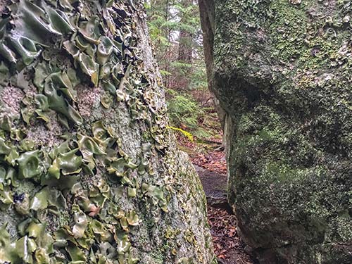
THE NARROW ROCK CORRIDOR NEAR THE LOON’S NEST
WHITE MOUNTAIN NATIONAL FOREST, THORNTON

This two-in-one mountain hike has plenty of broad and exposed slabs that offer sweeping views of the Waterville Valley.
DISTANCE: 4.2 miles round-trip
DURATION: 3 hours
ELEVATION CHANGE: 1,711 feet
EFFORT: Moderate/strenuous
TRAIL: Dirt path, rocks, water crossings on stones
USERS: Hikers, leashed dogs
SEASON: June-October
FEES/PASSES: $5 day-use fee per vehicle
MAPS: White Mountain National Forest website
CONTACT: White Mountain National Forest, 603/536-6100, www.fs.usda.gov/main/whitemountain
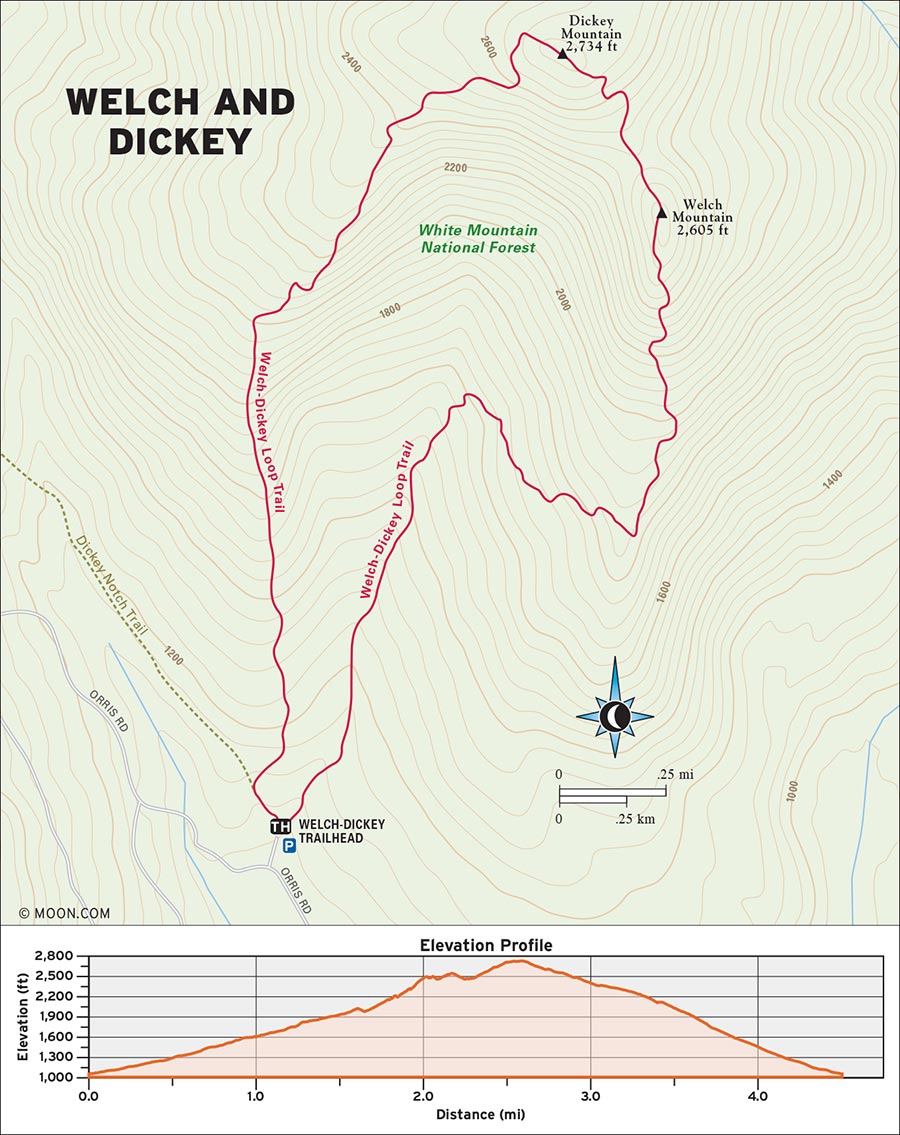
Plopped on the northern border of the Lakes District, the conjoined Welch and Dickey Mountains are well known for their steep and mostly treeless rock faces.
 MILE 0-1.1: Trail Information Kiosk to Welch-Dickey Loop Trail
Begin the hike in the north end of the parking lot by the trail information kiosk. Pick up the stony Welch-Dickey Loop Trail, marked by yellow blazes, and veer right at the first fork. The trail kicks off on a root-festooned note, gradually climbing Welch Mountain through a hemlock forest. Cross a brook on rocks at 0.2 mile. As the grade steepens, the spacious path transitions to a rotating series of log and rock stairs that lead to a darker boreal forest with some exposed slabby sections—a small taste of what’s ahead.
 MILE 1.1-2.0: Welch-Dickey Loop Trail to Welch Mountain Summit
Quite suddenly, at around 1.2 miles, the trail emerges onto a wide and exposed clearing with nice views toward Sachem and Jennings Peaks. The tundra here is protected with felled tree trunks that have been placed as natural barriers. The trail continues north up some sparsely wooded rock slabs on the southern side of Welch before reaching a vaster, steeper, and more exposed rock face at 1.5 miles. Now the climb begins. Scramble your way up the epic rock face and hoist yourself up some boulders to reach the summit of Welch Mountain at 2 miles. Look out to see the pinnacle of the larger Dickey Mountain directly ahead.
 MILE 2.0-2.4: Welch Mountain Summit to Dickey Mountain Summit
Continue on the trail to descend into the col (gap) between the two mountains. At the bottom of the col, pass by an enormous cairn at 2.1 miles and make a brief foray back into boreal woods before scaling an even steeper and more exposed section of slabby rock faces. At 2.4 miles, step onto the summit of Dickey Mountain, where you can savor a view of the deep green Pemigewasset Wilderness to the north.
 MILE 2.4-4.2: Dickey Mountain Summit to Dickey Notch Trail
As you begin your descent of the mountain’s southern haunch, get ready for the best part yet—a long walk down a barren rock shelf with a sheer drop on one side, and killer views of Welch. This shelf is a great place to appreciate the grandeur of the Whites. The smooth rock here can get slippery in wet weather.
As you near the end of the shelf descent, segue back into deciduous forest at 3.3 miles. The trail narrows considerably and heads south, descending the remainder of Dickey by way of winding rock stairs and a dirt path that’s somewhat eroded in places from heavy hiker traffic. The grade is consistently moderate, with only a few steeper pitches. Swing left at the Dickey Notch Trail junction at 4.1 miles to stay on the Welch-Dickey Loop Trail and amble through the forest to meet back up with the loop trailhead fork and parking lot at 4.2 miles.
From Concord, drive north on I-93 N for 48 miles and take Exit 28 toward NH-175/Campton/Waterville Valley. At the end of the off-ramp, turn right onto NH-49 E and continue northeast for another 5 miles before making a left turn onto Upper Mad River Road. Head west along this road for half a mile and pull a final right onto Orris Road. The Welch and Dickey trailhead parking lot is another half mile ahead on your right.
GPS COORDINATES: 43°54'14.8"N 71°35'19.9"W, 43.904116, -71.588864
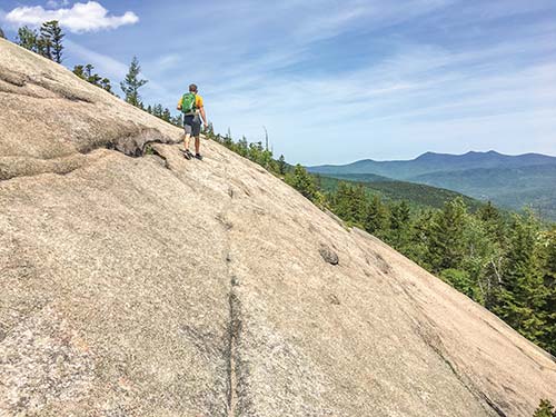
THE EXPOSED FACE OF UPPER WELCH
WELTON FALLS STATE FOREST, ALEXANDRIA

Follow a pretty brook through the forest to a cascade that spills from a rift in the cliffs.
DISTANCE: 2.6 miles round-trip
DURATION: 2 hours
ELEVATION CHANGE: 472 feet
EFFORT: Easy
TRAIL: Dirt path, water crossings via stones
USERS: Hikers, leashed dogs
SEASON: May-October
FEES: None
MAPS: Appalachian Mountain Club Southern New Hampshire Trail Map
CONTACT: Appalachian Mountain Club Cardigan Lodge, 603/744-8011, www.outdoors.org
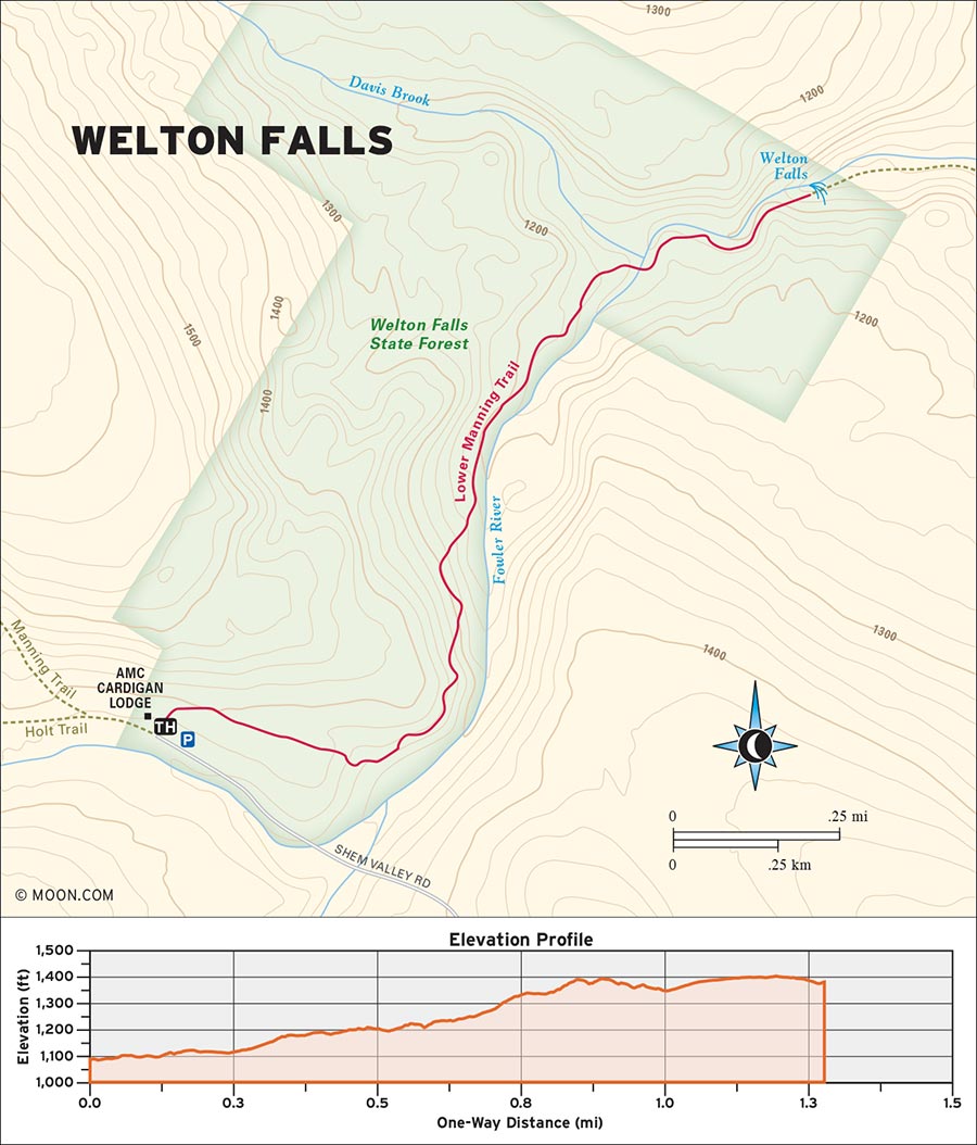
 MILE 0-0.3: Shem Valley Road to Manning Trail
Begin the hike from the shoulder of Shem Valley Road; look for the wooden sign for Lower Manning Trail and walk east into a hemlock forest past several tent sites and a pair of outhouses. Yellow blazes mark the way as the path crosses a ski trail and descends a series of log stairs into the forest. Rock-hop your way across a chuckling stream and listen for the roar of Clark Brook as the air suddenly becomes much cooler and moist.
 MILE 0.3-1.0: Manning Trail to Clark Brook
At 0.3 mile, the trail reaches the first viewpoint of the brook and then turns sharply to the north. Make your way down a few more sets of log and stone stairs and enjoy a more agreeable grade as you follow Clark Brook, which flows north alongside the trail. Watch your footing on several more stream crossings—some of them quite muddy—and take a moment to admire the brook from a few more outlook points. After a brief, higher climb above the brook, the trail descends and crosses Clark Brook on rocks at 1 mile. Be sure to exercise caution crossing here, especially during the late spring when snowmelt can cause the water level to rise. Look for a double yellow blaze on a tree on the opposite side of the brook to stay along the trail.
 MILE 1.0-1.3: Clark Brook to Welton Falls
Continue hiking north as the trail veers deeper into the woods and starts to scramble up a steeper series of knolls with lots of exposed tree roots. Crest a height of land and mind your footing as the trail suddenly makes a steep, winding descent and arrives at the top of Welton Falls at 1.3 miles For a unique perspective of the 30-foot-tall cascade, take the marked viewpoint path onto a ledge that wraps around a large cliff to an overlook where you can view the falls from above. An old cable fence offers some measure of protection from the drop, but it’s best not to test its limits.
 MILE 1.3-2.6: Welton Falls to Lower Manning Trail
To reach the bottom of the falls, continue down the Lower Manning Trail as it wraps around the rim of a ravine before making a final descent. While descending, you’ll get multiple viewpoints of the falls, which pour from a little slot in the cliffs into the ravine that you just bypassed. The actual base of the falls can be tricky to reach—the swimming holes that lie just beyond the base of the falls are far more popular. Return the way you came after taking a refreshing dip.
From Concord, drive north on I-93 N for 30 miles and take Exit 23 for NH-104/NH-132 toward Meredith/New Hampton. Turn left onto NH-104/NH-132 and drive west into Bristol. Continue straight onto Lake Street and then veer left onto Bristol Hill Road. Drive northwest and make another left onto Plumer Hill Road. Swing a left onto Thissell Road, then turn right onto Town Pound Road. Keep right at the fork with Washburn Road and continue heading northwest as Town Pound Road becomes Mount Cardigan Road. After 3 miles, turn right to stay on Mount Cardigan Road, which becomes the dirt Shem Valley Road. (Be careful driving this road in spring—it can get muddy enough to trap low-clearance vehicles.) Continue until you arrive at the Appalachian Mountain Club’s Cardigan Lodge. Park on the left side of the road.
GPS COORDINATES: 43°38'56.7"N 71°52'35.5"W, 43.649073, -71.876534
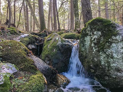
A CHUCKLING STREAM ALONG THE TRAIL
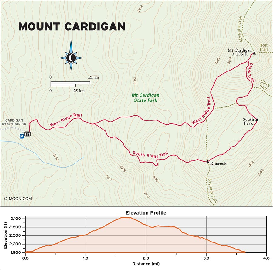
CARDIGAN MOUNTAIN STATE PARK, ORANGE

This tough but short mountain hike is a rock scrambler’s paradise—and the beautiful views into Vermont aren’t bad either.
DISTANCE: 3.4 miles round-trip
DURATION: 3 hours
ELEVATION CHANGE: 1,191 feet
EFFORT: Moderate/strenuous
TRAIL: Dirt path, rocks, wooden bridges, water crossings on stones
USERS: Hikers, leashed dogs
SEASON: June-October
FEES/PASSES: None
MAPS: Cardigan Mountain State Park website
CONTACT: Cardigan Mountain State Park, 603/227-8745, www.nhstateparks.org
In the 1950s, a devastating forest fire ripped across western New Hampshire. The blaze was so strong that it left some mountains stripped of vegetation at their highest points, including Mount Cardigan. The boreal forest has grown back, but the upper cone of the mountain is still a steep, treeless heap of granite. This makes for an exhilarating climb to the top, with panoramic vistas of the surrounding wilderness and plenty of smooth rock slabs to be scaled.
 MILE 0-0.4: Mount Cardigan Trail Information Sign to West Ridge Trail
Begin the hike on the east side of the parking lot by the wooden trail information sign. Climb a set of log stairs into the woods and head northwest up West Ridge Trail, marked by orange blazes. The trail begins as a well-worn stone path that snakes through the spruce and birch trees on Cardigan’s western slopes. Step carefully on the abundant tree roots that squiggle across the trail and look out for some prized plant species such as lady’s slippers. Cross a winding stream on rocks before reaching a junction with South Ridge Trail at 0.4 mile; keep left to stay on West Ridge Trail.
 MILE 0.4-1.4: West Ridge Trail to Cardigan Mountain Summit Dome
Continuing northwest up the mountain, the trail becomes rockier and steeper as the surrounding woods transition into a more boreal collection of trees. Craggy rocks and boulders around the trail foreshadow what awaits. A brief and more level reprieve from the climb leads to a wooden bridge at 0.8 mile.
From here, the ascent resumes at a steep grade almost immediately and ascends sloped slabs and rock stairs to the Skyland Trail junction at 1 mile. Make a left turn to stay on West Ridge and keep left again at the Ranger Cabin Trail junction shortly ahead. Then, quite suddenly, emerge from the woods at 1.4 miles onto the massive and exposed summit dome of Cardigan Mountain.
 MILE 1.4-1.6: Cardigan Mountain Summit Dome to Cardigan Mountain Summit
The home stretch of the West Ridge Trail is a thrilling climb straight up the barren granite slopes of Cardigan’s summit. Follow the cairns and watch out for algae on the rock during wet weather. Be sure to take a look behind you and gaze out toward White River Junction, Mount Killington, and Camel’s Hump in nearby Vermont. Climb a final and less sheer pitch of stone before reaching the victory point at 1.6 miles—the summit of Cardigan Mountain. Scale the fire tower and look to the east to see the mighty Presidentials looming like a gathering of green giants. Just northeast of Cardigan’s summit lies The Firescrew—a partially wooded ridge where the fire that ravaged Cardigan in the 1800s left a spiral-shaped section of exposed rock amid the trees.
 MILE 1.6-2.3: Cardigan Mountain Summit to South Ridge Trail
Once you’re ready to head back, pick up the Clark Trail by following cairns that head south from the summit to the junction with South Ridge Trail at 1.7 miles. Turn right here to pick up the South Ridge Trail and descend an even steeper side of the exposed dome. (Scrambling on your hands and knees may prove necessary.) Keep left at the fork for the old Cardigan ranger cabin and make another right at the Hurricane Gap Trail junction at 1.9 miles to stay on South Ridge. Hike across a wooded ridge to the South Cardigan summit and then down to the nearby Rimrock peak at 2.3 miles. Here you’ll reach a four-way intersection with Skyland Trail; stay straight on South Ridge and continue down into the boreal forest.
 MILE 2.3-3.4: South Ridge Trail to Mount Cardigan Trailhead
The descent continues through the mossy woods on Cardigan’s south face at an increasingly gradual grade. Hike for another 0.5 mile, crossing some streams on rocks and passing through wildflowers and berry bushes. At 3 miles, link back up with the South Ridge Trail. Make a left and backtrack to the trailhead to complete your loop at 3.4 miles.
From Concord, drive north on I-93 N for 5 miles and take Exit 17 for US-4 toward US-3/NH-132/Boscawen/Penacook. Merge onto US-4/Hoit Road and drive to the traffic circle, where you’ll take the first exit, US-4 W. At the fork ahead, make a slight left to stay on US-4 W and continue for 15 miles. Make a right turn onto US-4 and drive north for another 11 miles. Pull a right onto Turnpike Road and then a second right onto Millbrook Road. Follow this road to its terminus and then turn left onto Burnt Hill Road. Drive north for 2 more miles and make a final right turn onto Cardigan Mountain Road, which leads to the hiker parking lot and trailhead.
GPS COORDINATES: 43°38'38.9"N 71°56'06.4"W, 43.644133, -71.935104
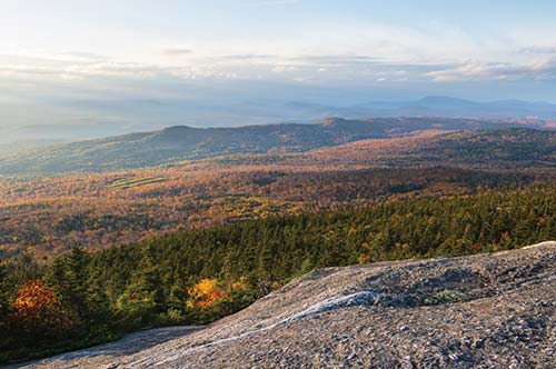
A VIEW OF THE VALLEY FROM MOUNT CARDIGAN’S BARREN SUMMIT CONE
| NEARBY CAMPGROUNDS | ||||
|---|---|---|---|---|
| NAME | LOCATION | FACILITIES | SEASON | FEE |
| AMC Cardigan Campsites | 774 Shem Valley Rd., Alexandria, NH 03222 | Tent sites, toilets, potable water | year-round | $32-62 |
| 603/744-8011, www.outdoors.org | ||||
| Mascoma Lake Campground | 92 US Route 4A, Lebanon, NH 03766 | Tent sites, RV sites, cabins, cottages, tiny houses, toilets, showers, potable water, laundry, camp store, Wi-Fi | early May through mid-October | $30-95 |
| 603/448-5076, www.mascomalake.com | ||||
| Mount Sunapee State Park | 86 Beach Access Rd., Newbury, NH 03255 | Tent sites, lean-tos, toilets, potable water | late May through mid-October | $23-29 |
| 603/763-5561, www.nhstateparks.org | ||||
| Harbor Hill Camping Area | 189 NH-25, Meredith, NH 03253 | Tent sites, RV sites, cabin tents, cabins, toilets, showers, potable water, laundry, swimming pool, camp store, Wi-Fi | late May through mid-October | $37-72 |
| 603/279-6910, www.hhcamp.com | ||||
| Baker River Campground & Resort | 56 Campground Rd., Rumney, NH 03266 | Tent sites, RV sites, toilets, showers, potable water, camp store | mid-May through mid-October | $35-42 |
| 603/786-9707, www.bakerrivercampground.com | ||||
| Long Island Bridge Campground | 29 Long Island Rd., Moulton-borough, NH 03254 | Tent sites, RV sites, toilets, showers, potable water, laundry, Wi-Fi | mid-May through mid-October | $32-50 |
| 603/253-6053, longislandbridgecampgroundnh.com | ||||
| Clearwater Campground | 556 NH-104, Meredith, NH 03253 | Tent sites, RV sites, toilets, showers, potable water, laundry, camp store, Wi-Fi | mid-May through early October | $31-184 |
| 603/279-7761, www.clearwatercampground.com | ||||
| Wolfeboro Campground | 61 Haines Hill Rd, Wolfeboro, NH 03894 | Tent sites, RV sites, toilets, showers, potable water, camp store, Wi-Fi | late May through early October | $32-35 |
| 603/569-9881, www.wolfeborocampground.com | ||||
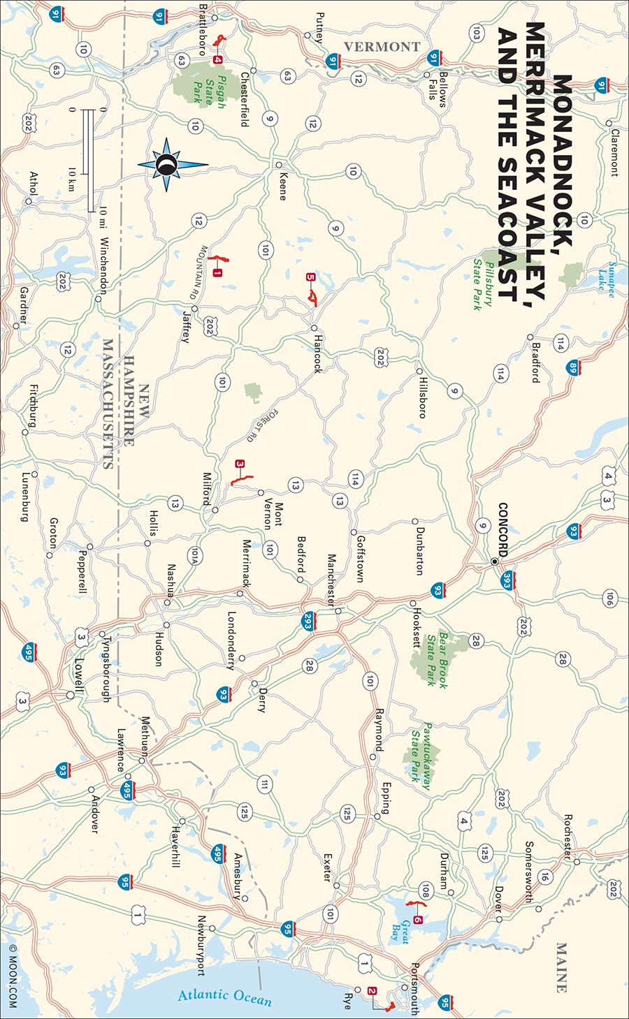
Southern New Hampshire is the delta for northern New England’s famous mountains, forests, and seacoast. Far from being just a place between Boston and popular summer destinations like the White Mountains and Acadia, the southern reaches of New Hampshire are a taster’s menu of adventures for first-time hikers and experienced backcountry trekkers. The numerous suburbs and small cities of the region are surrounded by mile after mile of sunny forests, angular hills, and coastal marshes and beaches that are often singing with visiting birds and native wildlife. In southern New Hampshire, you can saunter past a farm, over hills, and through swamps before arriving at a secluded beach. It’s just that easy.
1 Monte Rosa and Mount Monadnock
5 Skatutakee Mountain and Thumb Mountain

ODIORNE TIDEPOOLS
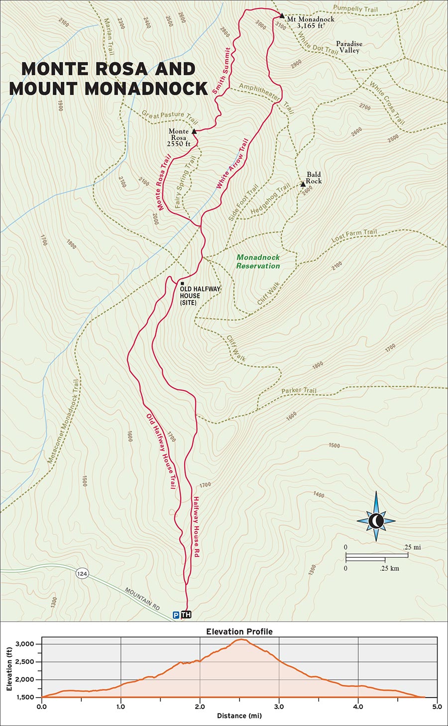
MONADNOCK STATE PARK, JAFFREY

This thrilling and under-the-radar route up America’s most climbed mountain features two summits, plenty of rock scaling, and an unbeatable view of southern New England.
DISTANCE: 4.6 miles round-trip
DURATION: 3.5 hours
ELEVATION CHANGE: 1,509 feet
EFFORT: Strenuous
TRAIL: Dirt path, rock scrambling
USERS: Hikers
SEASON: May-October
FEES/PASSES: $5 parking fee per vehicle (cash only)
MAPS: New Hampshire State Parks website
CONTACT: Monadnock State Park, 603/532-8862, www.nhstateparks.org
Like many outdoor attractions in New England, Mount Monadnock was one of Henry David Thoreau’s favorite stomping grounds. Today, it attracts more visitors per year than any other mountain in the continental United States. This leads to overcrowding and erosion on some of the most popular trails, but luckily, Monadnock features almost as many ascent routes as it does humans. And the Monte Rosa loop on the west side is the prettiest and most physically invigorating.
 MILE 0-1.2: Monadnock State Park Ranger Booth to Old Halfway House Trail
Begin your hike in the Old Toll Road parking lot by approaching the ranger booth. Just beyond the station, to the left of the toll road itself, you’ll see a sign for the Old Halfway House Trail. Turn left onto the trail and ascend north through a forest of white pine and northern hardwoods. The footing is deceptively soft and gentle here—your warm-up for the real climb ahead.
 MILE 1.2-1.3: Old Halfway House Trail to Old Halfway House Site
Amble through the woods for 1.2 miles before reaching a junction with the Cart Path. Turn right here, emerge onto the toll road, and make a left to continue up the road for another 0.2 mile to the old Halfway House site. This grassy clearing once featured a hotel for hikers, but today it offers an alluring view of Monadnock’s upper flanks and summit.
 MILE 1.3-1.6: Old Halfway House Site to Monte Rosa Trail
From the Halfway House site, pick up the White Arrow Trail and head north briefly before turning left onto the Monte Rosa Trail at 1.4 miles.
The trail steepens dramatically here, climbing straight up a torrent of roots, rocks, and loose soil. A few lush groves of wildflowers offer a contrast to the brutishness of the trail.
 MILE 1.6-1.8: Monte Rosa Trail to Monte Rosa Summit
Keep climbing for 0.2 mile past the Fairy Spring Cutoff until you reach a rocky height of land at 1.8 miles where the trees recede to shrub-like krummholz. This is the summit of Monte Rosa, marked by a weathervane on a steel post.
 MILE 1.8-2.4: Monte Rosa Summit to Mount Monadnock Summit
Once you’ve had a chance to drink in the vista here, pick up the Great Pasture Trail, make a left turn onto the Smith Summit Trail just a few yards ahead, and climb northeast up the west face of Monadnock. (Look for white S’s spray-painted on the rock.) Watch your footing on the well-worn rock slabs as you scramble upward for 0.6 mile before arriving at the summit of Mount Monadnock at 2.4 miles. Odds are you’ll have to wait in line to stand at the highest point, but the 360-degree views of Massachusetts, the Green Mountains, and New Hampshire’s Lakes District should be more than enough to satisfy.
 MILE 2.4-4.6: Mount Monadnock Summit to Old Halfway House Site
To begin your descent, briefly backtrack down the Smith Summit Trail and turn left onto the White Arrow Trail. For the next 0.4 mile, you’ll lower yourself down steep, craggy rock faces marked with white arrows before transitioning back into the woods and enjoying easier, less sheer footing. Continue through the forest as you pass the Monte Rosa Trail entrance (keep left here) and arrive back at the Old Halfway House site at 3.3 miles. Depending on your energy level, you can take the Old Halfway House Trail again or descend the final 1.3 miles by staying on the smoother old toll road itself.
From Boston, drive to Cambridge’s Alewife Station and pick up MA-2 W/Concord Turnpike. Head northwest along MA-2 for 39 miles and then merge onto MA-140 N in Westminster. Keep heading northwest as MA-140 merges with MA-12 N near Winchendon. Take a sharp right onto US-202 and continue north into New Hampshire. Once you reach the town of Jaffrey, turn left onto NH-124 W and drive west for 5 miles. The Old Toll House parking lot will be on your right.
GPS COORDINATES: 42°50'07.7"N 72°06'53.8"W, 42.835482, -72.114955
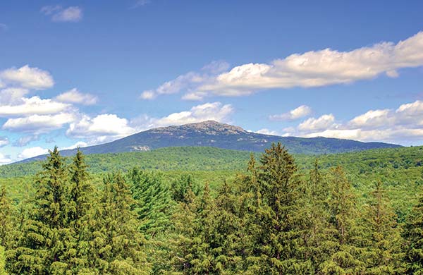
MOUNT MONADNOCK
ODIORNE POINT STATE PARK, RYE

This seaside stroll across one of New Hampshire’s finest coastal conservation areas bypasses sandy and rocky beaches, tidepools, spooky World War II-era bunkers, and a drowned forest.
DISTANCE: 3.3 miles round-trip
DURATION: 2 hours
ELEVATION CHANGE: 74 feet
EFFORT: Easy
TRAIL: Dirt path, sandy beaches, rocks, wooden bridges
USERS: Hikers
SEASON: March-November
PASSES/FEES: $4 adult, $2 child ages 6-11 (late May through October)
MAPS: Odiorne Point Seacoast Science Center website
CONTACT: Odiorne Point State Park, 603/436-7406, www.nhstateparks.org
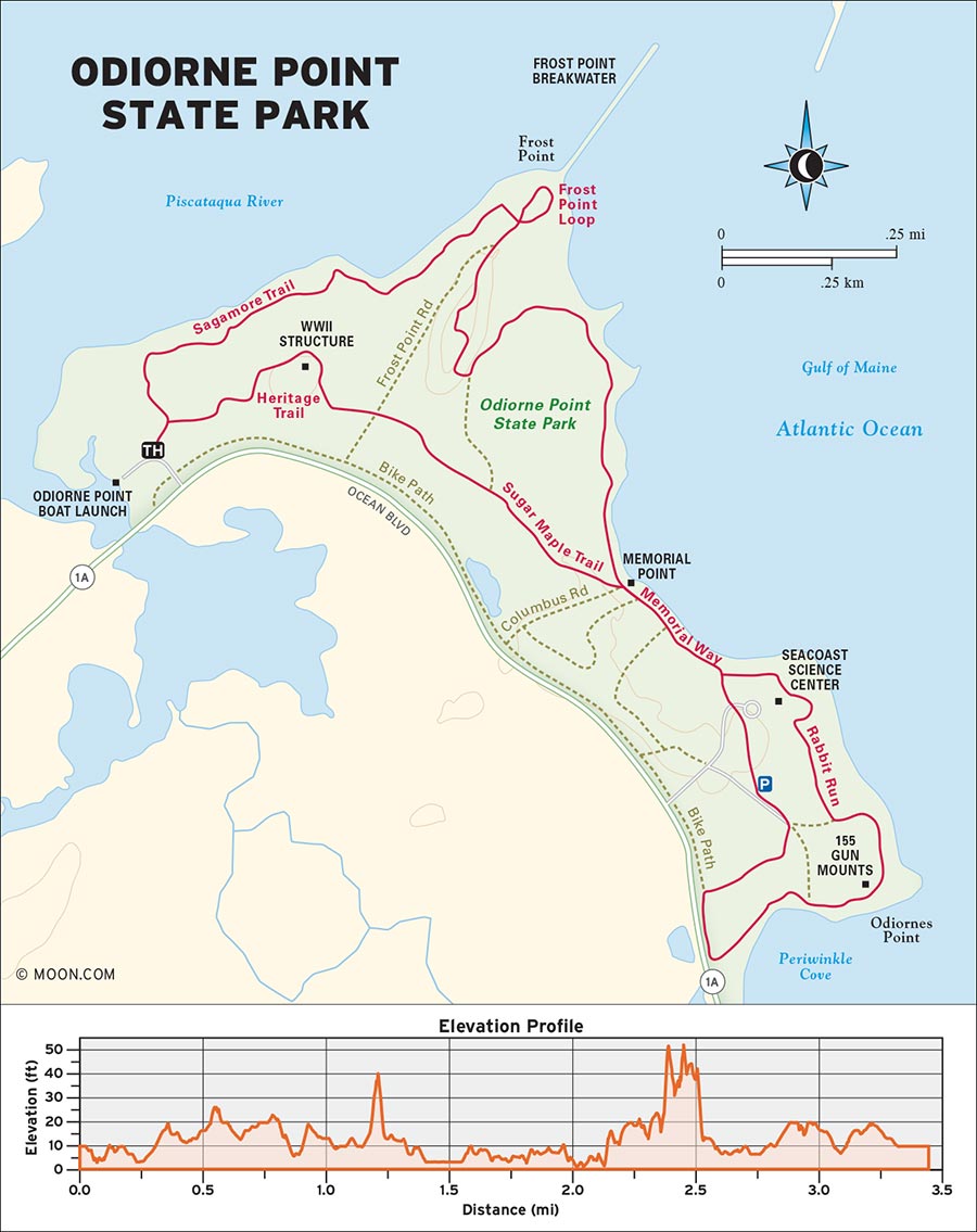
Roughly 30 minutes north of the casinos and clam shacks that occupy Hampton Beach lies one of the Granite State’s premier coastal preserves. Odiorne Point State Park—named for the family who settled the land in the mid-17th century—offers a colorful palette of natural environments that includes white pine and hemlock woods, beaches, and the ruins of ancient forest that has since been swallowed by the sea. The park also contains a marine science center and some abandoned bunkers and artillery batteries that were built to defend the New England coast during World War II.
The trails around the park—while numerous, very short, and interconnected—are not always marked or even named, so it’s best to print a map of the park before your visit.
 MILE 0-0.2: Odiorne Point Boat Launch to Heritage Trail
Begin your hike in the Odiorne Point Boat Launch parking lot at the northwest end of the park. Cross the wooden bridge by the Trails sign and then immediately take a right onto a dirt path that passes through a thicket of briars before reaching the Heritage Trail. Turn right onto the Heritage Trail and hike south through the forest at an even grade.
 MILE 0.2-0.6: Heritage Trail to Memorial Point
The Heritage Trail ends at Frost Point Road at 0.3 mile. Turn left onto the road and then make an immediate right onto the Sugar Maple Trail at 0.3 mile; the first bunker will appear on your right. Continue southeast on the Sugar Maple Trail through a sun-splashed corridor of hemlocks until you reach Memorial Point at 0.6 mile. This grassy clearing has grade A ocean views, stone walls, and a monument to New Hampshire’s earliest settlers.
 MILE 0.6-1.3: Memorial Point to Periwinkle Cove
Head south along Monument Way for 0.2 mile. Upon reaching the Odiorne Point Seacoast Science Center parking lot, you’ll see a hill in front of you with wooden stairs. Climb these stairs to reach another bunker and descend the hill toward the science center. From here, walk south across the parking lot and turn right on the spur trail at its end. This trail will immediately deliver you to the Odiorne Point bike path. Take a left onto the bike path; just a few moments later, you’ll reach the beach known as Periwinkle Cove at 1.2 miles.
Veer left to enter the beach. At low tide, you can observe the ancient decaying stumps of trees that once stood tall here—Odiorne Point’s “drowned forest.”
 MILE 1.3-2.7: Periwinkle Cove to Frost Point Outlook
Head northwest along the pebble-strewn beach, cutting back up to the grassier upper shore when the going gets too rocky; maintain your northerly shoreline hike with the ocean on your right. The beach becomes sandier at 1.7 miles and passes several tidepools and a large meadow where white-tailed deer make regular appearances.
When you reach a beached dock wreck at 2.2 miles, take a sharp left and pick up a narrow sandy path at the top of the beach. Hike west back into the forest briefly before reaching a massive gun battery built into a hillside at 2.5 miles. A small path to the right will take you up the hill to the final bunker. From here, turn right and descend the hill on an eroded, wooded path that delivers you to the grassy, gusty Frost Point outlook at 2.7 miles. A stone jetty extends far into the Atlantic for the intrepid to explore, and the picnic tables at Frost Point make for an ideal lunch spot.
 MILE 2.7-3.3: Frost Point Outlook to Sagamore Trail
Once you’ve had your fill of the maritime vista, finish your hike by picking up the Sagamore Trail from Frost Point. Head west through the white pines along the shoreline for just under half a mile before reaching a salt marsh and arriving back at the bridge from which you began your adventure.
From Boston, head north on I-93 N and continue 9 miles to Exit 37A for I-95 N. Merge onto I-95 N toward Peabody. Keep right at the fork to stay on I-95 N toward Portsmouth, New Hampshire, and continue for another 32 miles. After crossing the New Hampshire border, take Exit 3 for NH-33. Turn right at the bottom of the exit ramp and briefly drive east on NH-33 E/Greenland Road before taking a right onto Peverly Hill Road. Keep driving east to the traffic circle and continue straight onto NH-1A. After a just over a mile, you’ll see the Odiorne Point Boat Launch lot on your left.
GPS COORDINATES: 43°02'55.1"N 70°43'37.9"W, 43.048627, -70.727191

ODIORNE POINT'S COASTLINE
PURGATORY BROOK WATERSHED, MONT VERNON

This relaxing and refreshing hike visits two gorgeous waterfalls by way of a brook that weaves and tumbles through the western woods of the Merrimack River valley.
BEST: Spring hikes
DISTANCE: 5 miles round-trip
DURATION: 2.5 hours
ELEVATION CHANGE: 317 feet
EFFORT: Easy/moderate
TRAIL: Dirt and gravel paths, wooden bridges, water crossings via stones and logs
USERS: Hikers, leashed dogs
SEASON: April-October
PASSES/FEES: None
MAPS: Mont Vernon Conservation Commission website
CONTACT: Mont Vernon Conservation Commission, 603/673-6080, www.montvernonnh.us
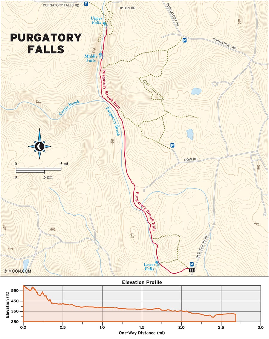
Tucked away in the hills north of Nashua, the Purgatory Brook Trail is an under-the-radar gem compared to the heavily trafficked trails of the nearby Monadnocks. While this makes for serene hiking, it also means that the trail can be overgrown. For a confusion-free trip, bring a printout of the trail map found on the Mont Vernon Conservation Commission website and watch the tree trunks for the yellow plastic strips that mark the path. If you’re hiking in late May or June, throw some bug spray in your day pack too: those 4-5 weeks are blackfly season in New Hampshire, and blackflies love running water.
 MILE 0-0.3: Purgatory Brook Trail to Lower Purgatory Falls
Begin your hike in the Lower Purgatory Falls parking lot by the trailhead sign and pick up the Purgatory Brook Trail heading west. Bear left at a Y-junction to stay on the main dirt path, which ambles through hemlocks at an even grade. After passing several reptile-rich vernal pools, the trail curves northwest and makes a quick descent to Lower Purgatory Falls at 0.3 mile. The shoreline that circles the pool of the explosive 25-foot-tall cascade is ideal for picnickers and landscape photographers, making this a popular place.
 MILE 0.3-1.7: Lower Purgatory Falls to Purgatory Brook
Leaving the crowds behind, the trail climbs the right side of the lower falls and flattens into a narrow, rockier path through mossy woods. Hugging the shore of Purgatory Brook, continue north and cross several mud patches on wooden plank bridges and logs. At 0.8 mile, turn right to avoid a bridge over Purgatory Brook. Continue for 0.9 mile as the forest expands into a great hall of deciduous hardwoods. Occasionally the trees part wide enough to offer pleasant views of Purgatory Brook, which are often complemented by rock slabs and boulders large enough to host a small group of picnickers.
 MILE 1.7-2.5: Purgatory Brook to Upper Purgatory Falls
The trail briefly merges with a gravel access road at 1.75 miles before veering sharply to the right to avoid another wooden bridge. Note that the markings on this right turn are a little tough to see if you’re not looking for them, especially since the intuitive thing to do when hikers encounter a bridge is to cross it. Bottom line: Don’t cross the bridge. Turn right instead.
Now it’s time for the final climb. The trail ascends a wooded ravine at a moderate grade for 0.7 mile. Be mindful of slippery exposed roots and loose rocks. Keep an ear open for the rumble of Upper Purgatory Falls and look for a small wooden sign; the falls can be viewed from an outlook just beyond this sign at 2.5 miles. The crashing 50-foot-tall falls are surrounded by sheer walls of granite. Extra-curious hikers can get a closer look by carefully scrambling down a steep gully to the pool. Return the way you came.
From Boston, drive north on I-93 to exit 37B. Merge onto I-95 S and drive 5.5 miles before turning right onto US-3 N. Continue north on US-3 N for 27.6 miles into New Hampshire. Take exit 8 toward Somerset Parkway and turn right onto NH-101A W. Drive 7 miles and turn left onto NH-101 W at the junction. Continue as the road curves north and look for the Lower Purgatory Falls parking lot on the left. If the parking lot is full, park alongside Purgatory Falls Road.
GPS COORDINATES: 42°51'31.6"N 71°41'40.1"W, 42.858790, -71.694483
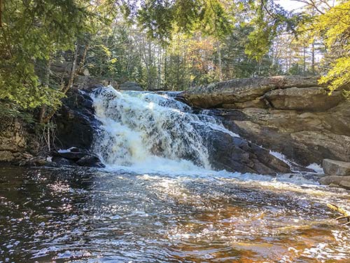
LOWER PURGATORY FALLS
MADAME SHERRI’S FOREST, CHESTERFIELD

Hike through lush forest and past the ruins of an old castle to a romantic vista overlooking the hills of Massachusetts.
BEST: New England oddities
DISTANCE: 4.0 miles round-trip
DURATION: 3 hours
ELEVATION CHANGE: 531 feet
EFFORT: Easy/moderate
TRAIL: Dirt path, rocks, wooden bridges
USERS: Hikers, leashed dogs
SEASON: May-October
PASSES/FEES: None
MAPS: Chesterfield Conservation Commission website
CONTACT: Town of Chesterfield, 603/313-1416, www.chesterfield.nh.gov
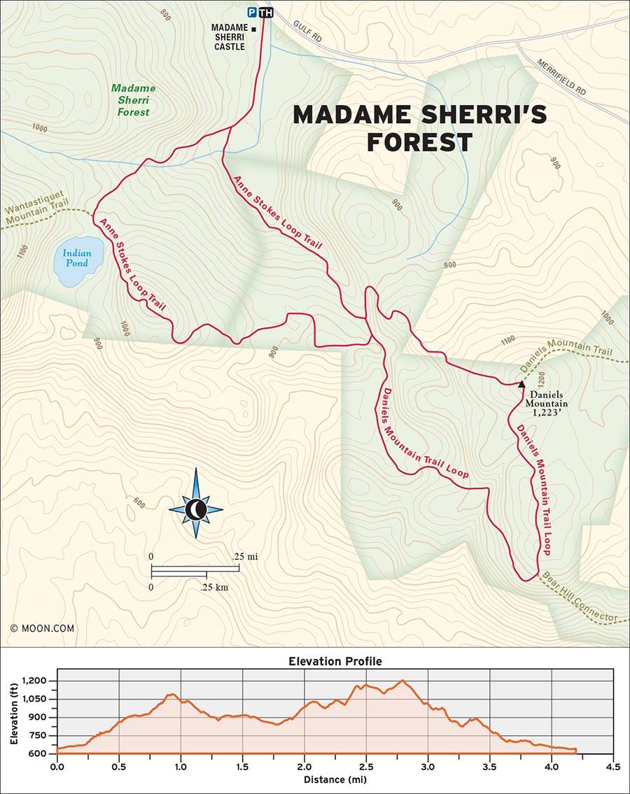
Back in the Gilded Age, a New York costume designer named Antoinette Sherri laid claim to this thick pocket of woods in the southwest tip of New Hampshire. Today, the ruins of her old forest castle form one of the region’s most evocative sights. Beyond the castle is vivid emerald foliage, amphibian-rich wetlands, and the wooded knoll known as Daniels Mountain. The park is a paradise for hikers who appreciate grown-in trails and the ambience of undeveloped (and under-visited) woodlands.
 MILE 0-0.7: Madam Sherri’s Forest Trailhead to Anne Stokes Loop
Begin your hike in the Madam Sherri’s Forest parking lot by crossing a wooden bridge and picking up the Anne Stokes Loop. Immediately, you’ll encounter a sign for the castle ruins. Veer right up a small hill to take a good gander at the ruins before merging back onto the Anne Stokes Loop, which is marked with brown diamonds bearing the name of the loop. Hike southeast past a marsh into a denser section of northern hardwood conifers. Turn left at the loop junction sign at 0.2 mile and continue 0.5 mile as the trail becomes rockier and rootier. Watch your step—frogs and garter snakes make regular crossings along this stretch of the trail.
 MILE 0.7-1.2: Anne Stokes Loop to Daniels Mountain Loop
As the trail begins to ascend, turn left at the junction with the Daniels Mountain Loop at 0.7 mile. Head north briefly before the trail takes a sharp right and slabs up the northern flank of Daniels Mountain at a moderate grade. The footing contains many exposed roots, so be mindful of your footing during wet weather. An exposed ledge offers a stunning view of the forest at 0.8 mile. Continue for another 0.4 mile on the final ascent to the top of Daniels Mountain.
 MILE 1.2-1.6: Daniels Mountain Loop to Daniels Mountain Summit
At 1.2 miles, you’ll be at the summit. Ironically, though, the best view is just below the summit. Turn right at the summit junction to continue along the loop trail and descend for 0.4 mile until you reach the sign for Moon Ledge. Here, at 1.6 miles, you’ll be treated to a vista of Massachusetts’s Pioneer Valley that could easily be the subject of a painting, especially near sunset.
 MILE 1.6-4.0: Daniels Mountain Summit to Anne Stokes Loop
Continue down the mountain on the Daniels Mountain Loop trail for another 0.7 mile and enjoy a brief foray through some wooded hollows before hooking up with the Anne Stokes Loop again at 2.3 miles. Take an immediate left onto the Anne Stokes Loop and ascend a rocky knoll called East Hill. The trail is steep in a few places but it quickly transitions from granite into lush vegetation. Enjoy a view of the nearby Indian Pond from the pinnacle of East Hill at 3.1 miles before concluding the loop hike with a gentle descent back into the forest. Upon reaching the end of the Anne Stokes Loop at 3.8 miles, turn left onto the familiar starter trail and backtrack past the castle ruins to the trailhead.
From Boston, drive to Cambridge’s Alewife Station and pick up MA-2 W/Concord Turnpike. Head northwest along MA-2 for 65 miles. After entering the town of Erving, turn right onto Church Street. Drive north as Church Street becomes North Street and then Gulf Road. Stay on this road until it ends at NH-63. Turn right onto NH-63 and drive north into New Hampshire. At the terminus of NH-63 in Hinsdale, turn left onto Main Street and then turn right onto Plain Road. Continue north along Plain Road for 5 miles until you reach Merrifield Road. Turn left onto Merrifield Road and then take a left onto Gulf Road. The Madam Sherri’s Forest trailhead and parking lot will be on your left, and a spillover parking area is located directly across the road on the right side.
GPS COORDINATES: 42°51'53.0"N 72°31'05.2"W, 42.864723, -72.518114
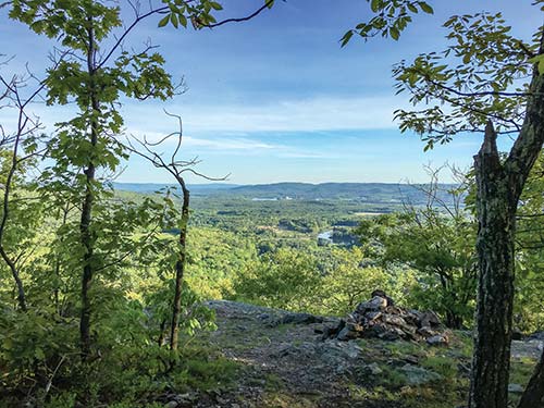
WESTERN MASSACHUSETTS FROM MOON LEDGE
HARRIS CENTER FOR CONSERVATION EDUCATION, HANCOCK

This family-friendly hike traverses a forest with an active bobcat population and visits two neighboring peaks that offer views of the Monadnocks and the Wapack Range.
DISTANCE: 5.0 miles round-trip
DURATION: 4 hours
ELEVATION CHANGE: 892 feet
EFFORT: Moderate
TRAIL: Dirt path, rocks, water crossings by stones
USERS: Hikers, leashed dogs
SEASON: May-October
PASSES/FEES: None
MAPS: Harris Center website
CONTACT: Harris Center for Conservation Education, 603/525-3394, www.harriscenter.org
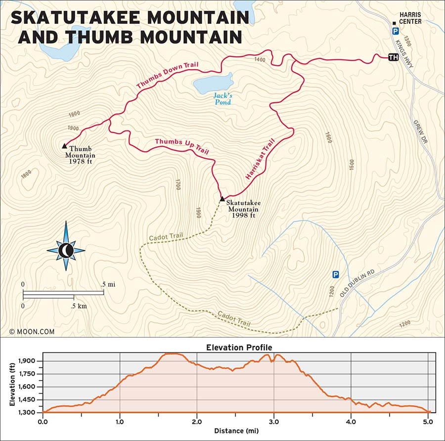
 MILE 0-0.2: Harris Center to Harriskat Trail
Begin your hike in the parking lot for the Harris Center by the Trails sign. Follow a dirt path down to the adjacent road (Kings Highway) and cross the road to pick up the Harriskat Trail, marked with white rectangles on trees. The trail begins with a pleasant meander through mossy, boulder-strewn woods with plenty of vernal pools and a few creeks to hopscotch across. Some of the hemlocks here are riddled with woodpecker holes.
 MILE 0.2-1.7: Harriskat Trail to Skatutakee Summit
Continue along this stretch for 0.6 mile before reaching the intersection of Harriskat and the Thumbs Down Trail. Turn left to continue on Harriskat. The trail segues into a series of switchbacks that ascend the northeastern haunch of Skatutakee Mountain at a surprisingly laid-back grade. As the trees start to thin out and the trail becomes rockier, the trail reaches the summit of Skatutakee at 1.7 miles, which is marked with a massive cairn. The summit resembles a high-altitude meadow with panoramic views of Keene, the Monadnocks, and the Wapack Range just across the state border in Massachusetts.
 MILE 1.7-2.3: Skatutakee Summit to Thumbs Up Trail
To continue the loop, turn right onto the Thumbs Up Trail at the summit junction with the Harriskat and Cadot Trails. (Look for white triangles on this section.) After a brief and relaxing descent from the top of Skatutakee, the trail veers west and begins its ascent to Thumb Mountain at 2.3 miles. The grade is somewhat gentler, but with more rocks and exposed roots.
 MILE 2.3-2.9: Thumbs Up Trail to Thumb Mountain Summit
Climb until you reach a junction with the Thumbs Down Trail at 2.6 miles. Turn left to stay on Thumbs Up and continue at a steeper angle for 0.3 mile before arriving at the summit proper at 2.9 miles. The top of Thumb is more grown-in with foliage than Skatutakee, but a clearing—complete with a stone victory bench—offers a direct and superior view of Mount Monadnock.
 MILE 2.9-3.3: Thumb Mountain Summit to Thumbs Down Trail
Begin the return journey by backtracking down the Thumbs Up Trail to the junction and turning left onto the Thumbs Down Trail, which is marked with yellow rectangles. The descent grade is moderate but the trail here is more rugged and less traveled. Keep an eye peeled for any of the local forest’s resident bobcats, which occasionally make brief but unforgettable appearances in the presence of lucky hikers.
 MILE 3.3-5.0: Thumbs Down Trail to Harriskat Trail
Continue the descent for roughly half a mile. The grade smoothens once the trail passes Jack’s Pond at 3.9 miles, and the remaining half mile is nearly level. At 4.4 miles, the Thumbs Down Trail concludes at the Harriskat Trail. Turn left onto Harriskat to return to the parking lot.
From Boston, pick up I-93 N and drive north for 73 miles into New Hampshire. Shortly after passing through the toll booth, take Exit 5 to merge onto I-89 N. Drive north for 9 miles and use the left lane to take Exit 5 onto US-202 W/NH-9 toward Henniker/Keene. Continue heading west and then southwest along NH-9 for 27 miles before taking a left onto NH-123. Turn right onto Hunts Pond Road and take it to its end, where you’ll turn left onto Kings Highway. The road transitions from concrete to dirt and the Harris Center parking lot will be on your left.
GPS COORDINATES: 42°58'41.9"N 72°01'13.8"W, 42.978309, -72.020505

THE ELUSIVE BOBCAT IN THE HARRIS CENTER WOODS
CROMMET CREEK CONSERVATION AREA, DURHAM

This gentle and wildlife-rich hike takes you from the middle of the New Hampshire woods through a series of wetlands to the salty and serene estuaries of Great Bay.
BEST: Winter hikes, brew hikes
DISTANCE: 5.6 miles round-trip
DURATION: 2.5 hours
ELEVATION CHANGE: 88 feet
EFFORT: Easy
TRAIL: Dirt path, wooden bridges, water crossings via stones
USERS: Hikers, leashed dogs
SEASON: April-October
PASSES/FEES: None
MAPS: Great Bay Resource Protection Partnership website
CONTACT: Great Bay Resource Protection Partnership, 603/659-2678, www.greatbaypartnership.org
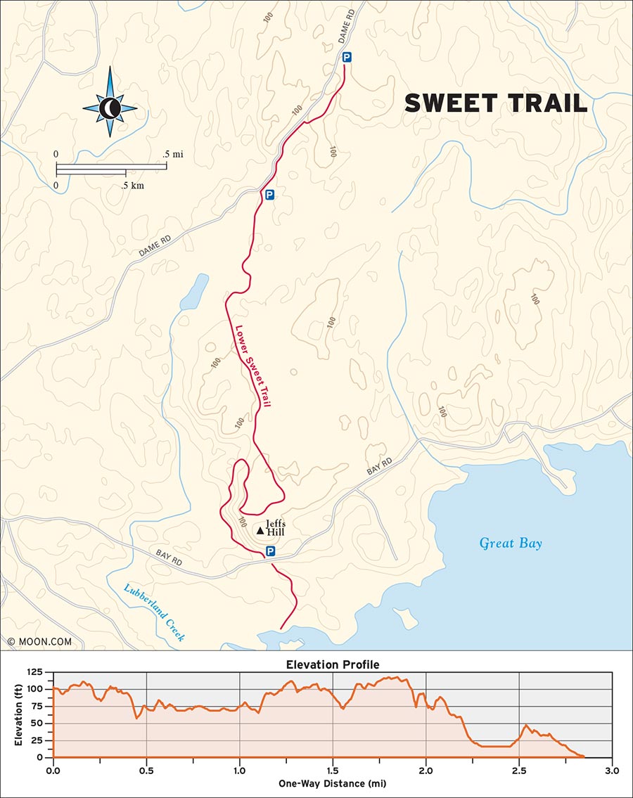
New Hampshire’s seacoast is an ecosystemic melting pot of deciduous forest and windswept coastal preserves. The Sweet Trail goes through both of these natural environments, making for a wondrous, family-friendly shrub-to-sea jaunt. Better yet, the protected forest and wetlands through which the Sweet Trail meanders are teeming with birds, amphibians, and beavers. From April to May, the entire area becomes a symphony hall for spring peepers.
 MILE 0-0.6: Sweet Trail to Footbridge
Begin your hike at the Crommet Creek parking lot by the trailhead sign and turn right onto the Sweet Trail, heading south. Blue-and-white diamond-shaped signs mark the trail. Descend through a thick stretch of hemlock forest for 0.3 mile before arriving at Dame Road. Take a left here and walk south along the dirt road until you reach a small parking lot on your left. From here, the Sweet Trail continues deeper into the woods. Watch your footing as the trail skirts a series of boulders beside a bog and crosses a creek on a precarious-looking but sturdy wooden footbridge. The bridge is a great outlook for spotting beavers, which can often be glimpsed fortifying their lodges in the boggy area that’s visible from this point of the trail.
 MILE 0.6-1.8: Footbridge to Sweet Trail
Leaving the bog and creek behind, the trail continues south and crosses a smaller stream on rocks at 0.9 mile before curving to the southeast and widening into a smoother dirt path. The trail ambles through a hall of hemlocks and birches before skirting a second, larger series of wetlands. Tread lightly and quietly here: not only do spotted salamanders and wood frogs regularly cross the forest floor, but the dead white pine snags of the nearby wetlands are the nesting grounds for a small group of great blue herons who occasionally make appearances. Keep an ear open for their deep-throated croak as you pass through here.
At 1.8 miles, the Sweet Trail reaches the upper flank of Jeff’s Hill. At this junction, hikers can choose to continue over the hill or stick with the Sweet Trail.
 MILE 1.8-2.8: Sweet Trail to Great Bay Estuary
Turn right to continue on the Sweet Trail as it takes a sharp curve north before turning south again and descending into one final wetland that partially engulfs the trail itself. Avoid the muck here by staying on the wooden bog bridges. The trail crosses Bay Road at 2.4 miles and ambles through a roomier stretch of hemlocks.
The trail finally emerges at the edge of the woods and reaches its end at the Great Bay estuary at 2.8 miles. Take a deep whiff of the briny sea breeze and plop down on the circular stone bench, which offers a splendid view of the coastal tides, before heading back the way you came.
From Boston, drive north on I-93 to exit 37B. Merge onto I-95 N. Continue north on I-95 for 25 miles and cross into New Hampshire. Take Exit 2 toward NH-101 to Hampton/Manchester. Follow the signs to State Route 101 W to Manchester/Concord. Merge onto 101 W and continue to Exit 10 for NH-85 to Exeter/Newfields. Turn right at the bottom of the exit ramp and head north on NH-85 for 3 miles before turning left onto NH-108. Drive north on 108 for another 3 miles and take a right onto Dame Road. The road soon goes from concrete to dirt and the trailhead parking is on your right at 65 miles. There is no fee or permit required for parking.
GPS COORDINATES: 43°06'01.4"N 70°54'16.3"W, 43.100386, -70.904540

WOOD FROG ALONG THE SWEET TRAIL
| NEARBY CAMPGROUNDS | ||||
|---|---|---|---|---|
| NAME | LOCATION | FACILITIES | SEASON | FEE |
| Ashuelot River Campground | 152 Pine St., Swanzey, NH 03446 | Tent sites, RV sites, cabins, toilets, showers, potable water, laundry, camp store, Wi-Fi | May-October | $45-70 |
| 603/357-5777, www.ashuelotrivercampground.com | ||||
| Shir-Roy Camping Area | 136 Athol Rd., Richmond, NH 03470 | Tent sites, RV sites, toilets, showers, potable water, laundry, camp store, Wi-Fi | late May-mid-October | $33-44 |
| 603/239-4768, www.shir-roy.com | ||||
| Gilson Pond Campground | 116 Poole Rd., Jaffrey, NH 03452 | Tent sites, toilets, showers, potable water | May-October | $18-25 |
| www.nhstateparks.org | ||||
| Seven Maples Campground | 24 Longview Rd., Hancock, NH 03449 | Tent sites, RV sites, cabins, toilets, showers, potable water, laundry, swimming pool, camp store, Wi-Fi | mid-May-mid-October | $49-129 |
| 603/525-3321, www.sevenmaples.com | ||||
| Oxbow Campground | 8 Deering Center Rd., Deering, NH 03244 | Tent sites, RV sites, cabins, toilets, showers, potable water, laundry, camp store, Wi-Fi | mid-May-mid-October | $30-65 |
| 603/464-5952, www.oxbowcampground.net | ||||
| Autumn Hills Campground | 285 S Stark Hwy., Weare, NH 03281 | Tent sites, RV sites, toilets, showers, potable water, laundry, camp store, Wi-Fi | May-mid-October | $33-49 |
| 603/529-2425, www.autumnhillscampground.com | ||||
| Sunset Park Campground | 104 Emerson Ave., Hampstead, NH 03841 | Tent sites, RV sites, yurts, toilets, showers, potable water, Wi-Fi | late May-early October | $30-75 |
| 603/329-6941, www.sunsetparknh.com | ||||
| Wakeda Campground | 294 Exeter Rd., Hampton Falls, NH 03844 | Tent sites, RV sites, cabins, toilets, showers, potable water, laundry, camp store, restaurant, Wi-Fi | mid-May-September | $43-92 |
| 603/772-5274, www.wakedacampground.com | ||||