
Geologically speaking, the Litchfield Hills are the southern continuation of the Berkshires, and they offer many of same spectacular interstate views, high rocky peaks, and abundant farmland fed by the flow of the Housatonic River. This rolling, rural landscape is a respite from the suburban feel that dominates much of Connecticut, and therefore a popular destination for vacationers and second-home owners. Those seeking outdoor adventure flock to the northernmost hills to ascend the highest peaks in the state, while the wide watershed of the Housatonic provides plenty of waterfront scenery at lower elevations. From the trusty corridor of the Appalachian Trail to the isolated lowland forests, there is a trail in northwestern Connecticut to suit every inclination.
1 Robert Ross and Agnes Bowman Trails
2 Appalachian Trail: Housatonic River Walk
4 Appalachian Trail: Prospect Mountain and Rand’s View
7 Mattatuck and Little Pond Loop “Boardwalk” Trail
8 Donkey Trail and Hodge Road Loop
9 Undermountain Trail, Appalachian Trail, and Paradise Lane Trail to Bear Mountain

PEOPLE’S STATE FOREST, BARKHAMSTED

This beautiful hike through pristine forest and over bubbling brooks delivers big views from its overlooks with very little effort.
BEST: Brew hikes
DISTANCE: 6.4 miles round-trip
DURATION: 3.5 hours
ELEVATION CHANGE: 1,019 feet
EFFORT: Moderate
TRAIL: Dirt/rock singletrack
USERS: Hikers, leashed dogs
SEASON: May-November
PASSES/FEES: $15 for nonresidents on weekends and holidays. No charge for CT residents; no charge on weekdays.
MAPS: Friends of American Legion and People’s State Forest, “American Legion and People’s State Forest Trail Map.”
CONTACT: Connecticut DEEP State Parks, 860/526-2336
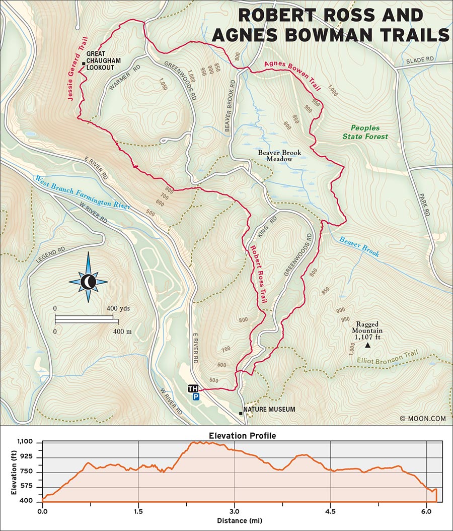
 MILE 0-0.3: Mathias Grove Parking Area to Robert Ross Trail
From the Mathias Grove parking area and trailhead, follow signs toward the Nature Museum, an educational facility built by the Civilian Conservation Corps in 1935. Reach the museum at 0.2 mile and turn left (north) toward the Agnes Bowen and Robert Ross Trail signs, following the blue and orange-blue blazes. At 0.3 mile, bear left on the blue-blazed Robert Ross Trail.
 MILE 0.3-2.2: Robert Ross Trail to Jessie Gerard Trail
The route chugs steadily uphill through an eclectic mix of trees and shrubs. At 1.0 mile from the trailhead, the trail widens and arrives at the King Road intersection. Turn left (northwest) to stay on the Robert Ross Trail. The path rolls downhill until intersecting the Agnes Bowen Trail again at 1.5 mile. Turn right (north) and then bear left (west) to continue on the Robert Ross Trail, which winds through a clearing and over a creek where a glacial erratic boulder keeps sentinel. There are some views to the west as the trail climbs uphill and wraps around a series of ledges. At 1.9 miles, reach the intersection with the Jessie Gerard Trail. Stay right on Robert Ross to reach the bridge and the intersection with Falls Cutoff at 2.0 miles. Check out the falls to the left (west) before following the Robert Ross Trail straight through the intersection on a rocky uphill path. At 2.2 miles, reach Warner Road and take the blue-and-yellow-blazed Jessie Gerard Trail straight north.
 MILE 2.2-2.7: Jessie Gerard Trail to Big Spring Area
At this steepest point in the hike, hundreds of stone steps lead uphill to the Great Chaugham Lookout. The vista offers excellent views of the Farmington River disappearing into a horizon of hills. At 2.4 miles from the trailhead, reach the second lookout, which faces northwest toward the river and Robertsville. As the trail navigates away from the lookouts and back into the woods, pass two more enormous erratics, known as the Veeder Boulders. From here, the path descends to an intersection at the Big Spring area at 2.7 miles.
 MILE 2.7-3.7: Big Spring Area to Beaver Brook Recreation Area
Take a right (east) at the Big Spring area intersection to stay on the Jessie Gerard Trail, then take a right (south) on Greenwoods Road. Follow the road through the group camping area, then turn onto the blue-and-yellow-blazed Charles Pack Trail on the left (east). At 2.8 miles, the trail crosses a wet area on a mossy patchwork of stones, crosses a gurgling creek, and descends on a soft pine needle trail. Reach Beaver Brook Road and turn left (north) over the bridge and into the Beaver Brook Recreation Area on your right (east).
 MILE 3.7-4.8: Beaver Brook Recreation Area to Agnes Bowman Trail
At 3.7 miles, the trail continues past the picnic tables and crosses Pack Grove Road twice before descending through a stand of huge pines toward a bog. This section of the trail is great for spotting wildflowers in spring. At 4.8 miles in, cross another bridge over Beaver Brook and take a left (south) onto the red-and-blue-blazed Agnes Bowman Trail.
 MILE 4.8-6.4: Agnes Bowman Trail to Nature Museum
At 5.8 miles, pass a camping area, continue downhill with the stream on your right (west), and then cross a road before meeting the Robert Ross Trail again. Take a left (south) to arrive back at the Nature Museum. Turn right (west) to return to the parking lot, completing the 6.4-mile hike.
From US-44, turn onto CT-318 in Barkhamsted. Cross the bridge and immediately turn left onto East River Road. The park entrance is on the left after 1 mile.
GPS COORDINATES: 41°55'32.0"N 72°59'57.8"W
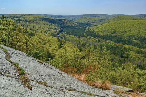
GREAT CHAUGHAM LOOKOUT
APPALACHIAN NATIONAL SCENIC TRAIL, KENT

This easygoing meander along the Housatonic River comprises a favorite flat section of the Appalachian Trail.
BEST: Winter hikes, brew hikes
DISTANCE: 7.6 miles round-trip
DURATION: 3.5 hours
ELEVATION CHANGE: 122 feet
EFFORT: Easy
TRAIL: Dirt singletrack
USERS: Hikers, leashed dogs
SEASON: Year-round
PASSES/FEES: None
MAPS: Appalachian Trail Conservancy, “Appalachian Trail,” Massachusetts-Connecticut
CONTACT: Appalachian Trail Conservancy, 304/535-633, http://appalachiantrail.org
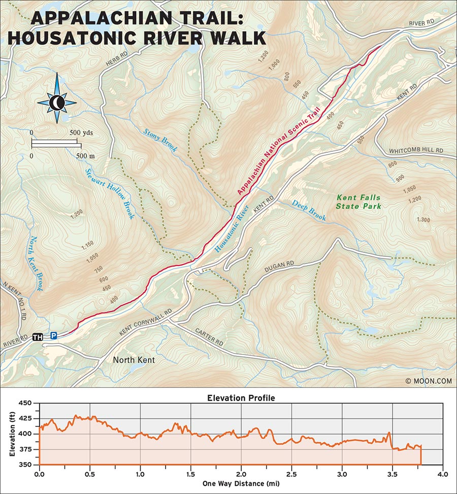
 MILE 0-1.3: Appalachian Trailhead to Stewart Hollow Brook Bridge
Hike north from the parking area, following the white blazes upstream on a wide, flat gravel path. The partially shaded trail follows a stone wall lined with a number of large maples, then crosses over North Kent Brook, a fairly wide stream. There is no bridge, so hikers may have to leap to make it over without getting wet. At 0.5 mile from the trailhead, the trail narrows and enters a stand of tall, skinny beech trees, which are particularly beautiful in fall when draped in yellow leaves. At 0.9 mile the trail returns to hug the west bank of the Housatonic River. Cross over the Stewart Hollow Brook on a wooden bridge at 1.3 miles, and pass the turnoffs to the Stewart Hollow campsite and group area.
 MILE 1.3-3.4: Stewart Hollow Brook Bridge to Housatonic Riverbank
The area includes a privy and a lean-to shelter that is a nice spot for a break. Continue to where the path diverts west away from the river and through a grassy open field with great views of the tree-covered Kent hillside rising up to the west, 2.9 miles in. At 3.4 miles, the path winds through bramble back to the water’s edge. This unique ecosystem is a popular place to spot rare bird species.
 MILE 3.4-7.6: Housatonic Riverbank to Gravel Road and Trailhead
When the trail reaches an intersection with a gravel road at 3.8 miles, turn around and backtrack to the trailhead to complete the 7.6-mile loop.
From downtown Kent, take CT-341 west for about 0.2 mile, then turn right onto Skiff Mountain Road. At the fork in 1 mile, bear right onto River Road. The parking area and trailhead is at the end of the road in about 2.5 miles.
GPS COORDINATES: 41°46'06.5"N 73°26'06.8"W
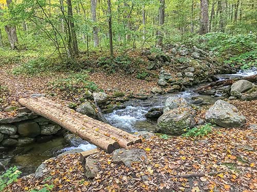
BRIDGE ON THE APPALACHIAN TRAIL
HOUSATONIC MEADOWS STATE PARK, SHARON

A quick hike along rolling cascades up to the Pine Knob lookouts results in lovely views of the Litchfield Hills.
DISTANCE: 2.5 miles round-trip
DURATION: 2 hours
ELEVATION CHANGE: 765 feet
EFFORT: Moderate
TRAIL: Dirt/rock singletrack
USERS: Hikers, leashed dogs
SEASON: May-November
PASSES/FEES: None
MAPS: Connecticut Forest and Park Association, “Blue Blazed Hiking Trail System/Connecticut Walk Book”
CONTACT: Connecticut Forest and Park Association, 860/346-8733, http://ctwoodlands.org
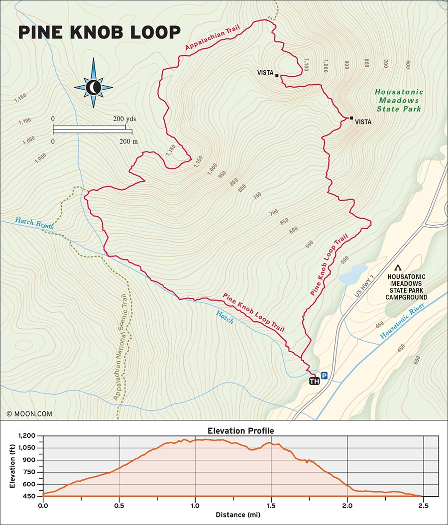
 MILE 0-0.4: Pine Knob Loop Parking Area to Housatonic Meadows State Park Campground
Follow the blue blazes west from the parking area, cross over Hatch Brook on foot, and then reach a stone wall where a sign marks the merger of the ends of the Pine Knob Loop in 400 feet. For this counterclockwise route, turn right (north) along the stone wall. The flat trail winds over several creeks, passing the spur to the Housatonic Meadows State Park Campground in 0.4 mile.
 MILE 0.4-1.0: Housatonic Meadows State Park Campground to First Vista
From the spur, the path climbs switchbacks to meet a small waterfall at 0.6 mile. Continue past the waterfall and climb a rocky ridgeline with some scrambling to reach the first vista at 1.0 mile. This east-facing lookout peers over nearby conifers for fantastic views of the Litchfield Hills and the Housatonic River valley on a clear day. Fog coming off the river below can add an enchanted quality to the forested vista on a cool morning.
 MILE 1.0-1.6: First Vista to Second Vista
Cross over the hilltop northwest of the vista, descend, and reach a sign marking the intersection with the Appalachian Trail (AT) at 1.1 mile. Turn left (west) onto the AT southbound to continue the Pine Knob Loop. The blazes become white and blue when the Pine Knob Trail and the AT merge. The trail traverses the flat saddle between Pine Knob’s two peaks. Reach the narrow, east-facing vista atop the second peak at about 1.6 miles.
 MILE 1.6-2.5: Pine Knob Peaks to Hatch Brook
After taking in the vista, continue to 1.9 miles, where the Pine Knob Loop departs the Appalachian Trail at a marked intersection and the white-and-blue blazes end. Turn left (south) following only the blue blazes, which continue downstream along Hatch Brook. Hikers will pass large boulders and a series of cascades. Return to close the loop at 2.5 miles and turn right (south) to cross the brook and return to the parking area.
The parking area for the Pine Knob Loop is marked with a blue sign on the west side of US-7, approximately 1 mile north of Cornwall Bridge.
GPS COORDINATES: 41°49'59.6"N 73°22'59.8"W
APPALACHIAN NATIONAL SCENIC TRAIL, FALLS VILLAGE

Wander over the summit of Mount Prospect to the sprawling fields of Rand’s View, tucked underneath the peaks of the Berkshire hills.
BEST: Spring hikes, vistas
DISTANCE: 5.2 miles round-trip
DURATION: 2.5 hours
ELEVATION CHANGE: 979 feet
EFFORT: Moderate
TRAIL: Dirt/rock singletrack
USERS: Hikers, leashed dogs
SEASON: May-November
PASSES/FEES: None
MAPS: Appalachian Trail Conservancy, “Appalachian Trail,” Massachusetts-Connecticut Map 3
CONTACT: Appalachian Trail Conservancy, 304/535-633, http://appalachiantrail.org
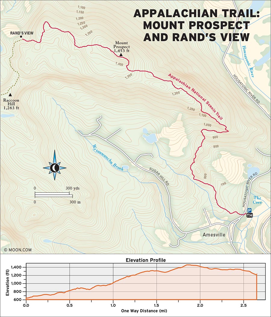
 MILE 0-0.2: Prospect Mountain Trailhead Parking Lot to Meadow
From the gated parking area at the falls, cross Housatonic River Road and hike west, following the white blazes uphill for 0.2 mile. The trail winds past a large boulder and enters a meadow, a great spot to glimpse deer and other wildlife feeding in the morning and evening.
 MILE 0.2-1.6: Meadow to Prospect Mountain Summit
Travel through an airy beech and maple forest for another 0.2 mile, then dip alongside a stream on the right (east) side of the trail. Cross the stream on foot heading straight (north) and follow the path over several rolling hills for 0.5 mile until the trail bends sharply left (northwest). Begin the 0.7-mile ascent to the rocky ridgeline of Prospect Mountain. The trail eases into a soft dirt track leading to the summit of Prospect at 1.6 miles. A narrow but pretty vista looks west toward the Housatonic River and a series of marshes bordered by green hills.
 MILE 1.6-2.6: Prospect Mountain Summit to Rand’s View
The trail continues straight (west) along the summit. Cross a stone wall and then descend a hill to the signed intersection with the Limestone Shelter spur at 2.5 miles. Turn right (west) to stay on the Appalachian Trail. In 0.1 mile, the trail arrives at Rand’s View, a grassy, wide-open clearing with wildflowers and fantastic views of the Berkshire Range.
 MILE 2.6-5.2: Rand’s View to Housatonic River Road
After enjoying the view, turn around and backtrack the same route across Prospect Mountain and down the ridgeline to Housatonic River Road.
Take US-7 to the intersection with CT-126 in Falls Village and go west on CT-126. Pass through the center of town, turn left onto Water Street, and pass under a railroad bridge. Shortly after, cross an iron bridge and take the first right onto Housatonic River Road. There is a large gated gravel parking area at the falls in 0.4 mile.
GPS COORDINATES: 41°57'47.8"N 73°22'22.9"W

RAND'S VIEW
MACEDONIA BROOK STATE PARK, KENT

A woodsy loop around a hillside includes views from Cobble Mountain and scenic stretches along the Macedonia Brook.
DISTANCE: 6.4 miles round-trip
DURATION: 3.5 hours
ELEVATION CHANGE: 1,429 feet
EFFORT: Moderate/strenuous
TRAIL: Dirt/rock singletrack, gravel road
USERS: Hikers, leashed dogs
SEASON: May-November
PASSES/FEES: Camping only
MAPS: Connecticut DEEP, “Macedonia Brook State Park”
CONTACT: Connecticut DEEP State Parks, 860/526-2336
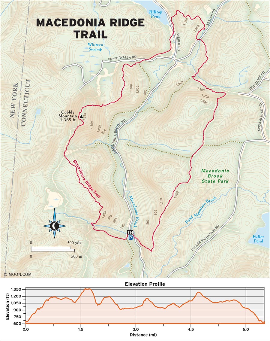
 MILE 0-1.5: Macedonia Ridge Trailhead to Cobble Mountain Summit
To complete the loop clockwise, hike toward the red outhouse and then turn left (south), crossing a stream via a bridge and following the blue blazes. Ascend a hill and cross the stream again in 0.3 mile. The trail climbs up to a ridgeline with increasingly good east-facing views of the Housatonic River valley. Blueberry bushes line the way as the path dips into a pocket of laurel, then ascends a grassy slope to the summit of Cobble Mountain 1.5 miles in.
 MILE 1.5-2.7: Cobble Mountain Summit to Macedonia Brook State Park
Follow the blue-and-white blazes north across the summit. There are great vistas facing east over the Macedonia Brook valley and west into New York and the Taconic Range. From Cobble Mountain, the trail descends through ledges for 0.8 mile; hikers may need to use their hands to lower themselves. At the end of the descent, the trail meets a wide gravel road. Turn left (north) and follow the gravel road straight across the paved street and through the gate on the other side. The route travels along a rock wall and meets another gate at the wooden Macedonia Brook State Park sign at 2.7 miles.
 MILE 2.7-3.6: Macedonia Brook State Park to Macedonia Brook Bridge
Cross the street, and walk left (north) for about 100 feet to a trail sign. At the trail sign, turn right (east) into the woods. There are glimpses of Hilltop Pond to the left (east) as the trail winds up a hillside of hemlock for 0.3 mile. Cross through an opening in a stone wall and past a meadow and bog for another 0.3 mile. The trail bends alongside Macedonia Brook for 0.2 mile, then crosses over the brook and Keeler Road on a bridge at 3.6 miles.
 MILE 3.6-6.4: Macedonia Brook Bridge to Macedonia Brook Road
At 4.2 miles, the trail crosses another narrow stream and then bends south. Travel through a rolling beech and maple forest lined with stone walls, and reach the intersection with the green-blazed trail at 4.9 miles. Keep straight (south) through the woods until the trail meets Macedonia Brook Road in 1.3 mile. Cross the road and turn right (northwest) to return to the parking area.
From downtown Kent, take CT-341 west for 1.6 miles and then turn right onto Macedonia Brook Road. Follow the road into Macedonia Ridge State Park. The parking area is marked with a small blue-blazed post labeled “Trail” on the left side of the road in about 1.3 miles.
GPS COORDINATES: 41°45'39.4"N 73°29'37.8"W
STEEP ROCK PRESERVE, WASHINGTON

Explore the banks of the Shepaug River from suspension bridges, railroad tunnels, and flat, forested carriage roads.
BEST: Spots for a swim
DISTANCE: 4.4 miles round-trip (with optional detour)
DURATION: 2 hours
ELEVATION CHANGE: 482 feet
EFFORT: Moderate
TRAIL: Dirt/rock singletrack, gravel road
USERS: Hikers, leashed dogs, horseback riders, cross-country skiers
SEASON: May-November
PASSES/FEES: None
MAPS: Steep Rock Association, “Steep Rock Preserve Trail Map”
CONTACT: Steep Rock Association, 860/868-9131, http://steeprockassoc.org
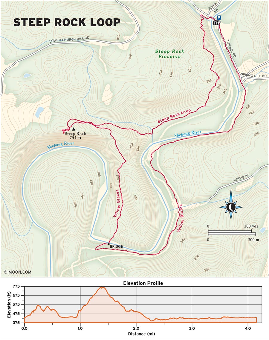
 MILE 0-1.2: Steep Rock Loop Trailhead to Steep Rock Lookout
Travel west over the bridge from the parking area and then turn left (south) onto the yellow-blazed Steep Rock Loop trail. The shady dirt path turns right (north), runs along the stream bank for 150 feet, and then switchbacks uphill through ledges. Reach a fork in 0.7 mile and bear right (southwest). The trail continues straight southwest and winds through a thick forest on a soft pine needle-covered track before it begins to climb steeply for 0.3 mile. At the intersection on the top of the hill, turn right (north) to follow the yellow blazes to the Steep Rock lookout at 1.2 miles, with great views of the Shepaug River.
 MILE 1.2-2.2: Steep Rock Lookout to Suspension Bridge
After enjoying the view, backtrack 0.2 mile east to the intersection and continue straight (south). The trail descends a hill and then bends right (west), following both yellow and green blazes for 0.8 mile along a wide carriage road overlooking the river. Drop into a forest of massive pines and arrive at a suspension bridge over the river at 2.2 miles.
 MILE 2.2-4.4: Suspension Bridge to Tunnel Road
Cross the bridge and then turn right (west) to follow the yellow blazes 0.1 mile to a gravel road. (Optional: Follow the blue trail west for 0.3 mile to hike through the 235-foot-long rock railroad tunnel, a photogenic underpass originally constructed as part of the Shepaug Valley Railroad.) Continue east on the wide gravel Tunnel Road, following the yellow blazes upstream directly alongside the river. The road arrives back at the parking area in 1.8 miles.
Take CT-47 into Washington Depot and turn right onto River Road. In 1.4 miles, turn left onto Tunnel Road. The large gravel parking area is just after the bridge.
GPS COORDINATES: 41°37'17.5"N 73°19'30.6"W
WHITE MEMORIAL CONSERVATION CENTER, LITCHFIELD

This novel hike includes more than a mile of boardwalk over the scenic marshland of Little Pond and the Bantam River.
DISTANCE: 3.2 miles round-trip
DURATION: 1.75 hours
ELEVATION CHANGE: 139 feet
EFFORT: Easy
TRAIL: Gravel road, dirt singletrack, wooden boardwalk
USERS: Hikers, leashed dogs
SEASON: Year-round
PASSES/FEES: None
MAPS: White Memorial Conservation Center, “WMF Property Map”
CONTACT: White Memorial Conservation Center, 860/567-0857, http://whitememorialcc.org
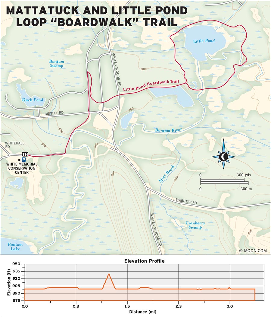
 MILE 0-0.5: Nature Museum to Bissell Road
With the museum to your right, follow the gravel road east for about 0.2 mile. At the stone-pillared gate, turn left (north) onto the blue-blazed Mattatuck Trail, which runs through a boggy area along a section of the Bantam River. Reach the intersection with Bissell Road, 0.5 mile from the trailhead, and cross straight (north) through the gate and into a forest of tall pines.
 MILE 0.5-2.2: Bissell Road to Sutton’s Bridge and Boardwalk
In approximately 400 feet, turn right (east) onto the black-and-white blazed Little Pond Loop Trail. After crossing Whites Woods Road, the trail continues east down a grassy path. At the intersection at 1 mile, turn right (south) to complete the boardwalk circuit counterclockwise. The boardwalk winds over the Bantam River and around the surrounding marsh for 1.2 miles. Sutton’s Bridge, a high wooden arch bridge at the beginning of the boardwalk, is a particularly scenic perch to look out over the river and the high cattails and colorful grasses that envelop the trail. Hikers with keen eyes may spot waterfowl, beavers, and a variety of wildflowers in the spring and early summer.
 MILE 2.2-3.2: Boardwalk to Little Pond Loop Trail
Continue counterclockwise around the boardwalk, which splits in 0.8 mile. Keep left to stay on the Little Pond Loop Trail, which ends at the intersection in 0.4 mile. Turn right (west) at the intersection to backtrack 1 mile to the museum and parking area.
From Litchfield Center, take US-202 west for 2 miles, then turn left onto Bissell Road. In 100 feet, turn right onto Whitehall Road. There is a large parking area and a trail sign at the visitors center and museum.
GPS COORDINATES: 41°43'27.3"N 73°12'46.5"W
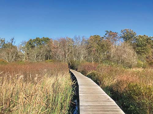
LITTLE POND LOOP “BOARDWALK” TRAIL

Delve into Connecticut’s mining history on these trails surrounding the ruins of an 1860s ironworks.
BEST: New England oddities
DISTANCE: 3.3 miles round-trip
DURATION: 2.75 hours
ELEVATION CHANGE: 675 feet
EFFORT: Moderate
TRAIL: Dirt/rock singletrack, gravel road
USERS: Hikers, leashed dogs, horseback riders, cross-country skiers
SEASON: May-November
PASSES/FEES: None
MAPS: Roxbury Land Trust, “Mine Hill Preserve/Carter Preserve Trail Map”
CONTACT: Roxbury Land Trust, 860/350-4148, http://roxburylandtrust.org
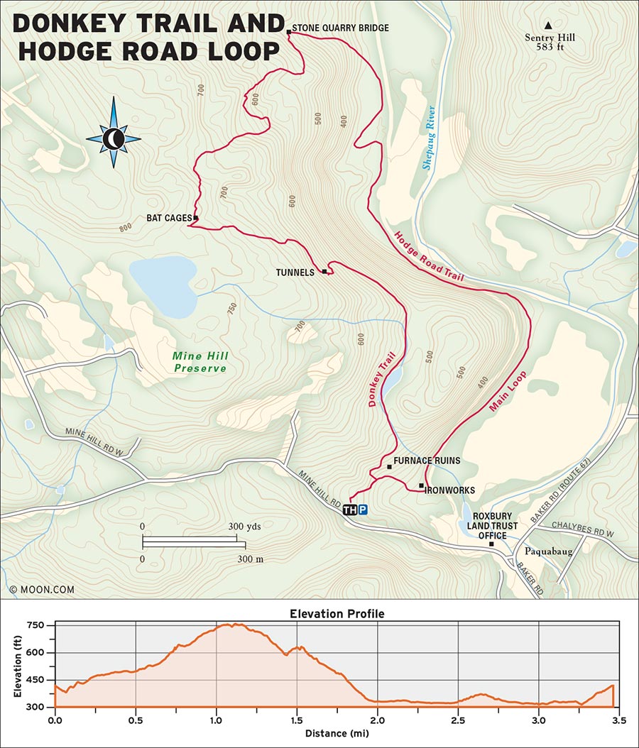
 MILE 0-0.6: Donkey Trailhead to Tunnel Entrance
Follow the blue blazes east from the trailhead to an intersection in 390 feet, then turn left (north) onto the Donkey Trail. This blue-blazed path carries hikers for 0.2 mile above the former Roasting Ovens, double stone cylinders used by the ironworks to heat raw ore. From the ovens, the route continues straight north on a raised rock path. Pass the bog and Nature Trail on the right (east) side of the trail, then arrive at a grated tunnel entrance (you can't walk through it) on the left (west) at 0.6 mile.
 MILE 0.6-1.7: Tunnel Entrance to Hodge Road Trail
Follow the trail left (west) uphill past the tunnel for 0.1 mile to the grated “bat cages,” which protect the entrances to several bat hibernacula. At 1.0 mile, reach a signed intersection where the Donkey Trail bends right (north) to wander through laurel and ledges. At the cliff and the small granite quarry bridge at 1.7 miles, turn right (west) onto the Hodge Road Trail.
 MILE 1.7-3.3: Hodge Road Trail to Donkey Trailhead and Parking Area
This wide path follows the stream downhill for 0.5 mile and delves into a spacious forest where the terrain flattens into a field. Reach a sign at the edge of the field and follow Hodge Road to the right (south). This gravel road parallels the Shepaug River for about 1 mile before reaching the enormous stone cold-blast furnace, brick chimney, and other remnants of the 19th-century ironworks. This is a good spot to stop, explore, and read the interpretive signs before heading southwest on the trail 0.3 mile back to the parking area.
Take CT-67 west from Roxbury for 2.3 miles, then turn right onto Mine Hill Road. The parking area is marked with a large sign on the right-hand side.
GPS COORDINATES: 41°33'35.1"N 73°20'17.9"W
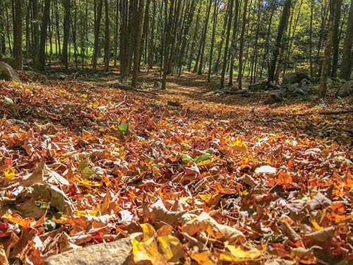
DONKEY TRAIL
MOUNT RIGA STATE PARK SCENIC RESERVE, SALISBURY

The tallest peak in Connecticut offers big views from its summit before the Appalachian Trail delves into Sage’s Ravine.
BEST: Fall hikes, vistas
DISTANCE: 6.1 miles round-trip
DURATION: 3 hours
ELEVATION CHANGE: 1,547 feet
EFFORT: Strenuous
TRAIL: Dirt/rock singletrack
USERS: Hikers, leashed dogs
SEASON: May-November
PASSES/FEES: None
MAPS: Appalachian Trail Conservancy, “Appalachian Trail,” Massachusetts-Connecticut Map 4
CONTACT: Appalachian Trail Conservancy, 304/535-633, http://appalachiantrail.org
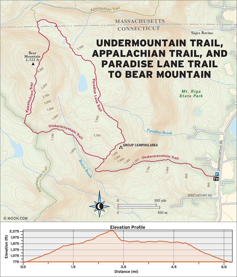
 MILE 0-1.9: Undermountain Trailhead to Appalachian Trail
From the small sign marking the trailhead, hike west on the Undermountain Trail, following the blue blazes up a slight incline through thickets of laurel. Around 0.6 mile in, the path gets steeper, winding up the hillside to meet a ravine. At the signed intersection with the Paradise Lane Trail at 1.2 miles, bear left (west) toward the Appalachian Trail (AT)/Bear Mountain, then bear left again at the next sign in 200 feet. The trail winds over several bog bridges and up a set of timber steps to reach a large sign at the Riga Junction at 1.9 miles. Turn right (north) onto the Appalachian Trail northbound toward Bear Mountain.
 MILE 1.9-2.6: Appalachian Trail to Bear Mountain Summit
Follow the white-blazed trail to a fork at 2.0 miles, and bear right (northeast). From here, a set of stone steps begins an ascent to the bare, rocky peak. Vistas improve the higher hikers climb, but the crown jewel is the rock tower atop the summit at 2.6 miles. The best views stretch northwest toward Mount Everett and Mount Race in Massachusetts and northeast toward the “twin lakes” of Salisbury.
 MILE 2.6-3.1: Bear Mountain Summit to Paradise Lane Trail
Continue north on the AT, descending a steep, rocky slope. Use caution through this section, especially during wet weather. The trail flattens in 0.5 mile and briefly enters Massachusetts, where hikers will reach a large sign for Sage’s Ravine at 3.1 miles. Turn right (east) onto the blue-blazed Paradise Lane Trail, which continues uphill through a hemlock forest. Through the trees, there are great views of Bear Mountain overlooking the bog to the right (west) of the trail.
 MILE 3.1-6.1: Paradise Lane Trail to Undermountain Trailhead
At 4.6 miles in, pass the group camping area (a privy is available here). Continue for 0.3 mile to return to an intersection with the Undermountain Trail. Turn left (south) to follow the Undermountain Trail 1.2 miles back to the parking lot.
Take CT-41 north from the center of Salisbury. In 3.3 miles, a small blue sign for the Undermountain Trail marks the small free parking area on the left side.
GPS COORDINATES: 42°01'43.6"N 73°25'43.4"W
| NEARBY CAMPGROUNDS | ||||
|---|---|---|---|---|
| The Housatonic River Walk, Rand’s View, and Bear Mountain hikes have primitive campsites on or near the routes. | ||||
| NAME | LOCATION | FACILITIES | SEASON | FEE |
| American Legion State Forest, Austin Hawes Campground | 198 W River Rd., Barkhamsted, CT 06063 | 30 RV/tent sites, 6 cabins; toilets | mid-April-early September | $27-60 |
| 860/379-0922, https://www.ct.gov/deep/cwp/view.asp?a=2716&q=325054 | ||||
| Macedonia Brook State Park | 159 Macedonia Brook Rd., Kent, CT 06757 | 51 RV/tent sites; toilets | mid-April-early September | $24 |
| 860/927-4100, https://www.ct.gov/deep/cwp/view.asp?a=2716&q=325234 | ||||
| Housatonic Meadows State Park | 90 Route 7, Sharon, CT 06069 | 61 RV/tent sites; toilets | late May-early October | $27 |
| 860/672-6772, https://www.ct.gov/deep/cwp/view.asp?a=2716&q=325220 | ||||
| Lake Waramaug State Park | 30 Lake Waramaug Rd., New Preston, CT 06777 | 76 RV/tent sites, 6 cabins; toilets | late May-early September | $27-60 |
| 860/868-0220, https://www.ct.gov/deep/cwp/view.asp?a=2716&q=325232 | ||||
| White Memorial Family Campground | N Shore Rd., Bantam, CT 06750 | 65 RV/tent sites; toilets | early May-mid-October | $9.50 wooded sites, $14.50 waterfront, $19.50 RV |
| 860/567-0857, http://www.whitememorialcc.org/family-camping | ||||
| Steep Rock Preserve | 2 Tunnel Rd., Washington Depot, CT 06794 | 3 tent sites; toilets | mid-April-mid-November | $35 |
| 860/868-9131, http://www.steeprockassoc.org/explore/camping/ | ||||
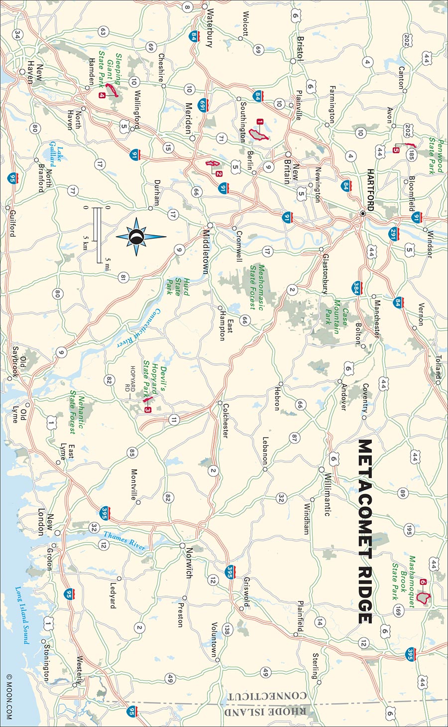
The Metacomet Range is the fault block ridge that winds its way up from Long Island Sound, through central Connecticut, and well into central Massachusetts alongside the Connecticut River. The steep and narrow ridge is home to miles of hiking trails that creep along traprock cliff faces and descend through bubbling stream corridors and vividly hued swamps. As the only high ground within miles of farmland and the sprawling metropolitan area of Hartford, the ridge is a popular destination for outdoor recreation. Its trails include the southern section of the 114-mile Metacomet-Monadnock Trail, as well as several local and state parks that are the pride and joy of Connecticut.
1 Preserve and Metacomet Trails to Ragged Mountain
2 Mattabesett Trail to Mount Lamentation and Chauncey Peak
3 Vista Trail, Devil’s Hopyard State Park
5 Talcott Mountain Trail to Heublein Tower
6 Blue Trail to Wolf Den and Indian Chair
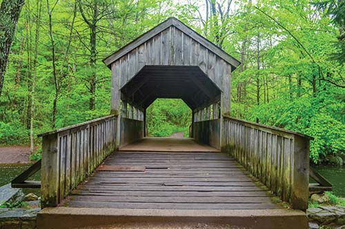
COVERED BRIDGE IN DEVIL'S HOPYARD STATE PARK
RAGGED MOUNTAIN PRESERVE, SOUTHINGTON

Although the climb to the summit of Ragged Mountain is relatively gentle, the views from its sheer traprock precipices overlooking the reservoirs and hills of central Connecticut are rewarding.
BEST: Vistas
DISTANCE: 5.3 miles round-trip
DURATION: 2 hours
ELEVATION CHANGE: 637 feet
EFFORT: Easy
TRAIL: Dirt/gravel path
USERS: Hikers
SEASON: April-November
PASSES/FEES: Donations appreciated
MAPS: Connecticut Forest and Park Association “Ragged Mountain Preserve”
CONTACT: Ragged Mountain Foundation, http://raggedmtn.org
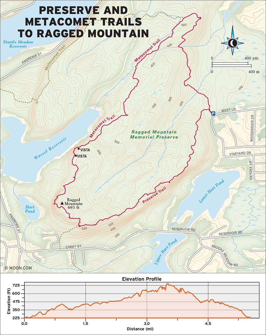
 MILE 0-0.8: Preserve Trailhead to Blue and White Trail
Follow the blue and red blazes of the Preserve Trail west from the trailhead to a three-way intersection at 215 feet. Turn right (north) at the intersection, then turn left (west) in 0.2 mile to stay on the Preserve Trail. The path is a wide, rolling doubletrack for 0.1 mile until it jumps a creek on stepping-stones and ascends a steep, very rocky section for 0.1 mile. Just after this rocky section, the path skirts a grassy slope, gradually gaining elevation to the north. At 0.8 mile, the Preserve Trail reaches an intersection with the Blue and White Trail.
 MILE 0.8-1.4: Blue and White Trail to Metacomet Trail
Go straight (north) on the Blue and White Trail for the best views. At 1.2 miles, there is a nice vista to the right (east). Enjoy the views looking out on the wooded hillside from this grassy knoll, but be mindful of poison ivy. From the overlook, the trail drops quickly in and out of a deep rocky ravine for 0.1 mile before it levels out and reaches a signed intersection at 1.4 miles. Take a left (south) onto the blue-blazed Metacomet Trail.
 MILE 1.4-3.4: Metacomet Trail to Hartford Skyline Vista
From here, the hike is mostly over a flat ridge top brimming with vernal pools. The trail passes some minor intersections, but keep following the blue blazes to stay on the Metacomet Trail. At 2.9 miles, reach a west-facing vista with nice views of the reservoirs below. At 3.4 miles, arrive at another, even wider vista where you can spot the Hartford skyline to the north.
 MILE 3.4-3.8: Hartford Skyline Vista to Ragged Mountain Summit
From here, the trail snakes back into the woods, descends a ledge, and rolls over some rooty ups and downs. Arrive at the summit at 3.8 miles, with views facing primarily south toward Short Mountain.
 MILE 3.8-5.3: Ragged Mountain Summit to Preserve Trailhead
Descend via the Red and Blue Trail, which serves up views of the Hart Ponds to the east from various lookouts along the way. The traprock trail is rugged as it passes this vista, but it smooths out about 1 mile from the summit. From here, the trail widens and continues north 0.5 mile to the trailhead.
From New Britain, turn left (south) onto Kensington Avenue, which becomes High Road. In 1.8 miles, turn right onto West Lane. The roadside parking area is marked with a sign on the right in about 0.8 mile.
GPS COORDINATES: 41°37'41.8"N 72°48'13.6"W
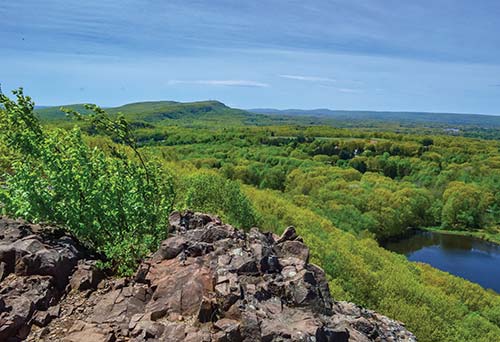
VIEW FROM RAGGED MOUNTAIN
GIUFFRIDA PARK, MERIDEN

This little gem of a park right outside the city of Meriden includes a quick climb to the ledges of Lamentation Mountain and Chauncey Peak, with placid views over Crescent Lake.
DISTANCE: 3.8 miles round-trip
DURATION: 2 hours
ELEVATION CHANGE: 598 feet
EFFORT: Moderate
TRAIL: Dirt/rock singletrack, gravel road
USERS: Hikers, leashed dogs
SEASON: April-November
PASSES/FEES: None
MAPS: Meriden Land Trust, “Giuffrida Park”
CONTACT: Meriden Land Trust, 203/630-4259, http://meridenlandtrust.com
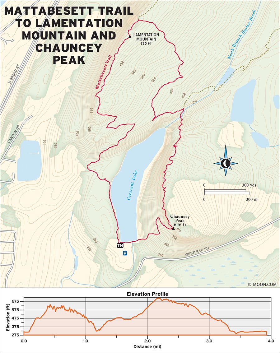
 MILE 0-1.2: Mattabesett Trailhead to Mount Lamentation Summit
Hike north from the parking lot, following the blue-blazed Mattabesett Trail along the wide, pine needle-lined shores of Crescent Lake to your right (east). In 0.3 mile, the Mattabesett Trail turns left (west) away from the water, crosses a paved street, and then turns right (north) onto a gravel access road in 160 feet. Follow the gravel road north along the power lines for about 100 feet, then continue right (north) on the Mattabesett Trail where it retreats into the woods. There is a quick, taxing uphill hike for 0.1 mile to a lower ridge with intermittent views of Chauncey Peak through the trees. In 0.1 mile, reach an intersection and continue straight (north) following the blue blazes. Reach another intersection in 0.4 mile and turn left (west), following the blue blazes again. In 0.3 mile, the trail climbs to the summit of Mount Lamentation.
 MILE 1.2-2.9: Mount Lamentation Summit to Chauncey Peak
There are several west-facing vistas along this narrow, grassy, cliff-top path, from which you can spot the Hartford skyline as well as soaring turkey vultures. At the intersection with the yellow-blazed trail at 1.8 miles, turn right (west) to follow the yellow-blazed trail, which descends from the summit on a rocky path. At the intersection at 2.5 miles, turn left (north) onto the red-blazed trail, which descends east toward Crescent Lake. In 0.2 mile, it rejoins with the blue-blazed Mattabesett Trail. Turn right (south) to follow the blue blazes on the wide crushed-stone path along the deep water-filled ravine to your left (east). Cross left (east) over the ravine on the small wooden bridge in 210 feet. The blue-blazed trail then ascends the north side of Chauncey Peak with some steep but short climbs. At 2.9 miles, reach the first of many vistas along the summit of Chauncey Peak.
 MILE 2.9-3.8: Chauncey Peak to Mattabessett Trailhead
These sheer traprock cliffs offer great views of Crescent Lake and Mount Lamentation, and their west-facing orientation makes them great for watching a sunset. Continue straight (south) along the ridge. At the signed intersection at 3.4 miles, turn right (west) to descend the south side of the peak on the Mattabessett Trail. This 0.4-mile return to the parking lot is a combination of steep staircases and loose traprock, so descend with care!
From Meriden, take I-691 E and then take exit 8 for US-5. Turn right onto US-5 N, then turn right onto Westfield Road in 0.5 mile. At the intersection in 1 mile, turn left to stay on Westfield Road. A large sign on the left marks the entrance to the park in 0.4 mile.
GPS COORDINATES: 41°33'22.8"N 72°45'50.5"W
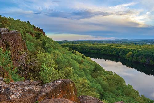
VIEW FROM CHAUNCEY PEAK
DEVIL’S HOPYARD STATE PARK, EAST HADDAM

Start your hike with an enormous cascade and wander along the banks of the Eight Mile River out to an impressive vista.
BEST: Spring hikes
DISTANCE: 2.4 miles round-trip
DURATION: 1.5 hours
ELEVATION CHANGE: 506 feet
EFFORT: Easy
TRAIL: Dirt path
USERS: Hikers, leashed dogs
SEASON: Year-round
PASSES/FEES: None
MAPS: Connecticut DEEP “Devil’s Hopyard State Park”
CONTACT: Connecticut DEEP State Parks, 860/526-2336
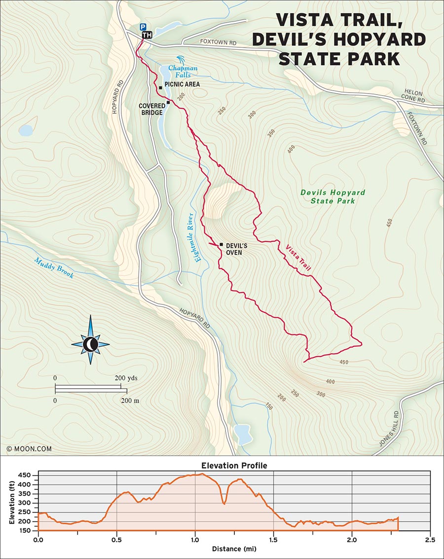
 MILE 0-0.2: Vista Trail Parking Area to Picnic Area and Covered Bridge
From the parking area, cross Foxtown Road and head straight south toward Chapman Falls. The best viewing area for the majestic falls is about 425 feet down the unblazed trail on the left (east). Use caution along the river at the end of the trail, as the rocks can be slick. Backtrack from the viewing area to the main trail, which continues 0.2 mile south into the picnic area, where you’ll find a covered bridge over the river.
 MILE 0.2-0.6: Picnic Area and Covered Bridge to Devil’s Oven
Cross left (east) over the covered bridge and continue straight east on the wide, flat dirt path through low-hanging vegetation. In 0.2 mile, the trail enters a clearing where the sights and sounds of the Eight Mile River pour through huge pine trees. The orange-blazed Vista Trail branches out to both the southeast and southwest. Bear right (southwest) to stay on the west end of the Vista Trail, keeping the river to your right (west). At 0.6 mile, reach an intersection with the side trail for Devil’s Oven.
(Optional: Turn left [east] for a taxing 400-foot climb up to some interesting rock formations, including the Devil’s Oven, a stove-shaped hole in the cliff. Backtrack to the intersection on the same path).
 MILE 0.6-1.0: Devil’s Oven to Vista Lookout Point
From the Devil’s Oven intersection, the orange-blazed Vista Trail continues straight (south), and then bends left (east) away from the river. After a couple of wildflower-dotted stream crossings on log bridges, the path begins to gain elevation. At 0.9 mile, arrive at a hilltop clearing where hikers have built a vast collection of cairns. Continue straight (south) for 0.1 mile to the vista, which looks south into the river valley and takes in the surrounding hills.
 MILE 1.0-1.6: Vista Lookout Point to Vista Trail Intersection
After enjoying the view, backtrack 0.1 mile to the cairns. Here, turn right (east) onto the east end of the Vista Trail to continue the loop. Follow the orange blazes east, then north, on the fern-lined trail as it crosses back over the bubbling streams flowing toward the river. There are some nice ridge views looking over the river along the way. At the intersection at 1.6 miles, turn left (west) to stay on the east end of the Vista Trail.
 MILE 1.6-2.4: Vista Trail Intersection to Chapman Falls and Vista Trailhead
The path descends another 0.3 mile before it reaches the intersection where the east and west ends of the Vista Trail meet. Continue straight north to backtrack the final 0.4 mile to Chapman Falls and the parking area.
From CT-82, turn onto CT-434 and continue north for 3.5 miles. Then, turn right onto Foxtown Road. A large parking/picnic area marked with a sign for Chapman Falls is on the left in 135 feet.
GPS COORDINATES: 41°29'03.6"N 72°20'31.3"W
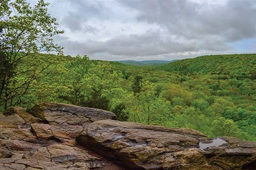
DEVIL'S OVEN VISTA
SLEEPING GIANT STATE PARK, HAMDEN

Climb across a long ridgeline resembling a giant in repose and enjoy stunning views from its summit tower and traprock cliffs.
BEST: Fall hikes
DISTANCE: 4.6 miles round-trip
DURATION: 3 hours
ELEVATION CHANGE: 1,215 feet
EFFORT: Strenuous
TRAIL: Dirt/rock singletrack
USERS: Hikers, leashed dogs
SEASON: April-November
PASSES/FEES: $15 for nonresidents ($7 after 4 pm) on weekends and holidays only.
MAPS: Connecticut DEEP “Sleeping Giant State Park”
CONTACT: Connecticut DEEP State Parks, 860/526-2336
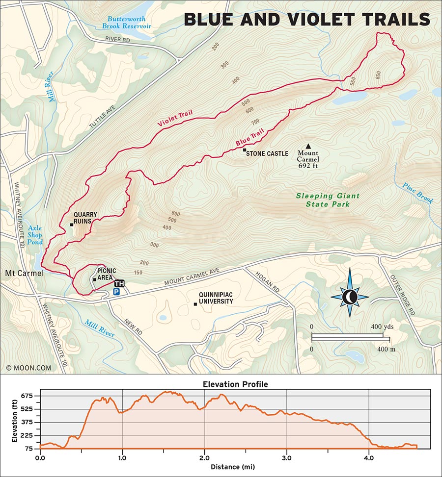
 MILE 0-0.1: Blue Trailhead to Mill River Intersection and Bridge
Follow the paved road northwest from the parking area to the north end of the picnic area loop. From the top of the picnic area loop, follow the blue blazes downhill west for 0.1 mile to the intersection at the Mill River.
 MILE 0.1-0.6: Mill River Intersection and Bridge to Quinnipiac and New Haven Vista
Turn right (north) over the small wooden bridge and continue straight (north) on the blue trail. Ascend the hill and reach the first of many vistas in 0.2 mile. Descend, merging with the red trail for about 100 feet, then turn right (east) up the hill, continuing to follow the blue blazes. The way becomes incredibly steep—almost sheer at times—and hikers may need to use their hands to scramble up for 0.3 mile. At the top of the scramble, there are great vistas looking back to the south and west, taking in Quinnipiac and New Haven.
 MILE 0.6-1.3: Quinnipiac and New Haven Vista to Summit Castle
The path descends for 0.2 mile, first crossing straight east over the red trail, then crossing straight southeast over the Tower Trail. Continue straight (east) uphill on the Blue Trail, cross the red trail and the Tower Trail again in 0.3 mile, then hike 0.2 mile more to reach the stone summit castle, which boosts hikers to incredible views of the valley below. Hikers can see miles of farmland rolling out in all directions below the mountain, as well as Long Island Sound meeting the horizon to the south. There are also restrooms at the summit tower.
 MILE 1.3-2.2: Summit Castle to Violet Trail
From the summit, continue northeast on the Blue Trail for 0.4 mile, then cross straight (east) over the red trail. At the next intersection in 0.4 mile, turn left (northwest) onto the Blue/Violet Connector trail. At the intersection in 0.1 mile, turn left (south) onto the violet-blazed Violet Trail.
 MILE 2.2-4.6: Violet Trail to Picnic Area Loop (and Return to Parking Area)
The Violet Trail bends around the north flank of the Giant, crossing over the red trail four times and passing an old quarry before it meets the edge of the Mill River in 1.8 miles. Follow the violet blazes southeast along the river for 0.3 mile until you reach the paved picnic area loop. Continue straight east on the paved loop to return to the parking area in 0.2 mile.
Note: Sleeping Giant State Park was devastated by a tornado in 2018. The park and trails are undergoing maintenance and specific trail directions may have changed since the time of this writing.
From Hamden, take CT-10 N for 2.6 miles and then turn right onto Mount Carmel Avenue. The park entrance/parking lot is marked with a large sign on the left in 0.3 mile.
GPS COORDINATES: 41°25'21.4"N 72°54'02.4"W
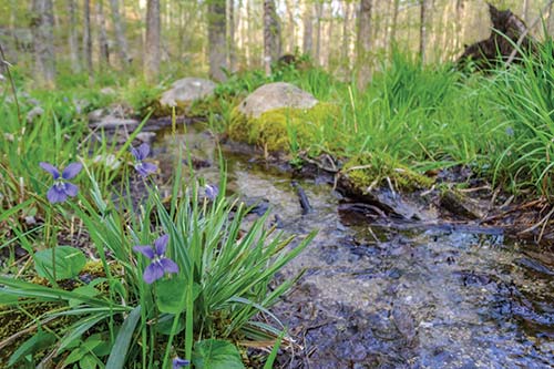
VIOLETS ALONG THE BLUE TRAIL
TALCOTT MOUNTAIN STATE PARK, SIMSBURY

Hike a popular gravel trail to great views from the Heublein Tower and the surrounding traprock cliffs.
DISTANCE: 2.4 miles round-trip
DURATION: 1 hour
ELEVATION CHANGE: 403 feet
EFFORT: Easy/moderate
TRAIL: Gravel road, dirt/rock singletrack
USERS: Hikers, leashed dogs
SEASON: April-November
PASSES/FEES: None
MAPS: Connecticut DEEP, “Talcott Mountain State Park”
CONTACT: Connecticut DEEP State Parks, 860/526-2336
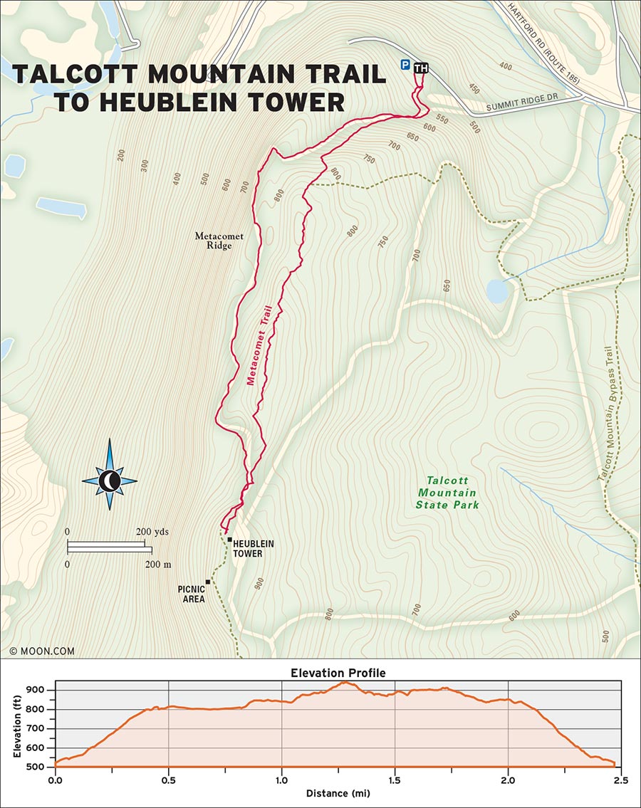
 MILE 0-1.1: Heublein Tower Trailhead Parking Lot to Metacomet Trail
Follow “tower” signs from the parking lot onto a wide gravel path with yellow blazes. The route winds steadily uphill, passing several benches available for rest breaks. Arrive at the edge of a traprock ridgeline in 0.4 mile and turn left (south) for views of the river cutting through the fields below. Continue straight (south) onto the main yellow-blazed path for 0.6 mile as it swoops away from the ridgeline and into a shady corridor of large oaks. Pass under a ledge in 0.1 mile, shortly after which the path merges with the Metacomet Trail.
 MILE 1.1-1.3: Metacomet Trail to Heublein Tower and Summit
Turn right (south) to follow the blue and yellow blazes. At the sign for the tower in 0.1 mile, turn right (south) up the hill on the blue-and-yellow-blazed path. Follow a set of stone steps between the gate and the ledges, and reach the Heublein Tower and picnic area in 0.1 mile. This Bavarian-inspired former summer home of a food and drink magnate provides panoramic views of the Hartford skyline and the Farmington River. Due to the easy access and stunning scenery, the summit can be quite crowded during peak hours. Those in search of solitude can return via the Metacomet Trail.
 MILE 1.3-1.5: Heublein Tower and Summit to Metacomet Trail
Backtrack north for 0.2 mile following the blue and yellow blazes to the intersection where the yellow trail and the Metacomet Trail split. Bear right (northeast) onto the Metacomet Trail.
 MILE 1.5-2.4: Metacomet Trail to Heublein Tower Trailhead Parking Lot
Carry along a hemlock-lined ridge for 0.2 mile to arrive at a secluded grassy knoll. This ridge, with great views looking west over the river valley, is covered in violets in spring and blueberries in summer. Descend following the blue blazes until you reach the intersection with the main yellow-blazed trail in 0.4 mile. Turn right (east) to follow the main trail 0.3 mile back to the parking area.
From Simsbury/US-202, go south then turn left onto CT-185 East/Hartford Road. In 1.5 miles, turn right onto Summit Ridge Drive at the signs for Talcott Mountain State Park. Free parking for the trailhead is marked with trail signs for the tower in 80 feet.
GPS COORDINATES: 41°50'17.8"N 72°47'26.4"W
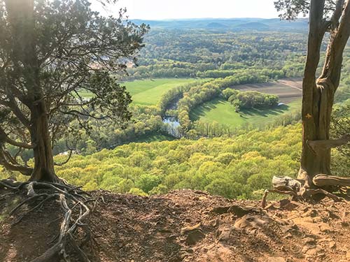
TALCOTT MOUNTAIN RIDGELINE
MASHAMOQUET BROOK STATE PARK, POMFRET

Amble around a bubbling brook to several interesting rock formations including a legendary wolf’s den and a natural granite “chair.”
BEST: Spots for a swim, New England oddities
DISTANCE: 4.4 miles round-trip
DURATION: 2.5 hours
ELEVATION CHANGE: 650 feet
EFFORT: Easy/moderate
TRAIL: Dirt/rock singletrack
USERS: Hikers, leashed dogs, horseback riders
SEASON: April-November
PASSES/FEES: None
MAPS: Connecticut DEEP, “Mashamoquet State Park”
CONTACT: Connecticut DEEP State Parks, 860/526-2336

 MILE 0-0.7: Mashamoquet Brook Bridge to Meadow
Cross the Mashamoquet Brook on the wooden bridge just to the west of the parking area and bear left (southwest) following signs for “Hiking Trails.” Follow the yellow blazes upslope and meet the blue trail in 0.2 mile. Turn right (south) onto the blue trail, which crosses a bridge over another brook in 0.1 mile. Wind through a green forest of deciduous trees and lush ferns for 0.4 mile and arrive on the left (west) side of a meadow dotted with wildflowers—a great spot for bird-watching.
 MILE 0.7-1.7: Meadow to Wolf Den
From here, the trail cuts through a stand of mountain laurel. Arrive at a dirt road in 0.7 mile. Continue across and to the right (west) toward the “Wolf Den Entrance” sign. Follow the dirt road north through the parking and picnic area for 0.2 mile, after which the singletrack trail resumes. Bear right (south) toward signs for “Wolf Den/Indian Chair” and follow the red and blue blazes. The trail continues downhill on a series of stone steps and arrives at the Wolf Den—a narrow cave where Connecticut’s last wolf lived and was killed—in 0.1 mile.
 MILE 1.7-2.1: Wolf Den to Indian Chair
From here, the trail descends in and out of ledges and then crosses a footbridge over a stream. At the intersection in 0.4 mile, continue straight (east) on the blue trail. Shortly after, the trail arrives at the Indian Chair, a bench-like granite structure overlooking the forest floor from atop a ledge. The boulder’s perfect positioning is a coincidence caused by glacial movements, but it is a great spot to stop for a snack and enjoy the views.
 MILE 2.1-3.1: Indian Chair to Wolf Den Camping Area
From the Indian Chair, the trail descends through a swampy area, crosses a wooden bridge, and then wanders up to a ridgeline crisscrossed with stone walls. In about 1 mile, the trail meets the road to the Wolf Den camping area, surrounded by field and meadow. There are also restroom facilities.
 MILE 3.1-4.4: Wolf Den Camping Area to Blue Trail Parking Lot
Turn left (west) onto the road, exit the gate, and then cross the paved road onto the trail in 0.1 mile. This flat section of trail curls around stone walls and streams on all sides. At the intersection in 0.5 mile, turn right (north) to follow the red and blue blazes for 0.4 mile. Bear right (northwest) again to follow the blue blazes for 0.1 mile, then meet the yellow trail. Turn right (north) to follow the yellow trail 0.2 mile back to the parking area.
Take US-44 though Pomfret and continue west; 3.5 miles from town, a large sign on the left marks the entrance to the state park. Continue straight for 0.2 mile to reach the trailhead parking area near the bridge.
GPS COORDINATES: 41°51'28.7"N 71°58'50.0"W
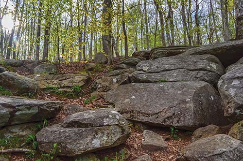
WOLF DEN
| NEARBY CAMPGROUNDS | ||||
|---|---|---|---|---|
| NAME | LOCATION | FACILITIES | SEASON | FEE |
| Devil’s Hopyard State Park | 366 Hopyard Rd., East Haddam, CT 06423 | 21 RV/tent sites; restrooms | mid-April-early September | $24 |
| 860/526-2336, https://www.ct.gov/deep/cwp/view.asp?a=2716&q=325188 | ||||
| Black Rock State Park | 2065 Thomaston Rd., Watertown, CT 06795 | 78 RV/tent sites, 4 cabins; restrooms | late May-early September | $17-60 |
| 860/283-8088, https://www.ct.gov/deep/cwp/view.asp?a=2716&q=325176#directions | ||||
| Kettletown State Park | 1400 Georges Hill Rd., Southbury, CT 06488 | 61 RV/tent sites, 6 cabins; restrooms | late-May-early September | $27-60 |
| 203/264-5678, https://www.ct.gov/deep/cwp/view.asp?a=2716&q=325034&deepNav_GID=1621#kettletown | ||||
| Mashamoquet Brook State Park | 276 Mashamoquet Rd., Pomfret Center, CT 06259 | 53 RV/tent sites; restrooms | late May-early September | $24 |
| 860/928-6121, https://www.ct.gov/deep/cwp/view.asp?a=2716&q=325238 | ||||