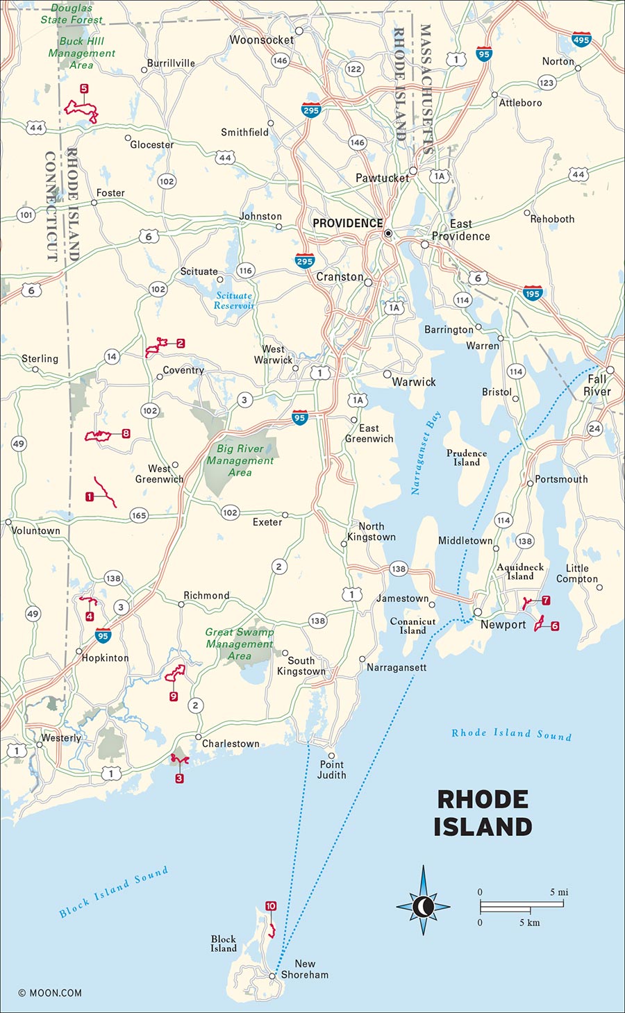
From offshore Block Island to the Narragansett Bay, Rhode Island’s vast sandy beaches, imposing clay cliffs, and swaying grasses are a dream for boaters, birders, and hikers. Inland, the state’s kettle ponds, erratic rocks, and vibrant plant life are just as alluring. The hikes here are not particularly steep or challenging, but the scenery along these trails is key to understanding the diversity of New England’s southeastern landscape, which can fluctuate from gentle and subdued to jagged and dramatic with the turn of a corner. Nowhere is this more true than tiny, watery Rhode Island, which is guaranteed to enchant in spite of its size.
1 North South Trail to Stepstone Falls, Arcadia Management Area
2 Coventry and Foster Loops, George B. Parker Woodland Wildlife Refuge
3 Foster Cove, Cross Refuge, and Grassy Point Trails, Ninigret National Wildlife Refuge
4 Long and Ell Pond Trail, Rockville Management Area
5 Walkabout Trail, George Washington Management Area
6 Flint Point and Ocean View Loops, Sachuest Point National Wildlife Refuge
7 Nelson Pond Trail, Norman Bird Sanctuary
8 Pond, Coney Brook, and Flintlock Loops, Tillinghast Pond Management Area
9 Grassland, Moraine, and Old Pasture Loops, Francis C. Carter Memorial Preserve
10 Clay Head and The Maze Trails, Clay Head Preserve

ARCADIA MANAGEMENT AREA, EXETER

This hidden gem in the Arcadia Management Area features a waterfall and a pleasant walk along the banks of the Falls River, where a variety of rare wildflowers grow.
BEST: Spring hikes, brew hikes
DISTANCE: 5.6 miles round-trip
DURATION: 3.7 hours
ELEVATION CHANGE: 312 feet
EFFORT: Easy
TRAIL: Dirt path
USERS: Hikers, leashed dogs (horseback riders, mountain bikers permitted on some sections)
SEASON: Year-round
PASSES/FEES: Free
MAPS: RI Department of Environmental Management, “Arcadia Management Area North—Rt. 165.”
CONTACT: RI Division of Parks and Recreation, 401/539-2356
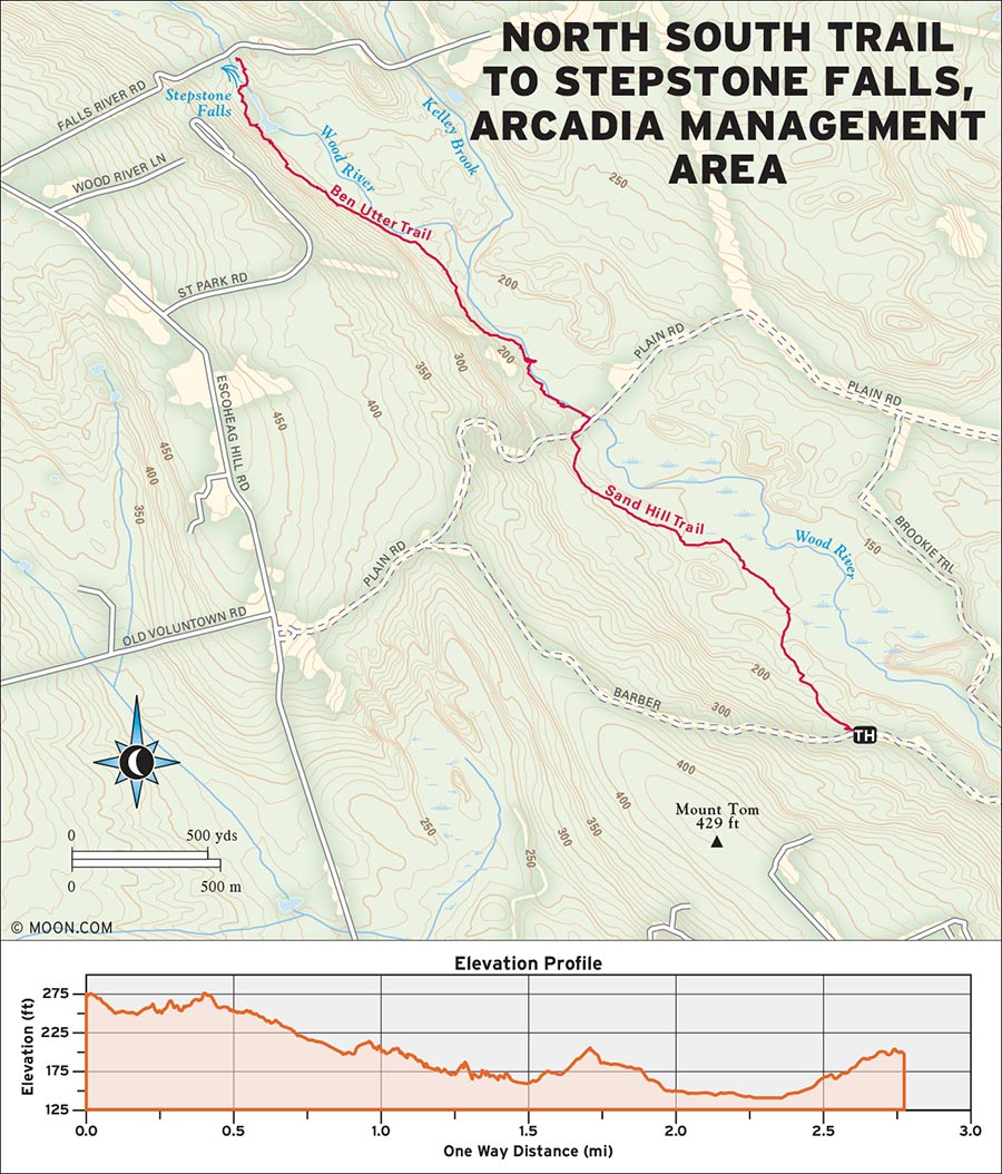
Rhode Island’s North South Trail stretches 78 miles across the state, and this segment through the Arcadia Management Area is one of the most scenic and unspoiled sections, traveling on secluded footpaths through the heart of the park. It’s a gentle trail, but rare plant life, a rushing river, and a series of uniquely shaped falls make this hike feel truly wild.
 MILE 0-1.2: North South Trailhead to Austin Farm Road
Heading right (east) from the trailhead, follow the blue-blazed North South Trail from where it splits from Barber Road. From the marshy meadow off Barber Road, the narrow trail bends into a secluded pine grove on a flat, winding track. Boardwalks assist hikers through muddy portions, and blueberries are prevalent along the trailside. Pass the Spur Trail, the Sand Hill Trail, and the Escoheag Trail, keeping right to stay on the well-marked North South Trail. Arrive at Austin Farm Road at 1.2 miles.
 MILE 1.2-2.4: Austin Farm Road to Wooden Bridge
Cross to the right (east) side of the road, then take a left (north) just before the bridge. Here, the North South Trail merges with the yellow-blazed Ben Utter Trail and heads north upstream along the river. (The following length of trail, approximately 1 mile, is truly spectacular, with crafted footbridges, rushing water, and blossoms of rare wildflowers, such as pink lady’s slippers and azaleas along the riverbanks.)
At 0.5 mile from the start of the Ben Utter Trail, reach a dirt road and turn right (east) to stay on the blue-blazed trail. At the fork in 0.6 mile, bear right (east) again to stay on the North South trail. The trail becomes rocky as the river widens through swampland. Arrive at a wooden bridge across the river at 2.4 miles.
 MILE 2.4-5.6: Wooden Bridge to Stepstone Falls
Turn right (east) onto the bridge, then turn immediately left (north) to follow the river upstream. In 0.2 mile, reach Stepstone Falls, a cascade over a series of square-shaped boulders. Backtrack from the falls for a 5.6-mile round-trip.
From RI-3 or I-95, take RI-165 W (Ten Rod Road). Turn right into the Midway parking area and continue north on the dirt road, following the blue blazes of the North South Trail. In 0.5 mile, turn left over the bridge onto Barber Road and follow it for 0.9 mile. Park at the turnoff where the North South Trail splits into the woods on the right.
GPS COORDINATES: 41°35'07.9"N 71°44'02.5"W
GEORGE B. PARKER WOODLAND WILDLIFE REFUGE, COVENTRY

With stone walls, historic sites, and enormous glacial erratic rocks, this hike in and around a bubbling brook is a pleasant setting for birding and wildlife viewing.
DISTANCE: 6 miles round-trip
DURATION: 4 hours
ELEVATION CHANGE: 611 feet
EFFORT: Easy
TRAIL: Dirt path, boardwalk
USERS: Hikers only
SEASON: Year-round
PASSES/FEES: Free
MAPS: Audubon Society of Rhode Island “George B. Parker Woodland Wildlife Refuge”
CONTACT: Audubon Society of Rhode Island, 401/295-8283, http://asri.org
 MILE 0-0.5: Trailhead Parking Lot to Coventry Loop
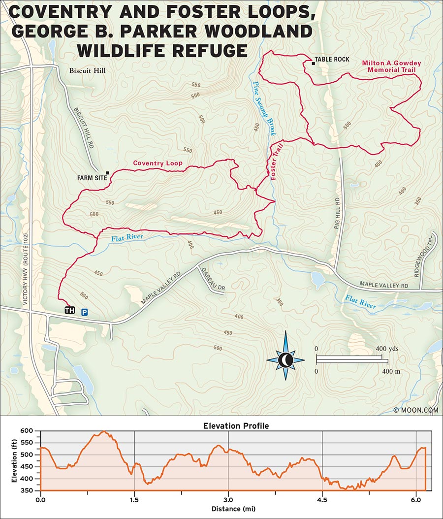
Hikers can enjoy the warbles and twitters of birds in the greenery while traversing long boardwalks through wetlands, exploring gigantic boulders along a brook, or seeking out deer on the edge of a pastoral meadow. The trail heads north out of the parking lot. Take a left (west) toward the meadow at the sign and follow the path through a grassy field, a great spot for wildlife viewing when quiet. Continue along the orange-blazed trail as it enters the woods and reaches an intersection at 0.2 mile. Stay straight (north) on the orange trail, which bounds over a series of long boardwalks and bog bridges. Reach the intersection with the blue-blazed Coventry Loop in 0.3 mile.
 MILE 0.5-0.8: Coventry Loop to Foster Loop
Turn left (west) onto the Coventry Loop to complete the circuit clockwise. The path winds along stone walls, through a beech and oak forest, and passes the historic Vaughn Farm site. After descending past several overhanging ledges, the rolling trail arrives at a massive boulder at 0.8 mile, where a sign marks the yellow-blazed connector trail leading toward the Foster Loop.
 MILE 0.8-1.6: Foster Loop to Milton A. Gowdey Memorial Trail
Turn left (northeast) and follow the yellow blazes, which trek through a boulder field and along the stream. The yellow connector trail reaches the Milton A. Gowdey Memorial Trail/Foster Loop (marked with blue blazes) at 1.6 miles.
 MILE 1.6-4.2: Milton A. Gowdey Memorial Trail to Coventry Loop
Turn left (north) onto this blue-blazed loop, which rolls through an enormous field of blueberries, descends in and out of a brook valley, and passes the flat granite slab known as Table Rock. The trail crosses a dirt road and goes through a gate in 2 miles; it returns to the junction with the connector trail 0.2 mile later. Take a left (west) and follow the yellow-blazed trail 0.4 mile back to the intersection with the large boulder.
 MILE 4.2-6.0: Coventry Loop to Trailhead Parking Lot
Turn left (south) around the boulder to join with the other end of the blue-blazed Coventry Loop. This section of trail travels along the brook banks for about 1 mile before reaching an intersection with the path toward Parking Lot 2. Stay straight on the blue-blazed trail toward Parking Lot 1, which passes a collection of more than 100 historic stone cairns. Reach the intersection with the orange trail in another 0.3 mile, and turn left (south) onto the orange trail back toward the lot.
From West Greenwich, head north on RI-102 (Victory Highway) for 6.5 miles, then turn right onto Maple Valley Road. The well-marked gated parking area is 0.1 mile down the road on the left.
GPS COORDINATES: 41°43'00.1"N 71°41'53.0"W
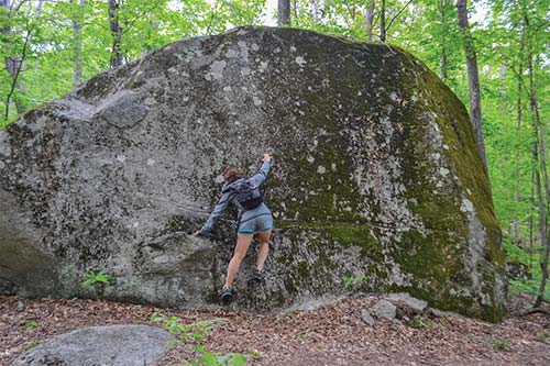
BOULDER AT THE COVENTRY LOOP AND FOSTER LOOP INTERSECTION
NINIGRET NATIONAL WILDLIFE REFUGE, CHARLESTOWN

Hike on this gentle grass and gravel track to a scenic barrier beach where shorebirds and wildflowers flourish.
BEST: New England oddities, brew hikes
DISTANCE: 4.5 miles round-trip
DURATION: 2 hours
ELEVATION CHANGE: 22 feet
EFFORT: Easy
TRAIL: Grass/gravel path
USERS: Hikers, bikers
SEASON: Year-round
PASSES/FEES: None
MAPS: U.S. Fish and Wildlife Service, “Ninigret National Wildlife Refuge Salt Pond Unit”
CONTACT: U.S. Fish and Wildlife Service Ninigret Refuge Headquarters, 401/364-9124, http://fws.gov/refuge/Ninigret
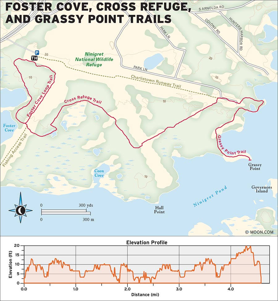
 MILE 0-0.5: Trailhead to Cross Refuge Trail
From the trailhead sign, go right (west) onto the Foster Cove Loop, a wide grass and gravel track surrounded by thick vegetation and perfumed with honeysuckle. The flat and easy trail arrives at water views of Foster Cove in 0.2 mile. Reach an intersection 0.3 mile farther on the trail.
 MILE 0.5-1.6: Cross Refuge Trail to Auxiliary Air Station Runway
Stay straight (south) for the Cross Refuge Trail, which crosses over a strip of pavement and returns to a gravel surface. The trail slips between two lily pad-laden bogs. At the gated intersection at 1.3 miles, bear left (east). The vegetation opens into a spacious, grassy habitat where wildflowers and birds abound. Reach the parking area at 1.6 miles, and walk right (east) through the lot to the site of an old runway from Ninigret’s days as Naval Auxiliary Air Station Charlestown.
 MILE 1.6-1.8: Auxiliary Air Station Runway to Grassy Point Trail
The trail continues on the far east side of the runway. Turn left (northwest) onto the Grassy Point Trail, which passes into the woods and then hugs the edge of Ninigret Pond, with great water views. After 0.2 mile, cross the bridge and then turn left (south) to follow the grassy trail to the end of the point.
 MILE 1.8-2.6: Grassy Point Trail to Cross Refuge Trail
At the trail’s terminus in 0.5 mile, you can enjoy more water views and wildlife from the observation deck. Backtrack 0.3 mile to the intersection and turn left (west), following signs for the Cross Refuge Trail.
 MILE 2.6-4.5: Cross Refuge Trail to Foster Cove Loop
Turn left (southwest) again onto the Cross Refuge Trail at 2.8 miles, and backtrack to the Foster Cove Loop in 1.1 miles. For variety, you can turn right onto the eastern side of the Foster Cove Loop and hike 0.6 mile to return to the lot.
From US-1, use the large brown signs to navigate to the West Entrance of the refuge, which is directly off the highway. Those coming from the north should pass the entrance and then double back onto US-1 N at Wildflower Road. There is a large parking lot at the trailhead.
GPS COORDINATES: 41°22'05.9"N 71°40'19.6"W
ROCKVILLE MANAGEMENT AREA, HOPKINTON

The trail to Long Pond is like a natural playground—there are boulders to scramble over, stairs to climb, bridges to cross, and some of the most spectacular inland views in Rhode Island.
BEST: Vistas
DISTANCE: 4.4 miles round-trip
DURATION: 2.5 hours
ELEVATION CHANGE: 405 feet
EFFORT: Easy/moderate
TRAIL: Dirt/rock path
USERS: Hikers, leashed dogs
SEASON: April-November
PASSES/FEES: None
MAPS: Audubon Society of Rhode Island, “Long Pond Woods”
CONTACT: Audubon Society of Rhode Island, 401/949-5454, http://asri.org
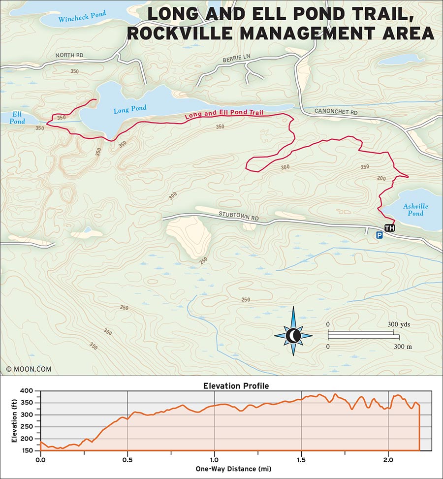
Movie buffs might recognize sections of the Narragansett Trail to Long Pond from the 2012 Wes Anderson film Moonrise Kingdom. It’s no wonder Anderson chose this scenic trail as his set—its large granite boulders make for fun scrambles and picture-perfect vistas. This route begins on the south side of the Rockville Management Area before wrapping around Asheville Pond and climbing steadily to the overlook above Long Pond.
 MILE 0-0.5: Trailhead to Canonchet Road Parking Area
Hike north from the trailhead toward Asheville Pond. The dirt trail winds along the west edge of the pond and continues north for 0.5 mile. Here the trail bends sharply right (east), then wraps to the west, and then switchbacks east again through a tunnel of giant laurel bushes.
 MILE 0.5-1.5: Canonchet Road Parking Area to Valley
Pass the Canonchet Road parking area at 1.2 miles and turn left (west). The trail gains elevation along a rock ridge, passes a pair of huge boulders, and follows a stone wall west for about 0.3 mile. As the trail reaches the top of a hill, the waters of Long Pond peek out from beyond the trees. The trail then leads hikers down through a pile of boulders and into a green valley.
 MILE 1.5-1.9: Green Valley to Long Pond Overlook
Past the valley, make a steep ascent to the top of a ridge. The trail continues to ascend and descend for 0.3 mile before skirting the east edge of a root-bound hill. At the bottom of the hill, go down the stairs and cross the long wooden bridge through a cedar bog. At the other end of the bridge, climb through a final steep corridor of rock to arrive at an intersection at 1.9 miles. Go straight (north) through the intersection for the trail leading to Long Pond overlook.
 MILE 1.9-2.2: Long Pond Overlook to Summit
The path passes several rock outcroppings and then descends a hill. It reaches a towering rock formation at 2.1 miles. Follow the trail around to the north side of the rocks. At the “End of Trail” sign, ascend to the right, up the east side of the formation. Reach the “summit” of the rocks at 2.2 miles for vast views of Long Pond below. Backtrack on the same trail to return to the lot.
From RI-3, turn north onto Canonchet Road. Then turn left onto Stubtown Road. The Asheville Pond parking area is marked with a Rockville Management Area sign.
GPS COORDINATES: 41°29'59.4"N 71°45'37.4"W
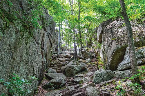
CLIFFS AT LONG POND
GEORGE WASHINGTON MANAGEMENT AREA, CHEPACHET

Built by a group of Australian sailors in 1965, the Walkabout Trail is a secluded loop through woods and around sparkling lakes.
BEST: Spots for a swim, New England oddities
DISTANCE: 7.8 miles round-trip
DURATION: 3.75 hours
ELEVATION CHANGE: 375 feet
EFFORT: Easy/moderate
TRAIL: Dirt/rock path
USERS: Hikers, leashed dogs, horseback riders
SEASON: Year-round
PASSES/FEES: $2 per vehicle daily visitors pass
MAPS: Rhode Island Division of Parks and Recreation, “George Washington/Pulaski Wildlife Management Area”
CONTACT: Rhode Island Division of Parks and Recreation, 401/568-2085, http://riparks.com
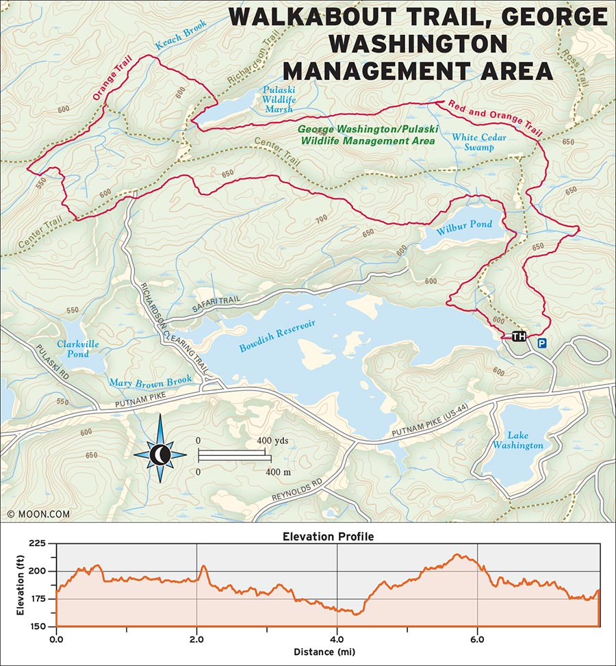
 MILE 0-3.3: Bowdish Reservoir Beach to Pulaski Management Area
Start at the Bowdish Reservoir beach and hike north, following the trail with orange, red, and blue blazes into the woods. The muddy path traces the edge of the lake, highlighting unspoiled waterfront and enormous granite boulders. The trail bends east toward Wilbur Pond in 0.4 mile. Cross the road and continue straight east in 0.3 mile. The blue trail branches off to the east at 0.8 mile. Turn left (north) to follow the orange and red blazes around Wilbur Pond. At the next intersection at 2.0 miles, turn left (west) to follow only the orange blazes. The trail crosses straight across several dirt roads and through a hemlock grove. At the intersection at 3.3 miles, follow the orange blazes straight (north) downhill. Cross a long wooden footbridge and enter Pulaski Management Area.
 MILE 3.3-4.5: Pulaski Management Area to Pulaski Wildlife Marsh
Just after the sign, turn right (northeast) and continue to follow the orange blazes through a wetland area along a stream. At 4.5 miles, the trail crosses another dirt road and arrives at the Pulaski Wildlife Marsh.
 MILE 4.5-7.8: Pulaski Wildlife Marsh to North South Trail
Continue south along the edge of the marsh. At the southwest edge of the marsh, turn left (east) and follow signs for the North South Trail across the levee bridges and into the woods. Turn left again to stay on the orange-blazed North South Trail heading north. The trail winds through a swamp, merging with the red trail at 5.1 miles. Follow the orange and red blazes east through a muddy cedar swamp with plenty of interesting log bridges to help your footing. The path joins the blue trail in 1.5 miles. Keep straight, following the red, orange, and blue blazes south for 1.2 miles back to the beach.
From Glocester, take US-44 (Putnam Pike) west and turn right (north) into the well-signed George Washington State Campground and Management Area. After checking in at the gate, continue north to the parking area/restrooms near the Bowdish Reservoir beach.
GPS COORDINATES: 41°55'11.4"N 71°45'17.9"W
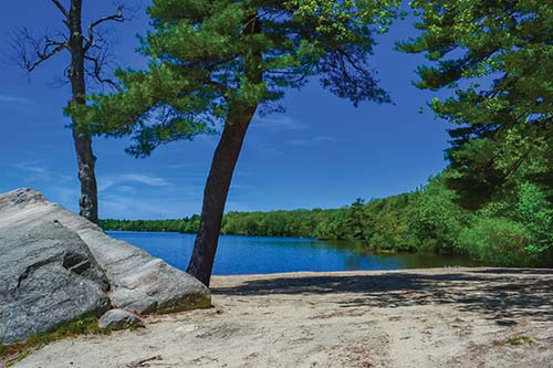
BOWDISH RESERVOIR BEACH
SACHUEST POINT NATIONAL WILDLIFE REFUGE, MIDDLETOWN

Enjoy miles of waterfront views on this easy trail that winds between golden fields and a rocky peninsula jutting into the Atlantic Ocean.
BEST: Summer hikes, brew hikes
DISTANCE: 2.5 miles round-trip
DURATION: 1.25 hours
ELEVATION CHANGE: 53 feet
EFFORT: Easy
TRAIL: Gravel path
USERS: Hikers
SEASON: Year-round
PASSES/FEES: None
MAPS: U.S. Fish and Wildlife Service, “Sachuest Point National Wildlife Refuge”
CONTACT: U.S. Fish and Wildlife Service, 401/619-2680, http://fws.gov
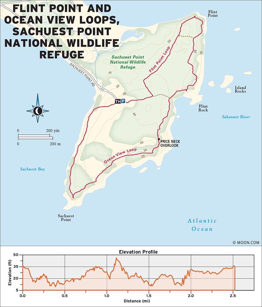
Situated on a peninsula just east of Newport, the 242-acre Sachuest Point refuge is both a destination for migratory shorebirds and a prized fishing area. Our route follows the park’s two main trails—Flint Point and Ocean View—which follow the coastline on an easy gravel track featuring observation platforms, grassy bird habitat, and a hypnotizing jagged shoreline.
 MILE 0-0.6: Trailhead to Flint Point Observation Deck
Find the trailhead in the northeast corner of the parking area and head straight east toward the Flint Point Loop on the wide gravel path. In 600 feet, bear left (north) on the Flint Point Loop, which winds through grassland and thick vine before arriving at ocean views. Reach the Flint Point observation deck at 0.6 mile, where you can view boats bobbing in the Sakonnet River to the north and east.
 MILE 0.6-1.2: Flint Point Observation Deck to Price Neck Overlook
From here, the path bends east along the coast through wild beach rose and honeysuckle. Shoreline views of sunbathing cormorants and sailboats persist to the east. Reach another observation deck at 1.0 mile. Then, continue straight south onto the Ocean View Loop. Bear right (west) up the stairs at 1.2 miles toward the Price Neck Overlook. This rocky ledge affords panoramic views of the shoreline below.
 MILE 1.2-2.5: Price Neck Overlook to Sachuest Point
The Price Neck path drops back down to the Ocean View Loop at 1.4 miles. Hike right (south), with vast fields to one side and the increasingly dramatic coastline to the other. Reach the tip of Sachuest Point at 1.8 miles. Here, you may want to take some time to explore the rocks before continuing the 0.7 mile on the path north back to the visitors center and parking area.
From US-1, take RI-138 E over the Newport Bridge. Take the Newport exit and pass through downtown Newport on RI-138A. After First Beach, take a right onto Purgatory Road. Then turn right onto Sachuest Point Drive and follow it to Sachuest Point Visitors Center at the very end of the road.
GPS COORDINATES: 41°28'47.4"N 71°14'38.0"W
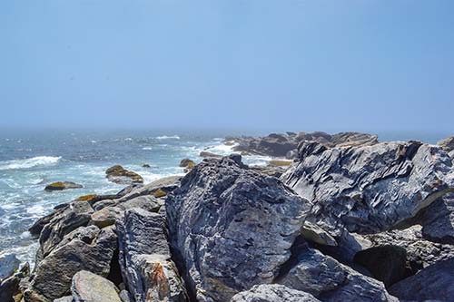
SACHUEST POINT
NORMAN BIRD SANCTUARY, MIDDLETOWN

Bird lovers will delight at the diverse collection of fields, woods, ponds, and ledges at Norman Bird Sanctuary, which attracts a variety of species.
BEST: Vistas
DISTANCE: 2.8 miles round-trip
DURATION: 1.5 hours
ELEVATION CHANGE: 188 feet
EFFORT: Easy/moderate
TRAIL: Dirt/rock path, boardwalk
USERS: Hikers
SEASON: Year-round
PASSES/FEES: $7 adult, $6 senior/military, $3 student/child
MAPS: Norman Bird Sanctuary, “Norman Bird Sanctuary Trail Map”
CONTACT: Norman Bird Sanctuary, 401/846-2577, http://normanbirdsanctuary.org
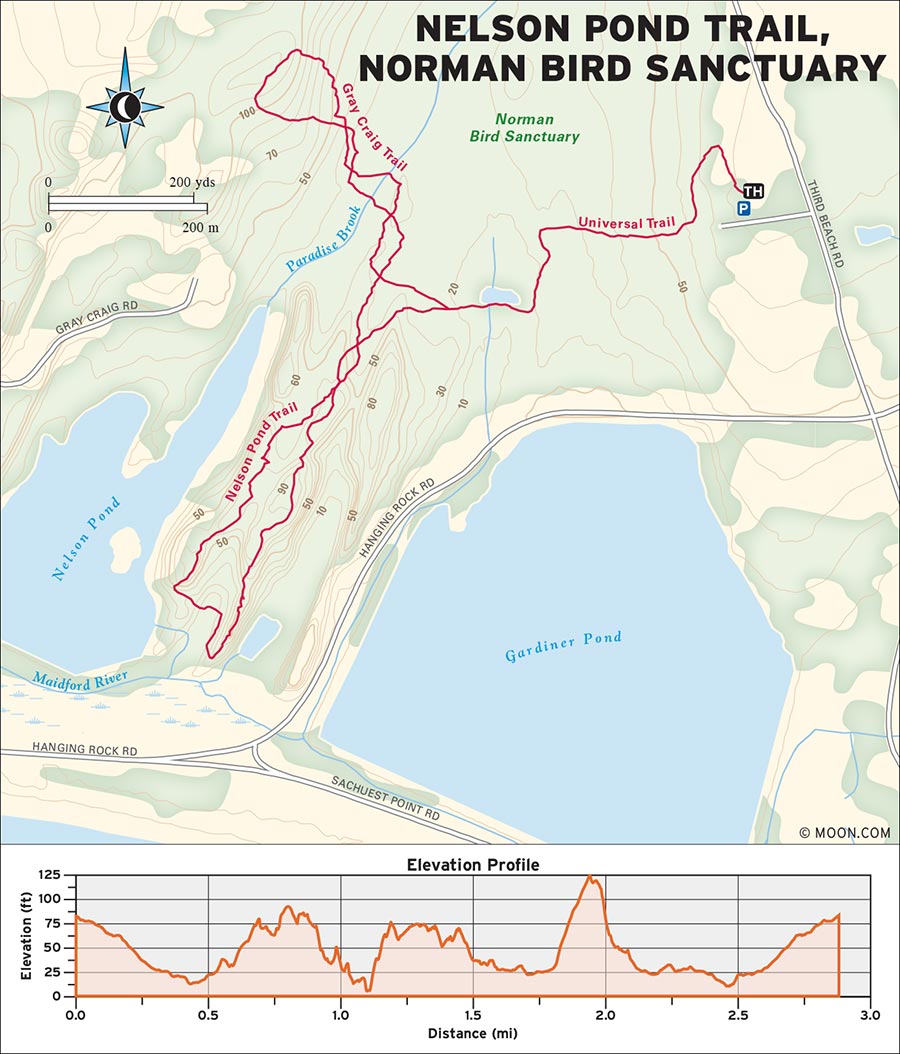
The many trails of Norman Bird Sanctuary offer myriad habitats, but hikers are often most attracted to the park’s “Ridge Trails”—long pudding stone fingers that reach out toward the Atlantic Ocean. To access the ridges, our route follows the main Universal Trail through field, shrub, and forest, and then forms a loop on the Red Fox, Nelson Pond, and Gray Craig Trails.
 MILE 0-0.4: Visitors Center to Red Maple Pond
Check in at the visitors center and then walk north on the Universal Trail through fields and around the garden. Reach an intersection at 0.2 mile and keep right (west) on the gravel path. The trail ventures into shady woods and along a stone wall to reach another intersection at 0.4 mile. Turn left (south) and hike along the long boardwalk, which ends at the observation deck on Red Maple Pond.
 MILE 0.4-0.7: Red Maple Pond to Red Fox Trail
Turn right to head west around the pond and over the bridge. Follow the stone steps for 0.1 mile and then turn left (south). Almost immediately, turn right (west) onto another boardwalk, following signs toward Nelson Pond. Continue to bear right following signs for the Red Fox Trail. Then, at 0.7 mile, bear left (south) onto the Red Fox Trail.
 MILE 0.7-1.1: Red Fox Trail to Red Fox Ridge
The path enters a cool forest protected by massive beech trees and climbs slightly uphill over a series of ledges, with deep green valleys on either side. Reach the end of the Red Fox ridge at 1.1 miles, with great views looking east toward Hanging Rock and south to the ocean.
 MILE 1.1-1.7: Red Fox Ridge to Gray Craig Trail
Descend straight to the south and follow the low, grassy trail for 0.1 mile. Turn left (west) onto the boardwalk then follow the trail left (west) as it climbs the ledges to more great views. The trail continues north on easy terrain, reaching a rocky viewpoint of Nelson Pond at 1.5 miles. Follow the viewpoint trail to the left (west); it descends to the main path at 1.5 miles. At the signed intersection at 1.7 miles, bear left (north) onto the Gray Craig Trail.
 MILE 1.7-2.8: Gray Craig Trail to Universal Trail and Visitors Center
Follow the path through the woods and over another boardwalk, which crosses a marsh brimming with plant life. At 2.1 miles, the trail climbs uphill to another ledge—a great, secluded spot for bird-watching. The narrow path then descends and loops back to its start at 2.3 miles. Turn left (south) and follow signs back toward the visitors center. Turn left (east) over the boardwalk at 2.5 miles on the Ridge Connector Trail. Reach the Universal Trail and turn left (north) to hike 0.3 mile back to the visitors center.
From downtown Newport, follow RI-138A to Purgatory Road. Bear left on Hanging Rock Road and then turn left on Third Beach Road. The well-marked and signed parking lot is on the left. Be sure to check in at the visitors center before hiking the trails.
GPS COORDINATES: 41°29'59.3"N 71°15'00.9"W
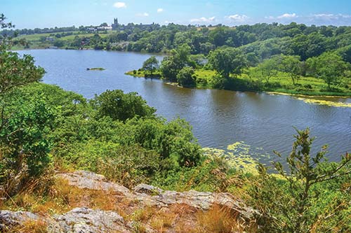
NELSON POND
TILLINGHAST POND MANAGEMENT AREA, WEST GREENWICH

Enjoy views of a pristine pond surrounded by field and forest on the trails of the Nature Conservancy’s largest preserve.
BEST: Winter hikes
DISTANCE: 5.4 miles round-trip
DURATION: 2.75 hours
ELEVATION CHANGE: 204 feet
EFFORT: Easy
TRAIL: Dirt path
USERS: Hikers, paddlers
SEASON: Year-round
PASSES/FEES: None
MAPS: The Nature Conservancy “Tillinghast Pond Management Area”
CONTACT: The Nature Conservancy, 401/331-7110, http://nature.org
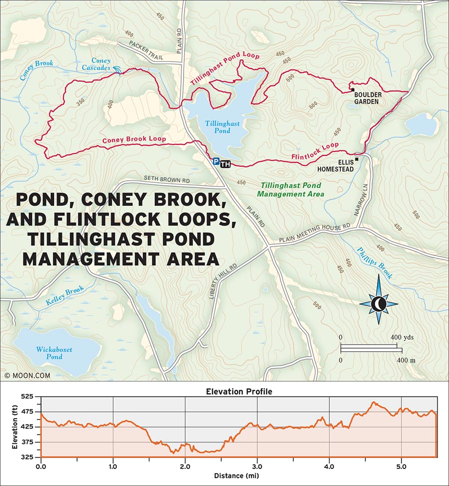
 MILE 0-0.1: Pond Loop Trailhead to Plain Road
Walk to the Pond Loop trailhead at the north corner of the parking lot and hike north, following the white blazes. Turn left (west) onto the orange-blazed Coney Brook Loop at 0.1 mile. The trail crosses straight west over Plain Road, then becomes narrow as it winds through a stand of pines.
 MILE 0.1-1.9: Plain Road to Cascades
Bear left (west) to stay on the orange-blazed Coney Brook Loop at 0.1 mile. The trail opens into a field of blueberries with views of the hills to the west, then turns into the woods after 0.3 mile. Hike along the slopes of a fern-covered mixed forest, then arrive at a frog-filled bog in 0.4 mile. Turn right (north) to stay on the Coney Brook Loop, which reaches Coney Brook at 1.7 miles. Follow the brook and hike east upstream along the gorge, descend the wooden staircase, and cross the bridge to reach a small series of cascades. At the dam, the trail turns right (south) around a pond. The trail may be slightly flooded here. Arrive at an open field of daisies and black-eyed Susans in 0.2 mile.
 MILE 1.9-3.4: Cascades to Flintlock Loop
Continue south along the edge of the field and reach the road in 0.2 mile. Turn left (north) onto the road and find the white-blazed Pond Loop where it enters the forest to the right (east). The Pond Loop trail alternates between fields of hay and the pine-forested shoreline as it traces Tillinghast’s northern shore. Turn left (north) onto the yellow-blazed Flintlock Loop in 1.2 mile.
 MILE 3.4-4.7: Flintlock Loop to Ellis Homestead
The narrow path climbs slightly uphill to a fork in 0.4 mile. Turn right at the fork to follow the south spur to the “Boulder Garden,” where large rocks seem to sprout from tufts of grass. 0.2 mile east of the Boulder Garden, turn right (east) to return to the main Flintlock Loop. At the unsigned intersection with the Wickaboxet Trail at 4.3 miles, turn right (south) to follow the blue and yellow blazes through a corridor of large white pines. The blue-blazed trail diverges in 0.3 mile. Stay straight south, following the yellow-blazed Flintlock Loop, which opens into a grassy clearing and reaches Phillips Brook and the Ellis Homestead at 4.7 miles.
 MILE 4.7-5.4: Ellis Homestead to Pond Loop
Turn right at the homestead and follow the narrow trail west through thick growth. At 4.8 miles, the path passes the Ellis Family Cemetery. Continue west for 0.4 mile to the intersection with the Pond Loop. Hike straight west, following the white blazes between the pond and a stone wall for 0.2 mile back to the parking area.
From West Greenwich on RI-102, turn left onto Plain Meetinghouse Road. At the four-way intersection, turn right onto Plain Road and continue for 0.5 mile. The large parking area on the right is marked with a Nature Conservancy sign and trailhead kiosk.
GPS COORDINATES: 41°38'47.2"N 71°45'28.7"W
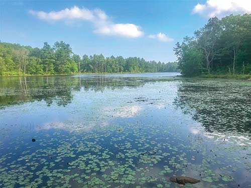
TILLINGHAST POND
FRANCIS C. CARTER MEMORIAL PRESERVE, CHARLESTOWN

This peaceful woodland trail is punctuated by vernal pools, historic stonework, and open grasslands that attract diverse bird species.
DISTANCE: 4.4 miles round-trip
DURATION: 2 hours
ELEVATION CHANGE: 227 feet
EFFORT: Easy
TRAIL: Dirt/grass path
USERS: Hikers, horseback riders
SEASON: Year-round
PASSES/FEES: None
MAPS: The Nature Conservancy “Carter Preserve Trail System”
CONTACT: The Nature Conservancy, 401/331-7110, http://nature.org
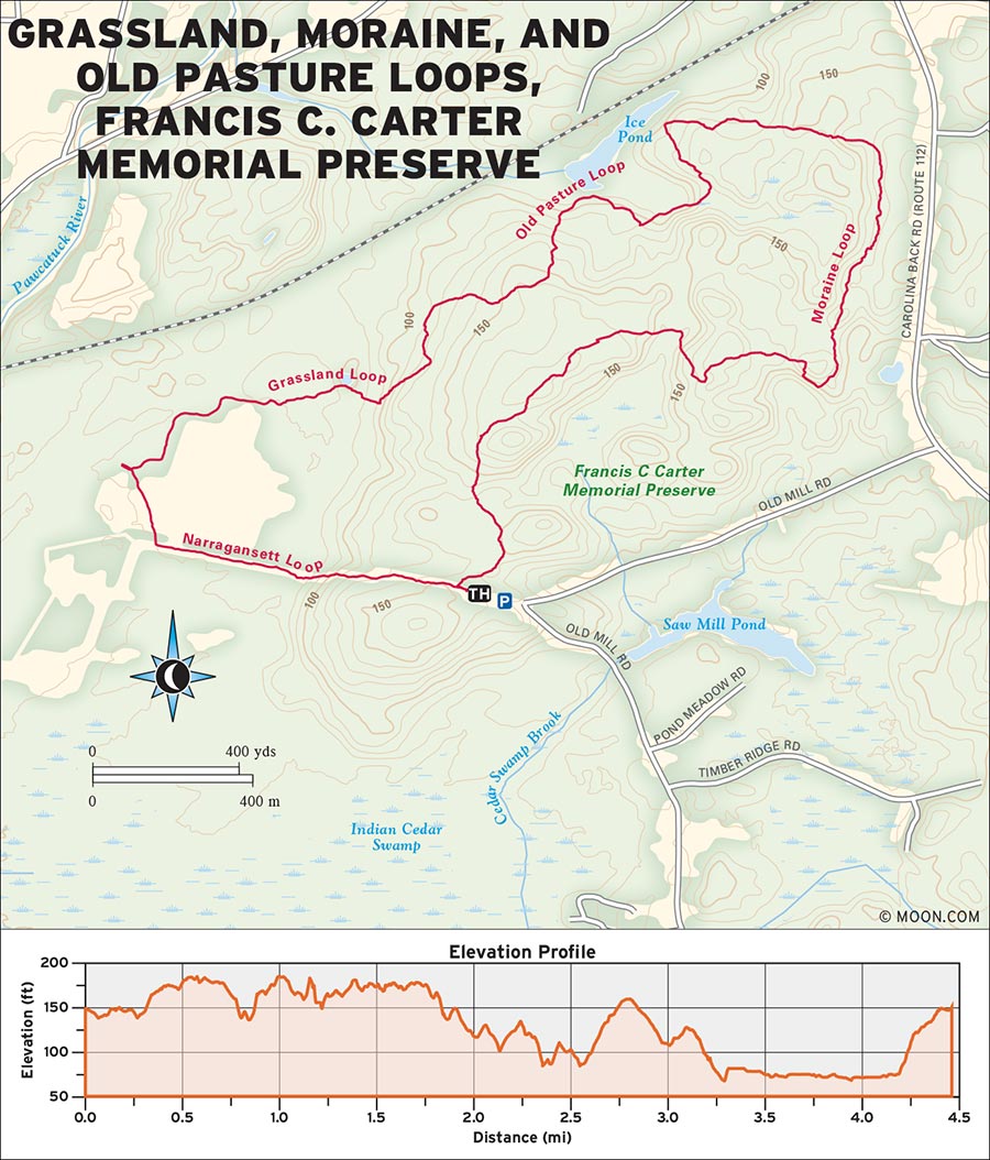
 MILE 0-0.3: Trailhead to Old Pasture Loop
Head straight west from the trailhead on a wide grass path; turn right (north) onto the yellow-blazed Grassland Loop in 135 feet. The narrow, flat trail is lined with heavy vegetation, and it’s a great place to pick blueberries along the way in season. At the intersection at 0.3 mile, turn right (north) onto the blue-blazed Old Pasture Loop trail.
 MILE 0.3-0.9: Old Pasture Loop to Moraine Loop
Cross the stone wall and then follow alongside it in a black oak forest dotted with fern and pitch pine. Reach a fork in another 0.3 mile and keep right (east) on the blue-blazed trail. When you reach the large boulder and intersection with the Moraine Loop at 0.9 mile, turn right (south) to follow the orange blazes.
 MILE 0.9-3.0: Moraine Loop to Grassland Loop
The trail climbs slightly uphill to the south before bending back northwest. At the intersection with the Split Rock Loop at 1.2 miles, stay left (east) on the orange-blazed trail. Pass the other end of the Split Rock Trail at 1.6 miles, then another spur trail at 2.2 miles, keeping left (north) at both intersections. Continue on the Moraine Loop and pass several giant boulders and a stone wall, then cross over the historic dam at 2.7 miles. Reach the intersection with the Old Pasture Loop and bear right (north) to follow the blue blazes. The trail winds along a bog and through a patch of tall ferns before it reaches the intersection with the Grassland Loop at 3.0 miles.
 MILE 3.0-4.4: Grassland Loop to Trailhead
Turn right (north) onto the yellow-blazed trail, which passes the bog and winds left uphill to a bench. The trail here can sometimes be brushy and overgrown, but it shortly emerges in an open field at 3.2 miles. At the field, turn right (west) onto the grass path and follow it along the northern border of the meadow. When you reach the intersection with the Narragansett Loop at 3.7 miles, keep left on the Grassland Loop, which eventually enters a pitch pine forest and leads straight southeast back to the parking area in 0.7 mile.
From I-95, take exit 3 to RI-138 E and follow it to the intersection with RI-112. Follow RI-112 past a sign for Carter Preserve and take the next right onto Old Mill Road. At the next Carter Preserve sign, bear right onto the dirt road and follow it to the large parking area at the end of the drive.
GPS COORDINATES: 41°25'33.2"N 71°39'46.8"W
CLAY HEAD PRESERVE, NEW SHOREHAM, BLOCK ISLAND

Explore Block Island’s sentinel cliffs from this ambling seaside path with beach access and a labyrinth of unmarked trails.
BEST: Summer hikes, spots for a swim
DISTANCE: 2.9 miles round-trip
DURATION: 2 hours
ELEVATION CHANGE: 114 feet
EFFORT: Easy
TRAIL: Dirt/grass path
USERS: Hikers, leashed dogs, swimmers
SEASON: Year-round
PASSES/FEES: None
MAPS: None
CONTACT: The Nature Conservancy, 401/331-7110, http://nature.org
 MILE 0-0.5: Clay Head Trail Road to Beach
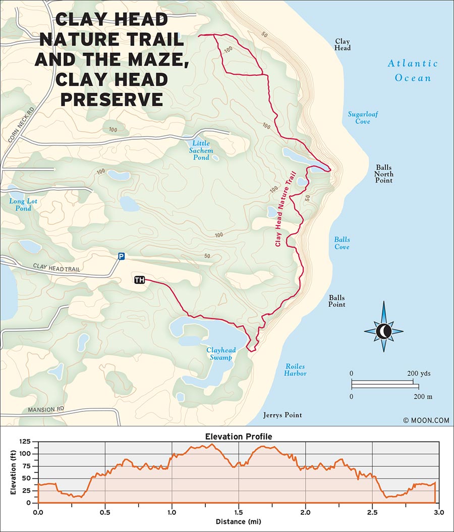
The trail sets out from the left (north) side of the parking lot at the end of Clay Head Trail Road. Follow the narrow dirt track straight (east) past the trailhead sign and through a tangle of thick bramble. The vegetation parts to expose great views of the pond and the ocean sprawling below in 0.1 mile. Descend a hill, hike across a boardwalk, and at 0.5 mile reach a side path opening to a gorgeous sandy beach on the right (east) side.
 MILE 0.5-1.0: Beach to Pond
Turn left (northeast) to stay on the sandy trail as it winds uphill. From here, the trail is marked with waist-high posts with blue arrows. You will pass several side paths to the left that lead into “The Maze,” an unmarked network of intertwining trails lined with thick vegetation. Follow the blue arrows straight north to stay on the main Clay Head Trail, which emerges on a bluff at 0.7 mile to reveal ocean vistas from the top of the 800-foot clay cliffs. As the trail winds along, it passes lovely stone walls and meadows. Arrive at a secluded pond at 1.0 mile, which offers great chances to glimpse rare wildlife such as the yellow-crowned night heron.
 MILE 1.0-2.9: Pond to The Maze
Continue straight north from the pond and reach a fork at 1.2 miles. Bear left (northwest) to follow the red arrows for a brief tour of The Maze. This counterclockwise loop (keep turning left) will return you to the fork in about 0.6 mile. From here, backtrack straight south on the blue-arrow trail to return to the parking lot.
Take the ferry to New Shoreham, Block Island. Take Water Street north around the bend where it becomes Dodge Street. At the four-way intersection, turn right on Corn Neck Road and continue for 2.6 miles. Turn right onto Clayhead Trail Road and follow it until the end. The road ends in a large dirt parking lot with a Clay Head Nature Trail sign.
GPS COORDINATES: 41°12'30.7"N 71°33'43.8"W
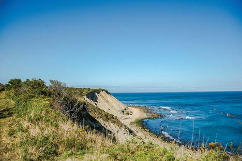
VIEWS FROM THE CLAY HEAD BLUFF
| NEARBY CAMPGROUNDS | ||||
|---|---|---|---|---|
| NAME | LOCATION | FACILITIES | SEASON | FEE |
| George Washington State Campground | 2185 Putnam Pike, Chepachet, RI 02814 | 74 RV and tent sites, 2 shelters; restrooms | mid-April–October | $20-35 |
| 401/568-2085, www.riparks.com/Locations/LocationGeorgeWashington.html | ||||
| Fishermen’s Memorial State Campground | 1011 Point Judith Rd., Narragansett, RI 02882 | 182 RV and tent sites; restrooms | mid-April-October | $20 |
| 401/789-8374, www.riparks.com/Locations/LocationFishermens.html | ||||
| Burlingame State Campground | 1 Burlingame State Park Rd., Charlestown, RI 02813 | 692 standard sites, 20 cabins, 1 shelter; restrooms | mid-April–mid-October | $20-35 |
| 401/322-8910, www.riparks.com/Locations/LocationBurlingameCampground.html | ||||
| Charlestown Breachway | Charlestown Beach Rd., Charlestown, RI 02813 | 75 RV sites | mid-April–October | $20 |
| 401/322-8910, www.riparks.com/Locations/LocationCharlestownBreachway.html | ||||
| East Beach Campground | E Beach Rd., Charlestown, RI 02813 | 20 sites for “camping unit” vehicles | late-September–late-May | $20 |
| Permit-only, 401/322-8910, www.riparks.com/Locations/LocationEastBeach.html | ||||
| Second Beach Family Campground | 474 Sachuest Point Rd., Middletown, RI 02842 | RV sites; hookups; restrooms with showers | late-September–late-May | $70 |
| 401/846-6273, http://parks.middletownri.com/second-beach-family-campground/ | ||||