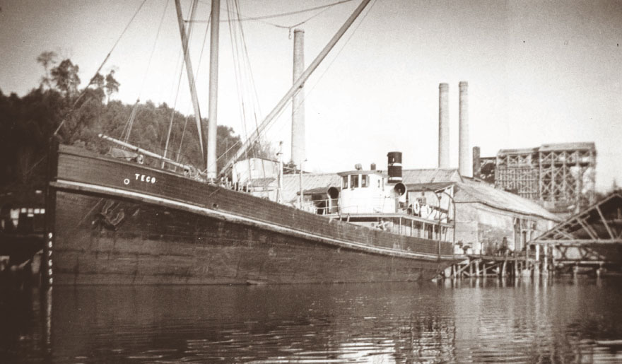
Teco at Tod Inlet, 1935. See here.
Teco at Tod Inlet, 1935. See here.
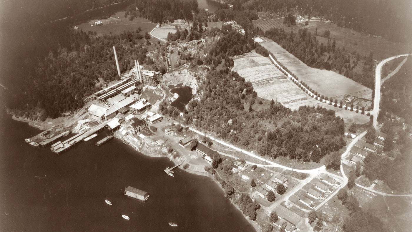
Tod Inlet, 1982. See here.
Today, when visitors cruise the sheltered waters of Tod Inlet, walk the tranquil trails of Gowlland Tod Provincial Park or view the floral landscapes at the world-famous Butchart Gardens, few understand the vast wealth of the human and natural history of this special place.
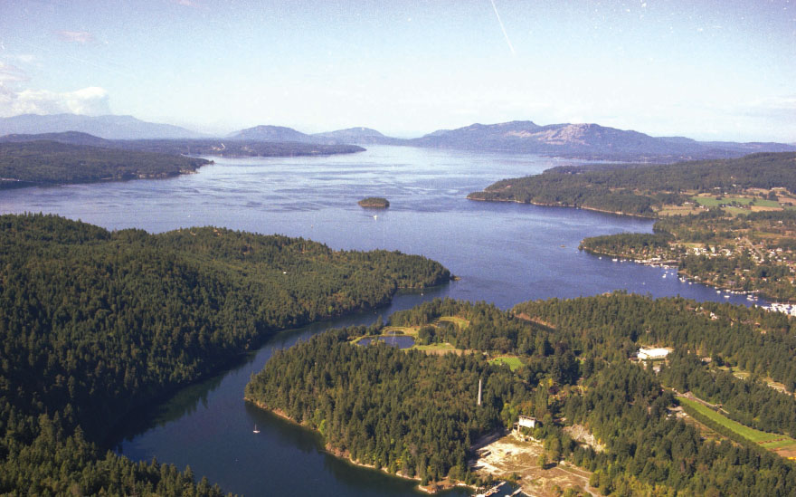
Tod Inlet is a southward extension of Brentwood Bay, a small part of the body of water known as Saanich Inlet, which separates the main part of southern Vancouver Island from the Saanich Peninsula, just north of Victoria. A long, thin passage rapidly narrows a short distance inside the entrance, then winds to the south and southeast for more than a kilometre. In one place, the passage is less than 190 metres wide, but the depth is at least 11 metres throughout. The inlet then widens as it curves to the east. Only at the end, or head, of the inlet does the depth decrease, at the tidal flats that form around the mouth of Tod Creek. The creek comes down into the inlet over several sets of small falls, audible from the water: a sort of wha cha cha, wha cha cha sound. As Tsawout Elder Earl Claxton Sr. described for me, this is the origin of the W̱SÁNEĆ (Saanich) name of Tod Creek: in SENĆOŦEN, the name is “W̱EĆEĆE.”
The inlet’s western and southern shores are steep and wooded; the northern shores are terraced and more open. Most of the shoreline is rocky, but there are a few small beaches. Looking across the inlet from the former village and cement plant site, the forests rise up the slopes to the height of land called the Partridge Hills. From the viewpoint at the Butchart Gardens’ famous Sunken Garden, the Partridge Hills are the only part of Tod Inlet that a visitor can see. The hills are also the only part of the Tod Inlet area that has not been reshaped by the forces of history.
To the Tsartlip First Nation, now based just north of Tod Inlet at Brentwood Bay, the area around Tod Inlet is known as SṈIDȻEȽ (pronounced like “sneek-with”), or Place of the Blue Grouse. The area is of significant spiritual and practical importance to the Tsartlip people. Several archaeological sites around the inlet, marked by layers of clamshells at the shoreline, attest to thousands of years of traditional occupation and use. Tod Inlet has continued to be used, but not lived in, by the Tsartlip people for the last 200 years.
The entire area was once known by the official geographical name of Tod Creek, given in 1858 to honour John Tod, an employee of the Hudson’s Bay Company and a member of the 1851 council of government for the Vancouver Island colony.
Within the last 110 years, Tod Inlet has also existed as an industrial town, a town that has seen great changes. Houses built by the cement company for the white families at Tod Inlet were occupied into the late 1950s, then abandoned, and finally destroyed. All that remains today of the community and cement factory’s structures are one small storehouse, one tall chimney and a few crumbling foundations and scattered artifacts.
From the early 1970s, area citizens urged governments to establish a park at Tod Inlet—a more suitable land use, they said, than the hotel-resort complex or housing developments proposed by the new landowners after the cement company was sold. The new development proposals were the stimulus for a long campaign to make Tod Inlet a protected place. In 1995, after 25 years of efforts by environmental groups and the Tsartlip First Nation, this area, where Indigenous people had lived for thousands of years and where immigrant workers had toiled, was finally preserved in the new Gowlland Tod Provincial Park.
Tod Inlet itself is still suffering from the ravages of industrial activities associated with the cement plant, industrial and agricultural pollution from a dump near the headwaters of Tod Creek, and logging and log-booming operations from the 1950s. Efforts to ecologically restore the inlet, led by the SeaChange Marine Conservation Society, are ongoing.
The world-famous Butchart Gardens have been designated a National Historic Site, and Tod Inlet is now officially recognized as a Historic Place of Canada. These designations recognize Tod Inlet’s connections to the local community, the province of British Columbia, Canada, North America, and the world.
Today, Tod Inlet and Gowlland Tod Provincial Park receive many visitors, who come by boat, by car, on horseback or on foot, many on a daily basis. They love the trails, the forest, the inlet and the history. To some, this is a sacred and healing place. This book is meant to help those visitors, and others who can only visit vicariously, know the history of this rich and fascinating place.
The Gray family at the Vancouver Portland Cement Company plant ruins in 1987. David R. Gray photograph.
The Gray family on the shoreline of Tod Inlet, north of the wharf, with metal debris from cement plant ruins, 1987. David R. Gray photograph.
Aerial view of Tod Inlet, 1930. See here.