18 Lime Kiln Trail

OCOTILLOS ON SOUTHERN LIME KILN TRAIL
SCENERY: 
TRAIL CONDITION: 
CHILDREN: 
DIFFICULTY: 
SOLITUDE: 
GPS TRAILHEAD COORDINATES: Dead Horse Ranch State Park terminus, at park boundary: N34° 45.815′ W111° 59.702' Red Rock State Park terminus: N34° 81.942′ W111° 83.650'
DISTANCE & CONFIGURATION: 15-mile car shuttle
HIKING TIME: 8 hours
HIGHLIGHTS: Historical route and transition from high desert to low forest
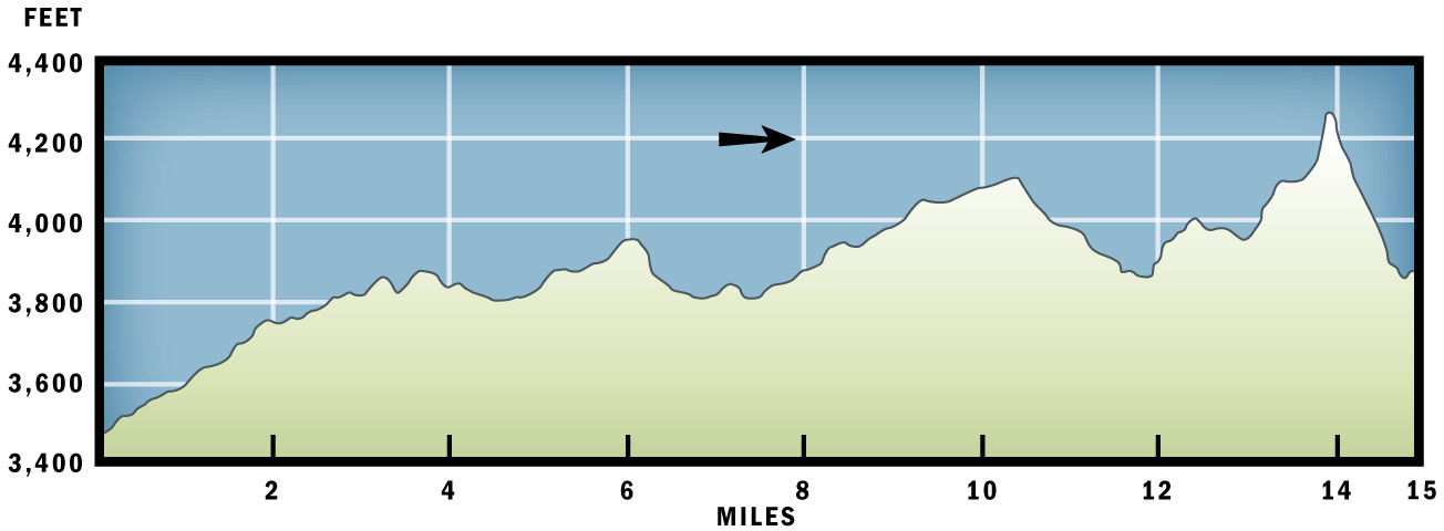
ELEVATION: 3,471 feet at trailhead to 4,278 feet at highest point
ACCESS: Dead Horse Ranch State Park has a day-use entrance fee of $7 per vehicle; parking near Red Rock State Park or at Deer Pass Trailhead requires a Red Rock Pass. See “Directions” for more details and options.
MAPS: See the route at azstateparks.com/Parks/DEHO/downloads/DEHO_Lime_Kiln_Trail_c.pdf.
FACILITIES: Restrooms and water at both state parks and Deer Pass Trailhead; about two-thirds of the journey has vault toilets.
WHEELCHAIR ACCESS: For restrooms
COMMENTS: Best done as a car shuttle. A far shorter hike can be had by parking a vehicle at either Bill Grey Road near the trail crossing or at the Deer Pass Trailhead. These waypoints divide the hike roughly in thirds about 5 miles per segment.
CONTACTS: Red Rock Ranger District, P.O. Box 20429, Sedona, AZ 86341; (928) 282-4119; www.fs.fed.us/r3/coconino/recreation/red_rock/lime-kiln-tr.shtml; Dead Horse Ranch Trails Coalition, 2011-B Kestrel Rd., Cottonwood, AZ 86326; (928) 639-0312


Overview
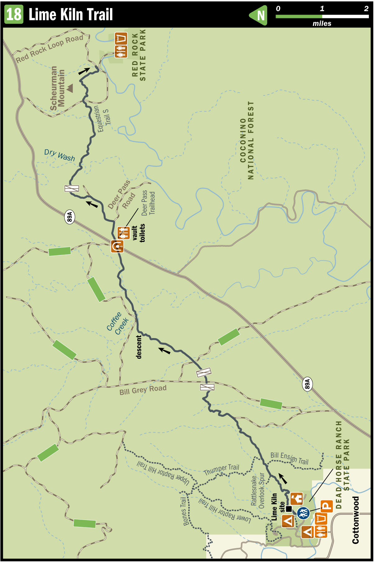
This trail traces the old wagon route that connected Cottonwood and Sedona before the construction of AZ 89A. From Dead Horse Ranch State Park, it climbs out of the high desert, crosses the prairie, tunnels beneath AZ 89A, and then climbs into the hills around Scheurman Mountain before descending to the road near the entrance to Red Rock State Park.
Route Details
This description takes you southwest to northeast, yet there are compelling reasons to go the other way. For one, northeast to southwest goes generally downhill. Another consideration is that while Dead Horse Ranch, as a campground, is open all the time, it would be logistically challenging to stage a car shuttle and make the 15-mile hike in time to enjoy Red Rock before it closes at 5 p.m. In the end, though, northeast to southwest puts a hiker in the low desert, where shade is nearly nonexistent, at the height of the afternoon sun. That realization proved decisive. In cooler weather, it may not be as compelling, and you can simply follow the hike in reverse of this description.
A number of spur trails within Dead Horse Ranch State Park lead to or become the Lime Kiln Trail 82. Head for the most straightforward access—near the bridge and the intersection of the Main Park Road and the North Campground Road. The trail that crosses the North Campground Road is the one you want. It soon bends northeast, past the campground boneyard, and climbs into and out of the wash to arrive at the site of the old lime kiln, just below the trail and dug into the side of the wash. There isn’t much left here, but you can definitely see where they did the work. The kiln site is the start of the mileage.
The path intersects other park trails as it traverses the high desert north of Cottonwood, which spreads out behind you. You pass junctions with, in order, Rattlesnake Overlook spur, the Bill Ensign Trail, and the Thumper Trail.
The remnant road (once the principal wagon route connecting Cottonwood and a tiny ranch settlement called Sedona) winds through creosote, shrubby paloverde trees, various agave species, and pipe-stemmed ocotillos as it crosses this dry plateau. Throughout, look for the 2-foot-tall caged cairns that regularly mark the route. Those cairns lead you steadily northeast, across the hills, with junipers replacing the paloverdes as you go.
At about 1.5 miles the trail winds in, along, and across a distant spur of FR 761 (though you won’t find a sign to that effect). After about 0.5 mile, cairns mark a singletrack that leaves the road to climb up and across some low hills.
Beyond those rocky hills, at about 3.5 miles, the trail joins a different spur of FR 761. The road bends here, creating an apparent Y: Go left (east), not right (south). Look for the cairn. Soon the road leads to a well-used bonfire site. A singletrack leads you due east from here, passing through a gate on its way to Bill Grey Road (FR 761), a wide, graded dirt highway across the prairie.
There is no official trailhead here, but the shoulder is wide enough to accommodate a car if you wanted to shorten the hike in one direction or another and leave a vehicle here. Yet another spur road crosses the trail a few hundred yards east, and then you pass through a second gate.
After crossing rangeland of tall grass, wildflowers, creosote, and occasional cat’s-claw, the trail climbs into some hills, paralleling a jeep trail. The latter trail, to tell the truth, presents better footing in many places than the sandy singletrack, and you could follow it instead and lose nothing. The singletrack joins the jeep trail anyway shortly before descending down the hill into a broad valley. Before starting that drop, you can see many of the rock formations that have made the little ranch village of Sedona world-famous in more modern times. The descent is the 5.5-mile mark.
Be sure, though, to stay on the singletrack as it splits from the road before crossing the first big wash, Coffee Creek. The trail represents a shortcut across the overgrazed pasture until the next wash. Past that, it rejoins the road and climbs up and around some small hills before leveling out to cross the prairie once again.
At 7.5 miles, a small wooden sign marks where the trail departs the road toward its very own underpass beneath AZ 89A. A gate guards the concrete tunnel half-filled with tumbleweeds. Beyond, the trail climbs briefly to Deer Pass Trailhead, and the vault toilets there will likely be a welcome sight. (There are, however, no other conveniences.)
The trail follows Deer Pass Road a bit before crossing it, going through a gate, and following a jeep trail past the sewage pastures. Reclaimed wastewater irrigates these fenced fields, as numerous signs will inform you. You’ll have to draw your own conclusions as to why it is necessary to advertise this.
This dirt road has numerous spurs, creating some Y-intersections, so it is important to find the cairn. In one particular spot, about 11 miles in, the cairns lead you to a locked gate. The fence on either side is no longer intact, so circumventing it is no trouble, but finding the cairn afterward can prove troublesome. It’s to the right (east), down the road.
Don’t go uphill: That’s the wrong way. Eventually, the road drops into Dry Wash (which normally lives up to its name). The route then follows the forest road (FR 9184) northeast out of the canyon, as pines and junipers become thicker and the soil redder.
Several equestrian trails cross the road, most designated with a letter. Look for Equestrian Trail S, which is also marked by a cairn, taking off to the right (northeast) and up the hill. If you cross a second wash, you’ve missed it.
Trail S climbs the hill and then turns left to follow the top of the ridge roughly north. From this ridgetop you can see high-income housing to your left (west) and Red Rock State Park to the right (east). After 0.25 mile, the trail descends to cross the paved Red Rock Loop Road and then, across the road, climbs again to the top of a small saddle, where the Scheurman Mountain Trail 56 meets it. Stay straight (roughly north) to start winding down the hill through basalt rubble and thickets of junipers. Just as you can see the entrance to Red Rock State Park, the trail turns left to cross a wash before climbing one last hill. The trail terminates at Red Rock Loop Road, about 100 feet north of the park entrance.
Nearby Attractions
Dead Horse Ranch State Park: With more than 400 developed acres and 100-plus campsites ranging from tent sites to rental cabins, this state park serves as the largest campground in the region. It also features fishing lagoons and access to the Verde River and numerous trails, including the south tail of Lime Kiln. Entrance to the park for day use is $7 per vehicle or $3 per pedestrian. Call (928) 639-0312 or visit pr.state.az.us/parks/VERI. There is also an equestrian concessionaire on-site, in the event that you don’t want to travel the trail on your own feet; call (928) 634-5283 or visit trailhorseadventures.com.
Red Rock State Park: This park lies on the banks of Oak Creek, where it winds through the red-walled canyon 5 miles south of Sedona. A number of short, easy trails travel through the pines, junipers, and grassy fields within this 286-acre nature preserve and environmental-education center. It’s day-use only—no camping available. Hours are 8 a.m.–5 p.m. daily. Entrance fee is $10 a vehicle or $3 for pedestrians. Call (928) 282-6907 or visit pr.state.az.us/parks/RERO.
Directions
Dead Horse Ranch State Park is on AZ 89A within Cottonwood, south of the intersection with AZ 260, near the noted historical downtown district. Day-use parking is near the fishing lagoons.
To get to Red Rock State Park, take AZ 89A 13 miles north of Cottonwood, or drive 5 miles south of Sedona to Red Rock Loop (the southern end: do not take the northern end by the high school). Proceed on Red Rock Loop another 3 miles to the park entrance. Farther east on Red Rock Loop, as it turns to graded dirt, you can find some parking spots on the side of the road, though parking here requires a Red Rock Pass.