EVERETT
1 Jennings Memorial and Nature Parks
11 Southwest County Olympic View Park
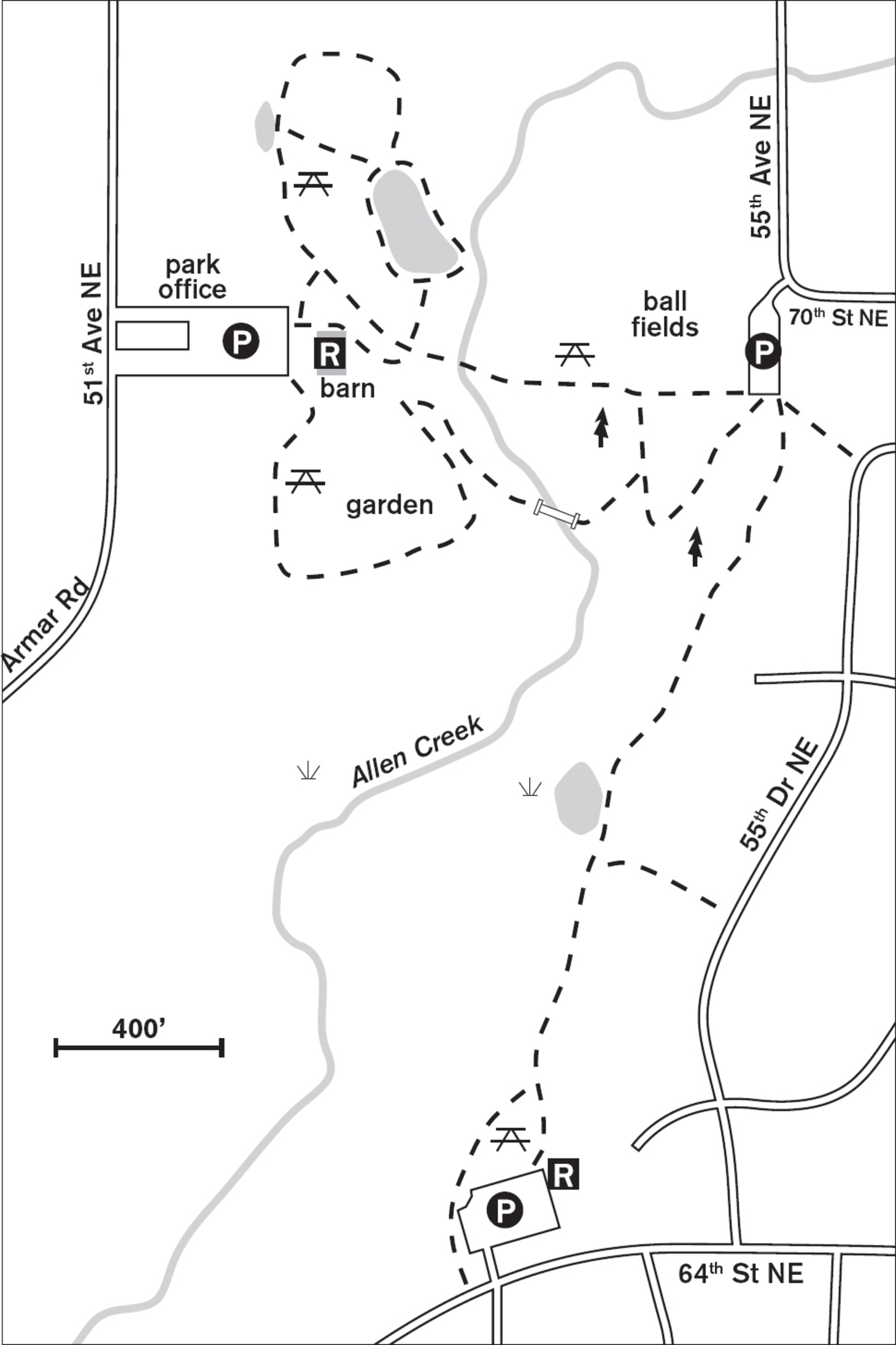
1 JENNINGS MEMORIAL AND NATURE PARKS
Marysville, 7.5 miles north of Everett
Explore 61 acres of meadow, forest, and wetland in these twin parks.
| TRAIL | 1.5 miles; paved, natural surface |
| STEEPNESS | Level to gentle |
| OTHER USES | Bicycles |
| DOGS | On leash |
| CONNECTING TRAILS | None |
| PARK AMENITIES | Picnic area, restrooms, playground, demonstration garden, interpretive signs, fishing pond, ball fields, historical displays and museum |
| DISABLED ACCESS | Restrooms, garden |


Stroll the undulating hills of these two parks from passive forest and meadows to an active park with ball fields, a children’s fishing pond, playgrounds, and a Master Gardener demonstration garden. In the wetlands, cattails make homes for marsh wrens and red-winged blackbirds. Raptors overhead reveal the presence of the tiny, secretive voles and mice that seek shelter in the grasses.
These twin parks are so closely aligned it’s hard to know when you walk from one to the other. The Armar Road entrance is for the Memorial Park, and here you’ll find the city parks office, where you can stop in for more information. History buffs will be intrigued by the 1901 steam donkey engine on display and enjoy a visit to the Marysville Historical Society museum.


A half-mile paved path leads from one park to the other and around the fishing pond. After that the trails are natural surface through the western red cedars and into the meadows and the wetland. Boardwalks and bridges allow you to navigate over the sensitive wetlands and next to softly flowing Allen Creek, which bisects the parks.
The themed demonstration garden invites you to experience an English cottage garden and a meditation garden. You can learn techniques for growing your own flowers, fruit trees, vegetables, and herbs. In summer the park rings with the sounds of children, and you’ll find classes, movies, and fishing derbies, but the wetlands and sensitive natural areas will still beckon dedicated walkers.
ADDRESS: 6915 Armar Road, Marysville
GETTING THERE: From I-5 southbound, take exit 199 (WA 528). Drive east on WA 528 for 0.7 miles. Turn left on 47th Avenue NE. Continue 0.5 miles, bearing right at the fork onto Arlington-Marysville Road/Armar Road. The park entrance is on the right.
CONTACT: Marysville Parks and Recreation Department, (360) 363-8400, www.marysvillewa.gov

2 JETTY ISLAND
1.5 miles northwest of downtown Everett
Walk and bird-watch in these 200 acres of salt marshes, beaches, and sand dunes along Port Gardner Bay.
| TRAIL | 2 to 4 miles, depending on tide; natural surface |
| STEEPNESS | Level |
| OTHER USES | Pedestrians only |
| DOGS | Not allowed |
| CONNECTING TRAILS | None |
| PARK AMENITIES | Open summer only; free ferry mid-July to Labor Day; restrooms, boating, picnic tables, classes, guided interpretive walks |
| DISABLED ACCESS | None |


Built almost a hundred years ago at the mouth of the Snohomish River to create a freshwater harbor in Puget Sound, this man-made island has succeeded in ways its creators probably never imagined. A southerly breeze cools the western shore, carrying the scent of seaweed and the barks of California sea lions. Sandpipers sprint on the mudflats; ospreys soar above. Around the Scotch broom, swallows dart and dive for their insect meals. Near the shore, crabs scurry for shelter under rocks. In the salt marsh, salt crystals glisten on the stems of the pickleweed.
Measuring 2 miles long and 0.5 miles wide, this wildlife preserve just 3 minutes from the Everett marina is the city’s summer pride. For 7 or 8 weeks each summer, Wednesday through Sunday, the eighty-passenger ferry run by the Mosquito Fleet fills to capacity to take families, walkers, and bird lovers across the Snohomish River channel to the dock on Jetty Island. From there they disperse, though the majority cluster around the picnic tables on the western shore. To find solitude, walk either north or south for 3 or 4 minutes. You’ll think you’re on a deserted island—just you and the terns, herons, swallows, and shimmering, slippery, pungent sea lettuce that lines the beach.
At low tide you can circumnavigate the island on the mudflats, though you have to be willing to get your feet squishy with mud. On the western side, a berm built by the Army Corps of Engineers has created a new salt marsh. Here you are likely to see many of the more than forty species of birds that visit or nest on the island. In early summer, expect to be dive-bombed by protective mother gulls warning you away from their nests.
ADDRESS: 10th Street Boat Launch, Everett
GETTING THERE: From downtown Everett, follow Everett Avenue west to W Marine View Drive. Turn right (north) and go 1.75 miles. Turn left (west) at 10th Street into 10th Street Boat Launch and Marine Park.
Parking fee is $3 on Friday and weekends. Ferry reservations can be made by Everett residents or groups of over eight people 48 hours in advance. Call (425) 257-8304. Other visitors can ride the ferry on a first-come, first-served basis.
CONTACT: Everett Parks and Recreation Department, (425) 257-8300, www.everettwa.org/parks


3 LANGUS RIVERFRONT PARK
6 miles east of downtown Everett
Cascade views and bird-watching abound along these 96 acres of the Snohomish River and Union Slough.
| TRAIL | 3.6-mile loop; gravel, paved |
| STEEPNESS | Level |
| OTHER USES | Bicycles |
| DOGS | On leash |
| CONNECTING TRAILS | Spencer Island (Walk #4; no bicycles or pets allowed) |
| PARK AMENITIES | Restrooms, picnic tables |
| DISABLED ACCESS | Trail, restrooms, picnic area |


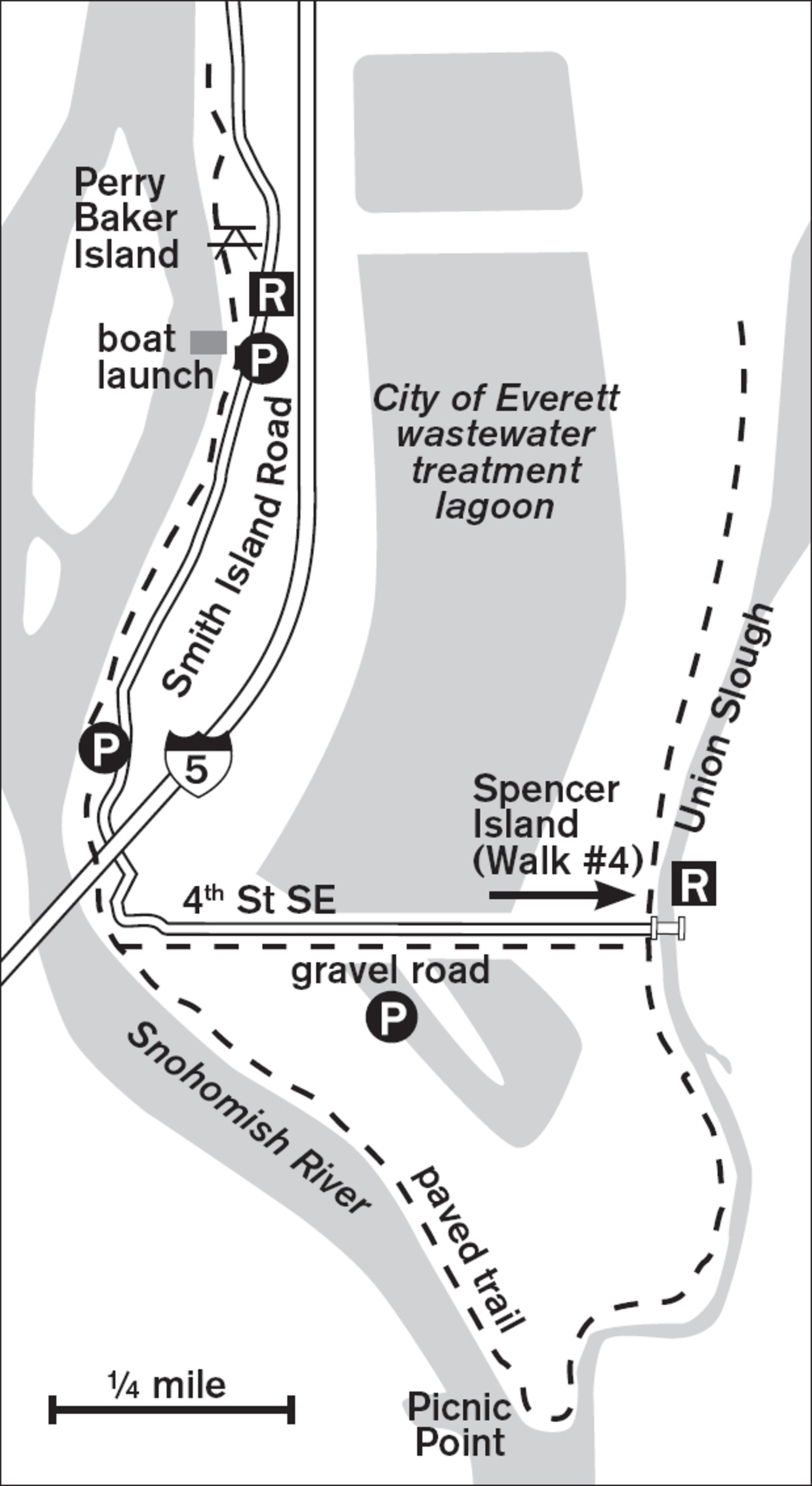
Old barges docked forever against the bank of the smooth-flowing Snohomish River recall days gone by when rivers and lakes, not roads, united the Northwest. Well-tended lawns and a paved walkway seem so genteel compared to the stalwart pilings of old docks. Great blue herons and belted kingfishers feed from the river—one on foot, the other on wing—and migrating waterfowl rest in the reeds along the shore.
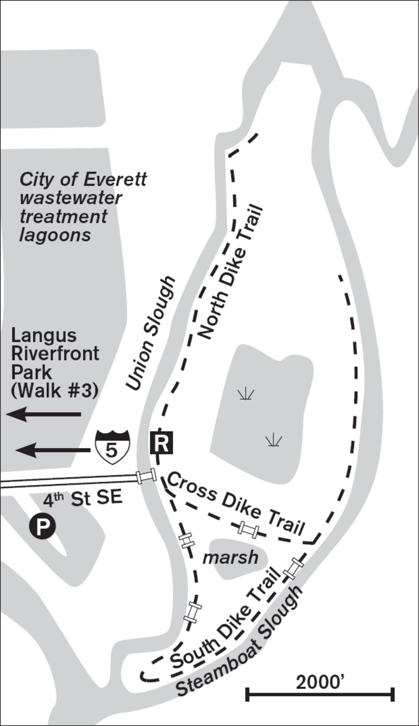
Enjoy Langus Riverfront Park with a civilized promenade along the riverfront, a hefty mile out and back, from the northern end—or with a 3-mile triangular loop walk along the Snohomish River and Union Slough. For the longer loop, continue south after the pavement ends, passing under the imposing I-5 freeway bridge. The first stretch follows the river, where fishing boats, tugs, tourist boats, and an occasional log boom float by. At the southernmost spot, Picnic Point, views open to grasslands, the Cascades, and on clear days, Mount Rainier.


From Picnic Point the trail heads north along Union Slough, where a variety of deciduous trees line the pathway on a dike above the tidal trough. Across the water (if it’s high tide) or mud (if it’s low tide) lie the marshes, ponds, and dikes of Spencer Island, a nature preserve (Walk #4). Jackknife Bridge ahead spans Union Slough, serving as an entrance to the preserve. From the bridge, you can retrace your route to stay on the paved trail, or complete the loop by walking west on the gravel maintenance road (4th Street SE) back to the river. Along the road you walk between waste treatment ponds, where waterfowl abound. With binoculars you can see a palette of colors: the distinct black-and-white plumage of the hooded merganser, the orange bill of the scoter, or the blue bill of the male ruddy duck in late spring.
ADDRESS: 400 Smith Island Road, Everett
GETTING THERE: From I-5 southbound, take exit 198 (WA 529 S/WA 99). Go south on WA 529 and turn right onto 34th Avenue NE/Frontage Road. Follow the road left under WA 99, then stay right for Smith Island Road, which leads to Langus Riverfront Park.
From I-5 northbound, take exit 195 (E Marine View Drive). Continue on E Marine View Drive. Turn right on WA 529/WA 99 N. After crossing the Snohomish River, turn right on Smith Island Road and follow it to the park.
CONTACT: Everett Parks and Recreation Department, (425) 257-8300, www.everettwa.org/parks

4 SPENCER ISLAND
6.5 miles east of downtown Everett
Union and Steamboat Sloughs surround these 415 acres of bird-watchers’ wetland paradise.
| TRAIL | 4 miles; natural surface |
| STEEPNESS | Level |
| OTHER USES | Pedestrians only; hunters from mid-October to mid-January on the north end; no pets |
| DOGS | Not allowed |
| CONNECTING TRAILS | Langus Riverfront Park (Walk #3) |
| PARK AMENITIES | Restrooms, interpretive signs, bike rack near footbridge |
| DISABLED ACCESS | None |


Spencer Island is a birder’s paradise and a frequent destination for National Audubon Society field trips. On bright days the ruddy ducks and American wigeons appear to be floating on top of their upside-down twins as they paddle across the mirrorlike surface of the pond. Northern harriers and red-tailed hawks hunt overhead. In the still waters by the marsh grasses, you might see river otters flipping and diving for fish. Nesting boxes for wood ducks and swallows dot numerous islets in the marsh, and on the southern loop bat boxes make welcome homes for these flying mammals.
But even without binoculars and a passion for birds, the miles of trail along dikes above the estuary are inviting for their hours of strolling and gazing at the scenery. After entering the preserve over Jackknife Bridge, turn either north or south on the wide wood chip–lined paths. On clear days, Mount Pilchuck dominates the skyline to the east, and to the north, Mount Baker may stand, white and craggy.


Early settlers created dikes and sloughs to remove the tidal influx of salt water and to protect their farmlands. When Washington State, Snohomish County, and the City of Everett joined forces in the early 1990s to return this area to its natural state, they breached the dike wall with culverts and bridges. Now the wetland is an estuary again, responding to the ebb and flow of the tides from Puget Sound. This combination of salt water and freshwater from the Snohomish River provides a habitat for hundreds of species of birds and mammals.
From mid-October to mid-January the northern trails (administered by the state Department of Fish and Wildlife and signposted) are open to hunting, so most walkers go south during those months. Interpretive signs provide information on the area’s history and its natural history. Benches and viewing platforms add a human touch to this otherwise wild and beautiful estuary.
ADDRESS: 4th Street SE, Everett (east end)
GETTING THERE: From I-5 southbound, take exit 198 (WA 529 S/WA 99). Go south on WA 529, and turn right onto 34th Avenue NE/Frontage Road. Follow the road left under WA 99, then stay right for Smith Island Road. Turn left on 4th Street SE (gravel road). Parking is on the right in a few hundred yards. Walk east on 4th Street SE to Jackknife Bridge, which leads to Spencer Island.
From I-5 northbound, take exit 195 (E Marine View Drive). Continue on E Marine View Drive. Turn right on WA 529/WA 99 N. After crossing the Snohomish River, turn right on Smith Island Road and proceed as above.
CONTACT: Snohomish County Parks and Recreation Department, (425) 388-6600, www.snohomishcountywa.gov/parks

5 CENTENNIAL TRAIL
8 miles southeast of Everett (Snohomish Trailhead) or 8 miles east of Everett (Machias Trailhead)
Walk portions of this 30-mile trail along the Pilchuck River for Cascade views in pastoral Snohomish Valley.
| TRAIL | 30 miles one way; paved rails-to-trails conversion |
| STEEPNESS | Level |
| OTHER USES | Bicycles; horses on separate equestrian trail |
| DOGS | On leash |
| CONNECTING TRAILS | None |
| PARK AMENITIES | Restrooms, picnic tables |
| DISABLED ACCESS | Trail access, restrooms at Pilchuck and Machias Trailheads |


Just minutes east of the I-5 corridor lies the fertile Snohomish Valley with its pastures, dairy farms, and picturesque barns. You’ve probably driven through it countless times en route to the Cascades or Eastern Washington. Now, the Centennial Trail lets you slow the pace and walk this valley, breathing the clear, fresh air (and, yes, sometimes the aroma of cows). Views are expansive, from the dairy-farm pastures to the peaks of the Cascades.
Like other paved converted railroad grades, this trail is great for distance walking, stroller pushing, or bicycling. There are twelve trailheads, so you can choose to walk either north or south.
From historic downtown Snohomish, the trail parallels Maple Avenue and the Pilchuck River. Soon, vistas open to embrace the pastures and farms. In the 1880s settlers cleared trees and drained the swampy land to leave rich, fertile soil. Now, as then, it is prime dairy land. Cows and horses graze in the lush fields.


In the small town of Machias, a replica of the old railroad station now serves as a rest area and rental facility. Near the trail’s midpoint, on the outskirts of Lake Stevens, you’ll cross several country roads and driveways, so be sure to keep kids in close check. The trail continues to ever more rural areas as it approaches Arlington.
ADDRESS: Snohomish Trailhead: 402 2nd Street, Snohomish; Pilchuck Trailhead: 5801 S Machias Road, Snohomish; Machias Trailhead: 1624 Virginia Street, Machias; Lake Stevens/20th Street NE Trailhead: 13205 20th Street NE, Lake Stevens. For details about eight other trailheads to the north, visit www.centennialtrail.com.
GETTING THERE: Snohomish Trailhead: From I-5 take exit 194 onto US 2. Head east on US 2 for about 8 miles. In Snohomish, exit US 2 at 88th Street SE. At the first light turn right onto Pine Avenue and follow Pine to the intersection with Maple Avenue for limited parking.
Pilchuck Trailhead: Proceed as above, continuing on Maple Avenue through Snohomish. Maple becomes S Machias Road. The trailhead is in about 2 miles on the right.
Machias Trailhead: Proceed as above, to the stop sign past the Pilchuck Trailhead. Turn right and follow S Machias Road to the old fire station. Turn left onto Division Street and go 2 blocks to the trailhead on the right.
Lake Stevens/20th Street NE Trailhead: From I-5 take exit 194 onto US 2. Head east on US 2 and exit left onto WA 204. Go north 2.7 miles, following signs to Lake Stevens. Turn left onto WA 9. Go 1.7 miles, then turn right onto WA 92 (Granite Falls Highway). After 2.8 miles turn right onto N Machias Road. The trailhead is in 1 mile on the right with parking for a hundred cars.
CONTACT: Snohomish County Parks and Recreation Department, (425) 388-6600, www.snohomishcountywa.gov/parks


6 NARBECK WETLAND SANCTUARY
7 miles southwest of downtown Everett
Walk a wetland trail and see wildlife flourish in this 50-acre man-made sanctuary.
| TRAIL | 1.3 miles; natural surface, boardwalk, paved |
| STEEPNESS | Level |
| OTHER USES | Pedestrians only |
| DOGS | On leash |
| CONNECTING TRAILS | None |
| PARK AMENITIES | Restroom, picnic tables, interpretive trail |
| DISABLED ACCESS | Restrooms, paved trail; some sections of gravel trail |


Spring and summer are the prime times to visit a Northwest wetland, when the new green shoots are coming up, goslings and ducklings abound, and the blackbirds return to sing in the cattails. But year-round, a small wetland such as Narbeck offers level walking, a glimpse of life in a beaver pond, and the poetic shape of deciduous branches against a blue sky.


Narbeck is the story of success in wetland mitigation banking, a process whereby a new wetland is created in advance of destroying another. When Boeing needed to expand its facilities, it worked with federal and state governments to create a large man-made wetland that serves to control flooding and provide habitat for wildlife, and is specifically created to offset any future wetland destruction in the area.
Over a 7-year timeline, the land was transformed. Earth berms were constructed to retain water in the ponds created by Narbeck Creek, and hundreds of native plants were restored to the area. Today, Narbeck is a sanctuary for many animals, including ring-necked ducks, mallards, rabbits, raptors, crows, and songbirds. An interpretive trail invites strolling and reading, or you can sit in the cave-like wildlife blind and watch for beaver and bird action on the pond.
ADDRESS: 7007 Seaway Boulevard, Everett
GETTING THERE: I-5 northbound, take exit 189 (WA 527). Immediately follow signs to WA 526/Mukilteo. Go west on WA 526 for 2.9 miles, then turn right on Seaway Boulevard. Stay in the middle lane to avoid being swept into Boeing. After the light at 75th Street SW, go 0.25 miles to the park entrance on the right.
CONTACT: Snohomish County Parks and Recreation Department, (425) 388-6600, www.snohomishcountywa.gov/parks. To volunteer, contact Friends of Narbeck Wetland Sanctuary at 425-388-5108 or visit www.narbeck.org.


7 HOWARTH PARK
2 miles southwest of downtown Everett
This 28-acre tri-level park offers views, play areas, and a forested ravine leading to beaches and an off-leash area on Possession Sound.
| TRAIL | 1 mile round trip; boardwalk, natural surface |
| STEEPNESS | Level to steep |
| OTHER USES | Pedestrians only |
| DOGS | On leash on trails; designated off-leash area on beach |
| CONNECTING TRAILS | None |
| PARK AMENITIES | Restrooms, bridge over railroad tracks, picnic and barbecue area, playground, tennis courts |
| DISABLED ACCESS | Restrooms |


Beachcomb, swim, or cavort with your dog—free of its leash!—while harbor seals frolic in the waters of Possession Sound and drift logs entice children to clamber. Howarth Park offers one of the few beach-access trails in the city of Everett. Nestled almost secretly behind suburban lawns and homes, this community park welcomes forest walkers, beach explorers, or just casual strollers.
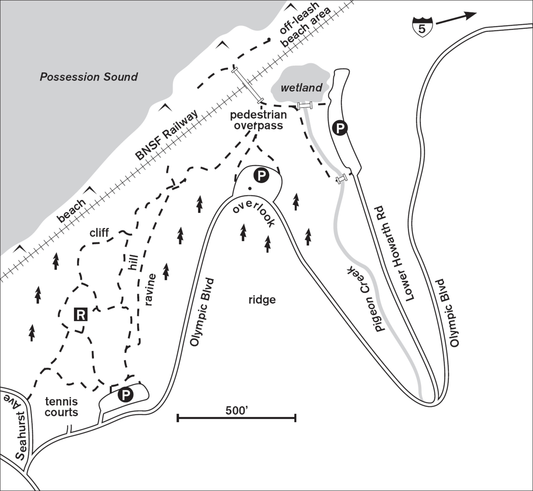
Near the tennis courts at the western end of the park you’ll find restrooms, picnic areas, and a playground. Dropping steeply from the lawn to the ravine below, a staircase trail ends at a boardwalk, which meanders above a stream. Following this trail does not lead to the beach, however, but to a T-junction with a narrow, steep trail bordering the railroad tracks. In dry weather, you can ascend the natural-surface path back to the playground and parking or return along the ravine walk. Unauthorized trails lead onto the railroad tracks, but crossing is illegal and, given the frequent passage of trains, extremely dangerous.
To reach the beach safely, either walk or drive to the eastern end of the park. From the eastern parking area you’ll find a trail that follows Pigeon Creek in a young scrub forest, and another that traverses a small wetland, then climbs to a pedestrian overpass above the railroad tracks. This is a favorite place to stand when the train whistle shrills and the locomotive and cars rumble beneath you. At the beach end is a lookout tower with panoramic views of Port Gardner Bay and the navy ships. Just north of the tower is the off-leash area, where dogs are free to romp in the sand and salt water or play tag with their human companions among the drift logs and boulders. A short walk south takes you to the public beach.
ADDRESS: 1127 Olympic Boulevard, Everett
GETTING THERE: From I-5, take exit 192 (41st Street/Broadway/Naval Station). Turn right (if southbound) or left (if northbound) on 41st Street and continue through two traffic lights. The road turns up a hillside and becomes Mukilteo Boulevard. Go west on Mukilteo Boulevard past the traffic light at Dogwood Drive and around the first curve of the road after the intersection. Just after the intersection with Seahurst Avenue, enter the park by turning right on Olympic Boulevard.
CONTACT: Everett Parks and Recreation Department, (425) 257-8300, www.everettwa.org/parks

8 FOREST PARK
1 mile south of downtown Everett
Leave the playgrounds and petting farm behind, and explore the quiet forest in this 190-acre city park.
| TRAIL | 1.5 miles; natural surface, paved utility road |
| STEEPNESS | Moderate to steep |
| OTHER USES | Pedestrians only |
| DOGS | On leash |
| CONNECTING TRAILS | None |
| PARK AMENITIES | Restrooms, animal farm, picnic shelters, playground, pool, sports fields, water playground |
| DISABLED ACCESS | Restrooms, animal farm, picnic shelters, pool |


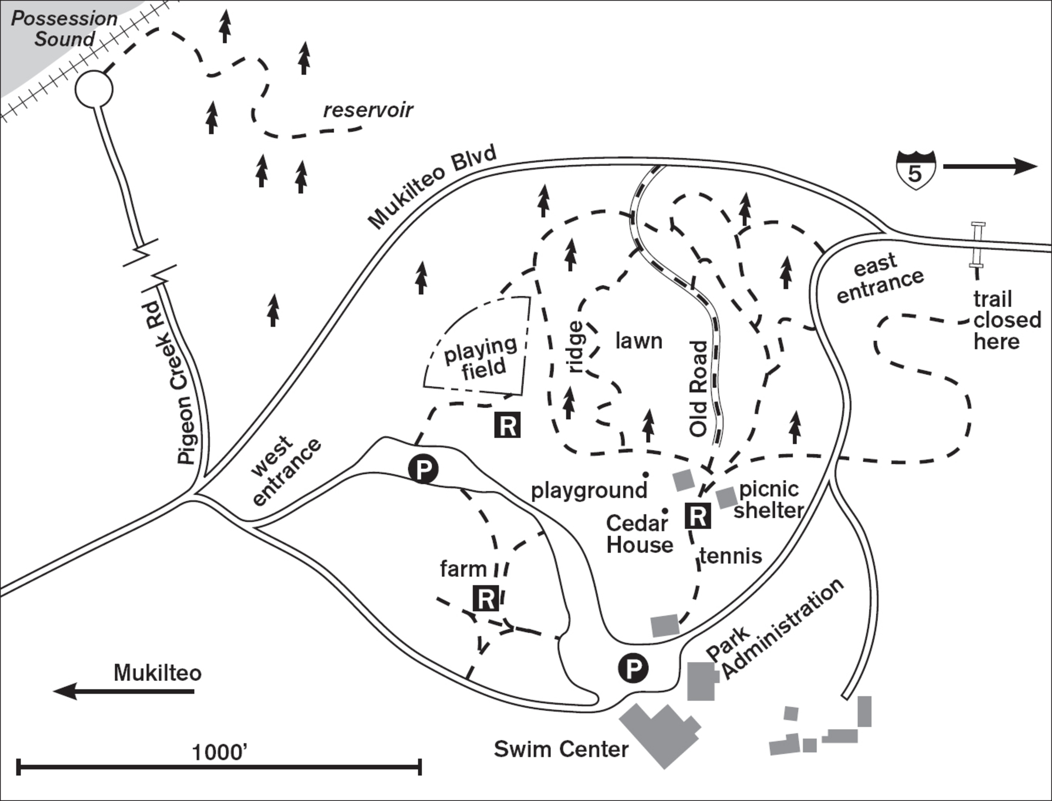
When you’ve hauled the kids off the massive playground (which is fully fenced to keep them from wandering into the steep forest), look for the wooden gate and trailhead between Cedar Hall and the picnic shelter. Here, in the largest of Everett’s city parks, forest tranquility beckons. Wide, wood-chipped paths lined with logs welcome you into the big-leaf maple and cedar forest on the ridge above a deep ravine. Look for old snags decorated with fungus and old-growth stumps with springboard notches still visible, like eyes peering out from the sometimes-charred wood. You can stroll the ridge awhile, then rest on a bench overlooking the fern-filled ravine and out to the sunny baseball diamond beyond. Though the forest looks wild, an occasional rhododendron bush and a proliferation of English ivy tell of a more cultivated past when the park housed a full-fledged zoo.
For a gentle stroll, follow the contoured trails that wind through open forest to the old utility road to the west. If you want heart-pumping exercise, head east on the staircase trails that lead down to the east entrance road and back up again. Next to a lawn, the road, lined with rock walls—and, in summer, the bright colors of foxglove in bloom—makes its way toward Mukilteo Boulevard. You can climb back to the main park grounds through the forest or on the ridges on either side of the ravine. If you choose the ridge west of the utility road, you’ll find the fern- and cedar-filled forest. Just below the playground fence are open cedar groves, perfect for warm-weather picnics. Be sure to pack out all that you pack in, as there are no trash receptacles on the trails.
Another forest walk begins at the end of Pigeon Creek Road (just across Mukilteo Boulevard from the west entrance). Drive about 0.5 miles north to the parking lot by the railroad tracks. There is no beach access, and crossing the tracks is prohibited. The wooded trail that begins here climbs the hill toward a reservoir in about 0.5 miles. Eagles nest high in the branches of the 80-year-old fir trees.
For those with kids, don’t miss the animal farm and a chance to pet, and maybe feed, the resident rabbits, ducks, pigs, goats, ponies, and llamas. The farm is open late spring through September.
ADDRESS: 802 Mukilteo Boulevard, Everett
GETTING THERE: From I-5, take exit 192 (Broadway/41st Street). Follow signs for 41st Street W. After crossing WA 99 (Evergreen Way), follow 41st Street uphill as it becomes Mukilteo E Boulevard. The park is on the left in about 1 mile.
CONTACT: Everett Parks and Recreation Department, (425) 257-8300, www.everettwa.org/parks

9 LOWELL RIVERFRONT TRAIL
2.5 miles southeast of downtown Everett
Walk a 3-mile loop along the Snohomish River, where wetlands and meadows give views of birds and the Cascades.
| TRAIL | 3-mile loop; paved |
| STEEPNESS | Level |
| OTHER USES | Bicycles |
| DOGS | On leash; short connecting walk to Lowell Park off-leash area |
| CONNECTING TRAILS | Lowell Park off-leash area on S 3rd Avenue, west of railway line (use overpass) |
| PARK AMENITIES | Restrooms, picnic tables, viewpoint |
| DISABLED ACCESS | Trail, restrooms |


This strip of manicured trail on the banks of the Snohomish River offers intimate river-edge walking and dramatic views of the Cascades. A late-afternoon visit reveals the Cascades set in bright relief to the east and a sheen of slate blue and mauve on the glassy Snohomish River. In contrast to the manicured park, the river is lined with old tumbledown shacks and craggy remains of piers. Pilings bound by cable still stand, resisting the unrelenting push of the water.
A bustling private industrial site for the past century, this area is now being restored to its natural state of meadow and wetland. From the parking lot, head either north or south. The walk to the south is more sylvan, with cottonwoods, alders, and blackberry thickets by the river. Across the water a barn, now softened by weathering, winds, and climbing vines, squats on its old foundation. It was here that E. D. Smith ran a sawmill and a logging camp, with a store, post office, and blacksmith shop, from the 1860s to the 1880s. For decades, the river was active with boats and log barges making their way to the Everett mills.
If you walk north from the parking lot, you’ll find a more parklike setting, with lawns, benches, and picnic tables. When the trail turns west into a sandy meadow, you can loop back to the parking lot on one of the myriad access roads or return on the pavement by the river’s edge, completing a 3-mile walk.
ADDRESS: 3084 Lowell Snohomish River Road
GETTING THERE: From I-5, take exit 192 (Broadway/41st Street). Follow signs for 41st Street W. Turn right onto S 3rd Avenue, which becomes Junction Avenue. Continue onto 2nd Avenue, then in 0.5 miles turn left onto Lenora Street. Continue onto Lowell Snohomish River Road to the parking area.
CONTACT: Everett Parks and Recreation Department, (425) 257-8300, www.everettwa.org/parks


10 MEADOWDALE BEACH PARK
Lynnwood, 14.5 miles southwest of Everett
Follow Lund’s Gulch Creek through forest to reach a Puget Sound beach in this 108-acre park.
| TRAIL | 2.5 miles round-trip; natural surface, paved (in lower meadow) |
| STEEPNESS | Moderate to steep |
| OTHER USES | Bicycles |
| DOGS | On leash |
| CONNECTING TRAILS | None |
| PARK AMENITIES | Restrooms, picnic tables |
| DISABLED ACCESS | Paved trail, restrooms, picnic area—call (206) 339-1208 to request disabled parking pass for beach and picnic area |


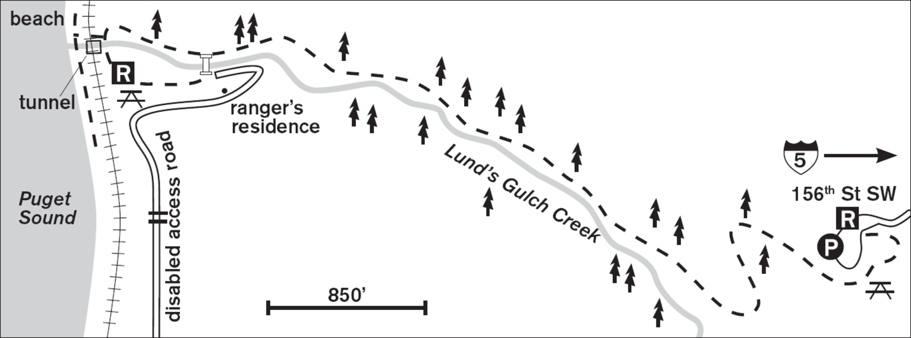
A gracefully curved descent on a wide graveled trail brings you into the aromatic forest. By keeping your eyes low on the huge bases of the Douglas fir and cedar stumps, you can envision these giants as they were a hundred years ago, before they were cut for the mills. Robins and rufous-sided towhees hop slowly from the trail.
This upland-to-beach park was created with walkers in mind. Although the beach is accessible by car for those who need to drive, the layout forces all others to take the 1.25-mile walk from the upper parking lot to the beach. Allow walking time (about 30 minutes) to return to the parking lot from the beach in daylight.
Small mileposts help you keep track of the distance traveled. At 0.5 miles a washout shows the power of water and the need to preserve soil-retaining plants on steep hillsides. Beside the trail, Lund’s Gulch Creek cuts a swath in the forest and whispers its wet sounds on its way to Puget Sound. At the footbridge, you can choose to cross to the picnic area, lawns, and lower parking lot or continue straight, still in the woods, to arrive at the tunnel to the beach. You may hear a train whistle blow, then watch a long freight chug past on the tracks that separate the forest from the sand.
To reach the water, pass beneath the tracks through the echo-filled tunnel. After the narrow ravine, the view feels exceptionally expansive. The snowy, hazy forms of the Olympics rise in the west, ferries from Mukilteo and Edmonds ply the Sound, and at low tide the beach beckons you to explore its rippled sand.
If the beach is your goal, call ahead to learn the status of the sometimes impassable tunnel to the shore.
ADDRESS: 6026 156th Street SW, Edmonds; disabled access (call ahead for gate PIN): 15433 75th Place W, Edmonds
GETTING THERE: From I-5, take exit 183 (164th Street SW). Travel west on 164th Street SW and go 1.7 miles to the intersection of 168th Street SW and WA 99. Cross WA 99 and continue west for 2 blocks. Turn right on 52nd Avenue W. Turn left on 160th Street SW, then right onto 56th Avenue W. Turn left onto 156th Street SW and continue until you reach the park entrance at the end of the road.
CONTACT: Snohomish County Parks and Recreation Department, (425) 388-6600, www.snohomishcountywa.gov/parks

11 SOUTHWEST COUNTY OLYMPIC VIEW PARK
Edmonds, 16 miles south of Everett
Inviting trails meander through 120 acres of mature forest that border Perrinville Creek as it flows to Browns Bay on Puget Sound.
| TRAIL | 1 mile total; natural surface |
| STEEPNESS | Gentle to steep |
| OTHER USES | Bicycles |
| DOGS | On leash |
| CONNECTING TRAILS | None |
| PARK AMENITIES | Interpretive trail |
| DISABLED ACCESS | None |


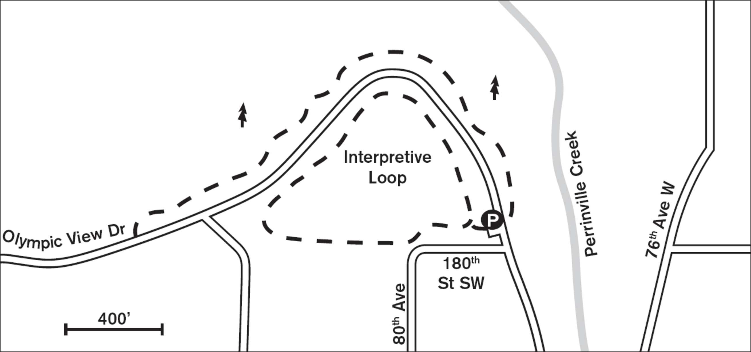
Immerse yourself in the natural sounds of bickering squirrels and cheerful birdsong just minutes from the Edmonds–Kingston ferry and the I-5 corridor. This park (known as Olympic View Park because of its location, not for views!) is the largest tract of forest within Edmonds city limits and a haven for wildlife, and with a mile of trail, it is an inviting respite from the bustle of traffic and commerce. While touted to have two nature trails, at present only the walk to the south of Olympic View Drive is fully developed as an interpretive trail. For those with little time or a desire for an easy, wide trail, the south side is where you’ll find a mini-arboretum with trees bearing Latin and local names, benches for resting weary feet, and an easy gradient for walking.
Across the road, to the north, the park is less developed but entices with steeper hills and numerous less-defined neighborhood trails. Here you can wander among remnants of old-growth forest where five-foot-wide stumps now nurture young saplings, and small trails lead to children’s forts and rope swings. For a good workout, head down the hill to the west and back up, but be careful with your footing!
Like most of the land bordering Puget Sound, this parcel was logged more than a hundred years ago, and evidence of the old-growth forest remains today in the form of springboard notches cut in the sides of huge stumps. These 120 acres were later donated to the University of Washington, and when the land was transferred to Snohomish County in 1971, it came with the condition that the parcel be forever managed as a passive woodland open space.
ADDRESS: Olympic View Drive and 180th Street SW, Edmonds
GETTING THERE: From I-5 southbound, take exit 181 (196th Street SW/WA 524) and merge onto 196th Street SW. After 2.6 miles turn right onto 76th Avenue W. Turn left at Olympic View Drive. The parking lot is on your left after you pass 180th Street SW.
From I-5 northbound, take exit 179 (220th Street SW). Turn left onto 220th Street SW. Turn right at 76th Avenue W, then left onto Olympic View Drive. The parking lot is on your left after you pass 180th Street SW.
CONTACT: Snohomish County Parks and Recreation Department, (425) 388-6600, www.snohomishcountywa.gov/parks

12 YOST PARK
Edmonds, 17 miles southwest of Everett
Explore interpretive trails along Shell Creek in these 48 acres of forested ravine and wetlands.
| TRAIL | About 1.5 miles total; natural surface, paved |
| STEEPNESS | Gentle to steep |
| OTHER USES | Pedestrians only |
| DOGS | On leash |
| CONNECTING TRAILS | None |
| PARK AMENITIES | Playground, tennis court, interpretive trail; summer only: restrooms, picnic tables, pool |
| DISABLED ACCESS | Ridge Trail, restrooms, pool area |


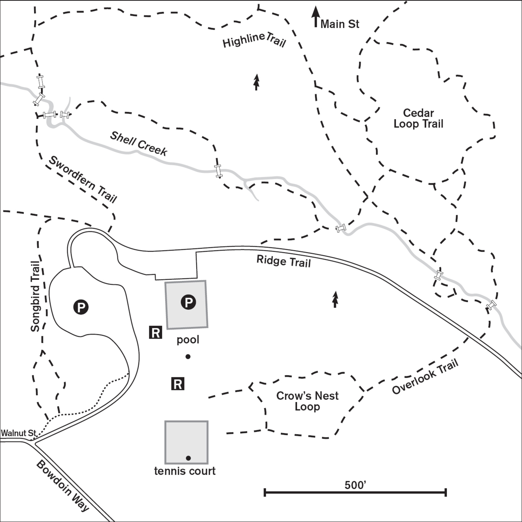
Despite its well-trodden trails, this ravine of wooded wildness in a neat residential area of Edmonds may be unknown to folks who come for the more obvious pleasures: swimming and picnicking. Deep in the greenery below the pool, Shell Creek cuts a path through a second-growth red-alder forest.
To walk in this sylvan wonderland, leave the parking lot by the yellow maintenance gate and stroll Ridge Trail (the paved maintenance road) east along the rim of the gulch. From here you can look into the upper branches of alders, maples, and firs as though you were an owl perched nearby, surveying your entire domain. There are several places where you can descend to the natural trail, letting the shouts of playing children fade above you. Listen instead for the high, tinkling warble of the winter wren or the dee-dee-dee of the black-capped chickadee.
Wooden bridges and walkways cross Shell Creek and its tributaries (some dry by late summer). The eroded banks of these streams show evidence of winter flooding. To prevent erosion, stay on the trails in this steep forest. Old stumps, long dead themselves, now provide life to cedar saplings and red huckleberry. Numbered posts correspond to notes on an informal nature guide that is available at the pool or the city parks office at 700 Main Street.
A loop trail encircles the base of the ravine. Feeder trails branch off, some rising steeply up the hillside and then petering out, others emerging on Main Street to the north. To the west, the trail crosses bogs and ends at the remains of an old concrete dam. Backtrack a short way to where the trail climbs again to rejoin the Ridge Trail near the parking area.
ADDRESS: 9535 Bowdoin Way, Edmonds
GETTING THERE: From I-5 southbound, take exit 179 (220th Street SW/Mountlake Terrace). Turn right on 220th Street SW. Go about 1.9 miles and turn right onto 92nd Avenue W. Go 0.5 miles and turn left onto Bowdoin Way. The park entrance is on the right, on the corner of Bowdoin Way and 96th Avenue W.
From I-5 northbound, take exit 177 (WA 104/Edmonds). Follow WA 104 toward Edmonds. Go about 2.8 miles and turn right on 100th Avenue W. This becomes 9th Avenue S. Go about 1 mile and turn right on Walnut Street, which becomes Bowdoin Way.
CONTACT: Edmonds Parks, Recreation, and Cultural Services Department; (425) 771-0230; www.edmondswa.gov/parks-recreation-departments/explore-parks.html

13 LYNNDALE PARK
Lynnwood, 15 miles southwest of Everett
Stroll this 40-acre enclave of quiet second-growth forest just minutes from suburbia.
| TRAIL | 1.5 miles total; natural surface, paved |
| STEEPNESS | Level to steep |
| OTHER USES | Bicycles on paved trails |
| DOGS | On leash |
| CONNECTING TRAILS | None |
| PARK AMENITIES | Restrooms, playground, picnic shelter, amphitheater, basketball courts, ball fields, tennis courts, skate park |
| DISABLED ACCESS | Paved trail, restrooms, picnic shelter |


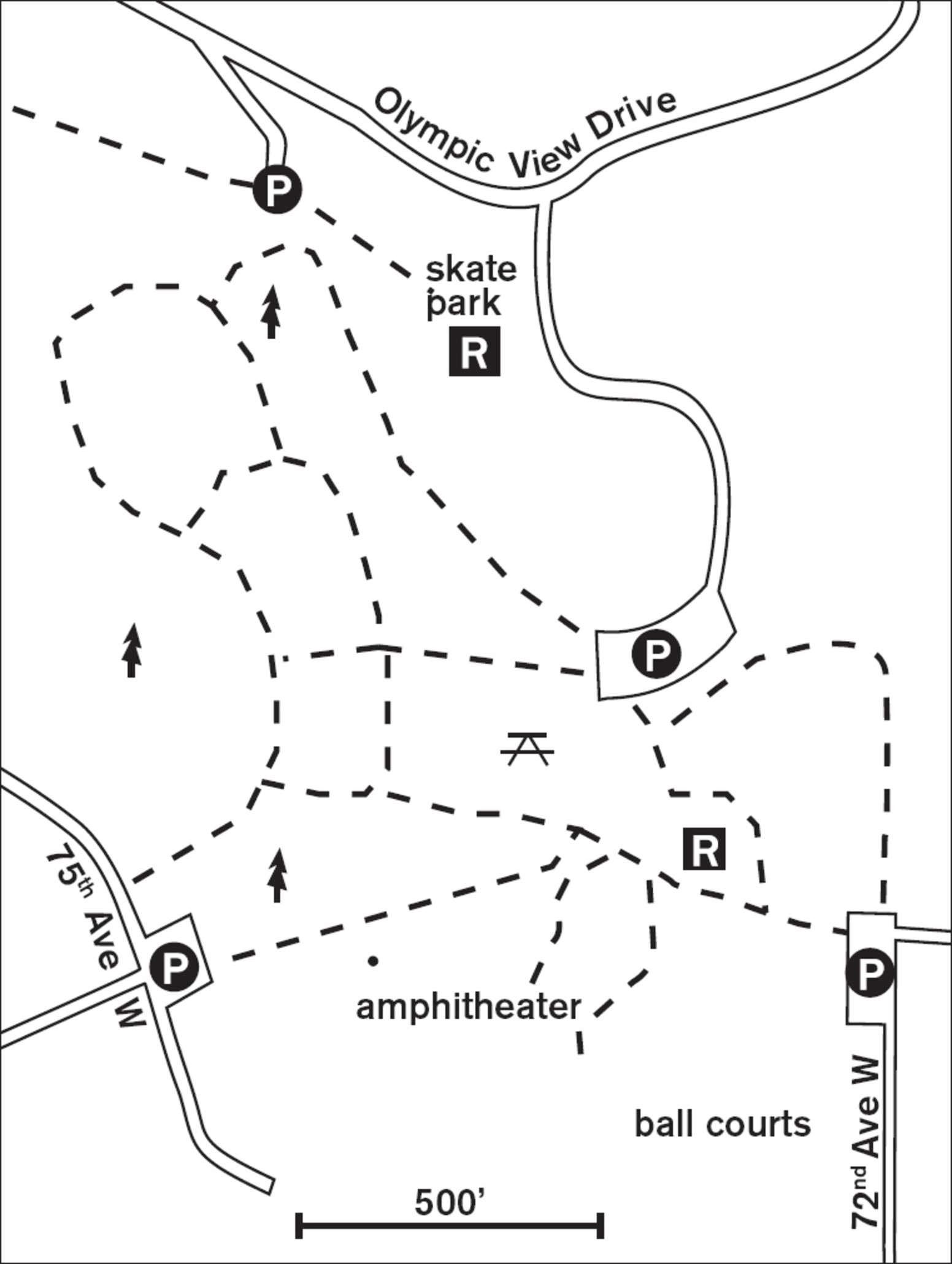
Like many other community parks, this one hides its best features behind sports courts and picnic shelters. Very accessible to wheelchairs, strollers, and little feet in skates, 0.5 miles of paved trails lead from the easternmost parking lot west past an amphitheater, and from there another mile of trail winds through the quiet second-growth forest. Here big-leaf maples form a cool canopy in summer or create graceful frames around a pale winter sky. Autumn paints the forest orange, red, yellow, and brown.
The paved trail crosses wide gravel trails and narrow natural trails, all hinting at the possibilities for exploration. Venture onto the natural trails and find the ravine (an old gravel pit, long ago reclaimed by nature) and the new wooden steps, the latter courtesy of the local Boy Scouts. The park boundaries are clear, so wander at will.


ADDRESS: 18927 72nd Avenue W, Lynnwood
GETTING THERE: From I-5 southbound, take exit 181 (WA 524). Merge onto 196th Street SW. In 2 miles turn right onto 68th Avenue W. Turn left onto 189th Place SW, then left onto 72nd Avenue W.
From I-5 northbound, take exit 179 (220th Street SW). Turn left on 220th Street SW. In about 0.5 miles turn right onto 66th Avenue W. In 0.8 miles turn left onto 208th Street SW then right onto 68th Avenue W. After 1 mile turn left onto 189th Place SW. Go 0.3 miles and turn left onto 72nd Avenue W. A northern parking lot is reached via Olympic View Drive.
CONTACT: Lynnwood Parks, Recreation, and Cultural Arts Department; (425) 670-5732; www.lynnwoodwa.gov/playlynnwood/parks.htm

14 TERRACE CREEK PARK
Mountlake Terrace, 16 miles south of Everett
A streamside trail wanders through 60 acres of playing fields and forested ravine.
| TRAIL | 3 miles round-trip, plus spurs; paved, gravel |
| STEEPNESS | Gentle to steep |
| OTHER USES | Bicycles |
| DOGS | Off-leash near the Recreation Pavilion, otherwise on leash |
| CONNECTING TRAILS | None |
| PARK AMENITIES | Restrooms, playground, picnic areas, disc-golf course, ball fields |
| DISABLED ACCESS | Paved trail, restrooms |


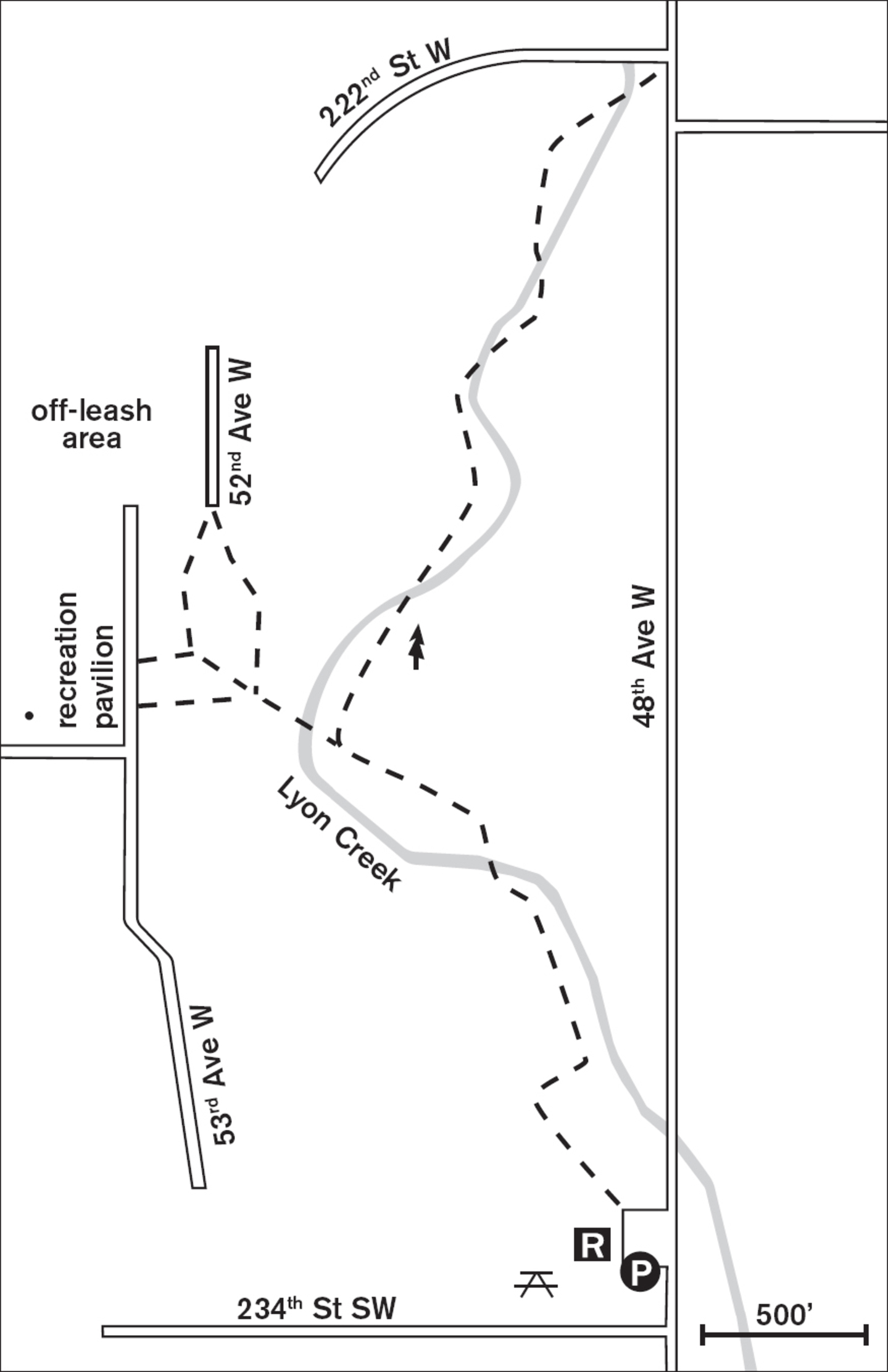
In this small neighborhood park, the trail gently ascends a peaceful strip of forest in a ravine below suburban Mountlake Terrace. Beginning as a paved walkway by the playground lawn, the trail soon changes to more rugged gravel and climbs moderately into the stately second-growth forest. Deep in the wooded ravine, the air is still and quiet. Winter wrens hop from bush to bush and woodpeckers tap old snags for their beetles and bugs. This suburban forest is home to opossums, raccoons, and other small forest critters.


Lyon Creek murmurs softly alongside the trail. Side trails lead to ridgetop homes invisible behind summer growth, but one trail, heading sharply west, will lead to the Mountlake Terrace Recreation Pavilion, and just north of that, a large off-leash dog park between 53rd Avenue W and 52nd Avenue W. The main north–south trail ends when it reaches 222nd Street SW, but there are numerous side trails to explore along the way.
The strange-looking objects that resemble open metal trash containers throughout the park are in fact holes for disc golf, a game of skill for those adept at tossing Frisbee-like discs long distances. Most of the disc-golf course is along spur trails on the sides of the steep ravine. It’s interesting to imagine the contortions necessary to retrieve stray discs from the thickets of blackberry and nettle.
ADDRESS: 23200 48th Avenue W, Mountlake Terrace; Recreation Pavilion and off-leash area: 5303 228th Street SW, Mountlake Terrace
GETTING THERE: From I-5 southbound, take exit 179 (220th Street SW/Mountlake Terrace). Turn left onto 220th Street SW. Turn right on 56th Avenue W, then left on 236th Street SW. Go about 0.8 miles and turn left on 48th Avenue W. The park is on the left at the corner of 48th Avenue W and 233rd Street SW.
From I-5 northbound, take exit 178 (236th Street SW/Mountlake Terrace). Turn right on 236th Street SW and proceed as above.
CONTACT: Mountlake Terrace Recreation and Parks Department, (425) 776-9173, www.cityofmlt.com/530/recreation-parks

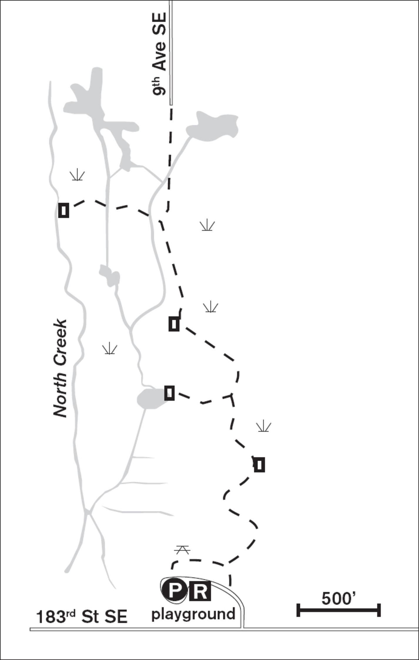
15 NORTH CREEK PARK
Mill Creek, 12 miles south of Everett
Interpretive boardwalks cross 81 acres of wetlands for bird-watching and nature study.
| TRAIL | 1.5 miles round-trip; boardwalk |
| STEEPNESS | Level |
| OTHER USES | Pedestrians only |
| DOGS | On leash |
| CONNECTING TRAILS | North Creek Trail |
| PARK AMENITIES | Restrooms, interpretive signs, picnic tables, playground, viewpoint |
| DISABLED ACCESS | Restrooms |


Step from the pavement to a sturdy boardwalk rimmed by waving cattails. Overhead, red-tailed hawks may soar, and in the hardhack Virginia rails may cackle. This enclave of open wetlands is excellent for bird-watching or studying the wetland habitat. Although surrounded by suburban homes, the reed canarygrass and beaked sedge grow tall enough to give you a sense of solitude. But you are most definitely not alone: not only is the wetland home to dozens of species of birds, including great blue herons, song sparrows, common snipes, marsh wrens, and many species of ducks, but beavers dwell here as well.
This level boardwalk trail meanders north for more than 0.5 miles over what is technically called Mukilteo muck (really!), which refers to the waterlogged soil of the wetland. Interpretive signs and benches border the trail; two spurs lead west to ponds and viewpoints near the creek.
Nestled between rolling hills, this land was once owned by the Bailey family of Mill Creek. When the county purchased the land, it recognized its value as a natural storm-water retention area. Luckily, they also saw its value as a natural classroom and park.
ADDRESS: 1011 183rd Street SE, Mill Creek
GETTING THERE: From I-5, take exit 183 (164th Street SW). Go east on 164th Street for 1.8 miles. Turn right (south) on the Bothell-Everett Highway (WA 527) and go 1.3 miles. Turn right on 183rd Street SE and go 0.2 miles. The park is on the right.
CONTACT: Snohomish County Parks and Recreation Department, (425) 388-6600, www.snohomishcountywa.gov/parks

16 BOB HEIRMAN WILDLIFE PRESERVE
12 miles southeast of Everett
Meander through 343 acres of wild wetland and meadow out to cobble beaches on oxbows of the Snohomish River.
| TRAIL | 2 to 3 miles round-trip; gravel, natural surface |
| STEEPNESS | Level |
| OTHER USES | Pedestrians only; no pets |
| DOGS | Not allowed |
| CONNECTING TRAILS | None |
| PARK AMENITIES | Restroom (portable), picnic tables, fishing access |
| DISABLED ACCESS | None |


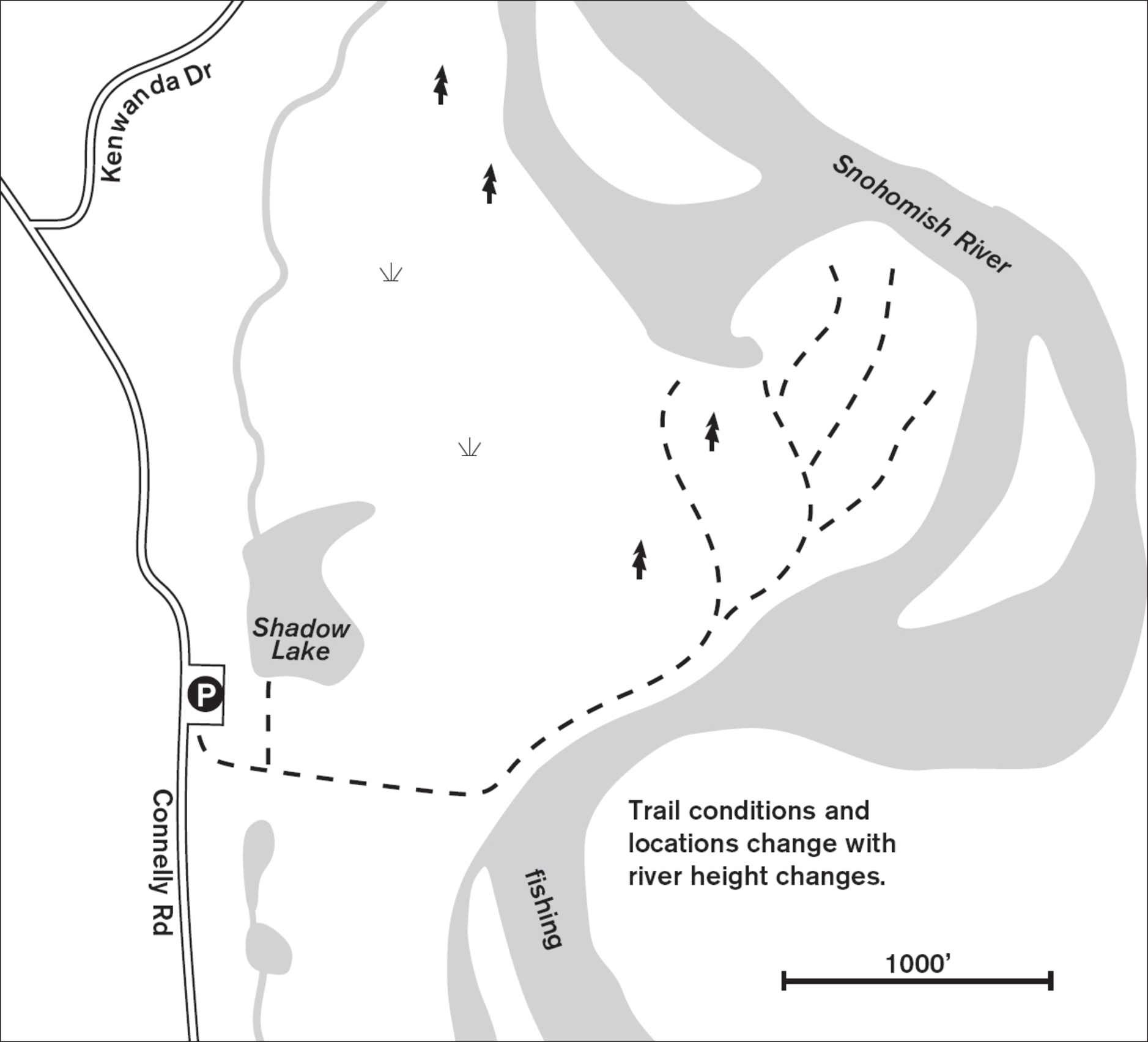
A crisp winter day is a good day to step off the manicured trails and tackle the wildness of Bob Heirman Wildlife Preserve, also known to local anglers as Thomas’ Eddy. With the deciduous trees spiking the blue sky with slender branches, the views to Mount Baker and the Cascades are unparalleled. It’s easier, too, to get good views of the hundreds of overwintering birds on Shadow Lake and Robins Pond. Mallards, grebes, and buffleheads make mottled dark spots on the gray-blue lake, but it is the trumpeter swans, white, graceful, and huge, that stand out from the flock.
These 343 acres were saved from development by fisherman and activist Bob Heirman, who worked with the county to preserve this habitat for wildlife and fishing access. Today, this wildlife preserve on Thomas’ Eddy is being left to return to nature without much interference from county maintenance crews. This means the paths stay clear because of constant use, not mowers and blowers, and when the seasonal floods sweep debris onto the riverbanks, the trails to the water will change.
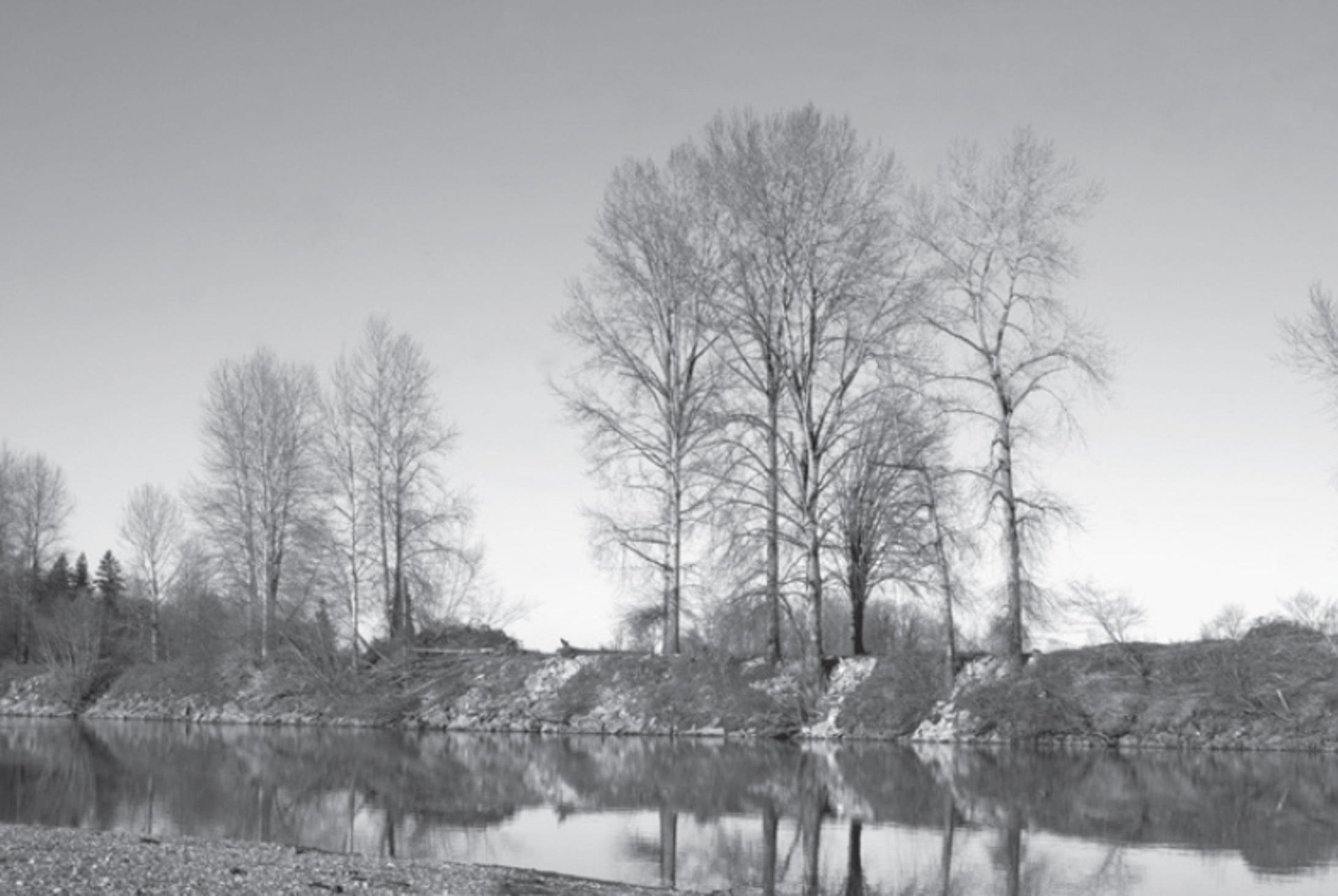

From the well-kept lawns and picnic area near the parking lot, a short gravel path leads to two viewpoints over Shadow Lake for some great birding. From there, walk east toward the river, through high grass in summer but on a clearer trail in winter. Wetlands stretch both north and south of the trail. Near the river’s edge, a natural berm creates a dry pathway to lead you either up- or downstream. There may be downed trees to negotiate and trunks to crawl over, so this is not a trail for those seeking an easy stroll. Kids will probably love it, though, as there is a game of finding the best pathway through the flood debris. The goal is to arrive on the expansive, ever-changing cobble beaches of the Snohomish River.
When the steelhead run in winter and summer, this is a great fishing area, and you’ll likely see fishing skiffs making their way up and down the river. Don’t be surprised if the parking lot is full! In the dry season, the river takes on a languid motion and meanders slowly over sand and pebbles, making a possible swimming or wading hole. In winter, though, the river moves with a ferocious current, and it’s best viewed from the safety of the cobbled banks.
ADDRESS: 14913 Connelly Road, Snohomish
GETTING THERE: From I-5 take exit 186 (WA 96 E/128th Street SW). Go east on WA 96 for 3.3 miles, then veer left onto Seattle Hill Road. After 1.5 miles, turn right onto WA 96/Lowell-Larimer Road. Continue for 2.7 miles (it becomes Broadway Avenue) and bear left onto Connelly Road. In 0.8 miles the preserve will be on your left.
CONTACT: Snohomish County Parks and Recreation Department, (425) 388-6600, www.snohomishcountywa.gov/parks

17 LORD HILL REGIONAL PARK
15 miles southeast of Everett
Snohomish River beaches, ponds, and mountain views highlight this 1,463-acre multiaged forest and wetland habitat.
| TRAIL | More than 6 miles total; gravel, natural surface |
| STEEPNESS | Gentle to moderate |
| OTHER USES | Bicycles, horses |
| DOGS | On leash |
| CONNECTING TRAILS | None |
| PARK AMENITIES | Restrooms, interpretive signs, picnic areas, playground, viewpoints |
| DISABLED ACCESS | None |


In the middle of the Snohomish River valley, a single hill rises 600 feet above the floodplain, welcoming walkers and horses to its wild and shaded forest paths. A remnant of long-ago volcanic outcroppings, Lord Hill derives its name from homesteader Mitchell Lord, who had a dairy farm on the flat land below the hill in the 1880s. By the 1930s the last old-growth timber had been cut, and in the 1980s the Department of Natural Resources cut patches of second-growth forest, producing today’s multiaged forest and wetland habitat.
From the parking lot, head down the fragrant wood-chip path deep into the fir, hemlock, and maple forest. Where the trail levels, you’ll be glad of sturdy puncheon bridges that span the miniature wetlands along the horse-trodden trail. Soon the wood chips and puncheons give way to a wide graveled path leading to a T-junction. To the left you reach one of the park’s nine ponds. Turning right takes you up a rise in dense forest from which several trails branch off.
The map at the parking lot can be confusing, and until the signage and trails are completed, keep your internal compass working and ask equestrians the way out if you’re not sure. With luck, you’ll find one of the ponds with active beavers, or evidence of the resident deer or occasional bear or bobcat. A trek to the pipeline trail or Devil’s Butte Lookout affords grand views of Mount Baker to the north and the Olympics to the west.
ADDRESS: 12921 150th Street SE, Snohomish
GETTING THERE: From I-5, take exit 194 (US 2/Wenatchee). Stay right at the end of the trestle and go about 2.5 miles. Turn right onto WA 9. At the Snohomish/Riverview Road/2nd Street exit, turn left on 2nd Street, then right onto Lincoln Avenue S (which becomes the Old Snohomish Monroe Highway). Go 2.7 miles and turn right on 127th Avenue SE. Go 2 miles to 150th Street SE. Turn left into the parking lot.
CONTACT: Snohomish County Parks and Recreation Department, (425) 388-6600, www.snohomishcountywa.gov/parks


18 PARADISE VALLEY CONSERVATION AREA
Woodinville, 20 miles southeast of Everett
In 793 acres of fern-filled forest, follow miles of well-signed trails to Cascade views and down into lush wetlands.
| TRAIL | 13 miles; natural surface |
| STEEPNESS | Gentle to moderate |
| OTHER USES | Bicycles, horses |
| DOGS | On leash |
| CONNECTING TRAILS | None |
| PARK AMENITIES | Restrooms, interpretive trail, map signs |
| DISABLED ACCESS | Restrooms |


Step back in time to a land bedecked in soft and rustling sword ferns, a land green with salal and Oregon grape undergrowth, shaded by young deciduous trees. Imagine small dinosaurs lurking about in the brush. Such is the luxuriant beauty of Paradise Valley Conservation Area. This almost 800-acre park was part of the 1887 homestead of the Lloyd family and remained in the family until its purchase by Snohomish County in 2000. Logging roads crisscrossed the land and form the basis for some of today’s trails through the almost 100-year-old secondary forest. The ridge trails remain green throughout the year under their canopy of Douglas fir and western hemlock, while the valley’s cottonwoods, willows, and dogwoods glow with color in autumn. The park’s extensive wetlands are home to beavers, frogs, and salamanders, while the forest provides habitat for coyotes, bears, and cougars. Just outside the current park boundary (but part of the next phase of development), Cottage Lake Creek abounds in resident trout and is graced by migrating salmon in spawning season.
Well-developed and maintained multiuse trails testify to the park’s appeal to a variety of users and its strong support in the hiking, mountain biking, and equestrian communities. There are miles of hiking-only trails, and with extensive signage, walkers can choose to avoid the popular (and sometimes muddy) biking trails if they wish. The gentle Whispering Firs Interpretive Trail is a great starter hike for young families.
ADDRESS: 23210 Paradise Lake Road, Woodinville
GETTING THERE: From I-5, take exit 182 merging onto I-405 S. Take exit 23A to WA 522 east. Go left at the fork merging onto WA 522 E. Turn right at Paradise Lake Road. Go 1.7 miles to the parking lot, which is just north of the Lloyd family farm on the west side of the road.
From I-405 northbound, take exit 23 (US 2) toward Woodinville/Wenatchee, then merge onto WA 522 E. Go 5 miles and turn right at Paradise Lake Road. The parking lot is 1.7 miles down the road on the right.
CONTACT: Snohomish County Parks and Recreation Department, (425) 388-6600, www.snohomishcountywa.gov/parks


