SEATTLE
19 Boeing Creek and Shoreview Parks
27 Warren G. Magnuson Park and NOAA Art Walk
31 The Grand Forest (Bainbridge Island)
32 Gazzam Lake Nature Preserve (Bainbridge Island)
33 Fort Ward Park (Bainbridge Island)
38 Luther Burbank Park (Mercer Island)
19 BOEING CREEK AND SHOREVIEW PARKS
Shoreline, 17 miles north of downtown Seattle
79 acres of neighboring parks offer urban amenities and pristine nature where a clear stream fills a hidden lake.
| TRAIL | 4 miles; natural surface, paved |
| STEEPNESS | Level to steep |
| OTHER USES | Boeing Creek: Pedestrians only; Shoreview: Bicycles |
| DOGS | Off-leash area in Shoreview Park, otherwise leash and scoop |
| CONNECTING TRAILS | None |
| PARK AMENITIES | Boeing Creek: Benches, picnic area; Shoreview: Restrooms, playground, picnic area, ball fields, lake access (no lifeguard) |
| DISABLED ACCESS | Paved trails and restrooms in Shoreview Park |


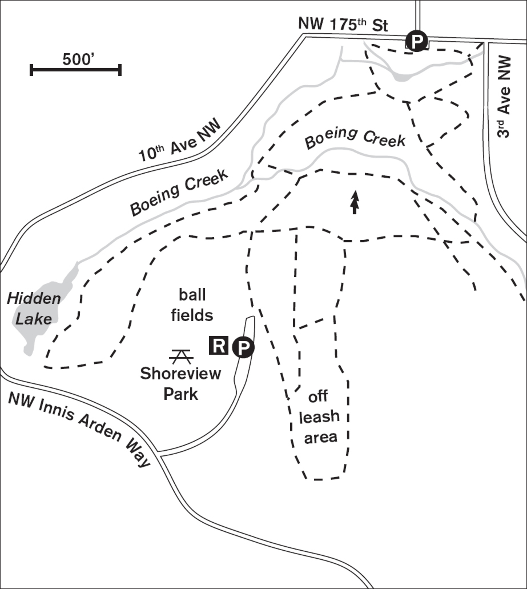
Follow serpentine trails deep into the ravine and then up onto the ridge of this green gem of a forest in the heart of Shoreline. Watch for pileated woodpeckers on the snags and cedar waxwings in the meadows in summer. Rated one of Puget Sound’s finest urban forests by the scientists at EarthCorps/Seattle Urban Nature, Boeing Creek Park has a corps of volunteers who have put in many hours rejuvenating the trails and removing invasive plants from the waterway. The park is home to mountain beavers, raccoons, and red foxes, as well as a number of unusual trees such as a 200-year-old western yew. Both eastern gray squirrels and Douglas squirrels frolic among the branches.
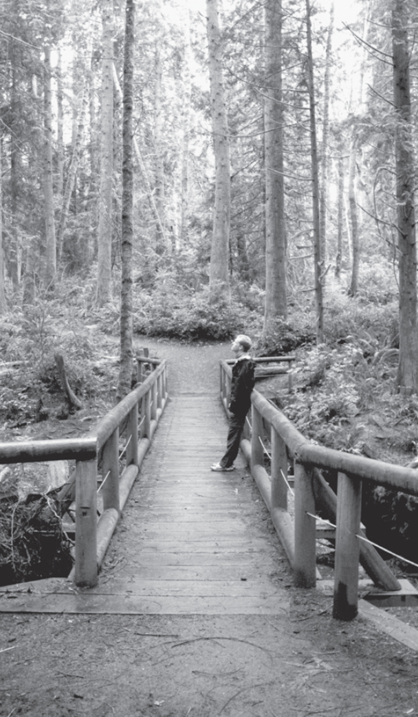
From the northern parking lot, you can walk around the detention pond or dive straight into the forest. Going southwest (right) into the forest, the trail follows the streambed, crossing over a bridge of concrete steps placed there by a Girl Scout troop and replaced each year when the stream floods. The sandy soil is especially vulnerable to erosion, so it’s important to stay on the trail and not be tempted to take shortcuts up the steep ravine sides. Coming round a corner brings you to Hidden Lake with its glass-clear water and usually a family or two of ducks. If you’re lucky, you may see them dive and skim the algae off the bottom of the lake. Wading is allowed, but there is no lifeguard.
From Hidden Lake, the trail climbs through the forest to emerge in an open space of broom and berries, madrona, and cottonwood. Although the boundary isn’t marked, you’ve now crossed into adjoining Shoreview Park, an active recreation area with tennis courts, sports fields, restrooms, playground, and ADA-accessible walkways. Above the tennis courts is a large off-leash area with a track for running your canine friend through his or her paces. Back to the north, into the forest again, the trail stays high on a traverse above the creek and then angles down to meet the streambed once again in Boeing Creek Park.
ADDRESS: Boeing Creek Park: 17229 3rd Avenue NW, Shoreline; Shoreview Park: 700 NW Innis Arden Way, Shoreline
GETTING THERE: Boeing Creek Park: From I-5, take exit 176 (NE 175th Street). Go west on 175th Street. Continue 0.8 miles and turn left on Aurora Avenue N. Go 0.8 miles and turn right onto N 160th Street. For Boeing Creek Park, turn right on Dayton Avenue N. Go 0.3 miles and make a slight left onto Carlyle Hall Road N. Continue about 0.5 miles onto 3rd Avenue NW. The park is on your left. There is street parking here. Further parking is ahead and to the left on N 175th Street.
Shoreview Park: Follow the directions above to N 160th Street. Continue on N 160th Street until it becomes Innis Arden Way. Drive about 0.5 miles to Shoreview Park on the right.
CONTACT: Shoreline Parks, Recreation, and Cultural Services Department; (206) 801-2600; www.shorelinewa.gov/government/departments/parks-recreation-cultural-services

20 HAMLIN PARK
Shoreline, 11 miles north of downtown Seattle
Walk in 80 acres of towering, open forest with wide paths and open ravines, or stroll the perimeter of sunny ball fields.
| TRAIL | 3 miles; paved, natural surface |
| STEEPNESS | Level to steep |
| OTHER USES | Bicycles |
| DOGS | On leash |
| CONNECTING TRAILS | None |
| PARK AMENITIES | Restroom, picnic tables, playground, ball fields, art, orienteering course, historic canons |
| DISABLED ACCESS | Paved trail bordering ball fields |


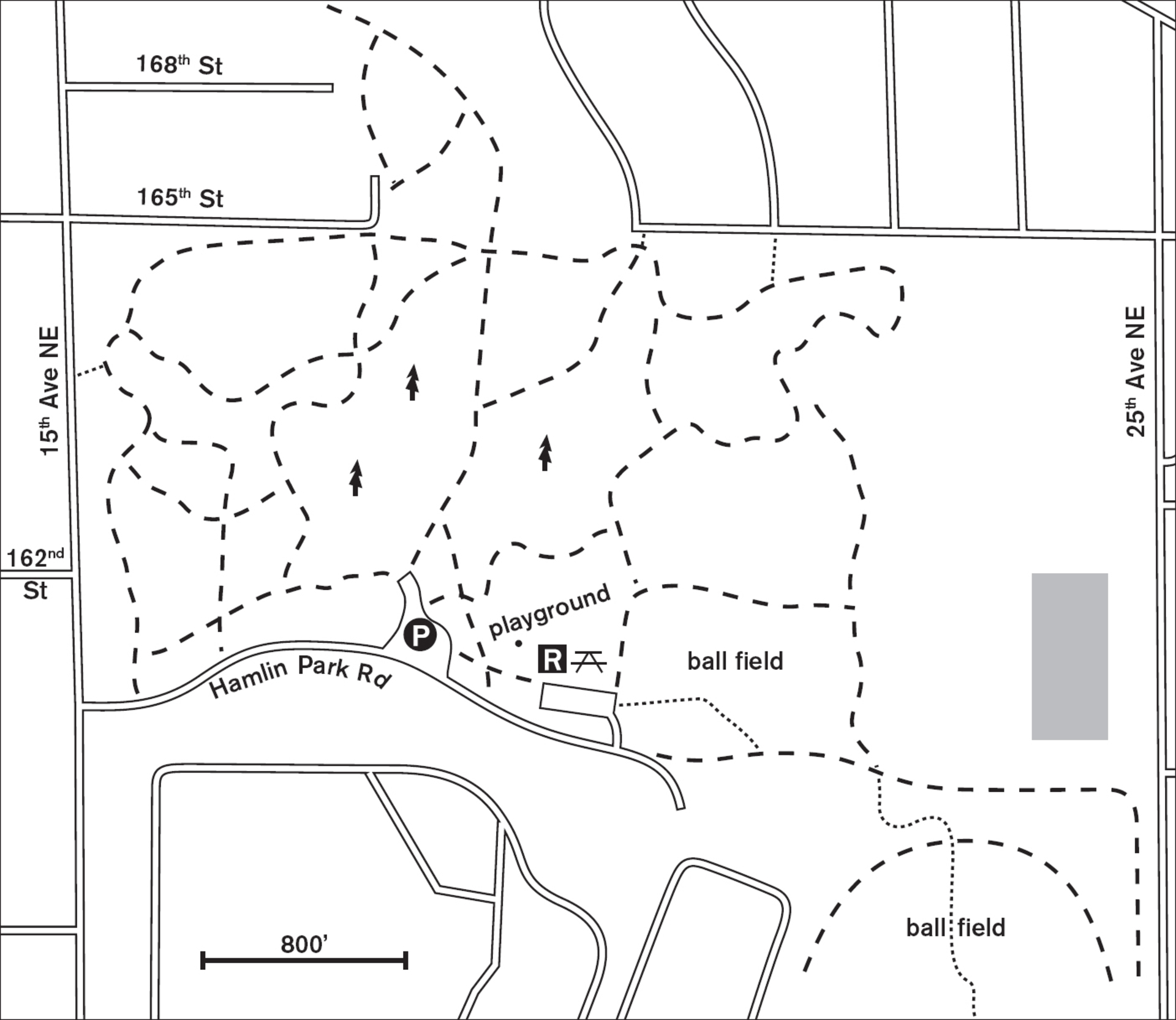
Step from your car and inhale air redolent with the scent of cedar wood chips. Follow wide, well-maintained trails into a dream forest of open glades, rolling hills, ravines with stairs cut into them, and fern-decorated slopes. A stroll in Hamlin Park can be an easy meander along almost level paths or a heart-stimulating walk up and down the three 50- to 80-foot-deep ravines that divide the park under glades of pines, hemlock, dogwood, and cedar. The wood-chip pile is testimony to the ongoing efforts of the Shoreline maintenance crew to keep this beautiful forest accessible to foot traffic by clearing downed trees and branches.
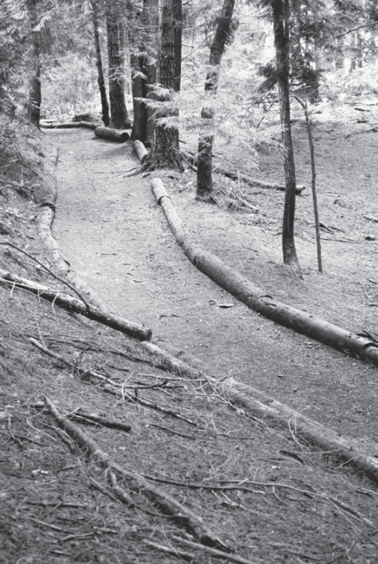

In our Northwest of dense, dark forests with tangled undergrowth, Hamlin is unprecedented for its lack of understory beneath towering trees. But beautiful as it is, the parks people would prefer an even more natural setting, and to this end they are experimenting with reintroducing native herbs and shrubs in a large fenced-off regeneration area. Elsewhere, salal and sword fern grow in comely bunches between log-lined trails and next to wood-rimmed steps, giving this park a feeling of a manicured forest, a place where it seems bright even on the darkest days.
Out of the forest, in the park’s southern region, you’ll find a strange couple of historic relics: two eight-inch naval canons from the Spanish-American War, said to have fired the first shots in Manila Bay in 1898. Just how and why they were taken off the USS Boston and transported to Seattle (before Shoreline was Shoreline) seems a bit of a mystery. Hamlin has the requisite playground and restrooms as well as a sculpture that visitors can sit on (Dew Beads, glass and concrete balls evoking dewdrops in the forest) and playing fields, ready for shouts and cheers in baseball season.
ADDRESS: 16006 15th Avenue NE, Seattle
GETTING THERE: From I-5, take exit 175 (NE 145th Street). Go east on 145th for 0.5 miles to 15th Avenue NE. Turn left onto 15th and go 0.9 miles to 160th Street. The park entrance is on your right.
CONTACT: Shoreline Parks, Recreation, and Cultural Services Department; (206) 801-2600; www.shorelinewa.gov/government/departments/parks-recreation-cultural-services

21 CARKEEK PARK
8 miles north of downtown Seattle
Piper’s Creek winds through 216 acres of forest to Puget Sound and views of the Olympic Mountains.
| TRAIL | 6.1 miles; natural surface, paved |
| STEEPNESS | Gentle to moderate |
| OTHER USES | Bicycles |
| DOGS | On leash |
| CONNECTING TRAILS | None |
| PARK AMENITIES | Restrooms, picnic shelters, playgrounds, Environmental Learning Center, model airplane field, demonstration garden |
| DISABLED ACCESS | Salmon-to-Sound Trail, Wetland Trail, part of Piper’s Creek Trail, restrooms |


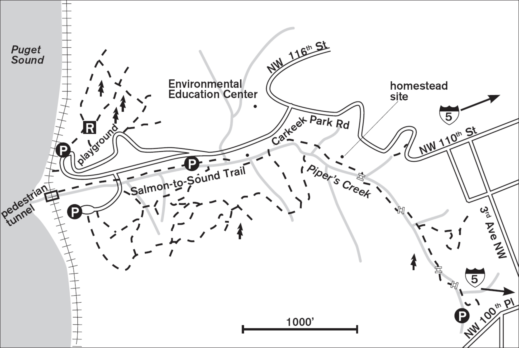
Leave commercial Seattle behind as you wind down either a road or a footpath into this verdant ravine, where moss clings to the big-leaf maples and old logs straddle Piper’s Creek. Like other ravines along Puget Sound, this one enchants with the steady downward flow of several small streams, the surprising gurgles of miniature waterfalls, and the profuse undergrowth of the forest. Salmon still spawn in this urban stream.
In spring the trailside is lush with salmonberry bushes, the fruit still yellow and orange, awaiting the summer sun. Incredibly large stumps, too big to hug, provide nutrients for young salal bushes and Douglas firs. But all is not wild here. The old orchard remains as testimony to the early settlers, A. W. Piper and his wife, Minna, who supplied produce to downtown Seattle from this homestead in the late 1800s.
A beautiful demonstration garden is now flourishing thanks to the ministrations of a score of volunteers. Look for this horticultural gem near the upper entrance to the park.
In the lower parking area, look for the stairs leading up to the footbridge that crosses over the train tracks to the watery world of Puget Sound. The sound of whinnying robins is replaced by the call of gulls, and your eyes are no longer drawn to branches overhead but farther away to the lofty Olympics in the west, or to your feet, where the sand ripples under the retreating tide.
ADDRESS: 950 NW Carkeek Park Road, Seattle
GETTING THERE: From I-5, take exit 173 (Northgate Way/1st Avenue NE). From southbound, go right on N Northgate Way (which becomes N 105th Street). From northbound, turn left on 1st Avenue NE, then left on N Northgate Way and go under the freeway. Drive west and turn right on Greenwood Avenue N. Go 2 blocks and turn left on NW 110th Street (which becomes Carkeek Park Road and winds down to the lower parking lot). Gates close at 9:00 p.m.
To access the trail at the southeast end of the park, stay on N 105th Street as it veers left to become Holman Road NW. Turn right on 3rd Avenue NW. Go 1 block and turn left on NW 100th Place to reach the small picnic and parking area.
CONTACT: Seattle Parks and Recreation Department, (206) 684-4075, www.seattle.gov/parks

22 GOLDEN GARDENS PARK
11 miles northwest of downtown Seattle
With 88 acres over Puget Sound, you can traverse level forest trails, descend from a fern-filled forest to the beach, or peruse the beach and wetlands.
| TRAIL | 3.2 miles; natural surface |
| STEEPNESS | Gentle to steep |
| OTHER USES | Pedestrians only on upper trails |
| DOGS | Off-leash area in the upper park, otherwise leash and scoop |
| CONNECTING TRAILS | None |
| PARK AMENITIES | Picnic tables, restrooms, playground, interpretive signs |
| DISABLED ACCESS | Lower parking lot trail |


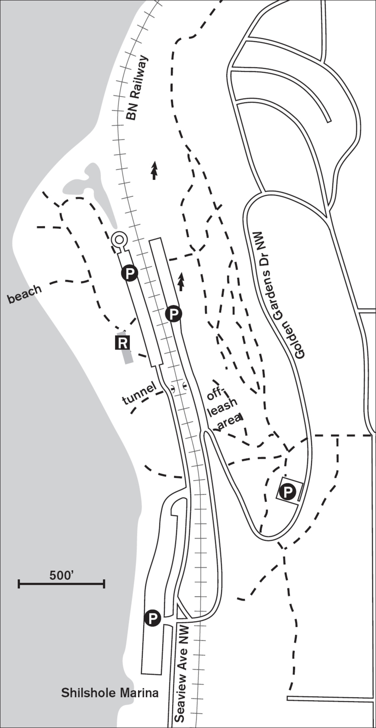
Traverse gently sloping forest trails where ferns line the hillside and big-leaf maples stand tall above the soft dirt pathway. Here, more than 120 feet above Puget Sound, you can almost sense the Seattle of old, before the regrades and hill sculpting tore down the steep wooded slopes. From the off-leash area at the upper parking lot, you can walk back and forth on gentle slopes or take one of several steep staircases built into the hillside either up to the neighborhood above or down to the lower parking lot and beach.
Known mostly as a summer play park, with beaches, lawn, and playground, Golden Gardens has so much more to offer. In winter, the spindly branches of the alders frame the brilliant white of the Olympic Mountains to the west, and through clear openings you can watch the ships and occasional courageous sailor on the Sound. In summer, the forest trails provide seclusion above the clamor of the playground, and you can hear the calls of the wrens and robins.


Near the lower parking lot, small wetland ponds create habitat for wintering birds such as gadwall, buffleheads, and mallards. And there is always the beach to wander, where the fresh salt air is a tonic for office-weary minds.
The Burlington Northern Santa Fe Railway runs through the park, and it is dangerous and illegal to cross the tracks. A pedestrian underpass is provided for safe passage from the upper and lower parking lots. Unlike other city parks, which close at sunset, Golden Gardens is open year-round until well after dark (see park signs, or call for hours), and beach fires are allowed.
ADDRESS: 8498 Seaview Place NW, Seattle
GETTING THERE: From I-5 northbound, take exit 172 (N 85th Street) toward Aurora Avenue N. Drive west on NW 85th Street for 3.2 miles. Turn right onto 32nd Avenue NW. Wind down the hill on Golden Gardens Drive NW. The forest trails and off-leash parking will be on your right. For the beach and lower trails, continue to the bottom of the hill and turn right on Seaview Place NW and into the parking lot.
CONTACT: Seattle Parks and Recreation Department, (206) 684-4075, www.seattle.gov/parks/. To volunteer at a Seattle park, call (206) 684-8028.

23 DISCOVERY PARK
6 miles northwest of downtown Seattle (Magnolia neighborhood)
Walk 534 acres of meadows, wetlands, forest, and beaches for views, bird-watching, art, and a historical lighthouse.
| TRAIL | 11.8 miles (including the 0.5-mile Wolf Tree Nature Trail and the 2.8-mile Loop Trail) plus 200-foot beach; gravel, natural surface, paved |
| STEEPNESS | Gentle to steep |
| OTHER USES | Bicycles on paved roadways only; pedestrians only on Loop Trail, Wolf Tree Nature Trail |
| DOGS | On leash; no dogs on Wolf Tree Nature Trail or the beach |
| CONNECTING TRAILS | None |
| PARK AMENITIES | Restrooms, classes, playground, picnic areas, sports courts, interpretive signs, maps, Daybreak Star Indian Cultural Center |
| DISABLED ACCESS | Restrooms, buildings, paved trail, pass available to drive to beach |


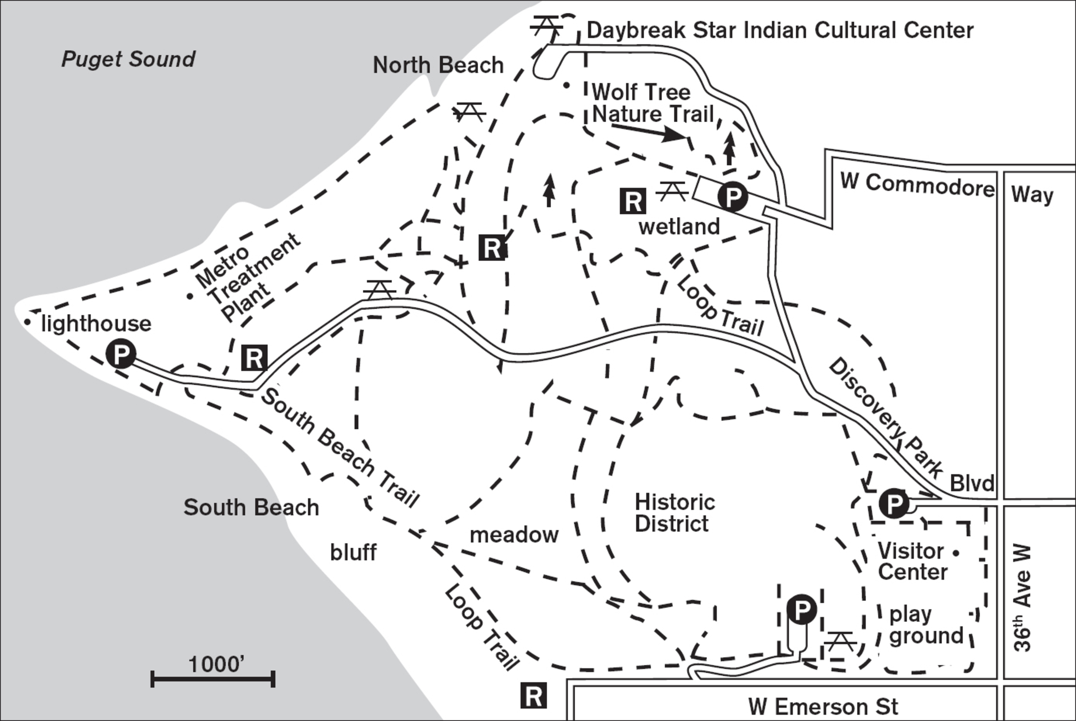
Walk a windswept bluff by a grassy meadow, hunt ghost shrimp on the Puget Sound beach, or search the treetops for an eagle’s nest. With more than 11 miles of trails to tread, Seattle’s largest park presents a variety of Northwest habitats to explore just minutes from downtown.
Start at the visitor center (east gate) for maps, then set off on the Loop Trail to the west. Crossing the flower-strewn meadow, watch for violet-green swallows in summer, or listen for the screech of hawks in winter. The old buildings are what remain of Fort Lawton, now recently converted to private homes with gated access.
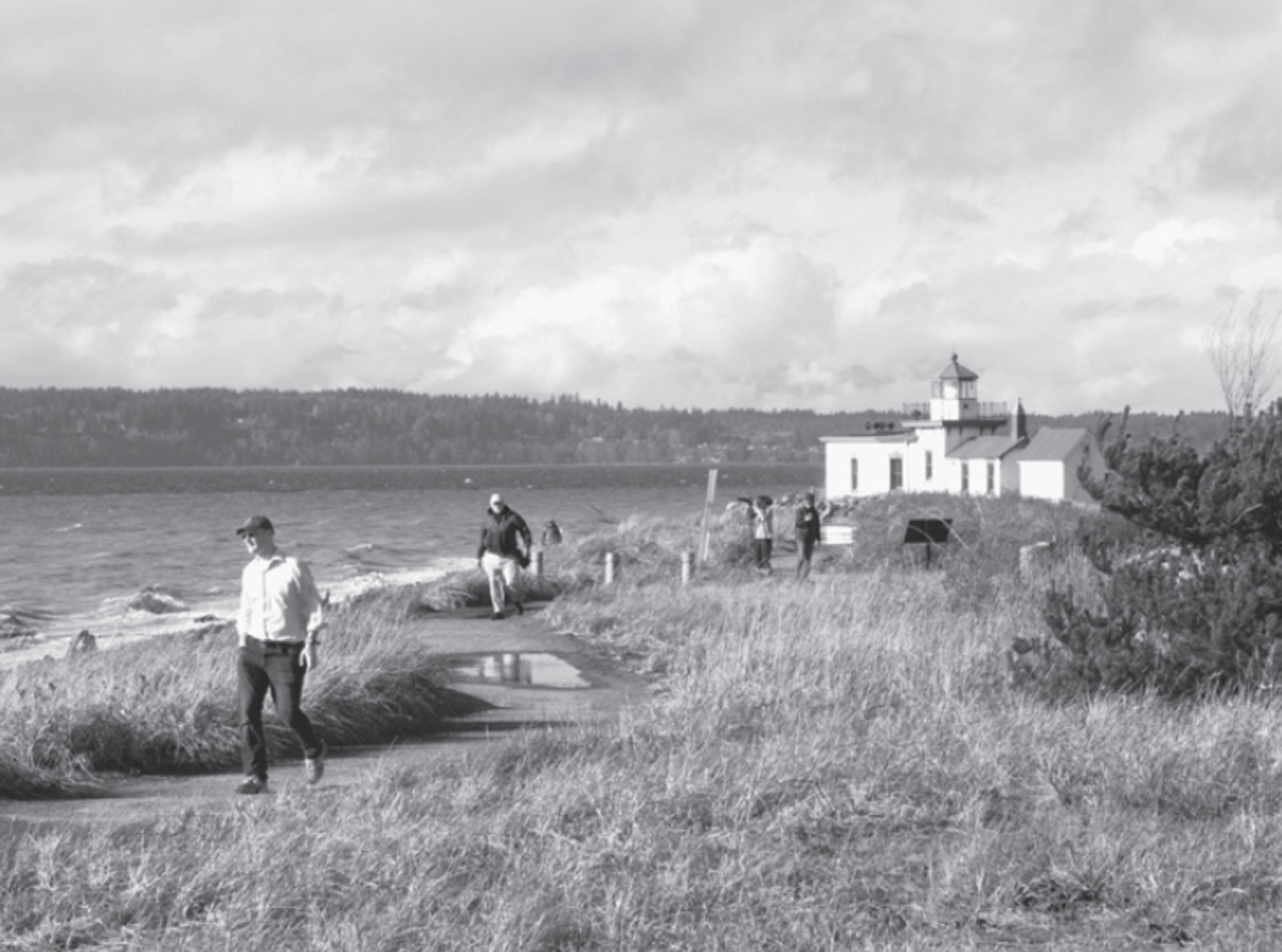

From the sandy bluff, listen for foghorns and the barks of sea lions, and watch the vessels ply the Sound far below. If the wind is from the south, head down the forested trail to South Beach (the goal being to stay upwind of the Metro sewage treatment plant on the headland). The trail is steep, with steps and observation platforms. Geology buffs can study the 300-foot cliffs for clues to our region’s glaciated past.
Back on the Loop Trail, stick to the larger, marked trails. Later, as you become familiar with the large park’s layout, you can explore the shortcuts and side trails with confidence. The Loop Trail takes you past the south entrance’s picnic area and playground before returning to the visitor center. At the north parking lot, leave time for the 0.5-mile Wolf Tree Nature Trail, which features interpretive signs and peaceful walking.
ADDRESS: 3801 W Government Way, Seattle
GETTING THERE: From I-5, take exit 169 (NE 50th Street/NE 45th Street). Turn west on NE 50th Street and go about 1.7 miles (past the zoo) until it merges right onto NW Market Street; continue west. Turn left on 15th Avenue NW, cross the Ballard Bridge, and take the first exit on the right (Fisherman’s Terminal/Emerson). Emerson merges to the right onto Gilman Avenue W; continue west. At W Fort Street, bear left; it becomes W Government Way and leads to the park’s east entrance.
Organized groups and cars with children under 7 or people over 62, or those with a state disabled permit, may be able to drive to the beach on the park’s access road; inquire at the visitor center.
CONTACT: Seattle Parks and Recreation Department, (206) 684-4075, www.seattle.gov/parks. For information on volunteering, visit www.friendsdiscoverypark.org. For information on the Daybreak Star Indian Cultural Center, call (206) 285-4425.

24 GREEN LAKE PARK
4.5 miles north of downtown Seattle
Green lawns and landscaping border the paved trail that circumnavigates placid 260-acre Green Lake.
| TRAIL | 2.8-mile loop; paved |
| STEEPNESS | Level |
| OTHER USES | Bicycles, in-line skaters (in designated lane) |
| DOGS | On leash |
| CONNECTING TRAILS | Woodland Park trails (south of lake) |
| PARK AMENITIES | Restrooms, picnic area, playground, beach, boating (nonmotorized), community center, concessions, fishing piers, sports fields, theater, wading pool |
| DISABLED ACCESS | Trail, restrooms, buildings, playground |


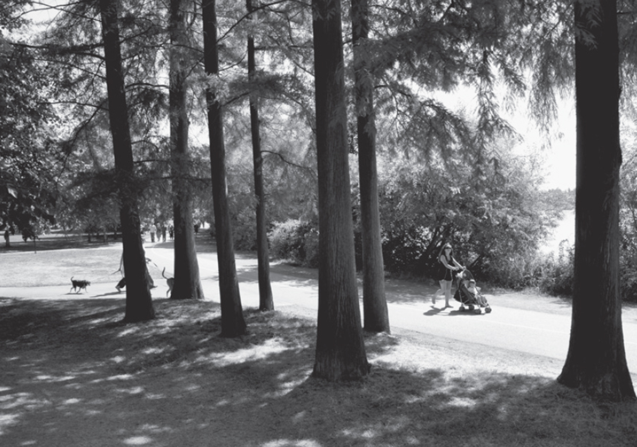
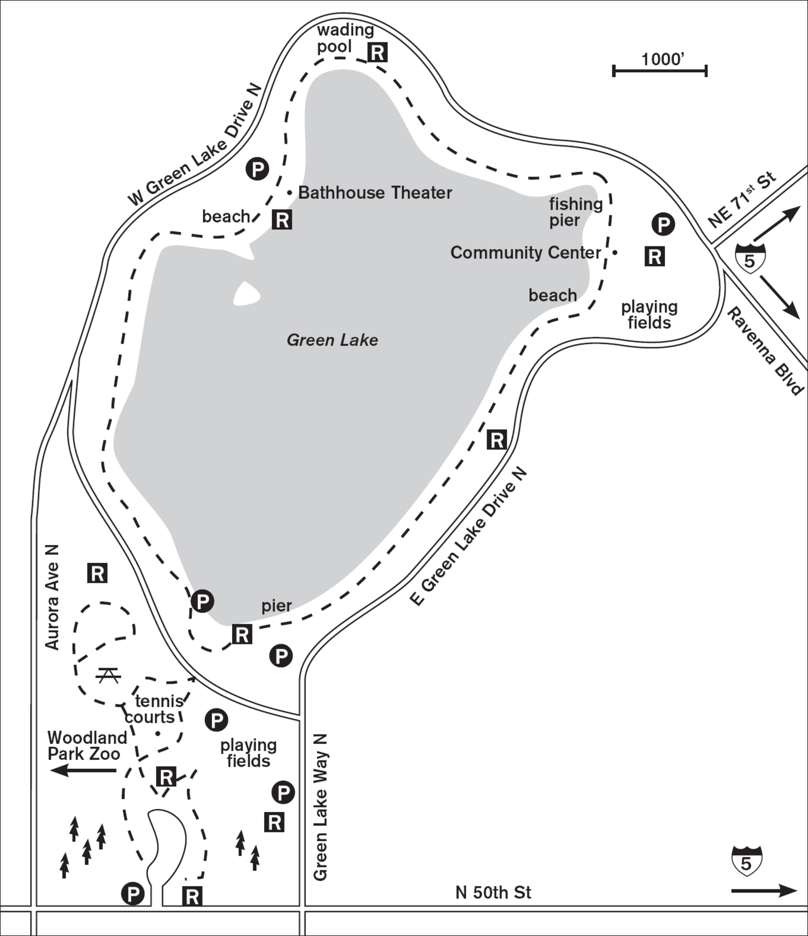
Circle this peaceful urban lake on a defined 2.8-mile paved trail and meet a cross section of Seattle life. Year-round, Green Lake attracts families, dog walkers, joggers, bicyclists, the old, and the young—all out to enjoy this strip of greenery in the 324-acre park. In spring, walk beneath flowering cherry and dogwood trees. In fall, look for the red berries on the hawthorns.
No matter the time of year, there is activity on the lake: in summer the paddle-boaters, small sailboats, and windsurfers; in winter the wind kicking up whitecaps. Two nature-preserve islands provide shelter for many birds but are inaccessible to walkers except through the magic of binoculars. Fall, winter, and spring are the best times to see the migratory birds such as buffleheads and white-fronted geese. Throughout the year, the omnipresent mallards and Canada geese forage in the reeds by the lake’s edge, and red-winged blackbirds add a splash of color to the scene.
Because of the paved trail’s popularity, traffic flow on it is regulated: walkers (including those with baby strollers) take the inside half and can travel either direction, while those on wheels must stick to a counterclockwise direction on the outer half. A crushed-gravel trail parallel to the paved path allows joggers and walkers to circle without encountering bicyclists.
ADDRESS: 7201 E Green Lake Drive N, Seattle
GETTING THERE: From I-5, take exit 169 (NE 45th Street/NE 50th Street) and head west on NE 50th Street. Go about 0.8 miles to Green Lake Way N, turn right, and park along the street by the lake or in lots farther north. Alternatively, continue west on NE 50th Street to park near the tennis courts (on the right). This also allows easy access to the wooded trails and hillsides of Woodland Park.
CONTACT: Seattle Parks and Recreation Department, (206) 684-4075, www.seattle.gov/parks

25 BURKE-GILMAN TRAIL
4 miles north of downtown Seattle (Ballard neighborhood) to Kenmore, 12 miles north of Seattle
Walk from park to park along Lakes Union and Washington via an old railroad grade.
| TRAIL | 16.5 miles one way; paved |
| STEEPNESS | Level to gentle |
| OTHER USES | Bicycles, in-line skaters |
| DOGS | On leash |
| CONNECTING TRAILS | Warren G. Magnuson Park and NOAA Art Walk (Walk #27), Sammamish River Trail (Walk #42) |
| PARK AMENITIES | Restrooms, beaches, picnic areas |
| DISABLED ACCESS | Trail, restrooms, picnic areas |


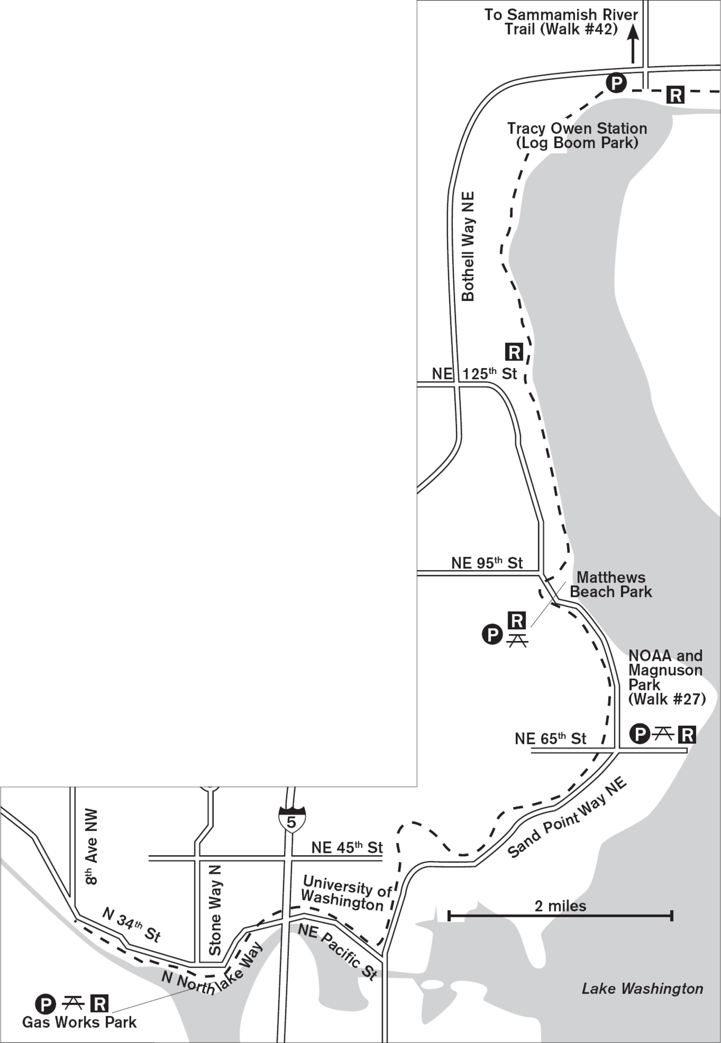
Beginning in the Ballard neighborhood of Seattle and snaking along the shore of Lake Washington to Kenmore, this 16.5-mile paved corridor of off-road walking meets the needs of those who seek the freedom of the trail just blocks from home.
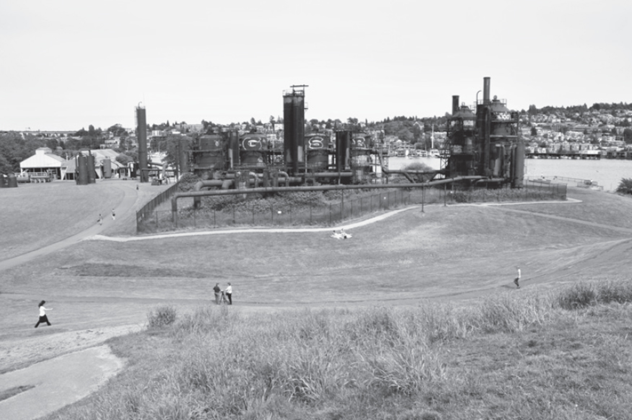
This wide, paved, multiuse trail follows the original grade of the Seattle, Lake Shore, and Eastern Railroad, which, after almost a century, was abandoned in 1971 under the ownership of Burlington Northern. Seven years later, Seattle opened the Burke-Gilman (named in honor of the original railroad’s founders) as an off-road multiuse trail. Near the western end, the trail passes Gas Works Park, a miniwalk in itself, with views of Lake Union and downtown Seattle, then continues east through the University of Washington campus and north past Warren G. Magnuson Park (Walk #27). Enjoy the fall colors of the hazelnut trees and big-leaf maples along this stretch.
North from here, increasing greenery lines the trail, which often runs between backyards that are well landscaped with both native and exotic trees and shrubs. You get peekaboo views of Lake Washington, but the best is saved for the far north. Blackberries line the trail, providing spring color and fragrance and summer snacking. Two miles past Log Boom Park (Tracy Owen Station) in Kenmore, the trail changes to the Sammamish River Trail (Walk #42). Here you can enjoy a beach, a green lawn, and views south across Lake Washington.
One warning: the trail is heavily used by bicyclists and in-line skaters. Always walk on the right—in single file if it’s a busy weekend. Toddlers and impatient children might do better on a quieter trail.
ADDRESS: Access at Warren G. Magnuson Park: 7400 Sand Point Way NE, Seattle; Access at Log Boom Park: 61st Avenue NE, Kenmore
GETTING THERE: The best access with parking: Warren G. Magnuson Park (see Walk #27), or Log Boom Park, Kenmore. Trail brochure shows other access points.
Log Boom Park: From I-5 northbound, take exit 171 (WA 522/Bothell/Lake City Way). Go north 6.5 miles, and in Kenmore turn right on 61st Avenue NE. The park is on the right.
From I-405 northbound, take exit 23 (WA 522 W/Bothell); southbound, take exit 23B (WA 522 W/Bothell). Go west on WA 522 about 4.4 miles, and turn left on 61st Avenue NE. The park is on the right.
CONTACT: Seattle Parks and Recreation Department, (206) 684-4075, www.seattle.gov/parks

26 RAVENNA PARK
5 miles northeast of downtown Seattle
Explore 50 acres of tranquil forest trails in a stream-cut ravine hidden from urban bustle.
| TRAIL | 4.5 miles total; natural surface |
| STEEPNESS | Level to steep |
| OTHER USES | Bicycles on 5-foot-wide paths only |
| DOGS | On leash |
| CONNECTING TRAILS | None |
| PARK AMENITIES | Restrooms, picnic tables, playground, tennis courts, wading pool |
| DISABLED ACCESS | Restrooms, playground at Cowen Park |



This secret cleft of choice greenery in the midst of urban Seattle offers some of the quietest, most treasured walking in the city. In fair weather, the steep side trails, the paths along the rims, and the wide trail in the ravine are filled with hikers, joggers, and dog walkers. Even in winter, when a dusting of snow coats the trail, footprints still tell of dedicated Ravenna-lovers out to enjoy their park despite slippery trails and a partially frozen stream.
One of Seattle’s oldest parks—acquired before the 1909 Alaska-Yukon-Pacific Exposition—Ravenna has seen bad years and good. Known at midcentury as a squatter’s haven, it was later cleaned up and has now become a magnet park for Seattleites.
From the massive footbridge (at 20th Avenue NE) over the ravine and the rim trails where wild roses and berry bushes bloom, you look out into the canopy of immense red alder and maple. As you descend the angled trails that traverse the hillside, the vegetation changes to a mix of native and ornamental trees (yew, redwood, Pacific dogwood, Douglas fir) sheltering an undergrowth of fern and salal. Leaning madrona trees form intricate patterns with their peeling bark branches.
Once in the ravine, you have no sense of city, no sight of houses. The stream flows from west to east, heading for Lake Washington. Working its way around boulders and logs, it brings nutrients to the skunk cabbages and stream creatures that live in its water and along its banks.
ADDRESS: 5520 Ravenna Avenue NE, Seattle
GETTING THERE: From I-5, take exit 169 (NE 50th Street/NE 45th Street) and head east on NE 50th Street. Turn left (north) onto 11th Avenue NE, then, in 4 blocks, turn right onto (divided) Ravenna Boulevard. Go 3 blocks to Brooklyn Avenue NE and park on the street near Cowen Park; walk up Cowen Place NE to the western edge of Ravenna Park. You can also continue east on NE Ravenna Boulevard to the recreational end of Ravenna Park.
Alternatively, from I-5 northbound only, take exit 170 (Ravenna Boulevard/NE 65th Street) and go right on Ravenna Boulevard to Cowen Park.
CONTACT: Seattle Parks and Recreation Department, (206) 684-4075, www.seattle.gov/parks


27 WARREN G. MAGNUSON PARK AND NOAA ART WALK
8 miles northeast of downtown Seattle
Enjoy 320 acres of beaches, meadows, Cascade views, art, and an off-leash area along Lake Washington.
| TRAIL | About 3 miles total; gravel, natural surface, paved |
| STEEPNESS | Level |
| OTHER USES | Bicycles; NOAA trail is pedestrians only |
| DOGS | Off-leash area, otherwise on leash |
| CONNECTING TRAILS | Burke-Gilman Trail (Walk #25) via streets |
| PARK AMENITIES | Restrooms, art, boat launch, picnic areas, playground, ball fields, tennis courts, wading pool, off-leash area |
| DISABLED ACCESS | Shoreline trail in Magnuson Park, restrooms, picnic areas |


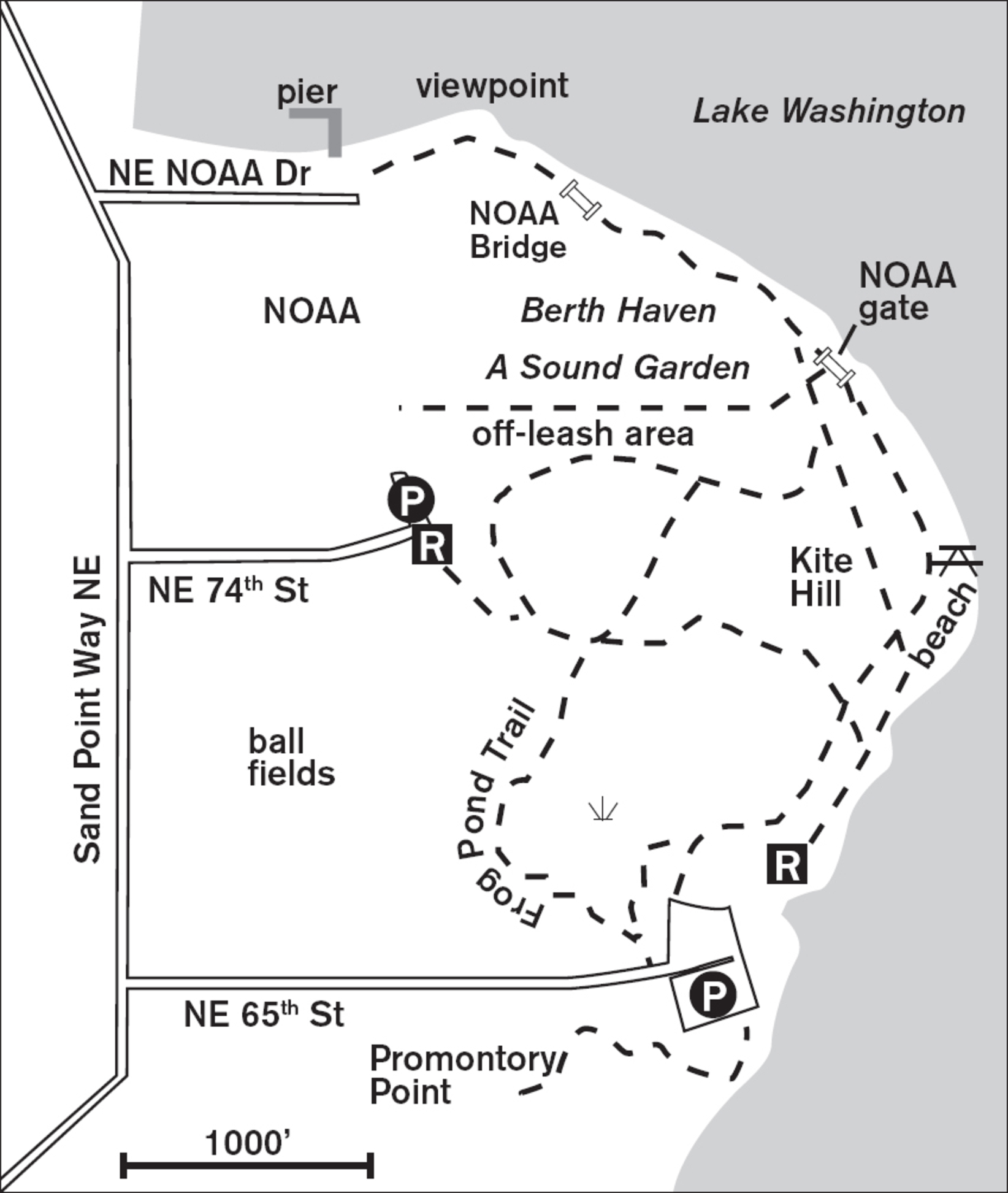
Still called Sand Point from its former days as a naval station, Magnuson Park is one of the brightest parks in the Seattle area, with miles of open meadows and lakeshore walking. Purchased from the navy in 1975, the park has seen years of improvement since the bleak days when it smelled of aviation fuel. To increase the greenery, the city originally planted trees, many of which died from lack of water. Now the park’s pastoral setting is part of its allure, and any future plantings call for native shrubs, not trees. Only the southern end has a forested hillside with dirt trails; elsewhere, be prepared for sun and wind.
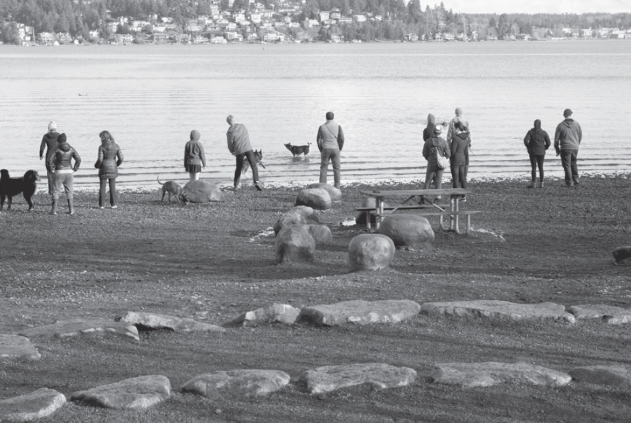

Blustery days offer entertainment as you walk the wide aggregate trail from south to north. Windsurfers and wakeboarders race from the headland onto the wind-whipped lake, and kite-flying aficionados wrestle with their colorful winged creatures from the hillock.
If you come with a dog, follow signs to the northwestern border of the park, where the designated off-leash area is rimmed by luscious summer blackberry thickets. This trail meanders past the playing fields and rejoins the paved aggregate walkway where it meets Lake Washington.
North of the off-leash area a fence marks the boundary of the National Oceanic and Atmospheric Administration (NOAA). Due to heightened security the gate on the northeast corner is opened to the public from 11:30 a.m. to 1:30 p.m. Monday through Friday only, or you can walk into NOAA grounds via the main gate from 9:00 a.m. to 5:00 p.m. Monday through Friday. To enter, you need to show a valid ID and undergo a security check (no picnic baskets or large containers are allowed). Dogs are allowed on-leash. Five art-in-the-parks projects here enhance the waterside graveled walk. Stroll across two bridges inscribed with quotes from Moby-Dick, enjoy views over the lake at Berth Haven and Viewpoint Terrace, guess the artist’s intentions for the conical Knoll for NOAA, and walk through a haunting, moaning, otherworldly symphony of wind in A Sound Garden.
ADDRESS: 7400 Sand Point Way NE, Seattle
GETTING THERE: From I-5, take exit 169 (NE 45th Street/NE 50th Street). Drive east on NE 45th Street past the University of Washington, down the viaduct, and another 0.5 miles. Bear left onto Sand Point Way NE. Turn right on NE 65th Street or NE 74th Street into Magnuson Park. The NOAA Art Walk extends north from Magnuson Park.
CONTACT: Seattle Parks and Recreation Department, (206) 684-4075, www.seattle.gov/parks. To volunteer, contact Magnuson Environmental Stewardship Alliance: www.magnusonstewardship.org. For more information on the NOAA Art Walk, visit www.wrc.noaa.gov.

28 UNION BAY NATURAL AREA
5 miles northeast of downtown Seattle
Resident and migrating birds abound among 74 acres of meadows, wetlands, and ponds on Lake Washington.
| TRAIL | 1.5 miles total with loops north and south; gravel, natural surface |
| STEEPNESS | Level |
| OTHER USES | Bicycles except on Yesler Swamp Trail |
| DOGS | On leash |
| CONNECTING TRAILS | None |
| PARK AMENITIES | Restrooms (weekday only), picnic tables, botanical garden, interpretive signs |
| DISABLED ACCESS | Trails, Yesler Swamp, restrooms (weekday only) |


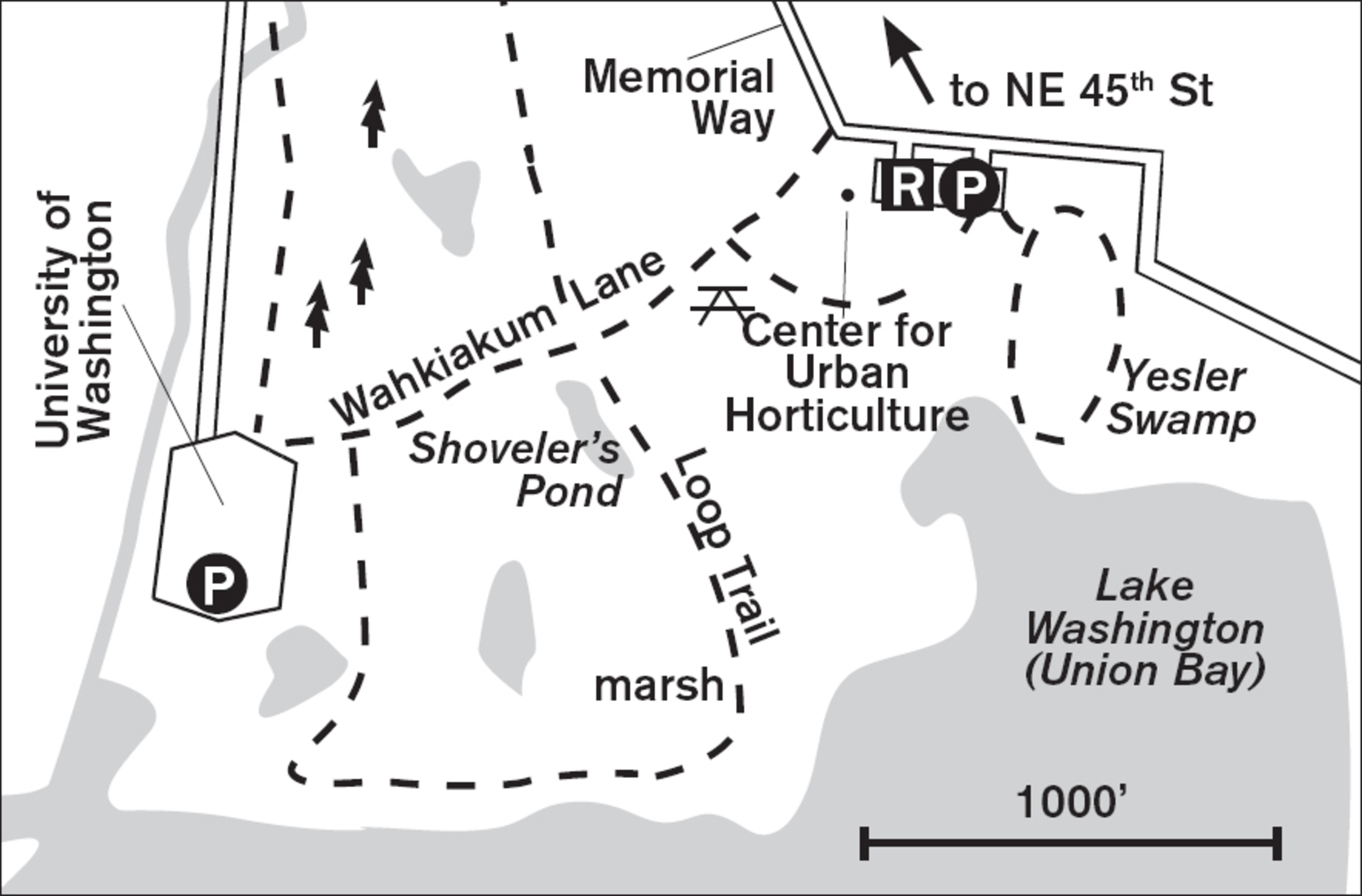
This swath of untamed greenery between the University of Washington’s Husky Stadium and the Center for Urban Horticulture is a stopover for thousands of migrating waterfowl and other birds on the Pacific Flyway. Come during fall, winter, or spring, when the ponds may host ruddy ducks, hooded mergansers, and green- or blue-winged teals. The trees and bushes may be dotted with goldfinches, vireos, and waxwings. In summer the meadows are bright with yellow Scotch broom and blue chicory. All year long, mute swans glide on the calm waters of Union Bay, while Swainson’s hawks hunt overhead and muskrats make their homes in Shoveler’s Pond.

Before 1916 this was another cove of Lake Washington, but when the ship canal was built the water receded and the land slowly adapted to its dry status. It’s now an ecological research area, and walkers are welcome provided they keep pets on a leash and walk only on established paths.
From Wahkiakum Lane, take the first left onto a wood-chip trail, which passes the seasonal Shoveler’s Pond (dry in summer) and then crosses the meadow to the lakeshore. Stay alert for ring-tailed pheasants in the grass and the shadow of eagles overhead. Several small paths weave through the cattails at the water’s edge. In summer these are practically impassable due to blackberry invasion, but in winter you can find tiny clearings from which you can watch the lake-loving waterfowl.
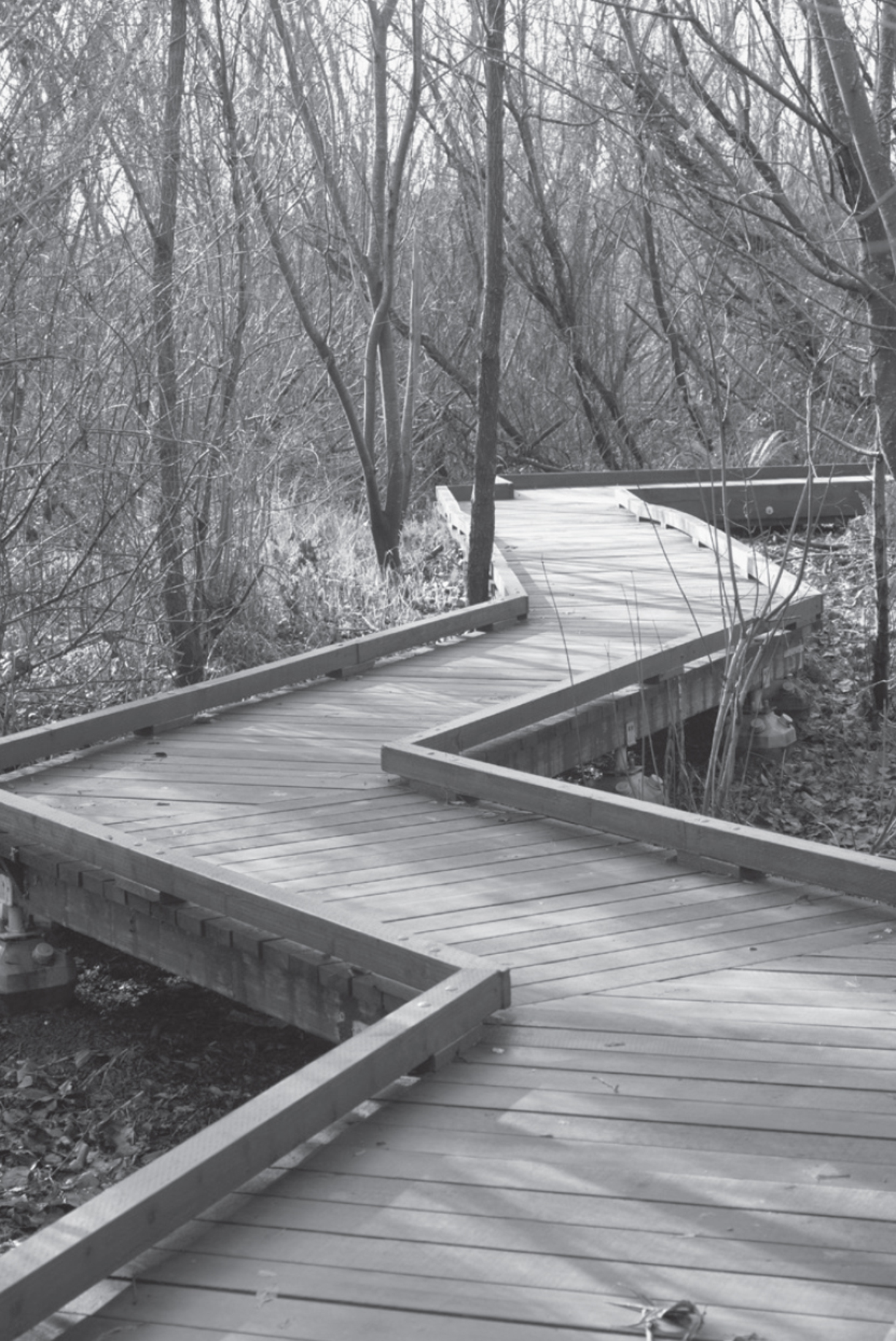
Continue on the paths around the other ponds, where you may see plovers and bitterns. New plantings of dogwood and other trees enhance the seclusion and help ensure the repeated return of the seasonal migrants. To the east of the parking lot Yesler Swamp is now ADA compliant. Boardwalks lead you to viewpoints in the wetlands by the lake. Union Bay is a walk for nature observers and for those who find pleasure in the wildlife surprises that each walk brings.
ADDRESS: 3501 NE 41st Street, Seattle
GETTING THERE: From I-5, take exit 169 (NE 45th Street/NE 50th Street). Drive east on NE 45th Street and go past the University of Washington and down the viaduct, staying on NE 45th Street. Turn right on Mary Gates Memorial Way following signs to the Center for Urban Horticulture (CUH). The longer preserve walk starts to the west of the parking lot, and Yesler Swamp Trail to the east.
From WA 520 westbound, take the exit for Montlake Boulevard NE and go north. Stay right, passing Husky Stadium and merging with NE 45th Street heading east. Turn right on Mary Gates Memorial Way and proceed as above.
CONTACT: University of Washington Center for Urban Horticulture, (206) 543-8616, http://depts.washington.edu/uwbg/visit/cuh.php. For information on volunteering, visit www.yeslerswamp.org.

29 WASHINGTON PARK ARBORETUM
4 miles east of downtown Seattle
Birds and botanical treasures abound in gardens and wetlands in this 194-acre park along Lake Washington.
| TRAIL | Waterfront 0.5 miles one way, garden paths at least 4 miles; natural surface |
| STEEPNESS | Level to gentle |
| OTHER USES | Bicycles on paved roads only |
| DOGS | On leash; not allowed in Japanese Garden |
| CONNECTING TRAILS | None |
| PARK AMENITIES | Restrooms, playground, classes, flower shows, gift shop, interpretive trail, Japanese Garden (admission fee), visitor center |
| DISABLED ACCESS | Azalea Way (when dry), restrooms, visitor center |


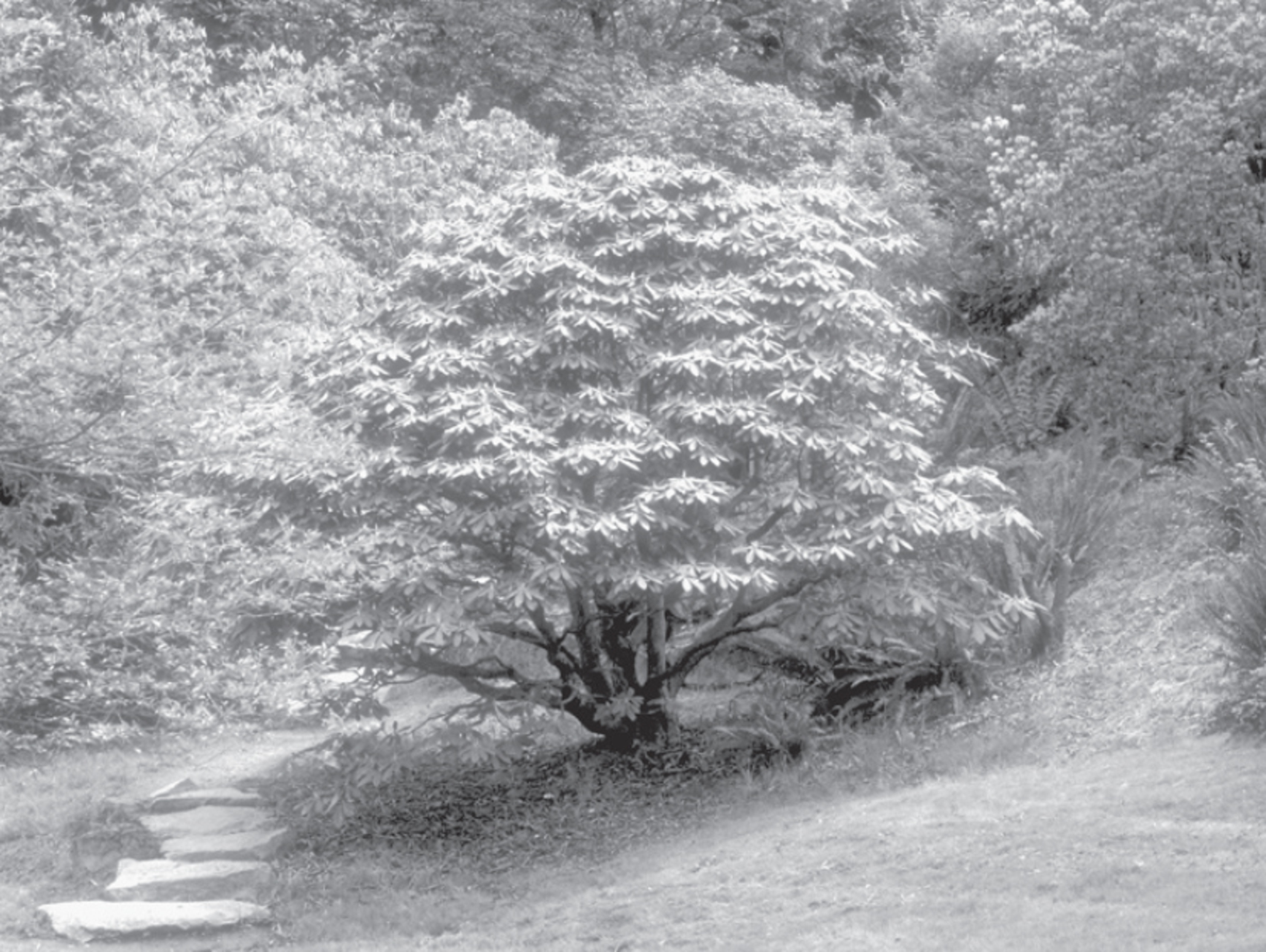
With each season, color lures you deeper into the graceful elegance of the arboretum. Spring and summer bring an explosion of pink and white cherry blossoms; red, purple, and yellow rhododendrons; pink and white camellias; and an artist’s palette of other perennials. Fall’s warm tones of orange and yellow brighten the trails. Even in winter, the myriad colors of bark, foliage, and winter berries contrast cheerfully with the drab days; as you walk, look for the striped maples, the tiger bark of the cherry trees, and the sinewy shapes of trees and shrubs.

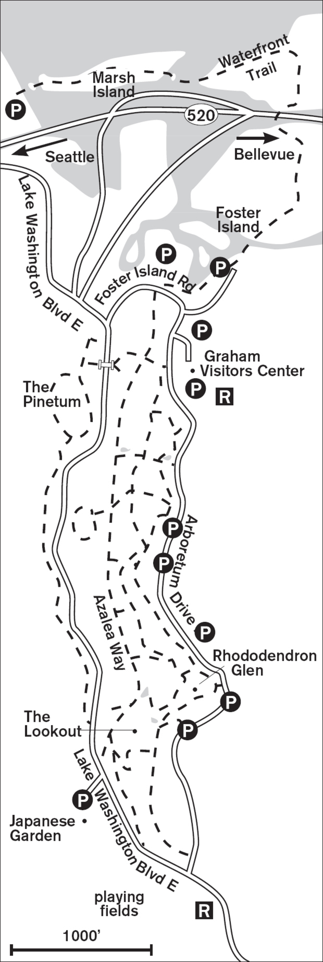
First-time visitors may want to get a free map of this 194-acre park from the Graham Visitors Center and then set off on Azalea Way, taking small side trips into specialized gardens such as the Winter Garden, the Rhododendron Glen, and the Woodland Garden. Meander over paths on hillsides planted with exotic trees and shrubs. Cross the old stone bridge to the Pinetum for the pungent scent of fir and pine.
Along the Waterfront Trail bordering Lake Washington, birds abound. Here you’ll find mallards, coots, and grebes. In spring the tree swallows swoop and dive for insects above the marsh and in the evenings return to their nesting boxes along the trail. Canada geese nest on the hummocks beneath the reeds and cattails. Test your knowledge of marsh plants with the self-guiding tour booklet that illustrates many of the common plants seen here. Whatever your reason for walking, this mature and well-loved park, dating back to 1934, provides constantly changing botanical treasures on its interlacing trails.
ADDRESS: 2300 Arboretum Drive E, Seattle
GETTING THERE: From I-5, take exit 168B (WA 520/Bellevue). Take the first exit (Montlake) from WA 520. Cross Montlake Boulevard NE and wind down the hill to the junction with Lake Washington Boulevard E. Turn right onto the boulevard and then left onto Foster Island Road. As you wind past several parking areas, Graham Visitors Center is on your left; free park maps are available.
From WA 520 westbound, take the Lake Washington Boulevard exit. The ramp turns left over the freeway; at the junction with Lake Washington Boulevard E, turn left. Take the next left onto Foster Island Road and proceed as above.
CONTACT: The Graham Visitors Center, (206) 543-8800, www.uwbotanicgardens.org. Call for volunteer opportunities.

30 INTERLAKEN PARK
4.5 miles east of downtown Seattle
Find 52 acres of forested ravines teeming with birds and astounding views from Volunteer Park.
| TRAIL | About 1 mile round-trip; natural surface, paved |
| STEEPNESS | Gentle (paved trail) to steep (natural trails) |
| OTHER USES | Bicycles |
| DOGS | On leash |
| CONNECTING TRAILS | Via short road walk, pathways in Volunteer Park and, when open, Lake View Cemetery |
| PARK AMENITIES | Benches |
| DISABLED ACCESS | Paved road (closed to vehicles)—caution: may not meet ADA requirement for a slope of less than 10 percent |


Listen for the drumming of pileated woodpeckers or the chatter of squirrels as you stroll a historical greenbelt in the heart of Seattle. Interlaken is a birding hot spot hosting robins, bald eagles, osprey, juncos, pine siskins, flickers, owls, hummingbirds, and more. A bird list is posted at the trailhead.
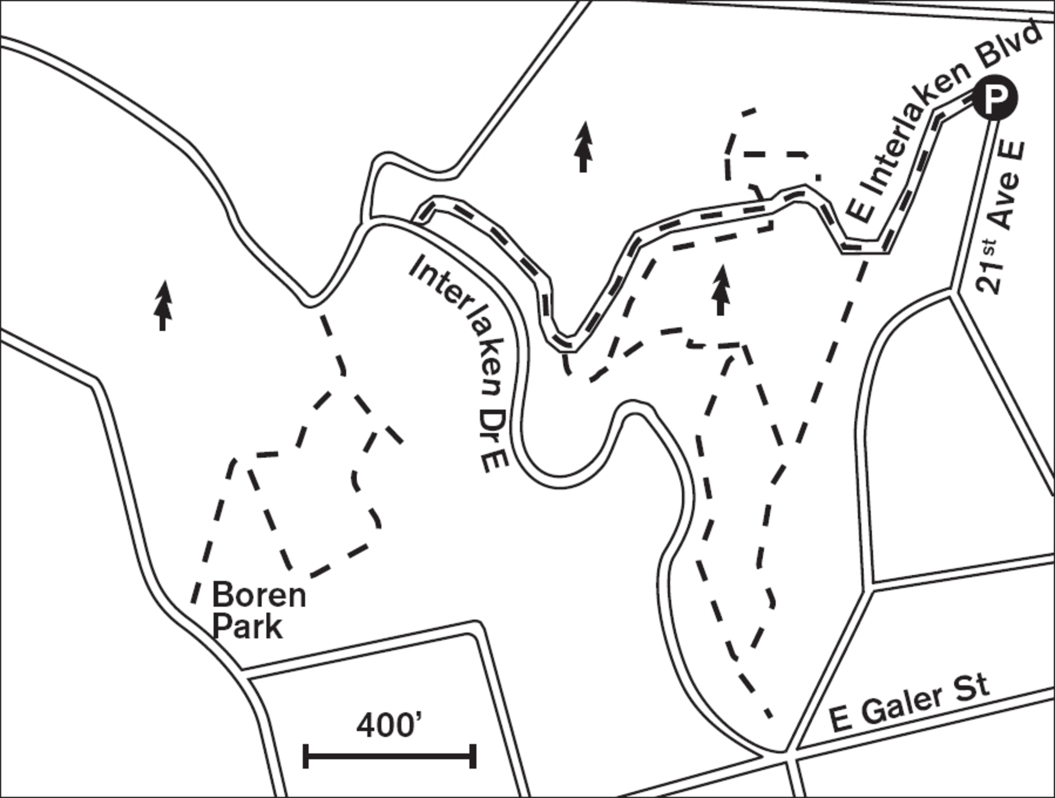
Recommended by the Olmsted brothers for preservation in 1903, Interlaken’s forest and ravines boast remains of the region’s original evergreen forest. You can walk the gently inclined paved road or climb one of several steep renovated footpaths. Crossing streams, ravines, and hillsides, these paths with an occasional bench for resting offer good exercise and reward hikers with expansive city views. One primitive side trail joins the road at the corner of 19th Avenue and Interlaken Drive E, with more trails in Boren Park.
The Friends of Interlaken Park have been working to restore the trails and remove invasive plants such as English ivy, blackberry, and clematis. They request that hikers stick to the main trails and avoid the shortcuts. Separated by lush forest from the traffic of Interlaken Drive E, this hillside greenbelt offers silence and nature study with views over Husky Stadium and the Montlake Cut.
Although maps show a continuous greenbelt running west from Washington Park Arboretum (Walk #29) to Volunteer Park, the best walking is from the trailhead at the corner of Interlaken Place E and 21st Avenue E to the junction with Interlaken Drive E. Turn left on the drive and follow the road for 0.5 miles to the historical marker and trailhead for Boren Park. Leave the road and switchback up a shrub- and forest-covered hill to tiny Boren Park with its tall sculpture, benches, and great views.
If you want to extend your walk, cross 15th Avenue E and enter serene Lake View Cemetery. Perched atop Capitol Hill, with views in all directions, this pioneer cemetery welcomes the public during daylight hours. If the cemetery walk is not your thing, go south a block to Volunteer Park for another mile of strolling.
ADDRESS: 2177 E Interlaken Boulevard, Seattle
GETTING THERE: From I-5, take exit 168 (WA 520). Take the Montlake Boulevard exit off WA 520. Turn right onto Montlake Boulevard and go south. It becomes 24th Avenue E. Go 0.5 miles and turn right on Interlaken Boulevard. The trailhead is on the right in about 3 blocks, where the road turns sharply left at 21st Avenue E.
CONTACT: Seattle Parks and Recreation, (206) 684-4075, www.seattle.gov/parks. For information on volunteering, visit www.greenseattle.org, call (206) 684-8028, or e-mail parksvolunteer@seattle.gov.



31 THE GRAND FOREST
Bainbridge Island, 12.5 miles west of Seattle (with ferry ride)
A maze of quiet forest trails in three sections offers bird-watching and streamside solitude in these 240 acres.
| TRAIL | 7 miles; natural surface |
| STEEPNESS | Gentle to steep |
| OTHER USES | Bicycles, horses |
| DOGS | On leash |
| CONNECTING TRAILS | 1.5-mile Forest to Sky Trail to Battle Point Park |
| PARK AMENITIES | Picnic area, limited parking |
| DISABLED ACCESS | None |


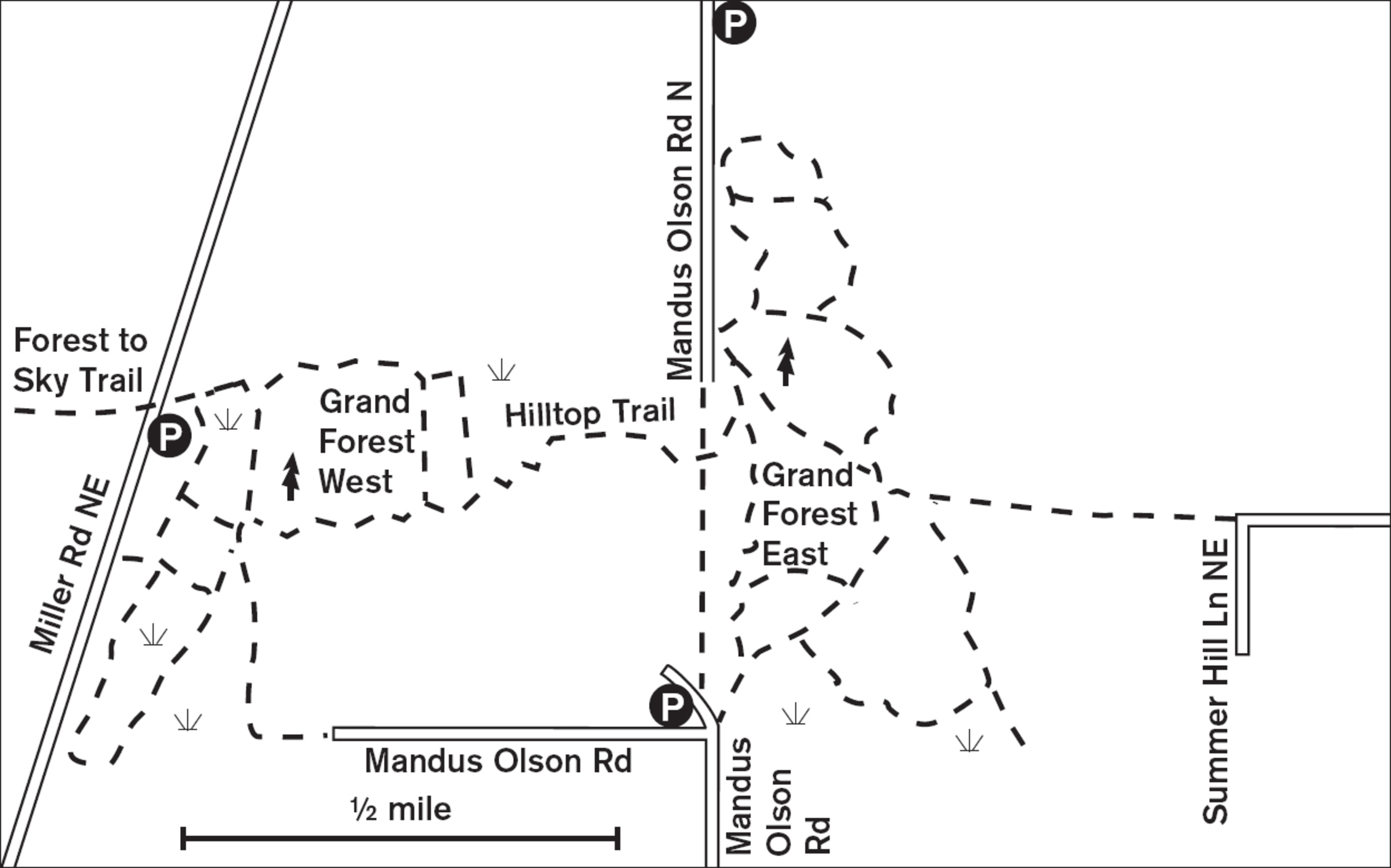
Soft dirt trails quilt this open forest of Douglas firs in large, easy loops. Silence is broken by the sudden birdlike chatter of the tawny Douglas squirrels that patrol the tree trunks and branches like overzealous guardians of the woods. Three separate areas compose Bainbridge’s Grand Forest, acquired from the Department of Natural Resources in 1990.
In the Mandus Olson block, called Grand Forest East, map signs along the trail with “You Are Here” dots help steer you around the loops. If your sense of direction is anything less than that of a migrating bird, you’ll be glad they’re there. So uniform is this forest that without the guidance of low, slanted sunshine it is easy to get turned around. In the southeastern corner a shallow ravine, a deep cradle of fern and shrub, extends to the east. Elsewhere, the understory shrubbery is low enough to give a clear view of the middle layer of pole-like trunks, characteristic of a farmed forest. Above it all spreads the upper story of Douglas fir boughs. With the openness comes great bird-watching possibilities: easy viewing to the tops of shrubs and a chance to see woodpeckers, nuthatches, and brown creepers on the trunks.
The Hilltop Trail now connects Grand Forest East to the trail system in the Grand Forest West section off Miller Road, just less than a mile away. Here in the west section you can explore a spiderweb of loops in a denser, more varied forest. Big-leaf maple and red alder mix with Douglas fir and western red cedar, and the eastern part is highlighted by a small stream and surrounding wetland. Two parallel trails lead north and south, with tributary paths joining them. Next to the westernmost one is a picnic table. Huge stumps border the trail, doing their work as nurseries for saplings.
The third section, known as Grand Forest North, has another 0.8 miles of trail to explore.
ADDRESS: Mandus Olson Road and 9752 Miller Road NE, Bainbridge Island
GETTING THERE: From the Bainbridge ferry head north out of Winslow on WA 305. To reach the Mandus Olson section, go 1.6 miles north and turn left on Sportsman Club Road. After the school, turn right on New Brooklyn Road. Go 1.3 miles and turn right on Mandus Olson Road. There is limited parking where the road makes a sharp left turn.
To reach the Miller Road section from New Brooklyn Road westbound, go 0.75 miles and turn right on Miller Road. Just past the Bainbridge Gardens nursery (on the left), at the top of a rise, look on the right for a sign for the Grand Forest. Two pullouts provide limited parking.
For the Grand Forest North section, there are several trailheads without parking. Head north on Miller Road; the first trailhead is just north of the northern parking area for Grand Forest West. Continue north to Koura Road, where there are a couple more trailheads.
CONTACT: Bainbridge Island Metro Park and Recreation District, (206) 842-3343, www.biparks.org

32 GAZZAM LAKE NATURE PRESERVE
Bainbridge Island, 14 miles west of Seattle (with ferry ride)
445 acres of towering mature forest surrounds placid Gazzam Lake, and trails lead to beaches on Puget Sound.
| TRAIL | 6.3 miles; natural surface |
| STEEPNESS | Gentle to moderate |
| OTHER USES | Bicycles, horses; pedestrians only on Peters Trail and Close Property |
| DOGS | On leash |
| CONNECTING TRAILS | Trails lead to Schel Chelb Park and southwest to the shore |
| PARK AMENITIES | Two small parking areas, information kiosks, trail signs |
| DISABLED ACCESS | None |


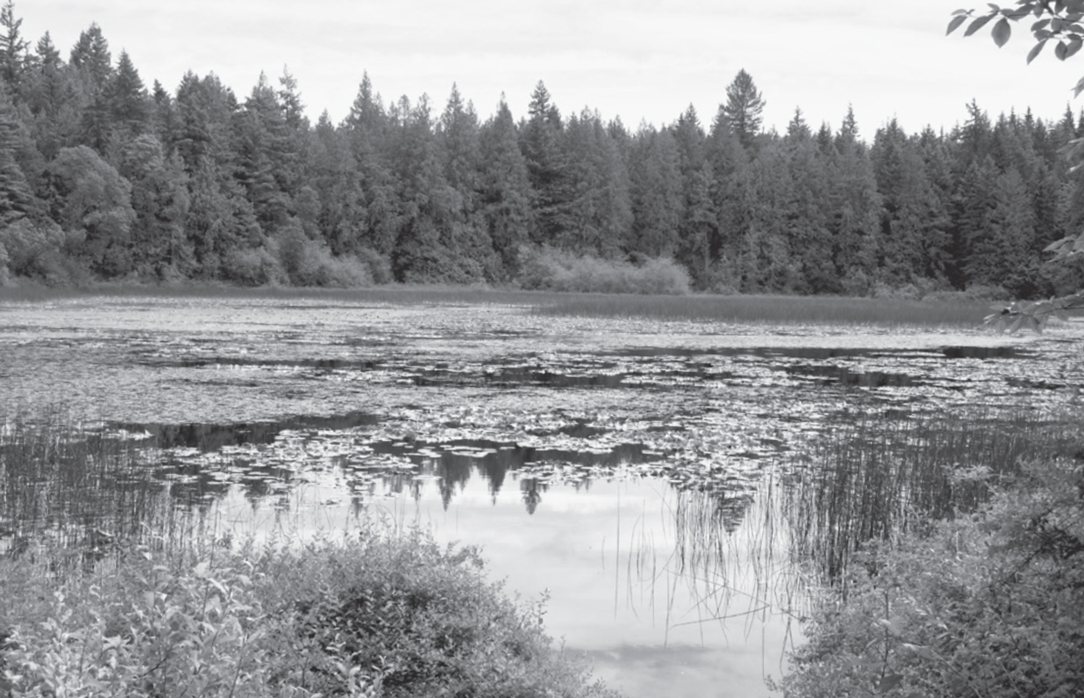

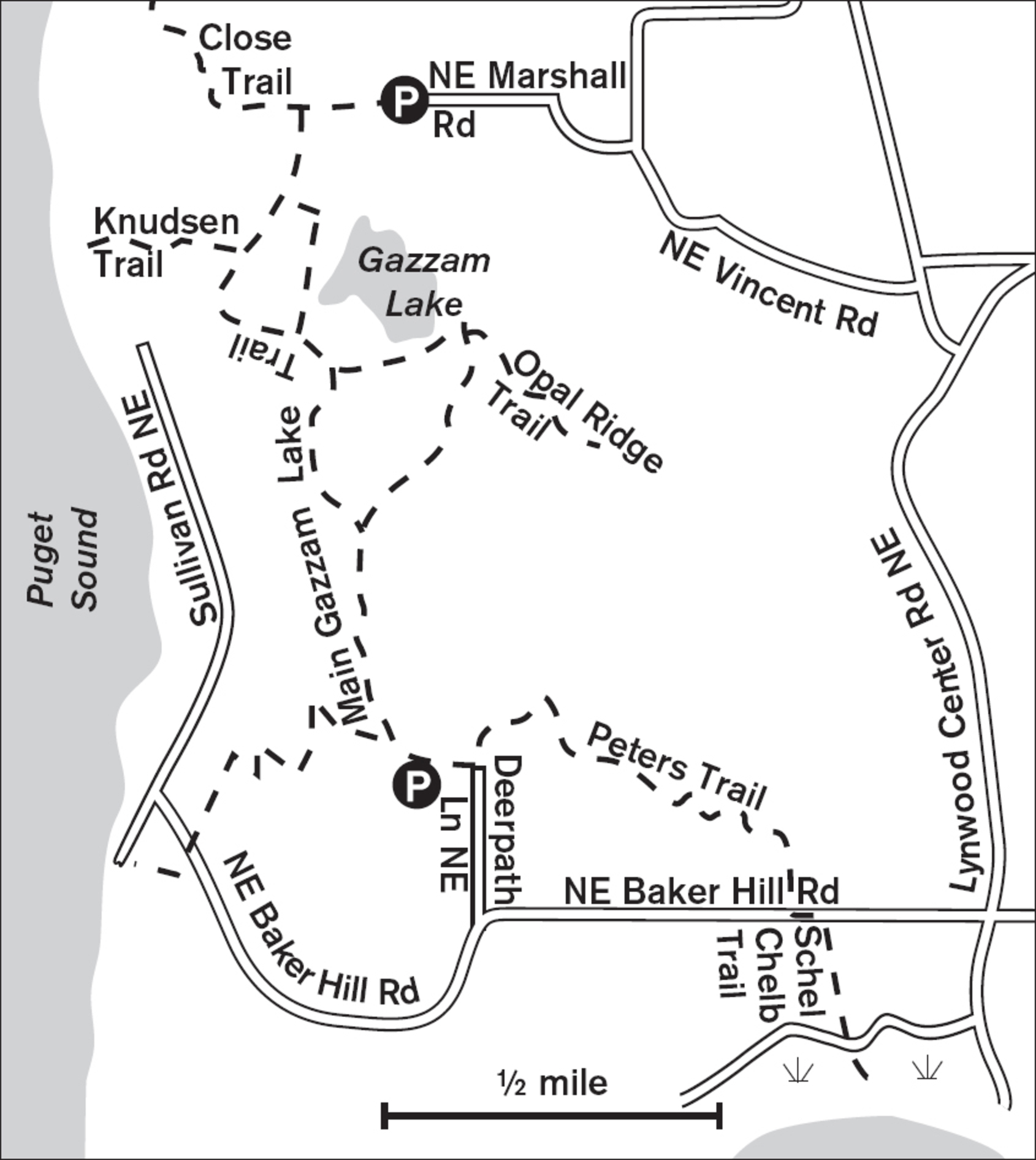
The buffering effect of near-pristine upland forest shields you from the sound of vehicles and allows the chirping, twittering, and chattering noises of small forest animals to resound. The logging history of the region is revealed in the immense moss-softened stumps, still scarred with ax cuts. The quiet, cushioned earth yields beneath your feet, like walking on the soft belly of Mother Earth. Sword ferns create a green and bushy understory. From either of the two trailheads, the path undulates gently, staying wide, and welcoming you near the edge of 13-acre Gazzam Lake, where a few spur trails lead you to the water’s edge. Swallows dive and swoop for mosquito meals, and in summer the native yellow water lilies burst forth. Closed to swimming, boating, and fishing, the lake remains an unspoiled habitat for beavers, muskrats, and river otters.
South of the Deerpath Lane parking area, the trail enters an extension of the Gazzam Lake Trail on Peters Property, heading south and downhill to meet the trail leading to Rich Passage. The newer almost 1-mile trail spur, the Gazzam to Veterane Trail, leads west to the sound. Back by the lake, a new spur trail heads up to a ridge. And north of Marshall Road the trail joins the Close Property, a 49-acre addition to the preserve. Well-engineered switchbacks lead down to a secluded beach on Puget Sound. Before the water comes into view, the forest’s scent changes from sweet, fresh water to the bite of salt air.
ADDRESS: Deerpath Lane NE or 6105 NE Marshall Road, Bainbridge Island
GETTING THERE: From the Bainbridge ferry, follow Winslow Way E 0.3 miles and turn right on Madison Avenue N. Take the first left onto Wyatt Way NW. Go 1 mile and turn left on Eagle Harbor Drive NE. Go 0.2 miles and take a slight right onto Bucklin Hill Road NE. This becomes Blakely Avenue NE. Go 1 mile and turn right at NE Baker Hill Road. Go 1.2 miles and turn right on Deerpath Lane NE, where you will find a trailhead on the left. No facilities.
For the Marshall Road trailhead, proceed as above, but after turning onto Bucklin Hill Road, take the first right (a continuation of Bucklin Hill Road). Go 1 mile and turn left at Fletcher Bay Road, then immediately right onto NE Vincent Road. Go 0.5 miles and turn left on NE Marshall Road. Limited parking.
CONTACT: Bainbridge Island Metro Park and Recreation District, (206) 842-3343, www.biparks.org

33 FORT WARD PARK
Bainbridge Island, 16 miles west of Seattle (with ferry ride)
Beaches and forest trails on 137 acres provide historic sites, bird-watching, and views of the Olympic Mountains.
| TRAIL | 3.3 miles; natural surface, paved |
| STEEPNESS | Level to steep |
| OTHER USES | Bicycles on paved shoreline path only, horses |
| DOGS | On leash |
| CONNECTING TRAILS | 1.25-mile Fort Ward to Blakely Harbor Trail |
| PARK AMENITIES | Restrooms, boat launch, campground, gun battery ruins, interpretive signs, picnic tables, underwater park, viewing blinds |
| DISABLED ACCESS | Paved shore trail (Pleasant Beach Drive), restrooms, picnic area, upper parking lot |


Although it was an extensive military holding in the early 1900s, not much remains of the original Fort Ward except the ruins of two gun emplacements. Today, the appeal of this Bainbridge Island park lies in its sylvan tranquility and water’s-edge walking, rather than its military history. In the dense second-growth Northwest forest, the ferns and towering big-leaf maples enclose walkers in a green cocoon.


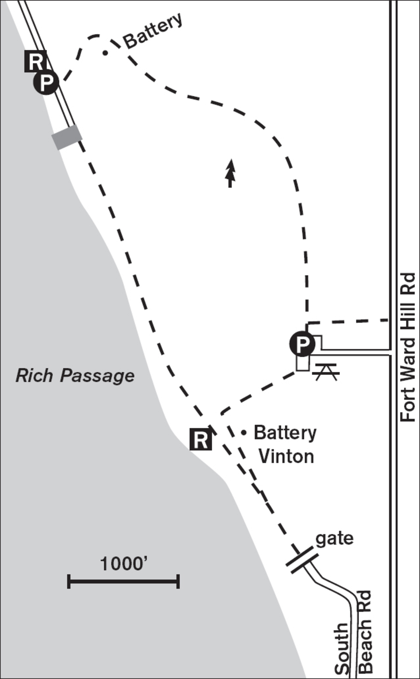
If you park at the boat launch at the northern end of the gated Pleasant Beach Drive, you can warm up with a stroll along the 4,300-foot paved trail bordering Rich Passage. To one side, sword ferns and horsetail vie for space beneath the hulking limbs of big-leaf maples and western red cedars. By the water, delicate white snowberries and wild roses line the path in late summer. Short spur trails lead to the water’s edge and blinds for observing herons, cormorants, loons, and maybe harbor seals.
At high or low tide, the best walking may be along the almost-mile-long beach, from which you can more easily smell the fresh salt air, watch ferries negotiate the narrow Rich Passage, and observe the antics of the double-crested cormorants as they stretch and preen on the offshore pilings.
At the southern end of the road, past the bird blind, you can ascend the steep paved trail to the upper picnic area. From here, if the ground is not too muddy, head down the 0.5-mile natural-surface trail back to the lower parking lot where you started. Along the way, you can search the forest trees for Steller’s jays and winter wrens. Don’t leave the trail, though; poison oak, an uncommon plant in the Northwest, lurks in the undergrowth—green in summer, red in fall.
ADDRESS: 2241 Pleasant Beach Drive NE, Bainbridge Island
GETTING THERE: From the Bainbridge ferry, head north out of Winslow on WA 305. Go 1 mile and turn left on High School Road. Follow the brown state park signs south. In summer, you can enter the upland picnic area (Fort Ward Hill Road) or the boat launch area (Pleasant Beach Drive). In winter, only the boat launch area is open for parking.
CONTACT: Bainbridge Island Metro Park and Recreation District, (206) 842-3343, www.biparks.org

34 SCHMITZ PRESERVE PARK
4 miles southwest of downtown Seattle
53 acres of old-growth forest reveal Seattle’s roots amid birdlife and a small stream.
| TRAIL | 1.7 miles; natural surface |
| STEEPNESS | Gentle |
| OTHER USES | Pedestrians only |
| DOGS | On leash |
| CONNECTING TRAILS | Alki Beach Trail |
| PARK AMENITIES | Parking lot, interpretive signs |
| DISABLED ACCESS | None |


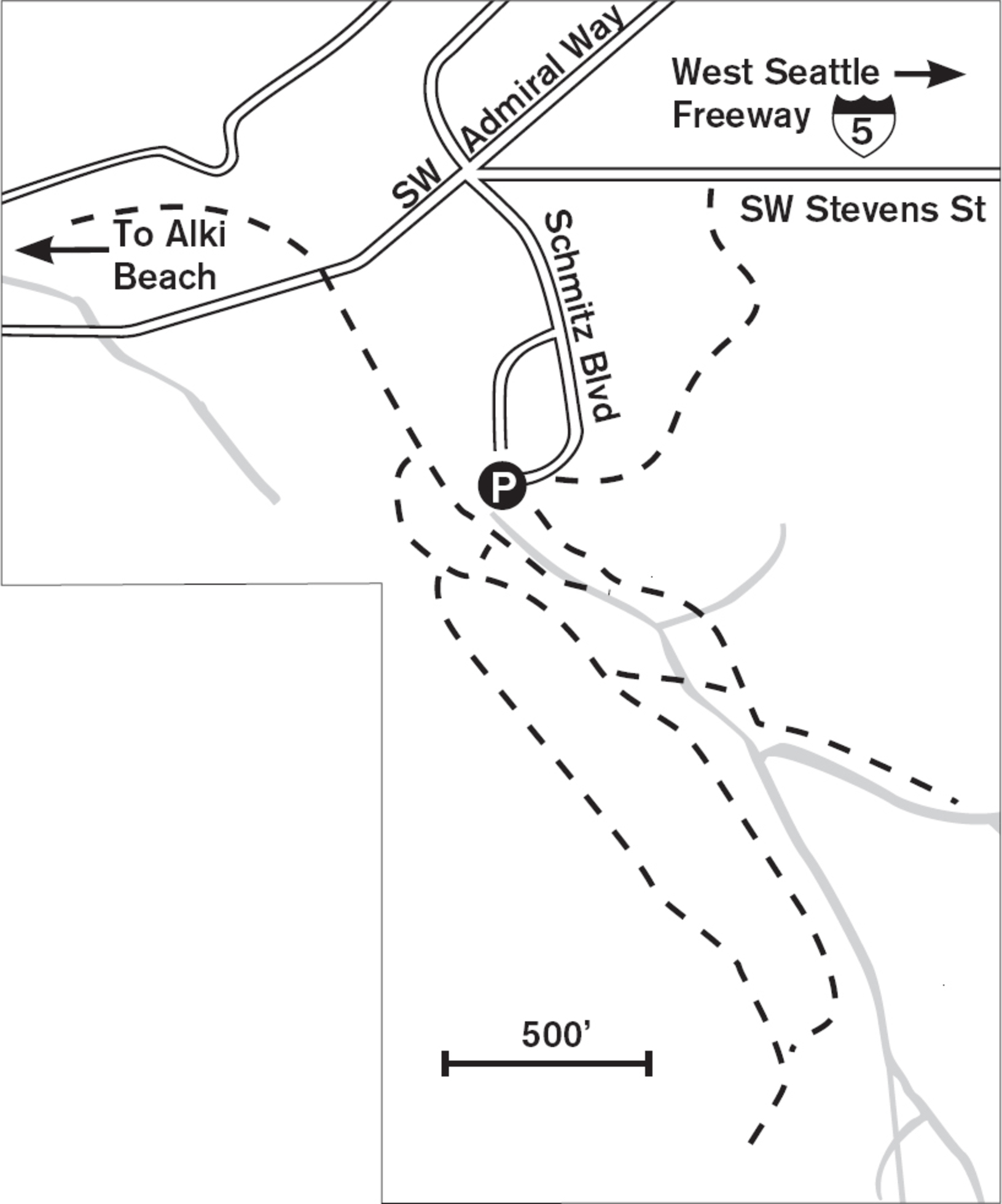
To stroll in Schmitz Preserve in West Seattle is to sense how the Puget Sound region looked before the arrival of the logging mills. Towering, massive western red cedar, western hemlock, and Douglas fir create an ancient ambience all around. Although it is not pristine—nonnative English ivy invades from the neighborhoods, and a few old stumps reveal the ravages of the logger’s saw—most of the forest remains untouched.
Walking the fir needle–lined path, you can hear birds singing, calling, moving about, and seeking food. Listen for the tapping of the pileated woodpecker, the largest North American woodpecker, with its bright-red crown, black-and-white neck, and black body. Nuthatches and brown creepers reside here, as does the less frequently seen or heard western screech owl.
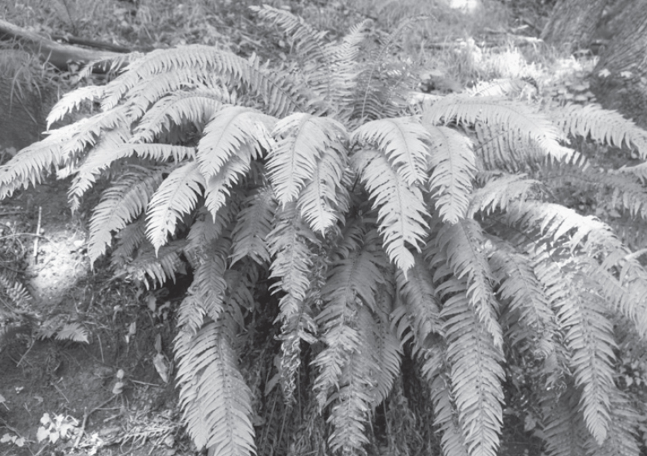

As you meander along a small stream, notice the amount and variety of life that comes from fallen trees. Saplings of alder, hemlock, and Douglas fir send fine roots into the decaying wood of ancient logs. Shrubs, too, such as red huckleberry and salal, find nutrients and moisture in these downed giants. Tall-standing snags house myriad insects that help supply the avian feeders. Removal of this downed wood and stumps would quickly destroy much of the life of the old forest, where the floor is often too thickly covered by needles and leaves to allow young saplings to grow.
For a more extended walk, stroll Schmitz Boulevard (closed to vehicles) north out of the parking lot. This old paved road leads through a deep ravine under Admiral Way, ending at a neighborhood park and playground.
ADDRESS: 5551 SW Admiral Way, Seattle
GETTING THERE: From I-5 southbound, take exit 163A (West Seattle Bridge/Columbian Way) and stay right. From I-5 northbound, take exit 163 (West Seattle Bridge/Columbian Way) and stay left to get on the West Seattle Bridge. Exit onto SW Admiral Way, following it uphill past a commercial district, then down a hill to SW Stevens Street. Look on the left for the park sign just before crossing a ravine. Turn left on SW Stevens Street, then bear right into the parking lot.
CONTACT: Seattle Parks and Recreation Department, (206) 684-4075, www.seattle.gov/parks. To volunteer, call (206) 684-8028 or e-mail parksvolunteer@seattle.gov.

35 CAMP LONG
5 miles southwest of downtown Seattle
Interpretive trails explore 68 acres of wild forest and ponds; a rock-climbing wall and high ropes invite challenge.
| TRAIL | 3.2 miles; natural surface, paved |
| STEEPNESS | Gentle to moderate |
| OTHER USES | Pedestrians only |
| DOGS | On leash |
| CONNECTING TRAILS | None |
| PARK AMENITIES | Restrooms, brochure, camping, classes, maps, picnic shelters, rock climbing, rustic cabins to rent |
| DISABLED ACCESS | Rolling Hills Trail, restrooms, cabins |


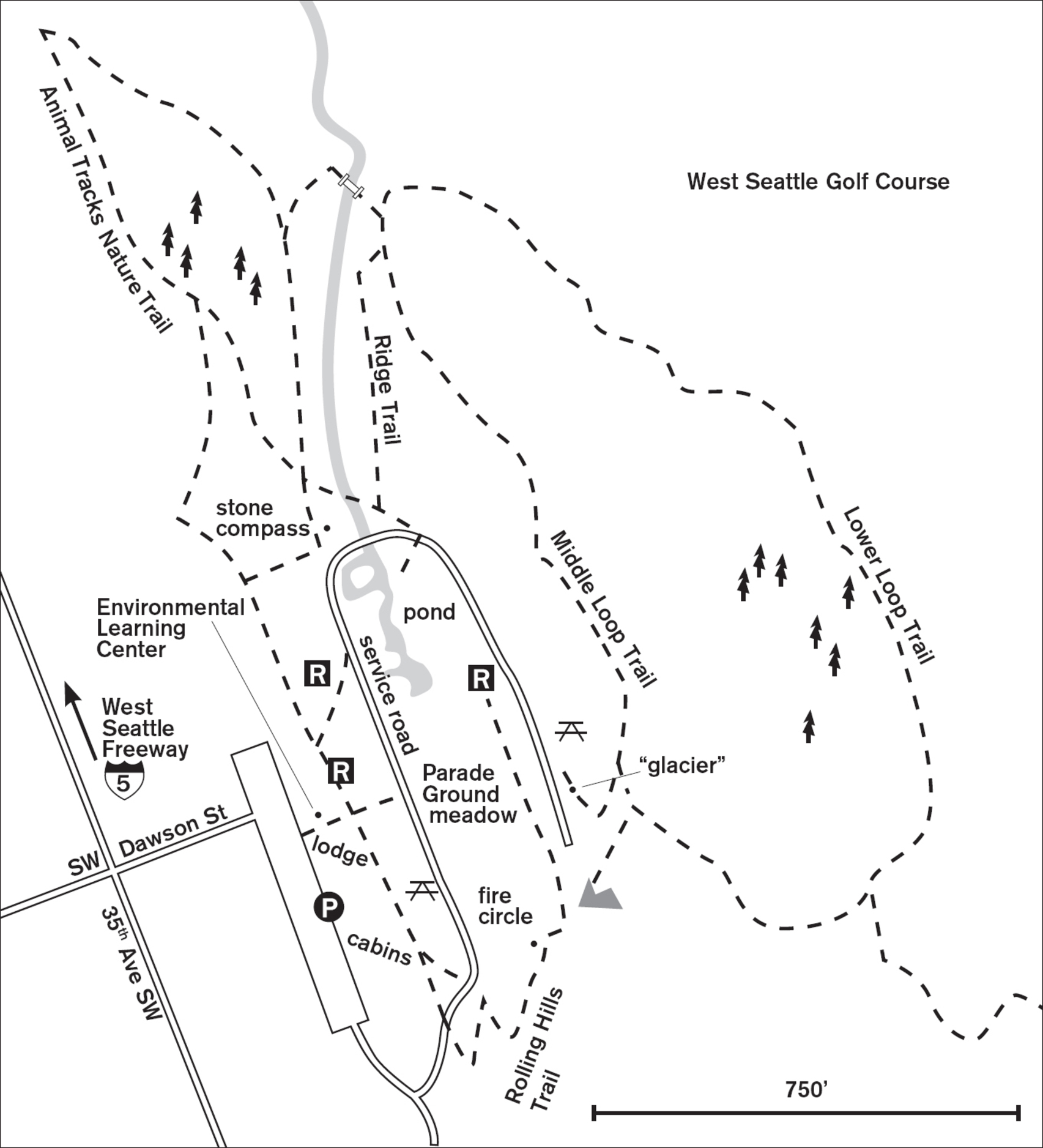
Walking in Camp Long is like finding wildlands in West Seattle. The air is fragrant with earth and greenery and sweet forest smells. Although this city park offers overnight camping (the only public camping in Seattle), these 68 acres hold more than cabins and a lodge. They are, for the day hiker, a place of tranquility and adventure. Beginning at the rustic 1940s lodge, walk left past the cabins to the beginning of the Animal Tracks Nature Trail. This 0.5-mile loop leads past ancient cedar stumps to a newer forest of alder and willow. Plaster casts of raccoon, heron, skunk, coyote, red fox, and squirrel tracks are displayed at the trailhead.
The longer Middle Loop Trail veers off from the nature walk, leading downhill through second-growth forest to the boundary near the golf course. This is a wet trail in winter, but board walkways provide some relief from the mud. Due east of the lodge, you come to Polliwog Pond, where turtles bask, salamanders slither, and water insects hatch. If you’re lucky, you may see hawks, owls, or great blue herons.
The park offers classes on wetlands ecology, forest and pond ecology, and forest dwellers. Special park features include a high ropes challenge course, a climbing rock (on which instruction is given by prearrangement), and the “glacier,” a concrete and stone structure with handholds and toeholds for climbing and rappelling.
ADDRESS: 5200 35th Avenue SW, Seattle
GETTING THERE: From I-5 southbound, take exit 163A (West Seattle Bridge) and stay right. From I-5 northbound, take exit 163 (West Seattle Bridge), and stay left to get on the West Seattle Bridge. Follow it to its end, staying left. At the first light off the freeway, turn left onto 35th Avenue SW. Go 1 mile and turn left on SW Dawson Street to enter the park. Closed Mondays and holidays year-round, as well as Sundays in January.
CONTACT: Seattle Parks an Recreation Department, (206) 684-7434, www.seattle.gov/parks. To volunteer, call (206) 684-8028 or e-mail parksvolunteer@seattle.gov.

36 LINCOLN PARK
8 miles southwest of downtown Seattle
Bluffs and beaches along Puget Sound offer views of the Olympic Mountains from this 135-acre park.
| TRAIL | 5.3 miles, including 1 mile on a beach; gravel, paved |
| STEEPNESS | Level to steep |
| OTHER USES | Bicycles |
| DOGS | On leash |
| CONNECTING TRAILS | None |
| PARK AMENITIES | Restrooms, picnic shelters, playgrounds, sports fields, wading pool, swimming pool (summer only) |
| DISABLED ACCESS | Paved beach walk, restrooms, picnic areas |


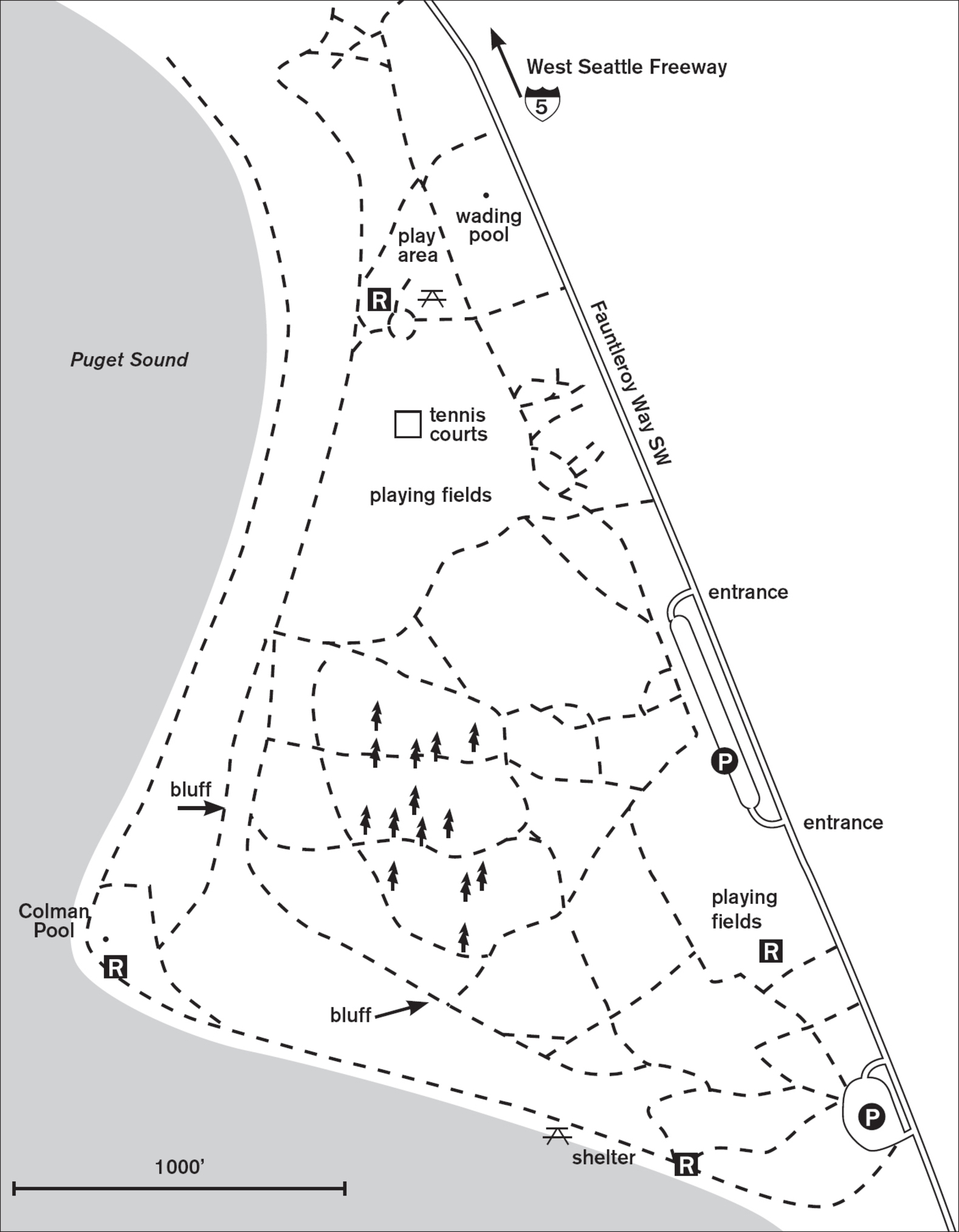
From high on the bluff at Lincoln Park in West Seattle, the barges and ferries look like large bathtub toys on the smooth water below. Madrona trees arch their vibrant red-barked limbs over the trail, and offshore an eagle may glide. These 135 acres of parkland offer lawns, views, beach, and water’s-edge walking.
From the parking lots along Fauntleroy Way SW, choose any of the wide, smooth, and graveled paths, and walk west to wander between large old western hemlock and Douglas fir trees. Open lawns and picnic shelters with playgrounds attract many of the park’s users, but for a walk, continue west to the bluff. Sloping gently to the south, the paved trail gives views out onto Puget Sound and Vashon Island. Curve around and down to the shore, where fresh breezes from the south stir the water and create waves that clatter the pebbles on the beach.
Wide, paved, and level, the mile of beach walk invites either a slow stroll or a heart-pumping power walk. Winter storms bring waves that crash against the seawall and throw mighty drift logs high on the beach. In milder weather, the shoreline begs for exploration. At the northern end, past the swimming pool, the walkway narrows to a seawall under the branches of a slope of mixed conifers, maples, and red alder. Choose a nonthreatening path up (one that slopes rather than climbs) to return to the upper park.
ADDRESS: 8011 Fauntleroy Way SW, Seattle
GETTING THERE: From I-5 southbound, take exit 163A (West Seattle Bridge/Columbian Way) and stay right. From I-5 northbound, take exit 163 (West Seattle Bridge/Columbian Way), and stay left to get on the West Seattle Bridge. Follow it to its end, and continue straight as it becomes Fauntleroy Way SW and curves left. In about 2 miles, the park is on the right.
CONTACT: Seattle Parks and Recreation Department, (206) 684-4075, www.seattle.gov/parks. To volunteer, call (206) 684-8028 or e-mail parksvolunteer@seattle.gov.

37 WESTCREST PARK
7 miles south of downtown Seattle
Enjoy mountain and city views, then walk 80 acres of sylvan trails in Seattle’s largest forest.
| TRAIL | 4.4 miles; natural surface, paved |
| STEEPNESS | Level to moderate |
| OTHER USES | Bicycles |
| DOGS | Off-leash area, otherwise on leash |
| CONNECTING TRAILS | Duwamish Watershed Trail |
| PARK AMENITIES | Restrooms, picnic tables, playground, art, community garden |
| DISABLED ACCESS | Paved trail |


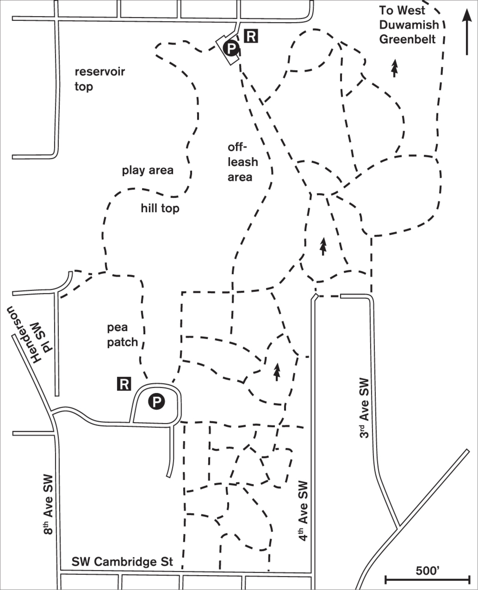
Laid out like a green carpet atop south Seattle, Westcrest Park entices with acres of green lawn, paved trail, and wonderfully innovative playgrounds. But step off the hilltop into the sloping forest of the Duwamish Watershed to the east, and you enter a sylvan land of manicured trails under a canopy of hemlock, fir, and big-leaf maples.
The original Westcrest Park was wrapped squarely along three sides of the West Seattle Reservoir, but in 2011 the reservoir was lidded, and later these 20 acres were included in the park. Artful renovation and construction, completed in 2015, has turned a reservoir lid into beautiful lawn and paved walkways. The play area is particularly interesting, with a modified zip line and an innovative set of slides to help the smallest walkers descend from the upper lawns to the lower paths. Of aesthetic interest are the airplane-like kinetic sculptures by David Boyer, called Flyers. On a clear day you get great views of the Olympics to the west and the Cascades to the east.
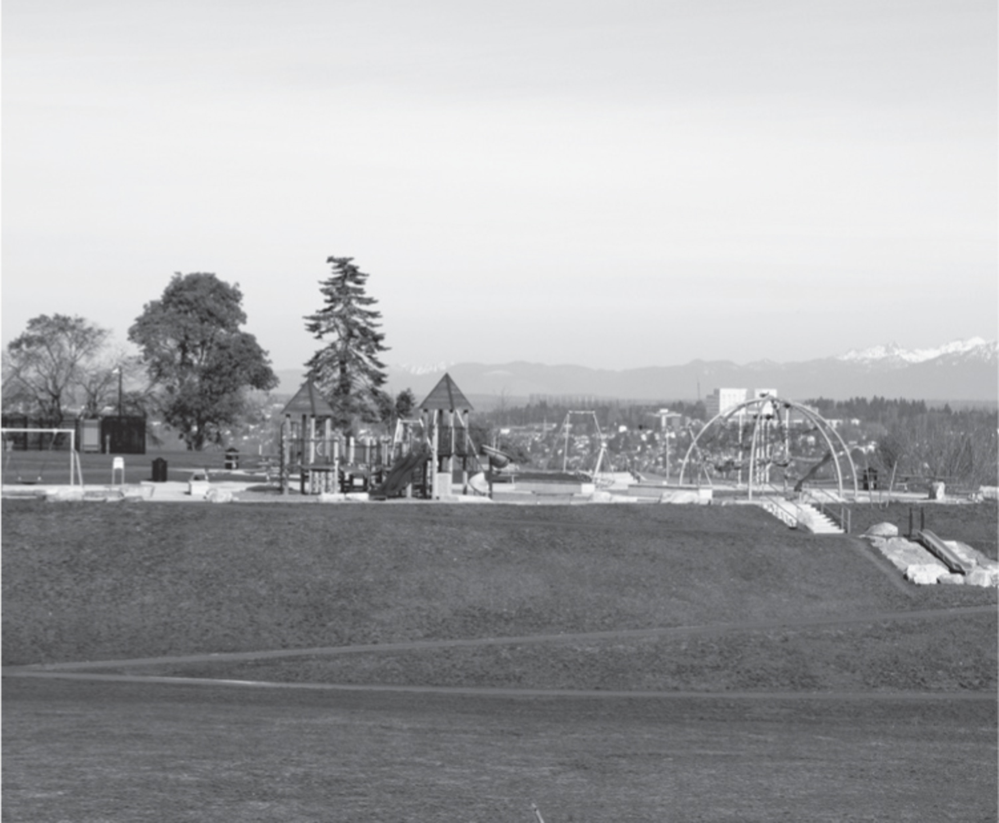

The large dog park attracts the majority of walkers, as there are acres of land for the pups to roam, including a separate small and shy dog enclosure. Once they’ve run their fill, put the dogs back on leash and enjoy the shaded trails to the east that crisscross through Seattle’s largest standing forest, the Duwamish Watershed. Well-maintained trails lead through high-canopy evergreen forest, and trail signs help keep you oriented.
ADDRESS: South parking lot: SW Henderson Street, Seattle; Park location: 9000 8th Avenue SW, Seattle
GETTING THERE: From WA 99 southbound, merge right onto WA 509. Continue 1.2 miles and take the Myers Way/White Center exit. Stay right to merge onto Olson Way SW. In 0.4 miles turn right onto SW Roxbury Street. Turn right onto 8th Avenue SW. In 0.2 miles turn right onto SW Henderson Street into the park.
From I-5 northbound, take exit 154 (WA 518/Burien) and head west on WA 518. Go 3.2 miles and exit onto WA 509 toward Seattle. In 1.2 miles turn left onto S 128th Street. Go 0.6 miles and turn right onto 4th Avenue SW. Continue 2 miles and turn left onto SW Roxbury Street and proceed as above.
CONTACT: Seattle Parks and Recreation Department, (206) 684-4075, www.seattle.gov/parks. Volunteering is welcome.

38 LUTHER BURBANK PARK (MERCER ISLAND)
Mercer Island, 6 miles southeast of Seattle
A historical setting with 77 acres on Lake Washington offers wetlands, meadows, and unusual art.
| TRAIL | 3 miles; natural surface, paved |
| STEEPNESS | Level to gentle; some steps to lake |
| OTHER USES | Bicycles |
| DOGS | Off-leash area, otherwise on leash |
| CONNECTING TRAILS | None |
| PARK AMENITIES | Restrooms, picnic areas, boat docks, playground, swimming beach, tennis courts, art |
| DISABLED ACCESS | Paved trails, restrooms, picnic areas |


You can almost imagine the vast hand of the Lake Washington spirit reaching over this northeastern corner of Mercer Island and holding back the surrounding suburbia to preserve this stretch of land. With its grassy meadows, neatly tended lawns, pockets of berries, and bogs, Luther Burbank Park offers breathing space and expansive views across the lake to Bellevue and Seattle.
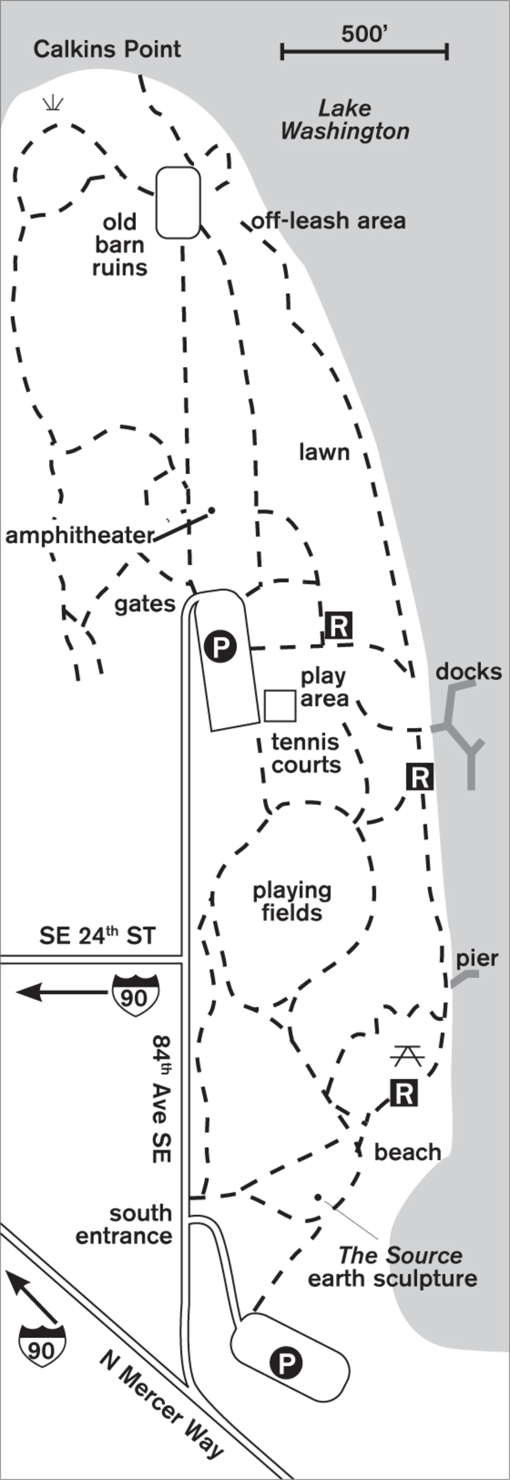
Once the grounds of a home for wayward Seattle boys, these 77 acres retain a few reminders of days past. Two sturdy brick buildings are all that remain intact of the Boys Parental School (later renamed Luther Burbank School). When you walk north from the building past the elegant poplar and cottonwood trees, stop and explore the ruins of the old barn. For more than 50 years, Holstein cows grazed where boat watchers sit today on the gentle hills of Luther Burbank Park.
At Calkins Point on the northern tip, a marshland harbors frogs and ducks as well as red-winged blackbirds. Bear right and walk south along the waterfront, past the buildings to the docks, tennis courts, and picnic areas. If you’ve come with kids, plan on a long pause at the playground. This one was created by someone with a fertile imagination: brick hills to climb, endless slides, and swings—all cushioned with tire chips for safe landings.
When you can lure the kids off the brick mountains, head south across the meadow to explore the earth sculpture with its furrows and hills. What a great landscape for make-believe forts or wild games of tag. In summer, the grassy bumps and the nearby beach ring out with the calls of children. Complete the loop with a stroll north again along the water’s edge, past secret hideouts for the lake’s feathered inhabitants, ending at the docks.
ADDRESS: 2040 84th Avenue SE, Mercer Island
GETTING THERE: From I-90 eastbound, take exit 7A (77th Avenue SE). Turn left at the stop sign, go across the freeway, then turn right onto N Mercer Way. Go 0.2 miles and turn left onto 81st Avenue SE. Go to the stop sign and turn right on SE 24th Street. When the road curves right, go left onto 84th Avenue SE into the park.
From I-90 westbound, take exit 7 (Island Crest Way). At the top of the ramp, turn right onto SE 26th Street. In 0.1 miles turn left on 84th Avenue SE to enter the park. The park is open from 6:00 a.m. until 10:00 p.m. daily.
CONTACT: Mercer Island Parks and Recreation Department, (206) 275-7609, www.mercergov.org. To volunteer, call the volunteer coordinator at (206) 275-7841.

39 PIONEER PARK
Mercer Island, 8 miles southeast of Seattle
Explore 113 acres of forest on a labyrinth of trails in the island’s center.
| TRAIL | 5 miles total; natural surface, paved |
| STEEPNESS | Gentle to moderate |
| OTHER USES | Bicycles; horses in southeast section and on Fire Station Trail in northwest section |
| DOGS | On leash |
| CONNECTING TRAILS | None |
| PARK AMENITIES | None; guidebook available at Mercer Island Parks office |
| DISABLED ACCESS | Much of perimeter trail of northwest section |


Wander a labyrinth of trails through second-growth forest in this touch of wildness in the center of Mercer Island. Raccoons leave footprints on the dirt trails, and squirrels chatter from the branches.
Logged about 75 years ago, the forest now supports a variety of trees, including alder, maple, madrona, western hemlock, and Douglas fir. Many have English ivy (an unwanted volunteer from nearby homes) clinging to their trunks like shaggy blankets or display a fine coating of blue-green lichen on their northern sides.
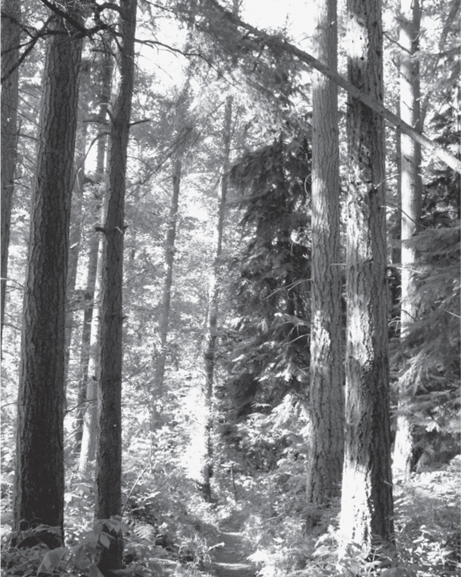

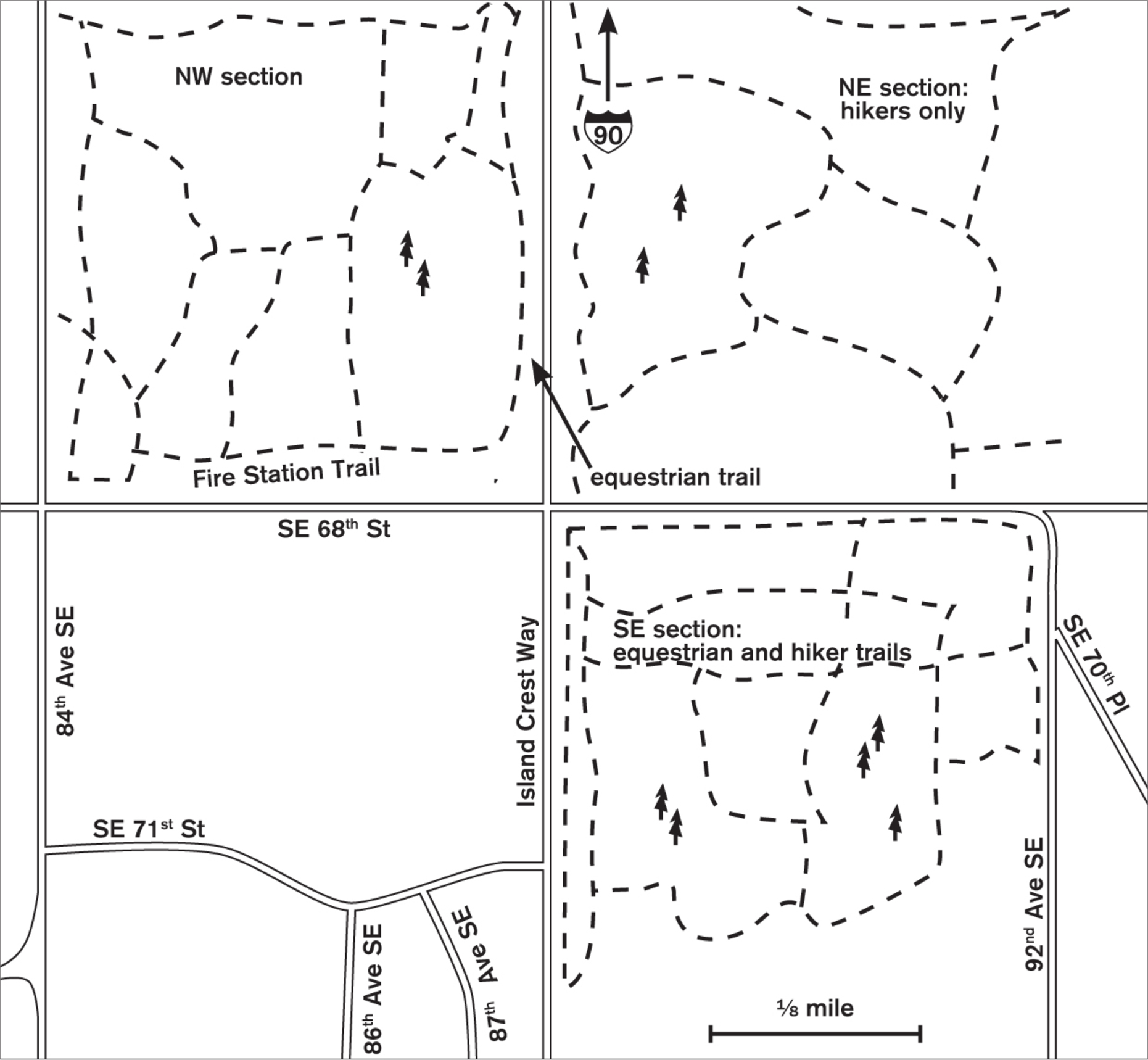
Park on Island Crest Way near SE 68th Street and dive in. Trails meander through each of the three sections of the park, which intersect at SE 68th Street and Island Crest Way. You can choose the company of horses (in the northwest and southeast sections) or not and choose level (northeast section) or sloping (southeast section) land. With many kid-created side trails, you could possibly get lost, or at least end up in someone’s backyard. To maintain your bearings, listen for the traffic on Island Crest Way, and in the southeast section remember that uphill leads to the west and Island Crest Way.
Try a winter walk here, when the cold has hardened the dirt trails. With the leaves gone, you can look out through the sinewy forms of naked branches to Lake Washington. Oregon grape, sword ferns, cedars, and hemlocks all shimmer in vibrant green against the browns and grays of winter bark.
ADDRESS: SE 68th Street and Island Crest Way, Mercer Island
GETTING THERE: From I-90 eastbound, take exit 7B (Island Crest Way). The ramp leads directly onto Island Crest Way southbound. Go about 3 miles, and park at the ball fields on the west side of Island Crest Way at about SE 63rd Street. Limited on-road parking only.
From I-90 westbound, take exit 7 (Island Crest Way). Turn left at the top of the ramp and cross the freeway. Go straight onto Island Crest Way southbound, and proceed as above.
CONTACT: Mercer Island Parks and Recreation Department, (206) 275-7609, www.mercergov.org. To volunteer, call the volunteer coordinator at (206) 275-7841.

40 SEWARD PARK
6 miles southeast of downtown Seattle
Old-growth forest abounding with birds and beaches along Lake Washington’s shoreline offers views of the Cascades from this 299-acre park.
| TRAIL | 5.7 miles; natural surface, paved |
| STEEPNESS | Level to gentle |
| OTHER USES | Bicycles on paved loop only |
| DOGS | On leash |
| CONNECTING TRAILS | Lake Washington Boulevard |
| PARK AMENITIES | Restrooms, amphitheater, art studio, playground, fishing pier, interpretive center, picnic shelters |
| DISABLED ACCESS | Paved trail, restrooms, picnic shelters |


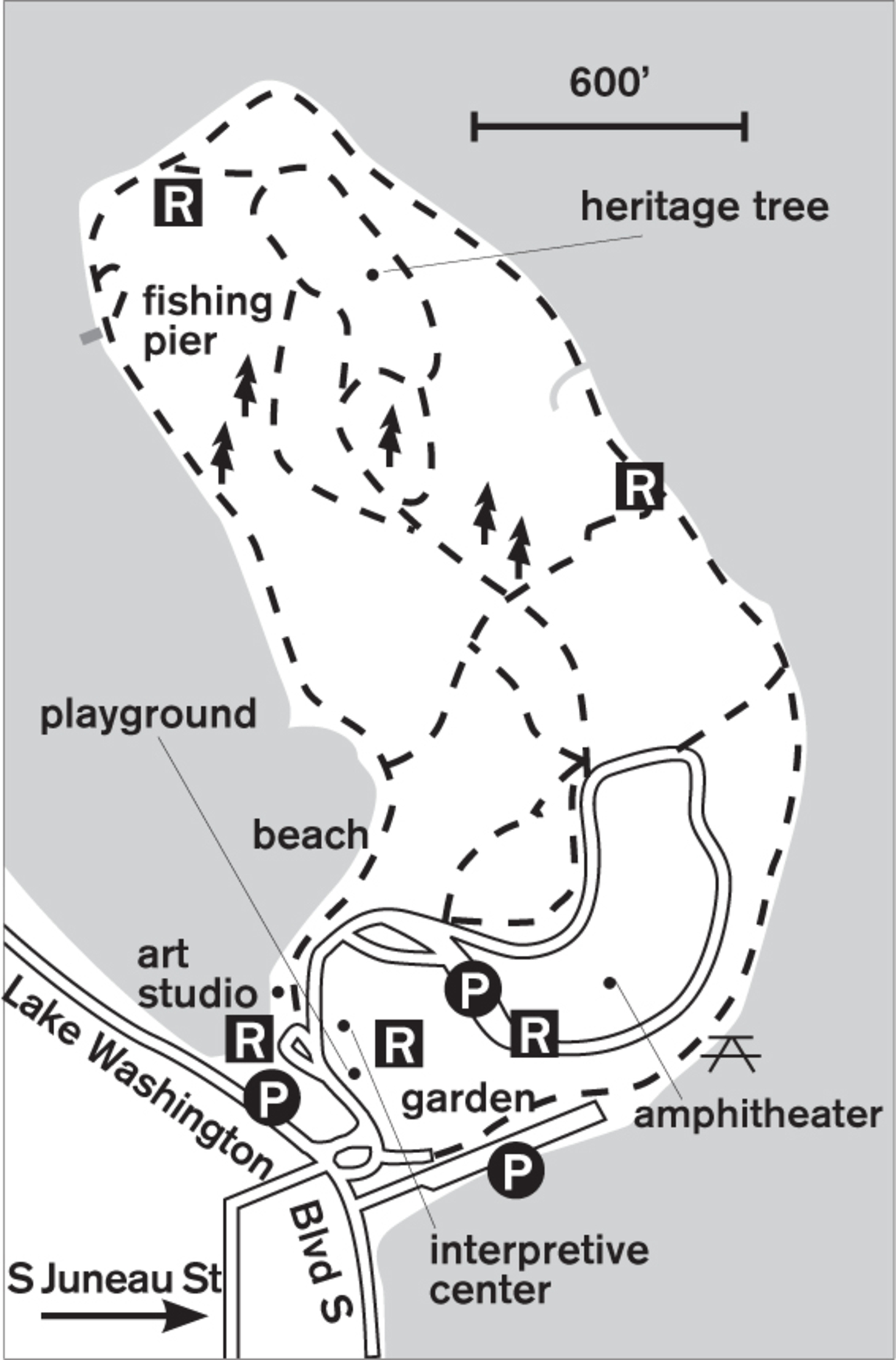
Seattle’s largest tract of old-growth forest crowns thumb-shaped Bailey Peninsula, jutting into Lake Washington. Acquired by the city in 1911 as an island, Seward Park was transformed into a peninsula when the lake receded as a result of the building of the ship canal in 1916.
Deep in this forest of immense precolonial western red cedar, western hemlock, and Douglas fir, varied thrushes call in winter, and in spring the forest comes alive with mating songs and calls of the migrant warblers and kinglets. No city sounds impinge on this woodland with its varied undergrowth of sword fern, Oregon grape, thimbleberry, salal, and twinberry. The main trail follows the spine of the gentle ridge, with numerous side trails leading out of the forest to the lakeshore loop walk.
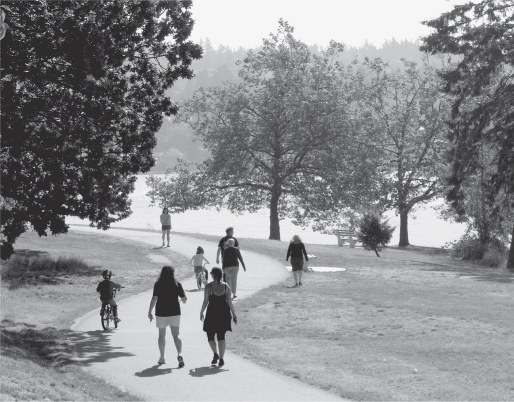
The forest trail and the shore are so different that it’s hard to believe they’re part of the same park. From the quiet tranquility of the old forest, you emerge to a faster-moving world. On the paved 2.6-mile shore loop, bicycles zoom by, and the in-line skaters skate-dance to music from their headphones. But with grassy stretches on either side of the trail, there is plenty of room for everyone. In summer the beaches ring with the calls of children, and colorful kayaks can be seen on the calm water.

In fall, the southern part of the shore trail is lined in orange and red feathery sumac, salal, and hedges of snowberries, and the maples flash warm orange and yellow colors against the blue of the lake. Poison oak lurks among the shrubbery; look for its distinctive leaves in sets of three, shiny green in summer and turning red in fall. Tall madrona trees with their beautiful peeling bark accent the trail edges. Standing on the lakeshore in winter, you may see a variety of wintering waterfowl such as mergansers, grebes, and wigeons.
ADDRESS: 5900 Lake Washington Boulevard S, Seattle
GETTING THERE: From I-5 southbound, take exit 163A (Columbian Way) and stay left to cross the freeway onto Columbian Way. If northbound, take exit 163 and stay right to get on Columbian Way. Go southeast 1.4 miles and turn right on Beacon Avenue S. Go about 0.5 miles and turn left on S Orcas Street. Head east and at the T-junction at Lake Washington Boulevard S, turn right, then immediately left into the park.
CONTACT: Seattle Parks and Recreation Department, (206) 684-4396, www.seattle.gov/parks. For information on volunteering, visit the Friends of Seward Park website: www.sewardpark.org.

41 KUBOTA GARDEN
7 miles southeast of downtown Seattle
This 34-acre Japanese garden features a stream, ponds, native and ornamental plants, and art.
| TRAIL | 1.5 miles total; gravel, natural surface |
| STEEPNESS | Level to steep |
| OTHER USES | Pedestrians only |
| DOGS | Not allowed |
| CONNECTING TRAILS | None |
| PARK AMENITIES | Restrooms, gardens, benches, free guided tours on weekends (except in winter), map, picnic tables |
| DISABLED ACCESS | Some paths |


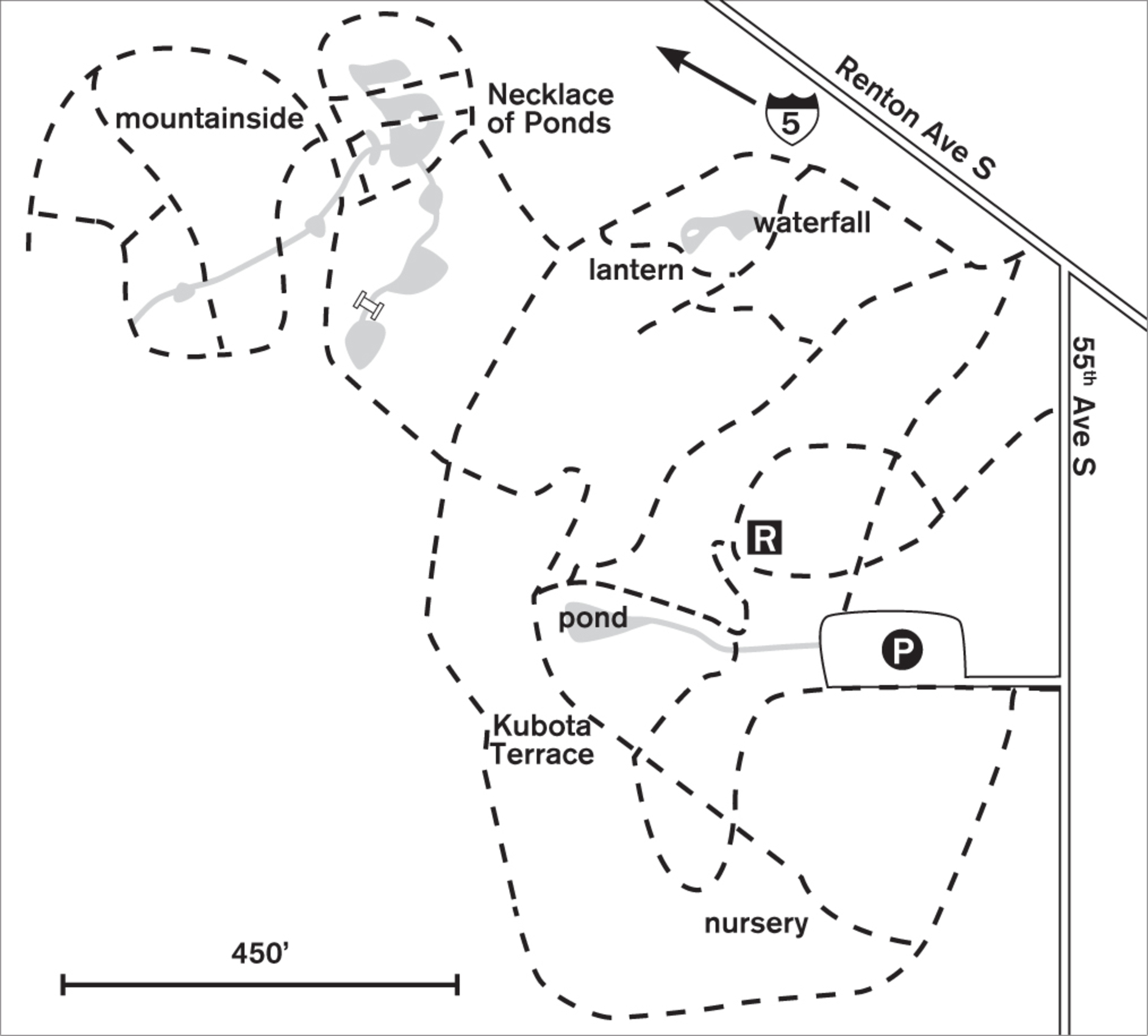
This public garden, featuring exotic plants, walkways wide and narrow, waterfalls, and ponds is a place for meditation and quiet strolls. Pleasure comes not only from the visual but from the almost tactile sense of shape and design.
Originally a nursery of 20 acres surrounding an ambitious system of streams and waterfalls, and later passed on to Seattle by the Kubota family, the garden continues to provide a place of beauty through form and color, texture and fragrance. Labeling plants was not a priority of the Kubotas, nor is it now. Mature rhododendrons—some 15 feet high and of unknown lineage—bloom in spring, livening the garden with robust color. Migrating songbirds find refuge here, filling the air with their calls. Japanese red and black pines and both yellow and black bamboo grace the paths.
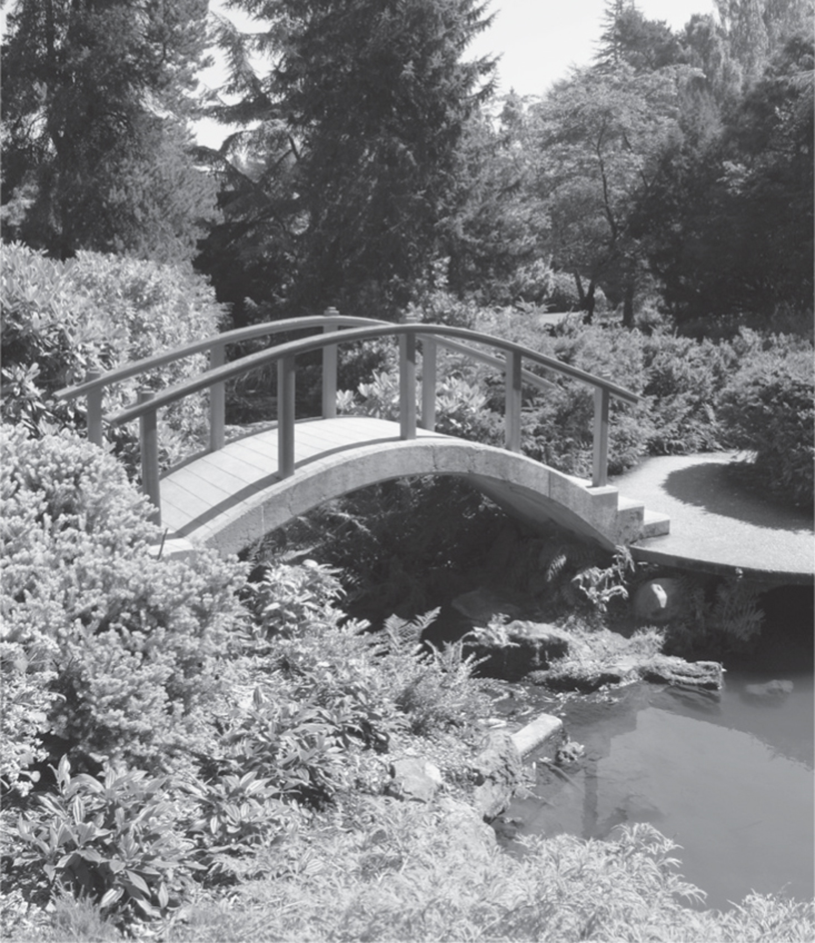

This is a garden for meandering, for viewing from all directions. You may have passed the arched Moon Bridge before, but now you tilt your head another way, the sun has dropped lower, and the garden reveals yet another aspect of color, texture, or shape. Climb the “Mountainside” to enjoy territorial views and perhaps to watch the golden carp in the Necklace of Ponds, 65 feet below. Experience the garden in all seasons and watch the colors and textures change.
ADDRESS: 9817 55th Avenue S, Seattle
GETTING THERE: From I-5 southbound, take exit 158 (Boeing Access Road). Turn left to cross the freeway and head straight up S Ryan Way. At the T-junction, turn left on 51st Avenue S. Turn right on Renton Avenue S, then right on 55th Avenue S. The parking entrance is on the right.
From I-5 northbound, take exit 157 (Martin Luther King Jr. Way). Follow Martin Luther King Jr. Way to S Ryan Way, turn right, and proceed as above.
CONTACT: Kubota Garden Foundation, (206) 725-5060, www.kubotagarden.org; Seattle Parks and Recreation Department, (206) 684-4584, www.seattle.gov/parks. Volunteering is welcome.
