
6
ALASKA PANHANDLE
 Prince Rupert to Juneau 382/1,150 miles
The frontiers are not East or West,
North or South,
but wherever a man fronts a fact.
—HENRY DAVID THOREAU
The last frontier. Alaska hangs off the shoulder of the North American continent like the proverbial carrot and stick, and attracts a diverse assortment of characters with peculiar predilections. Dreamers, cranks, end-of-the-roaders, all manner of people make their way north or, having had the blessing of Alaskan birth, remain. Many are back-to-the-landers: wannabe trappers, homesteaders, or pot farmers; some are angst-ridden greens. A few are fed-up militia misfits, Libertarian idealists, or just run-of-the-mill misanthropes; most are insufferably self-reliant—and competent—egoists. Soldiers, petty bureaucrats, and resource extractors, drawn by big bucks to endure two-year stints in the bush, commit, endure, and often burn out. All have found a welcome niche in Alaska. That is, for as long as they can abide the dark, the damp, and the cold. Not a few are socially inept, given to non sequiturs and conversational spurts and lapses reminiscent of communication on time-delayed satellite radios, complete with bad reception. Most are vulnerable sorts, often overly friendly, open, and honest, yet suspicious and quick to anger. All are eccentric to a fault. It is truly a quaff of fine ale. To a special sort of woman, these are MEN, real men.
Chuck La Queue (his real alias) is a real man. Tall, hirsute—handsome, in spite of his thick Barry Goldwater glasses—and slightly lordotic, Chuck drove his VW microbus to Alaska to prospect a job with the newly approved Trans-Alaska Pipeline project in 1973. Accosted at the border by overly enthusiastic INS agents, he fought back with a full, double-barreled arsenal of a cappella Irish rebel songs at high volume and in a full-throated, resonant baritone. Chuck is a world-class kayaker. He was fresh off a first descent of the headwaters of the Amazon and needed a change. Unable to sign on with the Alyeska consortium immediately, he joined the commercial crab fishing fleet for a stint in the frigid waters of the Gulf of Alaska. He survived one season. Chuck wasn’t—and isn’t—a team player. Once, when planning a kayak expedition and short on funds, he tried a new approach to victualing. He’d heard that strapped inner-city senior citizens in New York City were resorting to subsisting on pet food for its value-to-volume efficiency, so he packed a month’s supply of Gaines-Burgers. When they turned out to taste like lard-laced sawdust with just a hint of offal, he tried cooking them. Though they were still inedible, he nonetheless ate them. To his grumbling teammate, a redhead with a limp whom he’d enlisted during a night of excess at the Red Dog Saloon in Fairbanks, he declared, like a disgruntled prospector (a profession he pursues intermittently), that if she didn’t like the way things had turned out, he’d “buy her out!”

Chuck is particular. Once, passing the time at a local watering hole, he befriended an attractive off-duty Tongass National Forest rangerette from the Ketchikan District. Passing time soon became making time. Since he’d been considering an Inside Passage paddle, he asked her in what direction the predominant winds blew. She responded that she hadn’t noticed. All of a sudden, Chuck visibly lost interest and left. Puzzled—they’d already locked eyeballs and were sniffing each other like dogs—I asked why he walked away from a sure prospect. “She’s unobservant,” he tersely declared with not a little contempt for her, her competence, the Forest Service, the question, and even me—for prying. Today, Chuck splits his time between working winters for the pipeline in Prudhoe Bay and doing construction in summertime Phoenix, Arizona. To do otherwise, he quietly avers, would be un-Alaskan.
Markle, another real man, is Chuck’s neighbor. In Detroit, before he moved to Alaska, he sold used cars. He lives in a mini-Quonset hut, uninsulated except for the stacks of books, clothes, and outdoor gear along the outside walls. An oversize wood-burning stove dominates the Quonset. Unlike Chuck, Markle has running water, phone, and electricity from a utility. Now he lives his passions: kayaking and mountaineering, at both of which he’s notably accomplished. When the outdoor season dawns, an intricate—and predictable—minuet ensues. Markle requests a sabbatical from his job. Invariably, he’s turned down. So he quits and goes off chasing what’s important to him. Upon his return, his old boss invariably rehires him. Seems his skills are indispensable. To supplement his income he sequesters himself with a phone for extended commodities-futures trading sessions. Markle, like Chuck, is unmarried and lives alone. Alaska has a disproportionate number of real men, or, as they say up there, “The odds are good, but the goods are odd.” And they attract a particular sort of woman.
We met Kristin on the water. She was kayaking to Alaska to find a real man. At 24, she was becomingly steatopygous with a strong upper torso to match. Barefoot, unkempt, and underdressed, with a shotgun slung from her shoulder, few men could resist her. Her eyes were pools of mystery; she was quiet and verbally shy. Pouty, everted lips shielded oversized and bunny-toothed incisors that hinted of prognathy. She had a perfectly rounded, dolichocephalic skull with a high forehead. A hint of lanugo caressed her cheeks. She was quite compelling in an untraditional sense. An assayer by trade, Kristin hailed from Dawson, Yukon Territory, and was traveling light—no stove, a simple tarp, no brand-name gear. She was obsessively focused on her quest, and no single man got away from her. She was literally testing every available male on her route, fishermen first. When we last heard of her—she was a minor legend by then—she’d taken up with a part-time fisherman and log salvager living at the edge of a small waterfront community.
Log salvaging, or beach logging, like gathering aluminum cans along rights-of-way in the Lower 48, is a handy source of pocket money and a not uncommon sight along the Inside Passage. The log salvager, one man working with a small skiff or inboard, often with his son, will scour sounds, inlets, passages, and beaches for escaped logs on the lam. On a bad day, suitable driftwood will suffice. Spotting a likely mark, the salvager will typically nose the boat up to the beach, jump out with a choke cable while the boat idles, hawse it around the log, jump back in, and hope his engine and skill can refloat it for a bounty. A sawmill will pay, depending on the species, upwards of $500 for a 50-foot-long, 18-inch-diameter log. The same size log, prime construction-grade Douglas fir, dressed—with little or no taper—might retail for $1,500.

The welcome sign in the park next to the chamber of commerce in Port Hardy encapsulates a particular view of the Northwest Coast: PORT HARDY: LOGGING, FISHING & MINING. The sign is incomplete; “Tourism” is missing. These pursuits are as intricately intertwined with the Northwest Coast as Guinness, sheep, and music are with Ireland. All four are pursued at industrial proportions; as family enterprises; and as individual efforts that supplement fluctuating and seasonal incomes.
Perhaps Alaska attracts its fair share of eccentric opportunists because, perceiving itself a tough sell, it has resorted to offering particularly attractive packages—thong-clad, some might say—of its resources. Allotted on an individual basis, some of these packages are outright giveaways. The 1862 Homestead Act, repealed in 1976, was resuscitated in Alaska in 1984 for an encore. Before the state act was terminated in 1991, 1,600 Alaskans were awarded homestead permits. It was still a tough sell. Only 12 percent proved up their land. In step with the generous land allotments, logging, fishing, mining, and tourism followed suit. During the early years, individuals could appropriate up to 25,000 board feet of lumber and 25 cords of wood from the Tongass National Forest. Trap fishing, outlawed virtually everywhere along the Inside Passage at a very early date, was outlawed in Alaska only at the time of statehood, in 1959. The controversial—and still extant—Mining Act of 1872 allows mineral claims on public land without payment of royalties and with allowances for patenting. The most innovative mineral giveaway has to be the Alaska Permanent Fund, established in 1976. Funded by oil revenues, the fund pays a dividend to every resident who has lived in Alaska for at least six months. The 2017 check totaled $1,110. For a time, the US Forest Service (USFS) allowed special use permits for recreational cabins in the Tongass. Today, the Forest Service maintains recreational cabins for public use at a nominal fee.
Logging
Along the Inside Passage, the trees are tightly spaced, the branches almost touch, and undergrowth clogs the understory, but the timber industry is as ever present as rain. Clear-cuts, abandoned roads to nowhere, booming grounds, tug-towed booms, pulp mills, solitary log salvagers, deadheads, helicopter skidders, log freighters, and lumber barges are each a visible component of an intricate and complex operation that we tried to accurately fit and sequence—like a puzzle—and then comprehend to keep our minds entertained while paddling. From the water, the forest seems impenetrable.
One day, in Sunderland Channel, the lateness of the hour and absence of beaches forced us to broach the forest battlements, enter and—improbably but desperately—look for a clear, flat spot. We were stunned. Inside, the forest opened up somewhat and little undergrowth grew. But the slash piles, oil spills, and garbage—the stink and detritus of loggers long (and not so long) past, dominated the scene and shocked us. Trained as an archaeologist, I must have been the only one of our group that found anything redeeming in the tableau. I looked for some diagnostic sign that might date the depredation. It was right there in front of us, invisible—a case of being unable to see the trees for the forest: giant stumps like spectral headstones commemorating a vanished world, 5 to 8 feet high and 6 to 8 feet in diameter; pockmarked with two to four incongruous ax-hewn niches always 2 or 3 feet below the flat top; and widely spaced among the spindly second- and third-growth saplings that had regenerated a mere 3 to 10 feet apart. So widely spaced were the big fellows that the scale of that extinct and unimaginable prehistoric forest must have been Brobdingnagian. We wanted to see—what in our mind’s eye we pictured as a Tolkien-like copse—such a forest.
A surprising number of locales along the Inside Passage, even in Puget Sound, are touted as being “old-growth,” or, as is now more common, first-growth. In a nutshell, old-growth forest is one that has never been logged. So we made a point of seeking out vestigial old-growth sanctuaries such as the Brothers Islands, just south of Admiralty Island. We were underwhelmed. True, there was gardenlike undergrowth—gorgeous moss and ferns—no stumps, and no sign of man. These islands had never been logged. But the trees were a humdrum 1 to 2 feet in diameter. We’d been expecting to see the old giants. We felt cheated.
The definition of old-growth can be a bit slippery. Up to 15 to 20 percent of a stand can be logged and still be considered old-growth; an entire forest can be clear-cut and also be considered old-growth if the event occurred more than 125 years ago. And tree size is not a factor. Local microclimatic conditions determine whether a particular stand of trees achieves its full genetic potential or not. And potential they do have. The largest trees were the Douglas fir, the Sitka spruce, and the western red cedar. Botanists theorize that the tendency toward gigantism is a function of millennia of genetic evolution uninterrupted by the glacial episodes of past ice ages. The Inside Passage was generally ice-free when much of the rest of North America was covered with ice. Certain arboreal genetic lineages advanced and retreated in step with the glacial advances along the ice-free corridor, adapting and surviving. What to our imagination are true old-growth forests—with trees averaging 8 feet in diameter, exceeding 200 feet in height, and more than 300 years old—are now rare and remote. Most have been logged.
At first, the Northwest Coast forests were perceived as an obstacle to be cleared. But the exceptional size and straightness of the timber won shipbuilders’ praise and proved better than Baltic stands for masts and spars. With the passing of the Age of Sail and increased settlement, lumber demand for terrestrial uses exploded. The first sawmills along the Inside Passage were built at Olympia and Victoria in 1848. Their lumber built San Francisco, Seattle, and Victoria. Alaska’s first sawmills were built by the Russians in Sitka and by the Americans in 1879 near Wrangell. During WWI and II, demand for Sitka spruce to build fighter planes and British Mosquito bombers soared.
All logs now end up at mills. Giant pulp mills—in Tacoma, Port Townsend, Nanaimo, Powell River, and Ketchikan (along our route)—predominate. Pulp mills are not picky; they’ll accept any tree, turn it into pulp, and make paper; 13 tons of wood yield 1 ton of paper. Some mills specialize in dissolving pulp—mostly from hemlock—which is further processed into rayon, cellophane, and plastics. Pulp mills even process wood chips and sawdust, sawmill by-products once burned as scrap but now in demand. Tugboats towing giant wood-chip barges from sawmills to pulp mills are a common sight along the Inside Passage. Although sawmills—many mom-and-pop operations—still eke out a decent livelihood, they play a lesser role. Exceptionally prime timber makes its way into lumber, particularly for Asian markets and for specialty uses such as plywood. On the one hand, dwindling timber resources and increasing populations have driven up demand and timber prices; on the other hand, engineered wood products (wafer board, glulam beams, particle board, etc.), steel, and concrete have replaced dearer lumber. While pulp mills are certainly an efficient way to use sawmill waste, demand for paper has also mushroomed, particularly since the advent of the computer and the “paperless office,” and no simple substitute has jumped into the breach.
Along the Inside Passage, logging mostly starts out as a one-to-one, mano-a-mano affair, one man vs. one tree. Lumberjacks, kited up like medieval knights—helmets, face guards, earmuffs, gloves, ballistic cloth chaps, steel-toed boots, and whirring lance of a chain saw with bars up to 4 feet in length—don’t cry “timber!” Individual sounds can’t penetrate the armor, just the aggregate hum of chain saws and skidders. One man can size up, notch, fell, and trim a 100-foot tall, 18-inch-diameter (without the bark) tree in well under half an hour. It wasn’t always so.
During the nineteenth century, Douglas firs along the Northwest Coast could reach 300 feet in height and 15 feet in diameter. No saw could span such girth; no one man could fell such a leviathan. To complicate matters, a tree’s foundation—its root system—funnels up into the trunk, forming an acutely tapering pediment that buttresses the tree and impedes its downfall. The stumps in this area, sometimes reaching 6 to 10 feet above the ground, become cull when the trees are rendered into lumber because the loggers always severed the trees well above their roots, where the tapers became more uniform. To reach this height, a temporary scaffold consisting of a single plank—called a springboard, like a diving board to nowhere—was wedged, without additional fasteners, into an ax-cut notch about 3 feet below the proposed cut line. The weight of the logger—and not a little faith—kept the plank from slipping out. Two planks, a saw-length’s separation on one side of a tree, provided minimal platforms for two well-balanced saw cutters.
First, the directional notch on the downhill side of the tree was cut about one-quarter to one-third through the tree. Then the loggers would switch to the opposite, uphill side of the tree and begin the felling cut, always noticeably above the directional notch. The sawyers would seesaw all the way to the saw’s capacity, usually no greater than 10 feet. The tree’s heartwood was then tackled with broadaxes measuring 16 inches at the face, until the tree’s weight gave way along the remaining thin hinge. At this point, nimble choppers executed a well-timed leap off the plank. Cutting one tree could consume an entire day. Then and now, a particularly prime tree’s landing would be cushioned by a bed of smaller trees and branches, to prevent splintering and kickback.
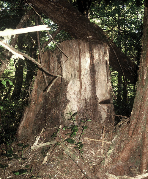
old-growth stump—note springboard notch on right
In the early days, steep topography was an asset. All trees would be felled downhill. If they needed help getting to the water after the branches had been trimmed, a series of smaller logs placed perpendicularly sometimes notched to keep the aim true and often greased—sometimes with whale oil (“greasing the skids”)—would aid the skidding process, getting the log to a common transport depot. At first, gravity was often sufficient to get a tree to the water; if not, trees were harnessed to horse and ox teams. “Donkey engines,” stationary steam or diesel motors with giant drums and cables, soon replaced the livestock. Today, giant bulldozers skid the timber.
Or, sometimes, helicopters. Expensive though it might seem, as both the distance from prime timber to the sea and the cost of extending access roads in increasingly rugged terrain have increased, heli-logging has come into its own. Without extensive logging roads, impact and erosion are minimized or eliminated. In some areas, under some resource management regimens, helicopters are the only viable skidders. But beware if you find yourself under their flight path. Newly guillotined and choked by a single cable, heli-logs rain down a constant shower of bark, branches, and detritus. In many cases, these prime logs are deposited directly onto a log-carrying barge for transport to a sawmill.
Self-loading log barges, 200 to 400 feet in length with crews of two to four, and log freighters—bigger still—are often seen in the distance, cruising outside waters. Empty, they resemble castle moat bridge supports with buttressing towers and cranes at the fore and aft ends. At a distance, empty or full, these squat castles unexpectedly puzzle. The logs are stacked crosswise on the decks and are unloaded by flooding water compartments on one side of the ship. The resulting list, or tilt, slides the logs off. Log ships transport unmilled logs over long distances or rough water, often to Asian markets. US regulations require Alaskan timber to undergo “primary processing” prior to export, usually into squared-off logs called cants. (Native-owned timber, according to the Alaska Native Claims Settlement Act, is exempt; most of the high-quality native timber is shipped as raw logs to Japan.)
Logs are stockpiled at “booming” areas, the nearest protected waters adjacent to the cutting site or, at the receiving end, the lumber or pulp mill. Booming areas are defined by and subdivided into holding pens by perimeter logs strung together with cable and marked into lots for easy identification. At the Powell River pulp mill, exposed to the full fetch of the Strait of Georgia, the anchored, rusting hulls of surplus WWII merchant marine ships create the booming ground.
Transit between booming grounds is a tedious, labor-intensive, low-tech affair with long reaction times and minor episodes of tragic farce not unlike herding sheep, complete with maverick escapees. Transport holding pens, as above, sometimes and seemingly absurdly strung together in lengths as long as three, are hitched to a single tug for tow. Tugboats are not the most nimble wranglers. Basically gargantuan, seaworthy diesel engines, they are long on raw power but short on balletic grace. The log bundles are not hydrodynamic, immeasurably resist organization, and retain oodles of inertia. Kayaks often outpace tugged log bundles. Avoid them like drunken mendicants. Their reaction times are measured in increments of an hour, and current, wind, and sea conditions can discombobulate the entire jury-rigged affair. Getting started and docking a load are tests of patience and seamanship. For longer voyages and before the introduction of self-loading log barges and ships, the log bundles—with a great deal of pressure—were chained together into a cigar-shaped, single towable mass called a Davis raft, measuring 280 feet long by 60 feet wide and 30 feet deep.
Various entities own—and manage quite differently—different portions of the Inside Passage forests. In the state of Washington, besides national forests, parks, and various other federal, state, and local entities, a great deal of forested land is privately owned. Tacoma-based Weyerhaeuser owns much of its resource thanks to government subsidies, in the form of undeveloped acreage, granted the railroads after the Civil War as a quid pro quo for building line extensions. In 1900 Frederick Weyerhaeuser bought 900,000 of these acres from the Northern Pacific Railroad. Weyerhaeuser, Georgia-Pacific, and others now primarily manage “tree farms” on their deeded land.
British Columbia’s government owns 95 percent of the province’s forests and manages them through the BC Forest Service. Far from affording a venue for conservation, government ownership sometimes seems a detriment. Canada has always been imbued with an interventionist economic philosophy, in the belief that nothing gets done unless government lends a helping hand. Consequently, government takes an active part in growth and development by subsidizing resource exploitation. Leases to timber corporations such as MacMillan-Bloedel, BC Forest Products, Crown Pacific, and Western Forest Products, at exceptionally good terms, are the norm. “Dumping!” cry the Americans, and in May of 2002 the United States imposed duties averaging 27 percent on Canadian imports. “It’s the biggest trade battle on the planet,” said Pierre Pettigrew, Canada’s then trade minister.
On the other hand, government has lately been intervening more and more for conservation, setting aside more land for parks and removing acreage from consideration for timber leases. In 1997, under the Forest Practices Code, the Inside Passage (in the stricter sense, not the entire north coast) was declared a scenic area, a designation that means scenic integrity and not timber production will be the paramount planning guideline. According to the BC Forest Service, now only 16 percent of the north coast forest is considered available and suitable for logging.
The Tongass National Forest—the largest national forest in the United States—started life in 1902 as the Alexander Archipelago Forest Reserve. In 1907, Teddy Roosevelt substantially increased the reserve to create today’s Tongass National Forest, which encompasses 80 percent of all the land in Alaska’s southeast. Back then, “reserve” and “national” didn’t quite mean what they mean today.
As a timber resource, the great forests of the Lower 48 were quickly disappearing. So it seemed logical that the vast forests of newly acquired Alaska would continue to supply demand. At one time, laissez-faire market forces would have been allowed to operate unhindered. But in 1873, Karl Marx, in the first volume of Das Kapital, argued that a brain was needed behind Adam Smith’s “invisible hand” to control and guide it so it would make better choices: government. With policies developed centrally at the national level by disinterested experts, instead of the anarchy of self-interest of countless citizens, exploitation and extraction of the new resource could be maximized with greater efficiency. “Reserve” meant “reserved for exploitation” and “national” meant “officially nationalized for exploitation.” The US Forest Service was the entity of experts created to manage and promote economic exploitation of forest resources. From the beginning, they tried to bring economic development to Southeast Alaska by offering cheap timber to companies willing to build local mills.
But that now-handcuffed invisible hand was proving hard to direct. Even with subsidies, the distance, rugged terrain of Alaska, and cheapness of other timber sources attracted only local hand loggers and mom-and-pop sawmills to the Tongass. World War II and the postwar economic boom increased exploitation, but apparently not enough for the economic planners in Washington, D.C. In 1947, Congress passed the Tongass Timber Act, which not only authorized the Forest Service to offer generous incentives to timber companies, but also guaranteed that the subsidies would not deplete the agency’s annual funding. In one stroke of the economic planning pen, large-scale logging was now truly viable in Alaska.
Two takers stepped up to the trough: the soon-to-be Louisiana Pacific Paper Company and the Alaska Pulp Company (APC), a newly formed Japanese consortium incorporated in Juneau. The 50-year contracts that each were awarded built pulp mills in Ketchikan and Sitka, and brought growth and economic development to the panhandle. So as not to completely eliminate competition, the Forest Service reserved one-third of its “crop” for smaller operators. But free government money and a guaranteed majority stake are hard to resist, and corrupt completely. By the 1970s both Louisiana Pacific and APC had conspired to corner the market by buying out or forcing from business all competitors, then used the no-longer-competing competitors to manipulate federal timber auctions and thereby artificially depress the pulp market price. With an intricate but fraudulent shell game, both companies reshuffled vast profits to parent corporations to make the mills appear barely profitable and thereby secure lower timber prices. Since lower prices encourage consumption, panhandle forests suffered.
To make matters worse, the Alaska Native Claims Settlement Act awarded half a million acres of prime forest in Southeast Alaska to local native corporations. They soon set out to substantiate the fears that were the original impetus for the establishment of the failed reservation system: they logged with a vengeance in an attempt to make their corporations profitable. Within 10 years they had clear-cut as much as Louisiana Pacific and APC combined had razed since the 1950s.
But the tide was turning. During the late 1950s and early 1960s, people were beginning to value pristine forests not just as sources of timber and jobs but also for recreation, biodiversity, undevelopment, and just for their own sake. These nouveau values were exemplified by the Sierra Club, which now attracted legions of conservation-minded folk. The organization, founded in 1898 for hikers and climbers, had become a political powerhouse by 1960. Using a combination of lawsuits and lobbying, the Sierra Club was instrumental in beginning to reverse the status quo. In 1964, Congress passed the first Wilderness Act.
The conservationists’ unlikely ally was an independent logger whose 1981 lawsuit against the pulp mills exposed both the economic inequities in the Forest Service’s system and the fraud and corruption in Louisiana Pacific and APC. As more people learned that the Forest Service was losing millions of dollars on the Tongass timber program, taxpayers joined conservationists, hunters, fishermen, and small businesses in demanding reform. In 1984, Congress designated 5.4 million acres of Southeast Alaska as wilderness and turned the 2-million-acre Glacier Bay National Monument into a national park. But the real victory came in 1990 with the Tongass Timber Reform Act, which designated a further 1 million acres as wilderness, abolished the $40 million timber fund, and decreased the target cut. By 1997, Forest Service reforms, the burden of unresolved lawsuits, and accumulated pollution fines forced both companies to close their Alaskan pulp mill operations.
In 1999, a new Tongass Land Management Plan extended a broad panoply of protections to panhandle forests. Once spreading to more than 2,000 acres, today the average size of a Tongass clear-cut is 80 acres, and only 10 percent of the Tongass is scheduled for harvesting over the next 100 years.
Fishing
For a kayaker, fishing for fish that don’t eat is a true challenge. The most effective method for bagging a salmon along the Inside Passage is to beg, buy, flirt, or somehow talk your way into a salmon from a passing commercial fishing boat. Most will proudly offer a token of their catch. Gillnetters reeling in and clearing their nets are excellent prospects. Sometimes they snag out-of-season species that must be released. Most of the time the unfortunate fish is so damaged it can’t survive and, hating to waste an otherwise fine fish, the skipper is more than happy to see it somehow end up in a paddler’s larder. Keep a supply of plastic garbage bags handy in which to pack the salmon so as not to contaminate the kayak with fish smell. One hour or more before camping, stop at a handy beach to clean, fillet, cut up, and pack the meat in a small plastic bag. Discard the offal responsibly and burn the plastic garbage bag. Though it’s hard to beat barbecued salmon, you don’t want to attract uninvited ursine guests. Try boiling, er, poaching. Cleanup is a cinch, and the salmon is every bit as delicious. Season with salt, lemon, and pepper.
Commercial salmon fishing is strictly regulated according to political jurisdiction, season, fish stocks, salmon species (see Chapter 1 and Appendix D for habits and identifying features of each salmon variety), and methods of fishing. Three methods are commonly employed along Inside waters: trolling, gillnetting, and purse seining. Each type of boat is quite distinctive, but all are extremely common. They vary in length from 30 to 50 feet, with purse seiners sometimes reaching 100 feet.

the most effective way to catch a salmon from a kayak
Trolling is the simplest method. Two to four tall trolling poles, lowered to 45° for fishing, distinguish salmon trollers. Each pole deploys a weighted line with multiple lures. Although salmon don’t normally eat during the spawn, they retain a strong instinct to snap. The lines are hauled periodically, either by hand or with power winches—gurdies—and fish removed. Unlike netters, salmon trollers are not restricted to a certain area and range far and wide, with a crew of one or two for up to a week. An Alaskan hand-trolling license is relatively cheap and easy to acquire, allowing almost anyone to become a commercial fisherman. Elderly pioneers supplementing retirement income, well-off suburbanites writing off expensive cruisers as a business expense, aging hippies in rotting hulks, and men undergoing midlife crises all contribute to Alaska’s colorful cast of independent fishermen.
Gillnetters fish with a fine rectangular nylon net about 1,000 feet long by 20 wide. These are deployed in a straight line across a likely salmon travel path to snag the commuting fish by their gills. Floats—with a large, distinctive orange one supporting the end—hold the net up. Every one to four hours the nets are hauled up by a giant power drum—the gillnetter’s distinctive identifying feature (see photo on page 265)—and picked clean. Many are outfitted with trolling gear as well. Gillnetters often work in concert. Prior to the adoption of gasoline engines, oar and sail propelled trollers and gillnetters.

purse seiner
Purse seiners are more complicated, crewed by three to seven, and aided by a tubby skiff tender. Each fishing episode is a frenetic affair. When a school is located, the trap—a net about 1,200 feet long by 70 feet deep, supported by movable booms and shaped like an old-fashioned net purse (or scrotal sac) when closed—must be quickly set. The tender circles the prey widely with one end of the net and closes the circle, returning the net’s end to the seiner’s boom. The net is supported by floats and held vertically by weights at the bottom. If the set is successful, a line channeled through metal rings then draws the bottom of the purse tight. The purse is then hauled in and the catch sorted. No matter what the weather, seining crews work in complete foul-weather gear. Nets always capture jellyfish that inevitably end up cascading gelatinous stinging slime onto the crew. Purse seiners, easily identified by their nets aloft and pendant (or adjoining) tender, account for the largest proportion of commercially harvested wild salmon.
Some fishermen work independently, and others are on contract to commercial fish companies; all deliver their catch to fish-buying tenders and, in more remote areas, scows, whose crews often set their own lures: beer, liquor, cheap groceries, hot showers, whatever the market calls for. We ran into two competing fish-buying scows in Foggy Bay, halfway between Prince Rupert and Ketchikan. Though they may not retail fish, when not busy buying they might sell a kayaker some groceries or a shower.
Salmon are retailed fresh, smoked, frozen, or canned, depending on their quality. One outfit, kind enough to invite us in for a bed and a feed, specialized in smoked, spicy teriyaki king (Chinook) salmon. I couldn’t get enough of it. After dinner, a corporate floatplane landed at the dock and disembarked two formally suited and smiling Japanese, one with an attaché bag handcuffed to his wrist. “Our client,” whispered our generous host. Best smoked salmon I’ll ever taste.
In Alaska, the number of commercial fishing permits is limited. Someone wanting to enter the trade must buy an existing license from someone else. Prices reflect current demand. Back in the 1980s, power-trolling permits cost about $20,000. Catches are further limited by a complex schedule of openings and closings for different areas, different fishing methods, and different species, translating into long hours of intense work followed by extended periods of costly inactivity.
Since 1980, salmon farms have become a common sight along the BC coast. Salmon aquaculture was first developed in Norway and—when worldwide wild stocks began to shrink—spread to the UK, Chile, and Canada, where the helping hand of government provided generous subsidies. The fish are raised in net pens supported by rafts and are fed pellets just like in a home aquarium. When natural populations made a comeback in the 1990s, BC’s salmon farms experienced serious consolidation. Today (2018) there are only 80, but they supply a disproportionate majority of commercially marketed salmon. Canada is the fourth-largest producer of farmed salmon in the world. For the five years between 2011 and 2015, the annual average of farmed salmon produced in all of Canada was 122,300 tons with a value of $735.2 million. Though controversial, Atlantic salmon are the favorite fish species for farming due to their docility in tight quarters, larger size, and resistance to disease. As an artificially introduced species on the Pacific Coast, escaped Atlantic salmon pose the dangers of predation, competition, displacement, and increased risk of disease to the native populations. Consequently, Alaska bans finfish aquaculture and Washington very stringently regulates it. In 1999, sea lice were reported on wild salmon near Vancouver Island fish farms; Atlantic salmon are the suspected culprits. It is one more point of contention in the ongoing US-Canada fish wars.
The commercial salmon industry along the Inside Passage dates back to the 1820s, when the Hudson’s Bay Company shipped salted salmon to markets in Hawaii, China, Australia, England, and America’s Eastern Seaboard. The salmon, more often than not, arrived in less than prime condition. Although Nicolas Appert had invented the canning process in 1809 under the funding and direction of France’s war department, the technology spread slowly. For one thing, Napoleonic France was not known for sharing much of anything other than grief and subversion; additionally, the strange new process was suspect. It would be another 50 years before Louis Pasteur was able to explain why the process worked.
The first salmon cannery in British Columbia opened for business in 1870 near Vancouver. Canneries in Puget Sound—at Mukilteo in 1877—and Alaska—at Sitka and Klawock in 1878—soon followed. By 1901 there were 70 canneries along BC’s coast, and Alaska wasn’t far behind. Haines, Wrangell, and Petersburg all had canneries. At one time, during the 1920s, 25 canneries were operating on Prince of Wales Island alone. In 1940, Ketchikan had 13 canneries. Today, few active canneries survive, while the rest, haunted carapaces of an abandoned industry, are succumbing to fecund decay and encroaching salal, alder, and berry bushes.
By the end of WWII, overfishing was taking its toll and stocks began a gradual, determined, and ultimately precipitous decline. Fishermen and canneries went bust. Salmon prices soared. Governments and private interests poured money into research. Finally, in the 1970s, hatcheries succeeded in producing viable salmon that could be reintroduced successfully. By the 1990s, many stocks were well on their way to recovery. But the canneries never came back. By and large, modern refrigeration and freezing have superseded Appert’s invention. You can tour the Deer Mountain Hatchery in Ketchikan and the Douglas Island Pink and Chum Hatchery in Juneau.
Halibut fishing is second only to salmon in weight yield and importance. A bottom-feeder with both eyes on its “top side,” halibut can reach 500 pounds. Since it lives as deep as 3,600 feet, special single-hook fishing techniques are required to bag one. Its meat is white, flaky, and exceptionally delicious.
Oyster and, to a lesser degree, mussel farms are found all the way from Puget Sound to the Wrangell area. Because they need warmer water, most of the farms are south of Port Hardy. Alaskan oyster farming began near Ketchikan in 1930 from imported Japanese spat (baby oysters); today, Alaskan-reared Pacific oysters are grown from spat imported from the Lower 48. The farms are modest affairs, invariably marked if the critters are raised on the bottom, or recognizable as floating rafts.
Finally, probably the most ubiquitous—albeit humble—landmarks (seamarks?) along the entire paddle are shrimp and crab pots. You can spot these by their telltale floats, sometimes in the unlikeliest of places, which mark their location and anchor the trap. Shaped like big cheese wheels, the traps are crafted of wire mesh and baited. A funneled one-way opening secures the catch.
As of 2011, fishing was the number one private sector employer in Alaska, providing more jobs than oil, gas, timber, and tourism. The 2009 harvest of 1.84 million metric tons of fish and shellfish was worth $1.3 billion.
Mining
When Ginger and Dana Lamb set out to kayak from San Diego to Panama (see the Introduction) during the Great Depression, they supplemented their meager resources with a .22 caliber rifle for hunting and a gold pan for spending money. Today’s kayakers—some, at least—are not quite so penurious.
However, walking-around money is always a welcome addition to any excursion. You too, in the time-honored tradition of the Lambs and the hundreds of thousands of prospectors that made their way up the Inside Passage, can supplement your pocket money by placer mining for gold. All you need is a pan and a small, folding army surplus shovel—or the sturdy blade of a paddle.
Placer-mining is the oldest method of recovering gold from alluvial deposits. Gold, locked in strata high up in the mountains, is freed through erosion and wends its way down creeks and rivers. The more turbulent the water, the heavier the material it can carry. As the stream slows, the heaviest particles settle out first. Placer-mining takes advantage of this principle. Panning employs a pan or a batea (a pan or basin with radial corrugations) in which a few handfuls—or a shovelful or paddleful—of dirt and a large amount of water are placed. By swirling the contents of the pan—as if aggressively panhandling—the miner washes the siliceous material over the side, leaving the gold and heavy materials behind.
The first gold strike along the Inside Passage, in 1850, was at Gold Harbour, in the Queen Charlotte Islands. It was short-lived. Only the original discovery panned out. Six years later, Indians discovered gold along the Fraser River and set off a gold rush that brought nearly 30,000 prospectors in one summer to the present-day Vancouver area. Many were disillusioned forty-niners. Most remained disillusioned.
Wrangell was originally founded by the Russians as a tiny outpost of empire to strengthen their claim against Hudson’s Bay Company incursions. It was immediately—and diplomatically—leased to the Brits. Gold strikes up the Stikine River and in the Cassiar Mountains in 1861, and again in 1873, ballooned it into a tent city of 15,000. During the last half of the 1860s and through the 1870s, there were many more gold discoveries along the BC coast, but none compared to the 1880 strike in Juneau, Alaska. In October of that year, a Tlingit guide led Sitka prospectors Richard Harris and Joe Juneau to the mouth of soon-to-be-named Gold Creek. It was a fabulous strike, and Harris and Juneau staked their claims along with a 160-acre townsite for the expected rush. That first year yielded $2.5 million in today’s dollars.
Juneau’s mother lode, the gold-bearing strata that fed the placer deposits, were the mountains immediately backing the new town: Gold Creek’s entire watershed, plus several adjoining watersheds. When placer mining’s easy pickings ran out, prospectors tackled underground lode mining, a much more time-consuming and capital-intensive affair. The extra effort afforded the necessary time for the development of a substantial settlement. Ironically, the first big underground mine was not behind Juneau but in front of it, across Gastineau Channel, on Douglas Island. Big underground mines on Mount Roberts, behind Juneau, soon followed. The not-so-pure gold ore required purification. So, in 1889, the Tacoma Smelting and Refining Company set up shop in Puget Sound to refine gold at first, and later, as those deposits became depleted, silver, lead, and copper from the Juneau-Douglas mines. Mining in Juneau continued for 64 years, until it ceased in 1944. Paddling into Alaska’s capital, one of the first sights you’ll encounter is the ruin of the Alaska Juneau Mining Company, along with numberless adits, looming vertiginously over the city.
We made a beeline for Gold Creek to see where all the commotion had first started. What a grand disappointment! I suppose it was inevitable that the stream suffered during the gold rush, but the solution almost seems worse. One sorry little sign commemorates Juneau’s founding. The channel has been unelaborately and inartfully lined with concrete, without a thought for the poor salmon. We watched the pathetically heartbreaking attempts of a dozen superpiscine salmon fighting to make their way upstream. There wasn’t enough water in the wide channel for the fish to gain a fin- or tailhold. With Juneau’s receptivity to tourism, it’s a wonder no restoration has been attempted. Amazingly, one local paddler told us that the city had been offered a grant for just such a project but unexplainably turned it down.
The biggest gold rush of all along the Inside Passage burst upon the world in 1897 but did not take place anywhere near the Inside Passage’s protected waters. The previous year, when “Lying” George Carmack and his sidekicks, Skookum Jim and Tagish Charley, boasted of striking pay dirt at a small creek just east of Dawson City, Yukon, no one believed them. Until, that is, Carmack showed off a thumb-sized nugget of pure gold he’d picked off a protruding bit of bedrock. Local prospectors, working at Fortymile just west of Dawson, rushed to stake out the best claims. But it would take nearly a year and a 1,700-mile voyage down the Yukon River, plus the passage to San Francisco and Seattle, before news of the strike hit the press. The dispatch came in the form of suitcases, carpetbags, packing cases, bottles, cans, and every other type of container imaginable filled to bursting with 2 tons of pure gold unloaded at the San Francisco docks. The stampede was on.
Dawson City was not the most accessible destination. The simplest route was up the Pacific to Skagway or Dyea, then 20 miles up and across the Coast Range through Chilkoot or White Pass, and another 450 miles north down the Yukon River to Dawson. Regular steamship service, inaugurated during the Juneau rush, quickly reached capacity.
So more vessels provided passage. Over 100,000 treasure seekers set out for the Klondike; maybe 40,000 reached Dawson City. As more and more ships—some barely meriting the designation—plied their way north, those sailing in winter, and particularly those not fully up to the rigors of sailing Outside, rediscovered the protected waters Inside. Thus was the truly greatest bonanza of all unearthed—Inside Passage tourism.
Though seemingly much more mundane than gold, the discovery of coal along the Inside Passage in some ways had a greater and more lasting impact. Welsh coal, at tremendous expense, fed all the metallurgical industries in the nascent colony. In 1849, one year before the first gold strike in the Queen Charlottes, a Heiltsuk native at Bella Bella’s Fort McLoughlin observed a blacksmith impose his will on a piece of iron with the help of black rocks. When the native found out that the coal came from halfway around the world, he told the smith that there were black rocks a lot closer, near his home by present-day Port Hardy. The Hudson’s Bay Company confirmed the find, established Fort Rupert to protect the site, and imported English miners, as they doubted that the natives would make good coal miners. Both the Beaver and the newer trading vessel, the Otter, were immediately converted from wood to coal—one small step in the conservation of the BC forests.
Three years later, a much higher-quality coal was discovered at Nanaimo, so the HBC built a fortification, the Bastion (still there), and transferred the miners down from Fort Rupert. The Nanaimo seam proved extensive and very productive well into the twentieth century. Nanaimo coal was exported to Puget Sound and San Francisco. Kayakers can visit some of the preserved adits—one tunnel is reputed to lead all the way across Newcastle Island Passage to Nanaimo—on Newcastle Island, named after the miners’ hometown in England. Coal was also later discovered at Bellingham in Puget Sound.
For such a small place, Newcastle Island was a cornucopia of mineral goodies. The search for flawless quarry stone for the newly proposed San Francisco mint ended in 1869 with the discovery of perfect sandstone on Newcastle. The quarry supplied large monolithic blocks for much of the Northwest’s grandiose public architecture—including the towers of Christ Church Cathedral in Victoria—until 1932, by which time the coal mining and stone quarrying had totally trashed the island. In 1931, the Canadian Pacific Steamship Company bought what was left of the little island and developed it into a park resort. The sandstone quarry exhibit on the park’s perimeter walk is very impressive.
The largest and most visible mining operation that a paddler will see along the Inside Passage is on the approach to Texada Island. We joked that from a distance it looked like the largest kitty litter quarry in the world. Since 1887, Texada has yielded huge amounts of high-quality limestone. Today it ships 3 million tons a year to the BC market for use in the pulp mills, agriculture, and the construction industry—for quicklime, cement, quarry rock, and even marble (due to part of the limestone strata adjoining an igneous lens), limestone’s metamorphic reincarnation.
The region’s most controversial open-pit mining operation—which an Inside Passage paddler is unlikely to encounter—is located deep in Misty Fjords National Monument. In 1974, the US Borax Corporation patented what was later identified as the largest molybdenum deposit in the world—perhaps 10 percent of known reserves—at Quartz Hill, about halfway between Behm Canal and the Canadian border. Molybdenum is used to harden and retard the corrosion of steel and other alloys. The claim remains valid since it predates the National Monument designation. As of this writing, market prices preclude any mining activity.
The Coast Range and its offshore islands have been heavily mineralized due to tectonic forces at the Pacific-North American Plate interface. In addition to gold, molybdenum, and coal, large deposits of silver, copper, lead, iron, zinc, uranium, asbestos, and jade have, in most cases, been mined and exhausted. Presently there is very little mining going on along the coast, with the notable exception of Texada Island and a potash mine on Ridley Island outside Prince Rupert.
Tourism
Tourist: One that travels from place to place
for pleasure or culture.
—WEBSTER’S THIRD NEW INTERNATIONAL DICTIONARY
Arguably, one of the earliest and most famous self-described tourists to visit the Inside Passage was John Muir. Muir steamed to Wrangell and canoed to Glacier Bay in 1879, when the Alaska purchase was only 12 years old. Many more were soon to follow, albeit not in quite his frugal style. Muir’s account of his visit proved so inspiring that steamship companies began to offer summer tours up the Inside Passage. The first was the steamer Idaho, which came north in 1883. The tourism industry was launched. By 1889, 5,000 tourists a year were making the trip up the Inside Passage. According to Tourism Vancouver, over 1 million cruise ships visit the Inside Passage annually. Mind you, that is cruise ship with a small “c”—anything from the gargantuan liners of the Royal Norwegian Line to, yes, solitary kayaks and every imaginable craft in between.
Cruise ships come in many categories. The big behemoths—many painted an imperious and dazzling white—dominate, if not in numbers, at least in sheer size. British Columbia and Alaska ferries qualify—and they can barely keep up with demand. Were it not for the sheer number of do-it-yourself, boatless summer visitors, ferry bookings would not require advance notice. A variety of smaller-scale cruises cater to the educational, ecotourism, and mother-ship kayak touring markets. An increasing number of kayak tour companies find a way to scratch out a living. A few offer land-and-water tour combos. Finally, in sheer numbers, private boats—from elaborate sailing rigs and luxurious yachts, to ambitious, modest-sized inboard and outboard vessels occasionally testing their limits, to trans-Inside Passage kayakers, rowers, and canoeists—fill out the flotilla.
In spite of the clarification, the numbers are still staggering. Nearly 1.25 million cruise ship (with a capital “C”) passengers toured the Inside Passage in 2017. Holland America and Princess Cruises alone made over 1,000 port calls—combined—in Alaska in 2017, with Juneau and Ketchikan together hosting nearly that many cruise ship stops during the 2017 summer. Little Ketchikan, with a population of only 7,000, is sometimes overwhelmed by between 10,000 to—some residents fear on current projections—20,000 visitors a day! Cruise ships carry about 2,000 passengers per ship with another 1,000 as crew. However, the ships are getting bigger: Royal Caribbean’s Ovation of the Seas, with a capacity of 5,000 (1,500 crew), is slated to visit Alaskan waters in 2019. While most of these self-contained floating cities measure about 700 feet in length and float 20 stories tall, the Ovation of the Seas stretches to 1,142 feet. When several vessels are in port simultaneously, they dwarf Alaska’s capital city’s buildings. The resident population of most towns along the Inside Passage doubles during the tourist season to accommodate the influx. Still, between May 1 and September 30, cruise ship passengers will spend an average of $1,233,000 every day in Juneau alone. Docking facilities in many towns, which once accommodated both ferries and cruise ships, have had to be rebuilt with separate berths. Plenty of Alaskans are grateful for the visits; others have mixed views of the cruise ship crowds.
With good reason. The sheer numbers are starting to sully the very beauty that brings visitors north in the first place. A typical cruise ship generates about 210,000 gallons of raw sewage a week, lesser amounts of oil, assorted hazardous wastes, and more than a million gallons of gray water. Not all ships are as fully self-contained as they ought to be. In 1998, Holland America pleaded guilty to two felony counts of illegal dumping in waters near Juneau. The next year, Royal Caribbean pleaded guilty to seven felony charges for dumping oily bilge water and toxic chemicals into Southeast Alaska’s waters. The company had rigged ships with secret piping systems to bypass oily water separators, and then falsified records to conceal the dumping. In 2000, 79 water samples from 80 cruise ships’ wastewater storage tanks—stuff normally expelled into the ocean—exceeded federal minimum standards for suspended solids and fecal coliform bacteria. Some samples exceeded the criteria by 50,000 times! But, to most Alaskans, the very worst, the truly ultimate tragedy, occurred when a cruise ship struck and killed a 45-foot pregnant humpback whale near the entrance to Glacier Bay National Park.
In 1996, the National Park Service, reacting to increased demand, made plans to increase the number of cruise ships allowed into Glacier Bay National Park by 30 percent, from 107 to 139 per season. Fearful that the consequences could be dire, the National Parks Conservation Association, a public interest group, filed suit on the grounds that no environmental impact study had been done. In 2001, the Ninth Circuit Court of Appeals agreed. The NPS had to roll back cruise ship visits and complete an environmental impact study. The state of Alaska also stepped in.
In June 2001, Governor Tony Knowles convened a special session of the state legislature for the express purpose of addressing water pollution, air pollution, and trash disposal from cruise ships. The legislation passed and immediately went into effect. Now an even tougher measure, based on a 1999 $5 per-passenger tax levied by the city of Juneau, is being proposed through a statewide ballot initiative. As much as a $50 per-head tax would be imposed on tourists entering Alaska on cruise ships. The Northwest Cruise Ship Association believes such a tax would deter visitors. With cruise ship traffic increasing at a rate of about 10 percent per year, many voters don’t seem to think so.
When a cruise ship sails past, most kayakers are struck by the contrast between themselves and the passengers. Though both share the same purpose, the methods differ—vastly. Cruise ship tourists generally admire kayakers but think they’re a tad crazy. Kayakers’ attitudes toward cruisers range from dismissive to contemptuous. What’s it like to trade places?
A typical cruise lasts one week, makes six stops of 8 to 10 hours, and averages, at the moderate end, about $800. According to Peter Schmit, a passenger in 2002:
Our ship, built in late 1999, was home to 2000 passengers, with a crew of 950. It is literally a city at sea. It has its own sewage treatment and water desalination plants, eight restaurants, 12 bars and lounges, two swimming pools, a spa, a beautiful fitness center, running track around the perimeter (3.5 laps made a mile), a library, gambling casino, a 1000-seat theater, and way too many shops. The 80,000-ton ship cruised at about 22 miles per hour.
Most cruise ship tourists rave about their experience and would highly recommend it. Though it’s definitely not my idea of a good time, it’s no wonder the industry is growing so fast. Even my 70-year-old mother cruised to Alaska. More amazingly, some kayakers are even extending cruisers the hand of friendship. Lately, scuttlebutt has it that one Alaskan Inside Passage kayaker has taken to promoting his book with slide and lecture presentations on cruise ships.
Natural History
The Alaska Panhandle has always seemed an odd extension of Alaskan territorial integrity. More a historical accident than an integral part of the main Alaskan landmass, at one time it was Alaska. It was the rest of Alaska, the landmass west of 141° longitude and north of the panhandle—in effect, Seward’s Icebox—that, pretty much by default, was lumped together with the rich southeast. Southeast was hospitable. It was home to as many salmon as the mainland had mosquitoes, it nurtured forests that made the rest of Alaska look like it was on chemotherapy, and it was home to the sea otter, that little floating gold mine that brought the Russians over in the first place.
Although the Russians made inroads north of Southeast, there was little to attract or keep them there. And they never ventured east of the panhandle. Not only was the Coast Range impenetrable, but British westward expansion put paid to that notion. The brewing controversy was negotiated in 1825 under the auspices of the Convention of February, when the Russians and British settled on a serpentine border that addressed each power’s concerns. Russia wanted the entire littoral for fishing and whaling, and marine access to native communities for trading; Britain was little interested in the coastline, but wanted as much of the inland terrain as possible to maintain its fur trade. The new border had only been cursorily confirmed at the time of the Alaska Purchase. When gold was discovered in the Klondike and thousands invaded the panhandle, a serious border dispute arose. There was even talk of war.
When Britain rejected war out of hand and offered to arbitrate, Canadians took up the offer because they thought Britain was on their side. The United States also agreed because they had not rejected war as an option, and had in fact just won a war that added Hawaii, the Philippines, Puerto Rico, and Cuba, and had a new president, Theodore Roosevelt, that carried a “big stick” in foreign policy. Canada, wanting sea access for the Yukon, claimed the heads of the major inlets; the United States wanted the Russo-British line honored. Negotiations were further complicated by the fact that Canada, at this time, still lacked full treaty negotiating power. Britain, in 1903, sided with the United States; however, the boundary survey was not completed until 1914.
The Dixon Entrance, the second and smaller of the two main bodies of open water to be crossed on the Inside Passage, roughly marks the US-Canada boundary. North of it, a very dense maze of islands sets the panhandle apart from Canada. According to the US Forest Service, there are 2,000 islands along Alaska’s southeast coast. The Alexander Archipelago, as they are collectively known, is striking in its cohesiveness, extent, and the size of the major islands. Prince of Wales Island, at 2,770 square miles, is the largest. Paleontological excavations at El Capitan Cave on Prince of Wales Island reveal that there were black bears there 20,000 years ago and brown bears 40,000 years ago, indicating that there were ice-free locales along the Inside Passage during major glacial advances. Ironically, today along the panhandle, brown bears are limited to the mainland and the ABC Islands—Admiralty, Baranof, and Chichagof, with all three measuring just a tad smaller than bear-free Prince of Wales.
After central British Columbia, the panhandle section might seem overpopulated, with 70,000 residents in 33 communities. Fortunately, nearly all the people are concentrated in relatively large towns along our route—Prince Rupert, Metlakatla, Port Simpson, Saxman, Ketchikan, Myers Chuck, Wrangell, Petersburg, Junea, and Douglas. Campsites are not as scarce as in BC, but neither are they as plentiful as in the Gulf Islands.
Southeast Alaska is different—and not just in contrast to the main part of the state, as previously noted. Latitudinal changes, subtle in quality and degree—none quite so striking as the disappearance of the madrona north of Desolation Sound—have been accruing during our progress north. The “land of the midnight sun” effect is striking. On June 21—the longest day of the year—the sun rises about 4 AM and sets about 10 PM. Because the sun is circling just below the horizon, most of the few nighttime hours are in twilight. No need for a flashlight. At the other end of the year, midwinter Juneau has only about six hours of daylight, with sunrise at about 8:45 AM and sunset at about 3:00 PM.

dixon entrance lunch stop
Alaska weather is just a tad brusquer, egged on no doubt by the nearly 3,000 square miles of the Juneau and Stikine Ice Fields. Rain and fog are more frequent. Low-pressure fronts, which in summer break through the Pacific High about every two to six weeks along the lower Inside Passage, occur at intervals of one to three weeks in Southeast. Although these fronts usually last only a day or two, in Southeast they can stall out and linger longer. Accompanying winds are commensurately stronger. In lower BC, low-pressure fronts typically generate winds of 20 to 25 knots; in Southeast, the same fronts blow harder, around 30 knots, with occasional summertime gale-force blows. Watch out for these.
The Alexander Archipelago is very protected, particularly along our route, which courses as far east as possible. However, many of the channels and passages are quite wide and long. The accompanying fetch and exposure to the force of storm winds can create rough seas. Crossings of Portland and Behm Canals, Frederick Sound, and Stephens Passage are long enough for conditions to change during a crossing. Always be aware of diurnal and atmospheric wind changes.
With a handy wrist barometer, such as the Suunto, you can monitor atmospheric wind. Wind velocity is directly proportional to the rate of barometric pressure change—up or down. Falling pressure of 1 millibar per hour equals 20- to 30-knot winds; 2 millibars per hour equals 35- to 45-knot winds; while 3 millibars per hour translates to 50- to 60-knot storm winds. On the rising scale, 1 millibar per hour generates gale winds of 25 to 40 knots.
After cruising in BC and listening to Environment Canada’s marine weather forecasts, Alaskan forecasts might be slightly disappointing. Environment Canada prepares forecasts several times a day and broadcasts continuously on VHF weather channels. Lots of repeater stations provide adequate coverage all the way up to Ketchikan. In contrast, the National Weather Service in Juneau issues only one forecast a day, at 5 AM, and repeats it every five minutes on Weather Channel 1 or 2. Transmitters are located only in Haines, Juneau, Sitka, Wrangell, Ketchikan, and Craig, and repeater stations are few, so the effective range of the broadcast stations is only about 20 to 40 miles.
The observant will notice other subtle changes. The timberline drops, sometimes to only 2,000 feet, and the boreal mix changes. While the more southern forests are primarily composed of Douglas fir, the dominant species in Alaska are western hemlock and Sitka spruce with a scattering of red cedar, Alaska cedar, and mountain hemlock. Climax forests—old growth, where these can still be found—have smaller trees: only 200 feet tall and 5 to 8 feet in diameter. There are lots of salmonberries (similar to blackberries but colored orange to dark red), elderberries (bitter), and several varieties of blueberries and huckleberries, all in impenetrable thickets. Southeast’s forests have no poison oak or poison ivy.
Campsites in Southeast are a tad more abundant. Though vegetation remains a barrier and much of the ground is rough, the steepness of the topography eases. In a pinch, bivvy spots are plentiful. In this chapter, many potential camps are not marked—there are just too many. Some possibilities will be indicated in the text, but only definite campsites are marked on the accompanying maps.
The Alaska Panhandle is proud Tlingit country. Strong and bold enough to hold their own against most invaders, they nonetheless suffered some incursions. Oral tradition holds that, aboriginally, the Cape Fox people, of Tsimshian origin, used much of Revillagigedo Island during summers. In the late seventeenth or early eighteenth century, the Haida invaded the south end of Prince of Wales Island and successfully retained it. The Russians were even more successful, establishing settlements first at Sitka—after many setbacks and constant vigilance, a state of détente emerged in due time—and then at Wrangell. In 1887, a Tsimshian settlement, New Metlakatla, was founded on Annette Island. Eight hundred twenty-five Tsimshian, under the leadership of the Reverend William Duncan and with permission from the new US government, relocated in Alaska. They had come from Old Metlakatla, just north of present-day Prince Rupert, to escape liquor and other unhealthy influences, including—in particular—doctrinal differences with the dominant Church of England. Theirs is the only Indian reservation in Alaska.
The Route: Overview
In keeping with the spirit of the oversized scale of Alaska, the panhandle section, at 382 miles, is the longest segment of this Inside Passage route. It is also, by far, the most varied. It is divided into three equal portions: Dixon Entrance, the Banana Belt, and Admiralty Island. Each one begins and ends at a major town. Both the Banana Belt and Admiralty Island portions have alternate routes. The Banana Belt section has two: one up the east side of Wrangell Island—the main route goes up the west side—and another, farther up, through Wrangell Narrows, instead of across the Stikine River delta at Dry Strait where the main route goes up. The alternate route up the Admiralty Island section goes up the mainland coast.
Dixon Entrance is not Queen Charlotte Sound; for one thing, it is only one-third as long. Outlying islands protect the route out of Prince Rupert as far as Portland Canal, the first major obstacle and the US-Canada border. At more than 3 miles in width, with only a partially—and distantly, at that—protected mouth and a 100-mile length that funnels wind and tide, the Portland Canal crossing must be carefully negotiated. Once across, the route courses up the last bit of exposed Dixon Entrance into Revillagigedo Channel and Misty Fjords National Monument, finishing up in protected waters with a clear shot at Ketchikan. Highlights include Port Tongass on Sitklan Island (an abandoned Tlingit village); Tongass Island, with the ruins of an old Customs fort; and Saxman village, a suburb of Ketchikan with a magnificent display of Tlingit life, totem poles, and a longhouse.
From Ketchikan, the route joins Clarence Strait and heads north to Myers Chuck, an endearing and welcoming tiny homesteader settlement. At Deer Island, the first of two possible alternates diverges. The main route cuts due north to Zimovia Strait and up along the west coast of Wrangell Island to Wrangell, the last Russian settlement in Alaska and home of the legendary Chief Kah Shakes. The alternate route, about 5 to 7 miles longer, courses the narrow channels between Wrangell Island and the mainland, visiting the Anan Creek Bear Observatory.

saxman native village longhouse
Wrangell sits at the southern extremity of the Stikine River delta. Although most major river deltas along the Inside Passage cause difficulties best avoided, the Stikine obstructs with little more than mostly negotiable mud and sand flats. The main route takes the shortest distance, up Dry Strait and through the barely navigable deltaic flats into Frederick Sound. The next alternate, up Wrangell Narrows, skirts the sediment flats but adds another 11 miles and follows the ferry route. Both converge on Petersburg.
Near Petersburg and up Frederick Sound, you’ll encounter the first bergy bits, calved from the Le Conte Glacier. Crossing the 15-mile-wide junction of Frederick Sound and Stephens Passage to Admiralty Island is the second crux of this leg. Fortunately, the Five Finger Island group and the Brothers Islands provide handy stepping-stones. If the Stephens Passage crossing is not propitious, you can follow the alternate route up the mainland coast past Tracy Arm and Taku Inlet to Juneau. (On the other hand, for something completely different, one could venture along the outside coasts of Baranof and Chichagof islands—a not wholly unprotected route—as Nathaniel Stephens relates in the February/March 2014 issue of Sea Kayaker.)
Admiralty Island, or Kootznoowoo (“Fortress of the Bears”), as the Tlingit called it, with a bear density approaching one bear per square mile, will give a kayaker a moment’s pause. Nonetheless, with a little bit of forethought and safe camping practices, encounters can be mitigated. A cursory glance at the map would route you up Stephens Passage. The route, however, marches up Seymour Canal. At its head some thoughtful soul has engineered and built a portage rail tramcar that artfully connects what would otherwise be a grueling 1-mile-long portage to the northern end of Stephens Passage. The Pack Creek bear viewing observatory, about halfway up Seymour Canal, is a definite objective, albeit with not a few logistical entanglements.
A final and relatively uneventful 3-mile crossing of Stephens Passage puts you at the mouth of Gastineau Channel and the outskirts of Juneau, Alaska’s state capital.
Dixon Entrance: Prince Rupert (mile 0/768) to Ketchikan (mile 110/883)
Unless you’re paddling straight through from the last section, you’ll likely arrive at Prince Rupert via car, ferry, or plane to attempt the Alaska Panhandle. If coming by plane (commercial airlines serve Prince Rupert), you’ll need to carry a collapsible kayak or have made arrangements to store your boat at the end of the last section’s trip. If you’re arriving by ferry from the south, both the BC ferry, out of Port Hardy, and the Alaska Marine Highway ferry, stop at Prince Rupert. By car, an excellent highway connects central British Columbia with Rupert.
There are three docking facilities in Prince Rupert, each one suitable for a different strategy: from southwest to northeast, Fairview Floats, Cow Bay (Prince Rupert Yacht Club), and Rushbrook Floats. Rushbrook has the only boat ramp. Arriving and paddling on through by kayak pretty much requires an overnight layover. The Cow Bay facilities may be the best alternative. Cow Bay is picturesquely and centrally located, with at least a couple of B&Bs and within walking distance of a grocery, a liquor store, a nautical supplies store, good eats, a museum, and the native cultural center. Eco-Treks Kayak Adventures (250-624-8311) is headquartered at Cow Bay and may help you get your bearings.

If you are arriving by ferry, Fairview Floats is right next door to the terminal. In spite of berthing the Prince Rupert fishing fleet, Fairview is fairly kayak friendly—just stay out of the way. Half a mile up the road are the municipal Park Avenue Campground, the Anchor Inn, and at least two B&Bs. Groceries, restaurants, and cultural activities will require a taxi ride into the downtown area.
If you’re coming by car, Fairview is also probably your best bet, with nearby vehicle storage at the Park Avenue Corner Store (FAS Gas) and the Totem Lodge Motel, both across from the campground. Considerably cheaper for long-term parking, however, is the Parkside Resort Motel, near Rushbrook, at 101 11th Avenue East.
Prince Rupert is somewhat spread out and will probably require some driving from any of the docking facilities to get this leg of the expedition up to snuff. A large Safeway and government liquor store are downtown, nearest Cow Bay, as is Smile’s Seafood—great fish-and-chips. Also located nearby are chart and navigational supply stores with Canadian government-approved capsicum bear spray for sale. Don’t miss the Museum of Northern British Columbia and the First Nations Carving Shed, where you’re likely to observe a tree trunk metamorphose into a stunning totem at the hands of an insouciant but expert carver. Both are near the Safeway.
Mileage tabulation for this section begins at the Fairview Floats. Head out of Prince Rupert toward Venn Passage, the favored route for small craft heading north. Venn Passage is subject to 3-knot currents. The stream turns about one hour before high water, so try to leave Rupert near high-water slack for a favorable current. Just before Venn Passage narrows, Fallen Human Bay, or Pillsbury Cove, indents the Tsimshian Peninsula coast. Near Robertson Point, close to the high-water line, a petroglyph known as The Man Who Fell from Heaven has been bas-reliefed on the shore rock. Pass “Old” Metlakatla, a Tsimshian village on the north shore at the end of Venn Passage. The Reverend William Duncan and some Fort Simpson area native converts founded Metlakatla in 1862. Later, Duncan and some of the natives were to relocate again in Alaska, at “New” Metlakatla on Annette Island, site of Alaska’s only Indian reservation. Opting out of the statewide native settlement, this group of Tsimshian decided to keep their 86,000-acre reservation under joint federal and native control. Round Observation Point and enter Chatham Sound.
Head up the mainland coast. North of Jap Point and in the vicinity of Tree Bluff (mile 12/780), sandy shores afford some camping. Pass Big Bay. Just offshore lies South Island (mile 18/786), a “perfect place to camp,” according to Denis Dwyer. Enter Cunningham Passage, where currents never exceed 1 knot. Stay close to shore and pass through tiny Dodd Passage for entry into Port Simpson at Stumaun Bay.
Port Simpson: Also known as Lax Kw’alaams, Port Simpson is a busy native village with water and a small grocery store. A longhouse and craft shop are visible from the floats but are not in operation. A local gillnetter informed us they’d been built for the tourist trade; however, cruise ships refuse to stop at Port Simpson.
Exit Port Simpson up into Rushbrook Passage and bear right through the small pass (Dudevoir) separating Maskelyne Island from the tip of the Tsimshian Peninsula. The southeast tip of Maskelyne Island (mile 30/798) has an excellent campsite with an abandoned cabin, a good spot from which to tackle the crossing of Portland Inlet in the early morning.
Portland Canal: Portland Canal and Inlet, 100 miles in length, is the longest fjord on the entire North American continent. For most of its course it delineates the boundary between Canada and the United States, the one exception being close to its mouth, where a few of the islands seem to be apportioned haphazardly. At Manzanita Cove on the west side of Wales Island stands one of four US Customs House cabins built in 1896 for the initial surveys of the Alaska border. When the border was determined to jog just north, through Pearse Canal, the Customs House ended up on Canadian soil. About 10 miles up the inlet, behind Somerville Island, lies Khutzeymateen Inlet, Canada’s only grizzly sanctuary. The twin towns of Hyder, Alaska, and Stewart, BC, connected to the Al-Can by the Cassiar Highway, mark the head of Portland Canal.
Portland Inlet is a productive fishing ground, usually worked by many commercial and sportfishing boats. The crossing of Portland Inlet, from either Maskelyne or Hogan Island to Tracy Island, is about 3.5 miles, or about 1 hour. Much of its mouth is open to Dixon Entrance, and the inlet can be both choppy and subject to swell. Get an early start. Since Portland Canal trends northeastwardly, some protection is afforded by crossing farther up the canal. Tidal currents can ebb at 3 knots and flood at 2 knots, though weaken somewhat at the inlet as the fjord widens. From the Maskelyne Island camp, approach the crossing up (north) Paradise Passage. If the tidal streams oppose—they can attain 3 knots—approach Portland from the west side of Maskelyne.
From Tracy Island, head for the small, well-protected channel between Boston (mile 38/806) and Proctor (mile 39/807) islands. Both sets of islands have beautiful sandy beaches with good campsites, the last ones in Canada. The border runs up Tongass Passage between Wales (Canada) and Sitklan (US) islands.
US Border Crossing: US Customs regulations require that all boats entering US waters report to the nearest Customs facility prior to any landing. The nearest Customs office is in Ketchikan, about 70 miles farther along this route. What to do? Don’t be anarchists like us and just ignore the whole procedure. On the other hand, don’t be overly conscientious. One hapless group of Inside Passage kayakers working their way north pitched camp two or three times after entering US waters and before arriving at Ketchikan. Being all good citizens, they headed for the Customs office to report their arrival. During the entry interrogation the paddlers admitted to multiple landings prior to Customs clearance. Officers confiscated their boats and gear. Only after an embarrassing newspaper publicity campaign did Customs relent. Don’t incriminate yourself. Probably the best approach for clearing US Customs is to call ahead (1-800-562-5943 or 907-225-2254), preferably from a reliable landline in Prince Rupert. Failing that, use a VHF radio via a marine operator (if you can get coverage) to communicate with either the US Coast Guard or US Customs to announce your arrival. (A 2007 blog reports that contacting the US Customs office upon arrival in Ketchikan is now an adequate procedure.)
Misty Fjords National Monument: Once across the border and nearly all the way to Ketchikan, you will be paddling in Misty Fjords National Monument. The monument was created by President Jimmy Carter in 1978 and encompasses nearly 3,570 square miles (2.2 million acres). In 1980, Congress further designated nearly the entire monument a wilderness area. The monument staff includes patrolling kayak rangers and promotes kayaking as a recreational activity. They offer maps of the monument marked with kayak-landable shores.
From the Proctor Islands, cross the imaginary border to Island Point at the south end of Sitklan Island and enter narrow Lincoln Channel. According to the Douglasses, the southernmost bight (mile 42/810) on the Kanagunut Island shore has a suitable kayak campsite. The northern bight on the Sitklan Island side is the site of the abandoned Port Tongass native village.
Tongass Island: Exit Lincoln Channel headed for Dark Point on the mainland. Just north and offshore lies Tongass Island (mile 45/813). Not to be confused with Port Tongass Village, the passage separating Tongass Island from the mainland is also known as Port Tongass for its protected situation. Even more confusing, the south side of Tongass Island was once the site of a Tlingit village also known as Port Tongass. This Port Tongass was abandoned in the early 1900s when the inhabitants relocated to Saxman. Around 1920, a handful of ex-residents returned to find that a Seattle-bound vessel had stolen one of their totems. Incensed, they set out for Seattle, 600 miles away, to retrieve their pole, which was eventually erected in downtown Pioneer Square. Unable to recover it, they sued for theft and won monetary compensation. By the 1970s the rest of the poles had been moved to Ketchikan/Saxman, although Joe Upton reports several rotting pole remnants among the underbrush as late as 1982.
Tongass Island’s east shore, about halfway up where the small bay is located, was the site of Fort Tongass. In 1868 the US government established the fort—manned by 60 men, billeted mostly in tents—to prevent smuggling and keep the peace. It was abandoned two years later. Not much is left. The site has been overgrown with berry bushes and is nearly impenetrable. A few bricks and metal parts are scattered about. Without a machete, it is not a suitable campsite. The best campsites are located on either of the two tiny islands fronting the village bay or in the bay itself. Sandy beaches, the specter of Port Tongass village, and views out to the Lord Islands make for an incomparable overnight stay. The shore around Katakwa Point, connecting the fort and the village, has extensive reefs and rocks full of shellfish and critters—perfect for beachcombing. If you’re lucky enough to spot a trade bead, leave it for the next visitor.
Depart Tongass Island either due west or up Port Tongass channel and then west across 2-mile-wide Nakat Bay to Cape Fox, and begin working your way up around Peninsula Ridge. Fox Island Cove (mile 50/818) has a decent campsite. Although not really a cove, it is the protected area between Cape Fox and Fox Island. Until Foggy Bay, about 15 miles away, the shores are fully exposed to Dixon Entrance. Pacific swells can make for an exciting transit.
Tree Point Light (mile 55/823) is the first light in US waters. Peter McGee reports a possible campsite here, though with breaking swells and many offshore rocks we did not explore. Before the light was automated in the 1970s, the crews lived in four beautifully crafted houses set in the woods near the cove south of the light. Three miles north of Tree Point Light, Gilanta Rocks Island (mile 58/826) guards the entrance to an intriguing little cove ringed with a sandy beach and old-growth forest. Above the beach you might find the remnants of an old Tlingit village where, as recently as 1936, a few totems still stood.
Revillagigedo Channel: Foggy Point marks the entrance to Revillagigedo Channel. Vancouver named Revillagigedo Channel and Revillagigedo Island, the location of Ketchikan, after Don Juan Vicente de Güemes Pacheco de Padilla, Count of Revillagigedo and Viceroy of Mexico. The spelling and pronunciation of the name has confounded many an English speaker over the years. In 1920, Ketchikan adopted a resolution asking the US Board on Geographic Names to change the name to Revilla. The petition was denied, and people still fumble with the syllables and spelling. Let’s give it a shot. The initial “r” is hard, like a double “rr” in Spanish; the double “ll” is pronounced like the English “y”; the successive “g”s are soft, like the English “h”s: Rheh-vee-ya-hee-hey-dough. Actually, not so difficult. Currents are not a concern.
Foggy Bay: Foggy Bay is a wide indentation on the mainland coast divided into four distinct areas: Outer Cove, Inner Cove, Very Inlet, and the De Long Islands. Foggy Bay, true to its name, tends to be foggy when surrounding areas are clear. There are at least three campsites of varying quality. The first, on a small peninsula on the west side of Outer Cove (mile 65/833), is tolerable. The nearby anchorage often hosts a fish-buying tender. Inner Cove (mile 66/834) lies behind the largest island in Foggy Bay. A state trooper’s cabin, though not available for a layover, is next to a small creek and affords water and a flat spot. Very Inlet is truly wild rain forest teeming with rapids, bears, and martens. Worth a visit if you have the time. The best campsites are on the De Long Islands (mile 68/836). Tending to less fog and oppressiveness, they harbor some starkly beautiful white sand beaches visible en route. Kirk Point marks the northern limit of Foggy Bay. It was once the site of a native village, the residents of which formed part of the founding population of Saxman.
North of Foggy Bay, continue along the mainland shore. Just before Boca de Quadra Inlet, two small bays indent the shore. Kah Shakes Cove is named after a series of famous chiefs from the Ketchikan/Wrangell area, all named Kah Shakes. It too is the site of an abandoned native settlement. Bullhead Cove immediately follows, bounded on the north by Kah Shakes Point (mile 74/842). The point—on the south side—and the offshore islands—have fine beaches suitable for camping.
Cross the mile-wide mouth of Boca de Quadra. The flanks of North Quadra Mountain, on the other side, afford no landing. Continue up the mainland coast to Sykes Point at the entrance to Behm Canal. Point Alava (mile 88/856), on the Revillagigedo Island shore, is about 2 miles away. Two miles off-route to the north, Alava Bay hosts a 12-by-14-foot public Forest Service cabin. Though reservations and a fee are required for use, the cabin’s foreground has good, flat camping next to a stream.
From Point Alava, coast up the shore of Revillagigedo Island’s southernmost peninsula, passing Lucky Cove, to Cone Point (mile 95/863), which has a campsite carved by kayakers out of the trees on a small tombolo island, and cross the mouth of Thorne Arm. Round Revillagigedo’s second peninsula, passing Coho Cove, to Carroll Point. The small bight on the south side of the point, Icehouse Cove, is the tidewater terminus of the 1.2-mile Black Mountain USFS trail. The trail was built by the Civilian Conservation Corps (CCC) in the late 1930s, traverses muskeg, and terminates at a pond.
Cross the combined heads of Carroll and George Inlets, about 2 miles, to Mountain Point, an unincorporated suburb of Ketchikan. Another 2 miles brings you to the end of Revillagigedo Channel and its junction with Nichols Passage and Tongass Narrows, which is divided into two subsidiary channels at its southeast end by Pennock Island. The Tlingit buried their dead on the southern end of Pennock. After the founding of Ketchikan, residents continued the practice until the 1930s.
The last campsite before Ketchikan is 2 miles off-route to the south. Black Sands Beach State Marine Park (mile 106/874) lies 0.6 mile south of Gravina Point, on Gravina Island. Black Sand Cove has crystal clear waters, unusually warm due to the black sand and dotted with sea stars and anemones. There is a state-maintained shelter at the head of the cove. Since 1915, the cove has been a favorite picnic site for local residents.
On August 9, 1994, at 6:20 AM, the 704-foot cruise ship Nieuw Amsterdam, pride of the Holland America Line, ran aground in heavy fog at Gravina Point. Rocks ripped the ship’s hull near the port bow and tore a blade off the port propeller. Tugs were deployed for a rescue. None of the 1,225 passengers or 500 crew was injured.
Saxman: Incongruously and unexpectedly—particularly if you’re paddling close to shore—a paved avenue lined with totems and leading to a longhouse will break through the trees. The urge to stop and explore is irresistible. This is Saxman, a native village 2.5 miles south of Ketchikan and best explored from Ketchikan as a layover day activity. Saxman was founded in 1894 by Cape Fox and Tongass Island natives who wanted to combine into one village at a place suitable for a school. It is named in memory of Samuel Saxman, a Pennsylvania schoolteacher at Tongass who drowned while searching for the new village site.
The 24 totems were brought to Saxman during the 1930s under a combined CCC and USFS project from abandoned villages on Tongass, Cat, Pennock, and Village islands and Kirk Point. Some are original, some restored, and some are replicas—a process that continues today at the carving shed next to the Beaver Tribal House and gift shop. Notable poles include the Lincoln Pole, carved in 1883 from a photograph of the president to commemorate the clan’s first sighting of a white man many years previously; and the Seward Pole, a plain shaft with a single seated figure wearing a potlatch hat. The pole commemorates Secretary of State William Seward’s visit to Tongass Island in 1869.
Ketchikan: Ketchikan and its suburbs (almost too harsh a word) are spread along the waterfront nearly continuously from Mountain Point to Point Higgins (and beyond) and across Tongass Narrows from Clam Cove to the airport. There are about 8,000 people in the city proper. Creek Street, a liquid avenue complete with stilted buildings and boardwalk sidewalks—a bit of an old west Venice, “where the men and the fish came to spawn”—marks the center of town. It has always boasted an independent, freewheeling reputation. A 1926 newspaper report disclosed that there were over 200 prostitutes, considerable bootlegging, and drug trafficking in the town.
Absolutely nothing beats the long-haul kayaker’s stylin’ entrance up Creek Street, amid the picturesque shops, dwellings, historic red light district, and pedestrian bustle. Moor in Thomas Basin right at Creek Street’s mouth, at the Ketchikan Yacht Club, or at the City Floats (a.k.a. Casey Moran), another 0.5 mile west on the other side of the cruise ship docks. There is no camping. Adjacent to Thomas Basin, however, on waterfront Steadman Street, is the Inn at Creek Street & New York Hotel, a reconditioned turn-of-the-twentieth-century boarding house that provides lodging and breakfast for about $125 per double (2016). Just south is Tatsuda’s IGA for groceries and a nearby laundromat. An alternate, albeit not as centrally located dock is Bar Harbor, another mile north up the waterfront, with slightly cheaper nearby accommodations, including the EagleView Hostel just up the street at 2303 Fifth Avenue. Shop at either Alaskan & Proud, three blocks south of the airport ferry terminal, or the Safeway one block south of Bar Harbor.
Ketchikan started out as a Tlingit summer fishing camp, Kitschkhin, meaning “spread wings of a prostrate eagle.” White settlers established first a salmon saltery and then a cannery in the 1880s. By 1900, Ketchikan was incorporated and exporting so much salmon that it was nicknamed the Salmon Capital of the World; by the 1940s, 13 canneries were operating. Logging developed as an adjunct to the fishing. The Ketchikan Spruce Mill produced lumber for the canneries’ packing boxes. Later on it switched to exporting cants (sawed logs) to Japan. Another sawmill turns out dimensional lumber. In 1954 Louisiana-Pacific built a pulp mill at Ward Cove for the production of dissolving pulp, used in the manufacture of plastics and synthetics. The Cape Fox Native Corporation logs native lands around Ketchikan as well.

Ketchikan is second only to Juneau as Southeast’s governmental administrative center. It is the headquarters of Misty Fjords National Monument and the Tongass National Forest’s regional headquarters. A new USFS complex, the Southeast Alaska Visitor Information Center, or SEAVIC, has taken over or expanded on many duties previously administered from Juneau. And, of course, considering itself a border town, Ketchikan has strong US Customs, Immigration, and Naturalization Service and US Coast Guard contingents.
Salmon is no longer king here, increasingly playing second fiddle to tourism. Downtown redevelopment is centered around the new Thomas Basin cruise ship docks and business hours, even days, revolve around cruise ship visits and schedules. But tourism has not spoiled Ketchikan’s character, only broadened it. Ketchikan is not a dying town saved by tourism; it is full of energy and bustle. Besides drying wet gear, washing laundry, and resupplying, there is much to see and do.
For a good leg workout and views of the harbor and city, hike the 3-mile Deer Mountain Trail that starts just south of Creek Street. With 160 inches of rain a year, never venture out without a slicker. Explore the Creek Street Historical District, teetering on pilings, with its focus on the 20-odd brothels that were closed as recently as 1953. The Tongass Historical Society Museum at 629 Dock Street has a little bit of everything: local history, native culture, timber, fishing, and mining. The Deer Mountain Hatchery, on Ketchikan Creek, spawns 400,000 salmon and 35,000 steelhead annually and offers tours. The new USFS Southeast Alaska Visitor Information Center, built on the site of a former spruce mill and adjacent to Thomas Basin, has elaborate interpretive exhibits about public lands, resources, and recreational opportunities throughout the Tongass. In Ketchikan, totem poles rule. The Totem Heritage Center at 601 Deermount Street displays original, unrestored totem poles retrieved from the abandoned Tlingit communities of Tongass and Village islands and the Haida village of Old Kasaan. Lastly, don’t forget to backtrack on land and visit Saxman Native Village.
Every visitor to Alaska’s Panhandle wonders about the viability of communities unconnected to the outside world by conventional roads. So do Alaskans. A road from Ketchikan to Canada’s interior highway system has been proposed but tabled so far. It would include a road across Revillagigedo Island to Behm Canal, a shuttle ferry across Behm, and a connector along the Unuk River valley to the Cassiar Highway: all told, 86 miles of roadbed in Alaska and 67 miles in Canada.
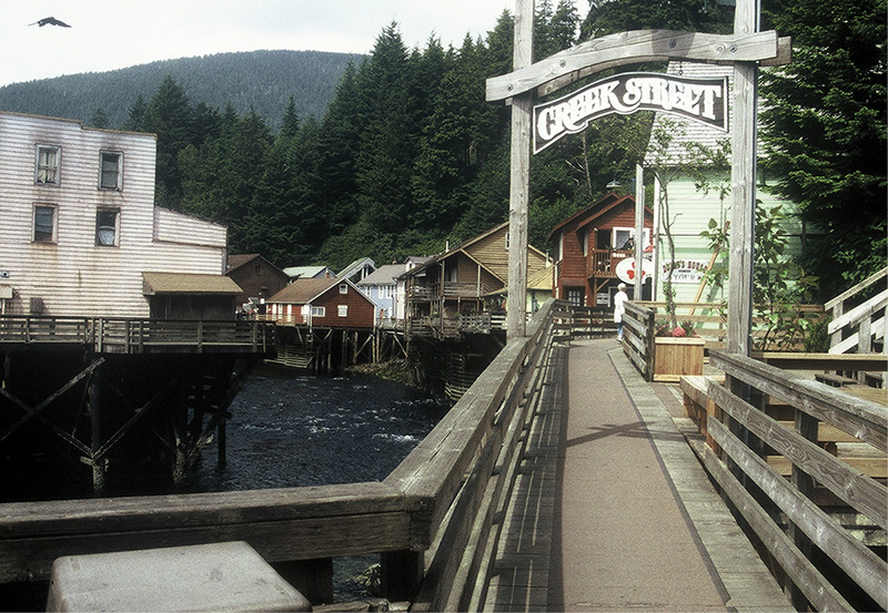
creek street, ketchikan
Banana Belt: Ketchikan (mile 110/883) to Petersburg (mile 249/1,017)
The middle portion of the Panhandle section is 139 miles long. Locals refer to it as the Banana Belt for its high precipitation, unusually mild summer temperatures, and stable wind and sea conditions compared to farther north. No single body of water dominates; instead, the route exits Tongass Narrows to Clarence Strait, thence into Ernest Sound, Zimovia Strait, Dry Strait, and finally Frederick Sound. Three communities are visited: Meyers Chuck, Wrangell, and Petersburg. The entire course is well protected, and tidal currents are not much of a concern. The 5-mile crossing of Behm Canal soon after Ketchikan is more tedium than hazard.
There are two route alternates. The first goes up the east side of Wrangell Island and visits the Anan Creek Bear Observatory. It is 5 to 7 miles longer than the main route, which courses up the west side of Wrangell Island. After Wrangell, the second alternate route diverges and goes up Wrangell Narrows, the main Inside Passage traffic route. This one is 11 miles longer than the main route, which hugs the mainland coast going directly north, across the Stikine River delta.
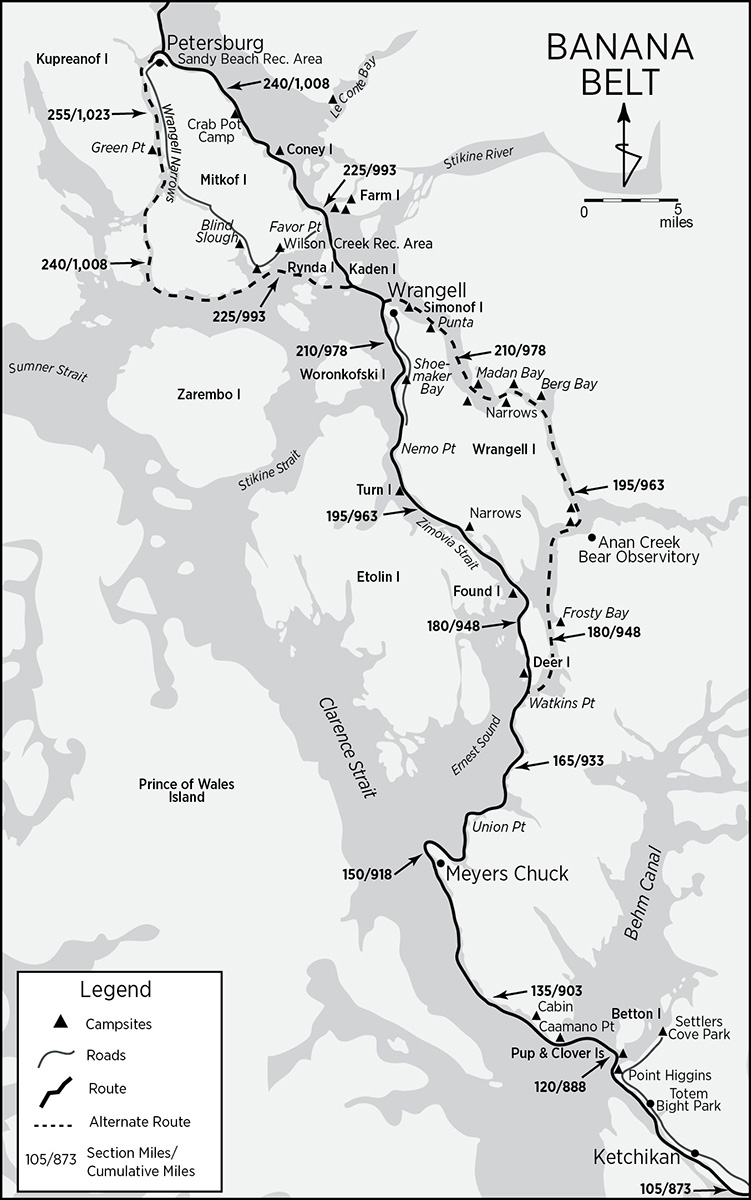
Shallow deltaic flats requiring precise tide timing (and probably some dragging) are the only obstacles. Each alternate will be described immediately following their points of convergence with the main route.
The leaving of Ketchikan is a drawn-out affair. Past Thomas Basin and Pennock Island, Tongass Narrows squeezes down to its narrowest point. The airport and industrial development line the shores. A small bight, Port Gravina, indents the coast near the north end of the airport runway. Now a ghost town, in the 1890s Port Gravina was a small town centered around a sawmill. A group of Tsimshians from Metlakatla who had attended the Sitka Industrial Training School started the settlement and sawmill in 1892. It was the first business to be capitalized, built, managed, and operated entirely by Alaskan Indians. Port Gravina burned to the ground in 1904 during a Fourth of July celebration and was never rebuilt.
Past Lewis Point (on Gravina Island) and Peninsula Point (on Revillagigedo Island), Tongass Narrows opens up. Pass by Ward Cove, site of Ketchikan Pulp Company’s giant pulp mill and booming grounds and the mouth of one of Revillagigedo Island’s major drainage valleys. Just beyond lie a group of islands protecting Refuge Cove, site of a marina with some supplies.
Totem Bight State Historic Park: Just before Mud Bay, emerging from the mists, two tall totems mark Totem Bight. Don’t miss it. The park is a curious combination of landscaped, manicured lawns and gardens with an elaborately decorated clan house and totems. The site, next to a salmon stream, was a Tlingit summer campsite. The Civilian Conservation Corps, working with master native carvers, completed the park in 1941. Though there is no camping, shelter from the rain is available, and a gift shop/snack bar combo is located where the road meets the park.
Point Higgins: Point Higgins (119/887), not much more than a rounded change in the coast’s direction, is the northwest corner of Revillagigedo Island. A black gravel beach leads to a number of tent sites cleared in the forest. The 1869 Coast Pilot reports the native village of “Tilhnach” on or near the point. The point’s name is illustrative of one of Vancouver’s charting procedures. Vancouver did not know Ambrose Higgins of Ballengh, Ireland, at the time he passed the point. On his way home to England, he stopped in Valparaiso, Chile, where he met Higgins, by then governor and captain general of Chile, who proved amicable and hospitable. This indicates that a good many of the places Vancouver charted were christened sometime after the survey, probably during the final preparation of the charts.

longhouse at totem bight
How does an Irishman become governor of a Spanish province? Higgins immigrated to South America, joined the Spanish army at a young age, and changed his name (actually boldly transliterated it and added an O) to Ambrosio O’Higgins de Vallenar. He performed well and worked his way up to the rank of captain of cavalry, after which he was titled a marquis before being appointed governor. In 1796, he was promoted to Viceroy of Peru until his death in 1801. Higgins is notable for fathering (illegitimately) Bernardo O’Higgins, war of independence liberator and first president of the Republic of Chile. Vallenar Point, Gravina Island’s northern and corresponding terminus of Tongass Narrows, also honors Higgins, as the transliterated version of Ballengh.
Round Point Higgins to Survey Point in preparation for the 5-mile crossing of Behm Canal’s western entrance. Just around the corner from Survey Point, the Clover Pass Resort and Knudson Cove Marina operate a variety of services. The closest developed campground is Settlers Cove State Recreation Site, about 5 miles up Clover Passage on the Revillagigedo side of the channel. Pup and Clover islands (mile 122/888), at the start of the Behm Canal crossing, may offer camping opportunities. Clover has the ruins of a structure, while Pup was homesteaded and patented in the 1930s. Modern maps of the Tongass National Forest indicate both as public land.
Clarence Strait: Caamano Point, the target on the other side of Behm Canal, marks the southern extremity of the mainland’s Cleveland Peninsula and this route’s junction with Clarence Strait. Clarence Strait is big. More than a hundred miles long and relatively wide, it separates Prince of Wales Island from the rest of the archipelago. However, strong currents and nasty seas do not bedevil it—at least from a kayaker’s point of view. Out in the middle, spring tides can attain 4 knots; summertime seas tend to be calm. Vancouver named the strait after the King of England. You don’t remember a King Clarence? He was born William Henry, third son of George III, who was king during the American Revolution. (For a more sympathetic portrayal of this tragic sovereign’s life, check out the excellent, award-winning movie The Madness of King George with Nigel Hawthorne.) William Henry held the title Duke of Clarence. Serving in the Royal Navy at that time, he was nearly captured by Washington’s forces. George III was succeeded by his elder son, George IV, who died in 1830. Clarence followed him as William IV for a scant seven years. Queen Victoria then ascended the throne for a long and stable reign.
Prince of Wales Island: While he was at it, Vancouver named Prince of Wales Island after the eldest son of George III. Prince of Wales is the largest island in Southeast Alaska and the second-largest island in the state, after Kodiak. Human bones close to 10,000 years old have been discovered here. The island is geologically unique in that much of its bedrock is porous limestone, otherwise rare in southeastern Alaska. The limestone drains well, creating ideal conditions for tree growth, particularly for Sitka spruces in low-lying river valleys. Consequently, some of the biggest spruce trees along Inside grew on Prince of Wales. There are a few still left, measuring more than 6 feet across and 200 feet tall. Otherwise, most of the island was extensively logged prior to 1990, with the exception of a cosmetic seashore fringe.
The bight on the Clarence Strait side of Caamano Point (126/894) is the site of southeastern Alaska’s only (abandoned) antimony mine. The claims are held, but undeveloped, by the Duval Corporation of Tucson, Arizona. Denis Dwyer reports a level forest camp on an unnamed island northeast of the point.
Up from Caamano Point, the shore trends in a northwesterly direction, with few landmarks for a good 20 miles. Many tiny inlets, none discernible on the 1:250,000 scale topo map, indent the coast. One (about mile 130/898), not clearly visible from the water, has a double bight with a shingle beach and private cabin in the woods. It is an excellent campsite in an area not particularly devoid of them. Keep a lookout between the minor points labeled Jay and Pen prior to Niblack Point.
Meyers Chuck: Meyers Chuck (mile 149/917) is a tiny, old, terminally cute, and fortuitously located settlement and harbor. The name is one of the few remaining examples of Chinook, a trade language (like Swahili) developed by Northwest Coast natives and white traders to facilitate commerce between the two cultures and among the different native language groups. A chuck is a saltwater body that dries at low tide. Other Chinook jargon geographic names include tatoosh (breast), chickamin (metal or mineral), and skookum (strong; combined with chuck, as in Skookum Chuck, renders the word for tidal rapids). By the late 1800s, white settlers began living year-round at Meyers Chuck. The town developed around fishing and, by 1922, soon after nearby Union Bay Cannery opened, it boasted a post office, general store, machine shop, barber shop, bakery, and bar. By 1939, 107 residents lived in Meyers Chuck.
The 1940s decimated the Chuck’s population. Many residents left to join the armed forces or wartime production in the Lower 48. Declining salmon stocks made fishing less profitable. When the Union Bay Cannery burned down in 1947 and no one attempted to rebuild it, jobs disappeared. Atop all this, land titles were in legal limbo. When the land was finally patented between 1965 and 1969 and the community was withdrawn from the Tongass National Forest, Meyers Chuck stabilized—for a while. A state-of-the-art school was built in 1983. However, two major fires that year consumed much of the town and the enthusiasm of the Chuckers. The school is no longer staffed. A state land-disposal sale was offered in 1986 but did not precipitate a land rush. A new air float and docking facility graces the harbor and immeasurably improves the community’s infrastructure. Still, the present population hovers at 37. There has recently been talk of combining Meyers Chuck in the same borough with Hyder, but, due to conflicting visions, residents are reticent.

meyers chuck
Enter Meyers Chuck through the foul passage just south of Meyers Island, dock at the new pier, and inquire from the locals as to the lay of the land. Though there is no handy camping in the village, ask a resident where to discretely pitch your tent. The floatplane dock or helicopter pad up on the new metal wharf have been offered in the past. One absolutely incongruous public telephone—complete with urban-style phone booth—stands at the head of the dock trail next to the community bulletin board. The post office is open on Tuesday from 11 AM to 2 PM and on Wednesday for one hour after the mail plane arrives. One attractive restaurant is open whenever demand and the whims of the owners coincide. A small art gallery operates on and off.
Beyond Meyers Chuck, turn at Lemesurier Point and enter Ernest Sound. The ruins of the Union Bay Cannery mark the middle of Union Bay’s east shore. There may be camping in Union Bay, though we did not explore. Currents in Ernest Sound flood and ebb at about 2 knots. The Ernest Sound route is the most popular cruising course between Ketchikan and Wrangell.
Cross Union Bay to Union Point, flanked by Magnetic Cove on the south, and Vixen Harbor on the north. Both inlets may have possible campsites. Cross Vixen Inlet to Vixen Point and continue up the coast, passing Emerald Bay and Eaton Point to Watkins Point.
At Watkins Point, this section’s first alternate route diverges from the main route. While the primary route crosses due north to Deer Island and then goes up Wrangell Island’s west side, through Zimovia Strait, the alternate follows a series of channels and passages up Wrangell’s east side. The alternate route is described immediately following the main route’s arrival at Wrangell.
From Watkins Point, cross Seward Passage to Point Peters (mile 175/943) on the southern tip of Deer Island. Just around the west side of the point, a very attractive and tree-clear high bench beckons as a potential campsite. Deer Island is Kwakiutl land; permission is required to camp here (as per the posted sign with a phone number). Our own experience, however, was disturbing. Checking out the campsite, we were astounded at the abundance of bear scat. Every 5 to 6 feet, in every direction, lay fresh, huge piles of black excrement. Very disappointed, we headed for the small islands off the west side of the point, where we found an adequate campsite. Wherever you choose to camp, be aware that the Anan Creek bear observatory is nearby, and this entire area has a very high and concentrated bear population. (As of 2004, a seasonal youth camp has been established on Deer Island.)
Make your way up the west side of Deer Island through the intriguing archipelago just offshore Deer’s northern tip. Cross over to Found Island.
Found Island: In 1923 Found Island (mile 183/951) was home to a fox farm operated by Louis Scribner. It is one of a select type of island—smallish, topographically accessible, somewhat isolated from other landmasses—that flourished as fox farms during the 1920s and is the first of many encountered along this route. Enterprising Russians, aware of diminishing trap line returns, probably started the practice. According to historian Patricia Roppel:
Island fox farming developed in the Aleutian Islands and spread to most suitable islands in Southeastern Alaska by the early 1920s. A man, a married couple, or a syndicate which hired a watchman would apply to the USFS for a lease on a specific island. By 1923 over 150 island leases were issued in the Tongass National Forest. The farmer built a cabin to live in, a shed for his gear and feed, feeding troughs, and sometimes pens, and then imported pairs of blue foxes. Live foxes were purchased from farmers in the Interior of Alaska, and as farms became established, from other Southeastern Alaska fox farms. In 1922, a pair of breeding blue foxes cost between $350 to $400, and litters averaged from six to nine kits. It took about three years before the fur could be harvested . . . a blue fox pelt sold in Tacoma for $166.50.
Fox farmers believed that using small islands and stocking them to capacity, and hiring reliable caretakers to cover every portion of the daily needs gave the best results. . . . A great deal of experimentation with different foods, housing, breeding, and marketing pelts took place. Fox farmers tended to feed salmon and other fish, fish offal from the canneries, seals, grains and meals, and anything handy. Manufacturers of prepared feed had just started researching proper diets. In later years a more scientific diet improved survival rates.
By the time Dr. E. F. Graves, Territorial veterinarian, evaluated the success of fox farms in Alaska in 1928, he found many fox farmers had failed. Large losses occurred from internal and external parasites, faulty breeding, digestive disturbances, killing by wolves and eagles, and poaching. . . . Graves thought the average island-run ranch was conducted by methods which were wasteful and extravagant and run by people totally unsuited to their task of handling and raising foxes.
One Fish & Wildlife officer, during Southeast’s fox farming heyday, commented that “the only fox men that were going to make money were those who could double the capacity of their stills.” By 1932, the Great Depression reduced pelt prices to about $10, bankrupting most farmers. Few farms remained by the 1940s. Fox farm islands nearly always afford a camping opportunity.
Enter Zimovia Strait, separating Wrangell Island from Etolin Island. Tidal currents running at about 1.5 knots enter and exit the strait from both the north and south ends and meet near the Village Islands.
Thoms Place, a cove on the Wrangell side of the channel, is an undeveloped park. A creek flows into drying flats at its head.
The Narrows: Beyond Thoms Place, enter The Narrows of Zimovia Strait, a particularly attractive area. Much of The Narrows all the way to the Village Islands is the site of an abandoned Tlingit village, whose center was on the point due east of the more southern of the two main Village Islands. You can still see signs of cleared landing places on the beaches for the big canoes. The village was called Kots-lit-na (“Willow Town”), though it is sometimes referred to as “Old Wrangell.” The Narrows is the last dependable at-large camping prior to Wrangell, still 20 or so miles north of the last Village Island. The first likely camp, on Wrangell Island, is due east of the Zimovia Islets (mile 191/959), where the topo map indicates a couple of cabins. According to the local Wrangell Guide, one of the cabins is a state-owned public recreation site. Other likely campsites dot The Narrows/Village Islands area, including—according to Denis Dwyer—Turn Island (197/965).
Round Nemo Point. Four miles farther up the Wrangell Island coast, the Petersburg, Alaska-Canada USGS 1:250,000 topo map indicates a campground at the end of the Wrangell highway. This campground no longer exists. A small offshore island just before and another just opposite the nonexistent campground will accommodate a tent or two in a pinch.
North of Chichagof Peak, Shoemaker Bay (208/976) gives the first indication of approaching Wrangell. Pass a conspicuously flat, cleared area where the impressive buildings of the Wrangell Institute, a boarding school for native children built in the 1930s, used to contrast elegantly with the green fields of the grounds. The school was closed in 1987 due to the use of asbestos during construction and was demolished in 2001. Though part of the bay is used to store log booms, Shoemaker Bay accommodates a boat harbor and some services for sportfishing boats. There is an RV and tent campground with adjacent 3.5-mile-long Rainbow Falls/Institute Creek Trail. The Shoemaker Bay RV Park is about 5 miles from Wrangell. Kayaker Susan Conrad reports (2016) an amenity-laden public campground just a mile south of the town, well within walking distance.
Wrangell: Cruise on by Wrangell Harbor and continue to the city dock (also known as the cruise ship dock, though big cruise ships don’t often stop at Wrangell) or the ferry terminal, both at least another 0.5 mile on, depending on your destination and plans. Wrangell Harbor is crowded and not particularly centrally located. The uncrowded city dock offers out-of-the-way kayak parking, particularly under the pier. There is no parking at the ferry dock (a tad farther), but Fennimore’s Trading Post B&B is immediately adjacent.
Although there is no handy public campground for kayakers inside Wrangell, a variety of lodging options are relatively close at hand. Right at the top of the city dock, the Stikine Inn, charging about $183 (as of 2018), is the handiest alternative. About two blocks away to the south, at 225 Front Street, next door to the Diamond C Café, is the Diamond C Hotel and Laundra-mat. The Thunderbird runs about $75 for two. At $18 per person, the thriftiest alternative is the Wrangell Hostel in the First Presbyterian Church, up the hill at 220 Church Street. Couples’ rooms are available, though bath, toilets, and a great kitchen are shared.
There are a half-dozen B&Bs; all will provide transportation. I’ll only mention Fennimore’s because of its location right next to the ferry terminal. Two giant breakwaters on the north side of the terminal create a square beach that makes for a suitable landing. It runs about $70 for two.
City Market is located on Front Street, about a block south of the Thunderbird Hotel, while Bob’s IGA Supermarket is virtually outside the Diamond C’s back door. Both sell liquor.
Wrangell, with a population of only 2,500, is the smallest major city along Alaska’s Panhandle. It does not owe its existence to logging, mining, fishing, or tourism but rather to its strategic location at the mouth of the Stikine River, a major artery connecting interior BC with the coastal archipelago. Old Wrangell, the Tlingit village in The Narrows, gained importance and reputation when Gush-klin, chief of the Stikine Tlingits, decisively defeated We-Shakes, a Nisga’a chief, after a long-running contest for hegemony over the region. As a token of respect and submission, the Nisga’a chief conferred the prestigious title of We-Shakes, meaning “splash of a killer whale’s fluke,” on Gush-klin. It was the beginning of a powerful dynasty that lasted until 1944, at the death of Chief Shakes VII.

During the late 1700s, when European explorers and traders began visiting the area, Chief Shakes could see the handwriting on the wall. So he established a village at the site of present-day Wrangell (on Shustaak Point and Shakes Island) to better control trade with the interior tribes. By 1811, the Stikine Tlingits were conducting a profitable beaver and otter pelt trade with the Russians. Meanwhile, the Hudson’s Bay Company, expanding ever westward, was eyeing the Stikine River delta as a possible outpost site to coordinate trade with the interior. When the Russians got wind of the plan, they dispatched Captain-Lieutenant Dionysi Zarembo in 1833 to preempt the British by building their own fort at the delta. Stephen Hilson relates:
When the Russians first arrived at the harbor presently called Wrangell, they met a family . . . (who) was pursuing their summer fishing activities. The Russians made it known to the head of the family that they wanted to speak to the local chief (Shakes IV) and sent the Indian to Old Wrangell to get the leader. When the fisherman paddled into Old Wrangell he gave a whoop to announce big news. He told Shakes IV that the Russian ship was anchored near his fish camp and the commander expected Chief Shakes to paddle up there for a meeting. The chief instructed his man to return to the Russian and inform him that since he was certainly no more important than the chief, he would have to come down to Old Wrangell to conduct his discussions.
Some time later the Indian paddled back to Old Wrangell to tell Shakes that the Russian claimed he could not sail his ships down the narrow and uncharted Zimovia Strait, therefore the chief must come to him.
Undaunted, Shakes sent 200 canoes to the Russian and towed him (and his ship) to Old Wrangell where the conference regarding the construction of the fort was held.
In 1834, the Russian fort at Wrangell was christened Redoubt St. Dionysius and soon intercepted the first Hudson’s Bay Company trading expedition. The ensuing crisis was settled by Shakes, who reminded both parties that the Stikine Tlingits controlled interior trade with the Athabaskans, not the Russians or British. The British withdrew.
But the Russians weren’t really interested in expanding their empire (after all, they were already overextended), only in keeping the British from expanding theirs. Once the British submitted to Russian jurisdiction at the Stikine delta, the Russians offered to lease the new settlement to the Hudson’s Bay Company for 2,000 otter pelts annually, plus a quantity of wheat and salt beef. In 1840, Redoubt St. Dionysius became Fort Stikine. In spite of the booming commerce with the natives, the British abandoned Fort Stikine in 1849, and the settlement languished until the 1861 Stikine gold strike, when a minor boom revived the town.
In 1867, when the United States purchased Alaska, the US Army took control of Fort Stikine, built a new fort, and named it Fort Wrangell, after Baron Ferdinand Wrangell, last manager of the Russian-American Company. Wrangell briefly ballooned to 15,000 (albeit temporary) residents during the Cassiar gold rush in interior BC, when it was used as the gateway to the goldfields up the Stikine. The settlement was almost abandoned after the Cassiar rush ended. In 1888 the US Army transferred the reins of government to a civilian US commissioner and abandoned Fort Wrangell. When steamers transporting the 1898 Klondikers used Wrangell as a stopover, the town revived and then grew slowly around fishing and logging.
Wrangell is small enough that you can walk to all the major attractions. The old downtown—what is left of it after two major fires—proudly preserves many old wooden false-fronted buildings. The harbor berths an extremely active fishing fleet. Right in the middle of it is Shakes Island with Chief Shake’s tribal house and totems. The entire compound was built by the Civilian Conservation Corps in 1939 and 1940, with direction from the Stikine Tlingit, and is meant to be a faithful reproduction of the original work. More than 1,500 mostly native visitors conducted the last great potlatch of the local Tlingit people at its dedication in 1940. The event was crowned by the investiture of Chief Shakes VII, last of the Shakes chiefs. (Shakes VI died in 1916.) If the clan house is closed, call 904-874-3747 for a tour. A donation is requested for admission.
For a good leg workout and stunning views of the town and surrounding seascape, hike the improved trail up Mount Dewey, between Wrangell and the airport. Petroglyph Beach, a 15-minute walk north of the ferry terminal or city dock on Evergreen Avenue, lies below the high-tide line at the end of a signed trail and wooden boardwalk. Lastly, if you arrived at Wrangell via the main route, you will have missed the Anan Creek Bear Observatory (described along the alternate route, immediately following), about 30 miles south of Wrangell on the mainland. Many local outfitters (see Appendix B for a handful) offer day and overnight tours to the observatory or up the Stikine River.
Alternate Route #1: Watkins Point (near southern tip of Deer Island; mile 175/943) to Point Highfield (mile 215/983) via the east coast of Wrangell Island
The Seward Passage/Blake Channel/Eastern Passage alternate route is 5 to 7 miles longer than the main route and includes the Anan Creek Bear Observatory. (Backtracking south to Wrangell is an additional 2 miles, hence the 7 miles.) Many consider it the more scenic of the two choices. South of The Narrows, vertical cliffs line the shores for much of its length.
From Watkins Point, follow the mainland coast past Sunny Bay and Point Santa Anna. Santa Anna Inlet has a quarter-mile-long creek at its head flowing out of Lake Helen. USGS topo maps indicate a cabin there, so camping ought to be possible. There is a 3-mile overland trail across the Cleveland Peninsula to Yes Bay in Behm Canal. Five miles farther up Seward Passage lies scenic Frosty Bay (mile 182/950). About half as deep as Santa Anna Inlet, Frosty Bay’s mouth is protected by a resident colony of seals off its west entrance. According to the Douglasses: “A logger’s cabin on the southwest shore near the log transfer site has been renovated by the USFS for use as a recreational cabin,” so, one way or another, there’s probably a spot to spread a sleeping bag.
Continue north to the top of Ernest Sound. The entire Cleveland Peninsula shore from Frosty Bay to Anan Creek is precipitous but for one notable exception. In a small bight just below Point Warde stand the few remains of an abandoned cannery, another possible campsite. At the junction of Ernest Sound, Bradfield Canal, and Blake Channel (mile 192/960), Anan Bay indents the Cleveland Peninsula’s northwest corner while, directly opposite, a beautiful campsite graces the southeast tip of Wrangell Island: a perfect base for a visit to the Anan Creek Wildlife Observatory.
Anan Creek Wildlife Observatory: Until 2004, access to the observatory was lightly regulated. Due to phenomenally increased demand, the US Forest Service established a permit system in that year to regulate the number of visitors at any one time. Permits are for a specific date and must be obtained in advance from the Tongass National Forest, Wrangell Ranger District, P.O. Box 51, Wrangell, AK 99929; phone 907-874-2323. For an Inside Passage kayaker who may not be able to plan his arrival precisely, this could prove daunting. However, the ranger in charge has assured me that he’ll make every available effort to accommodate visiting through-kayakers.
Failing that, there is always the more conventional approach: an outfitter. Most folks visit the observatory guided by an outfitter from Wrangell at a cost of about $200. The day trip consists of a prior or even last-minute arrangement through an outfitter’s kiosk at the Wrangell City Dock. The 90-minute jet boat shuttle is comfortable, includes an orientation, and provides 4 to 6 hours of viewing at the observatory. Breakaway Adventures offers a bare-bones trip for $150 and guarantees a bear sighting (during July and August) or your money back.
During July and August, the waterfalls of Anan Creek abound with salmon, drawing bears, eagles, and seals. There are some 40 to 60 black bears and 15 to 20 brown bears in the area. The Forest Service has built a roofed observatory overlooking the falls half a mile from the bay and accessible via a planked boardwalk. Regulations require that you stay on the boardwalk and carry no food. While on the boardwalk, talk loudly or make noise to broadcast your presence. Bear repellent, to deter the overly curious, is not a bad idea.
Why does Anan Creek, not a large drainage, attract so many bears? Let’s look at it from the perspective of a salmon and its hunters. The configuration of the last mile of the stream is peculiarly unique. The mouth of the creek is constricted by a Gibraltar-like set of tall, narrow rock gates, behind which is a broad, shallow tidal flat—a natural weir that traps fish during tidal fluctuations. A couple of hundred yards upstream of the lagoon, the creek narrows down at a declivity above a series of small pools, where the fish must regroup and reconsider their strategy. The falls are not easy. It is here that they are most vulnerable to bear predation, and it is here where the decks and blinds of the observatory have been elegantly constructed.

mouth of anan creek
Bears are not the only predators to have taken advantage of Anan Creek’s unique topography. Bifurcating the tidal lagoon is a broad, flat, round peninsula—a perfect location for a Tlingit summer village. Their use was so intense—and ancient—that the spit remains their property. Even small children could wander out into the muddy flats and collect salmon by hand. Myriad drying racks with strips of phosphorescent flesh, like pennants at a used car lot, must have highlighted all the activity. When white men arrived, the inevitable cannery was built on the site. By the early 1900s, the salmon had nearly disappeared. Today, there is no sign left of the incursion, though the fish have come back with a vengeance.
Dances with Bears V
The photographers’ blind at Anan Creek is limited to five observers for half an hour. There is a sign-up sheet on the upper decks. I thought I was prepared: five rolls of ASA 200 slide film—36 exposures each—and a 160mm telephoto lens. I crouched on a tiny stool behind a slit opening. In less than half an hour a fat black bear waddled down to the upper pool, quickly scanned the situation, and snatched a big salmon with a slice of the paw and a snatch of his jaw. He paused on his perch, the flopping of the fish forcing his head to wobble comically from side to side, like a bobble-head doll, obviously pleased with himself. Out of the forest, a big old black sow casually approached the pool, ignoring the rotting remains of five salmon carcasses. Clearly, like a corpulent Roman at an orgy, she was forcing herself to eat. From another quadrant, a diffident youngster cautiously surveyed the scene and waited for an opportunity to approach a pool.
As of yet I hadn’t taken one shot. Conditions—the deep forest, overcast skies, long lens, not-fast-enough film and, surprisingly, light-sucking black fur—conspired to render my attempts useless. I despaired.
Suddenly, a murmur alerted me. From downstream, a self-conscious, nonchalant, big, blond brown bear with an oversized head zigzagged his way up. Every black bear froze in his tracks and watched the brown’s every move. He stopped about 50 yards away to inspect a floater—an old, dead salmon. After a nibble or two, he climbed on a rock and set out to cast his paw. What a treat! Now we’ll see a true virtuoso at the top of his game, we thought. But try as he might, he was unable to land even one fish. Instead, this blond turned out to be totally inept. Still, his impressive presence intimidated the other bears and, lucky for me, his light blond fur reflected plenty of light for a few good shots.
From the observatory, aim north for Blake Island at the mouth of Blake Channel. Floods run north, and ebbs run south, both with a velocity of 2 to 3 knots. Blake is narrow, cliff-lined, and moderately swift of current, so plan to go with the flow. Two-thirds of the way up the west side of Blake Island, a small bay (mile 194/962) breaks the shoreline; a good campsite if the one nearest Anan is occupied. Berg Bay (mile 202/970), named after the Berg Mine and the abandoned community of Berg (not the presence of icebergs) has a Forest Service cabin at its head with a USFS float. Camping is possible in this stunning alpine setting, where permanent snowfields grace the 5,000- to 6,000-foot peaks less than 10 miles to the north.
Blake Channel then turns northwest and sharply constricts at the Narrows (not to be confused with The Narrows, on the west side of Wrangell Island), a 250-yard-wide, 1.5-mile-long mini-channel that bends a further 90° to the southwest. There are at least two campsites each along both the Wrangell Island shore and on outlying islands along the mainland shore through this stretch. In spite of its narrowness, the Narrows do not present a current obstacle. Tidal flows around Wrangell Island enter and exit from the island’s extremities and meet at the Narrows where currents tread water. Eastern Passage—where the shore’s steepness eases considerably—leads from the Narrows to the top of Wrangell Island. Being much wider, Eastern Passage’s tidal flows attain only a 1.8-knot velocity. The passage floods south and ebbs north.
At the end of the Narrows, on the extreme southeast tip of Madan Bay (207/975), there are more campsites. Additionally, across the channel in the crotch below Channel Island, at the terminus of an old logging road (and where the 1:250,000 map indicates a cabin), there is another good campsite. Pass Channel Island and Point Madan en route to Wrangell Island’s northern tip. Halfway up, just below the “Punta” triangle (mile 216/984) there is a campsite on the Wrangell Island shore. Just prior to Point Highfield, Wrangell’s busy airport breaks the quiet. Directly offshore, Simonof Island (mile 221/989) provides the last camp before Wrangell. Round Point Highfield and rejoin the main route. Wrangell lies about 1 mile south.
Main Route: Continued . . .
The leaving of Wrangell confronts the paddler with the whole reason for the town’s existence: the delta of the mighty Stikine River. Its broad sedimentary fan extends 20 miles north from Wrangell. From the Stikine’s mouth it reaches west about 15 miles out, nearly grabbing Mitkof Island’s toe and almost making it part of the mainland. Unlike other major river deltas along the Inside Passage, the Stikine delta is quite negotiable by kayak. The route through it, Dry Strait, is protected, relatively short, and—because it traverses the delta’s outside verge—hardly subject to the brunt of the river’s current. The main obstacles are drying mud flats and tidal currents. Most cruising, ferry, and commercial traffic avoids the delta entirely, traversing the well-maintained, albeit narrow, Wrangell Narrows as the preferred route to Petersburg. Although 11 miles longer, this second alternate route will be described immediately following the main route’s arrival at Petersburg.
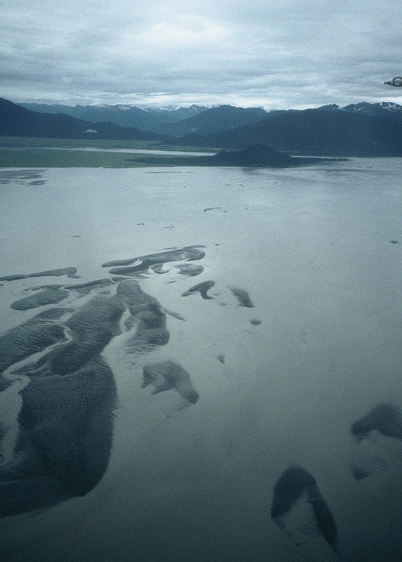
dry strait
Dry Strait: Traversing the delta’s 20-mile breadth requires about a six-hour paddle coupled with a route and timing strategy. Dry Strait mostly dries at or near low water. Tidal currents up Sumner Strait can attain 2 knots. Where they meet and oppose the river’s flow, they weaken considerably. Ebbs, when both river and tide flow in the same direction, can attain 5 knots around Blaquiere Point. Passage north should be attempted on the upper half of a rising tide, or three to four hours from Wrangell before high tide. With this strategy, high tide should find you somewhere in the middle of Dry Strait with plenty of water underthwarts and ready to meet and ride Frederick Sound’s ebbing tide north. According to the Coast Pilot, Dry Strait is “extensively used by fishing boats and towboats.” We saw no one.
With sufficient water, any compass course from Wrangell to Dry Strait is theoretically possible, especially for a kayak. There is, however, a preferred transit channel for craft with any draft and it is this channel that is here described. From Wrangell, head for the south shore of Kadin Island. Then make your way to Rynda Island. About halfway up its east coast the high-water boat passage through Dry Strait commences. Aim for Blaquiere Point (a.k.a. Favor Point) and hug the Mitkof Island shore. There is an old boat ramp just past the point. On the opposite shore, in the marshes at the western tip of Farm Island (mile 225/993), are three USFS recreational cabins, where camping may be possible. But beware: the Dry Strait area is notoriously buggy. If for some unfortunate reason you run aground, get out, line the boat, and persevere. Adequate depth is just a few yards away. Once past Dry Island—and the navigational light just opposite on Mitkof—the permanent water of Frederick Sound begins.
For the next 60 miles, wide Frederick Sound will be our highway north. Currents can reach 1.5 to 2 knots. Pass Cosmos Point and Ideal Cove. Much of Mitkof Island’s east coast is low-lying, with many possible campsites. Notable is steep-to Coney Island (mile 232/1,000), an old fox farm site, and so-called Crab Pot (237/1,005) 22 miles from Wrangell on the east coast of Mitkof Island. Immediately opposite on the mainland shore and guarded by the Stikine delta’s mud flats lies Le Conte Bay.
Le Conte Bay: Deep within Le Conte Bay (mile 232/1,000), North America’s southernmost tidewater glacier descends from the mountains into the sea. The Le Conte Glacier calves a constant parade of icebergs that usually line Frederick Sound’s north shore below the Horn Cliffs. From a distance some look like luxury yachts. Sometimes they reach Petersburg. At this point Frederick Sound is 6 miles wide, putting the bay that many miles off-route, while the glacier itself is another 10 miles inside the bay. Further impeding access, the Stikine delta’s northern edge obstructs the entrance to the bay. For some, however, a visit to this frigid kingdom and notable landmark is irresistible. This is remote and rugged country. Cruising boats seldom enter due to the multiple obstacles of icebergs, tidal flats, and rocky shoals.
If you decide to visit, head due north from Coney Island toward the mainland, skirting the mud flats of the Stikine delta. Just past Camp Island, turn east for Indian Point and Le Conte Bay’s entrance. Air temperature noticeably drops. There are numerous campsites around Indian Point. Within the bay, shores steepen, so choose a campsite at or prior to Thunder Point.
The Le Conte Glacier’s mile-wide face is very active. Some 2,000 harbor seals live in the bay and rear their pups on the bergs. Do not approach nurseries. Be aware that since icebergs float with two-thirds of their mass below waterline, they can unexpectedly flip as they melt. Do not approach the face of a tidewater glacier too closely; bergs can calve at any time. Not that one of these spalls is likely to land right on a kayak. The real danger lies in the percussion wave—sometimes unexpectedly large—that can swamp or flip nearby small craft.
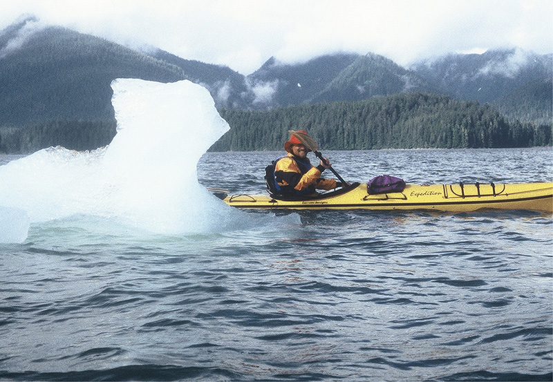
le conte iceberg
From Coney Island, 15 mostly uneventful miles remain to Petersburg. Camping is not particularly scarce. Around Frederick Point, the shore becomes rocky and steep. A small bight about a mile before the northern tip of Mitkof Island shelters Sandy Beach Recreation Area at the northern end of Mitkof Highway and still about 2 miles from downtown Petersburg. Sandy Beach used to host camping and still looks like it might. However, as of 2005, it did not.
Petersburg: Petersburg is small (population 3,300) but very busy—it is the homeport of more than 300 commercial fishing boats—with a small harbor. Lodging is often full and dear. The only available campsite is the Le Conte RV Park on Fourth and Haugen Drive, downtown but about five blocks from the docks. Just south of town and adjacent to the ferry dock is the Waterfront Bed and Breakfast, within walking distance of downtown and with handy exit and launch next door at the dry dock (ask permission) or a bit farther east at a public boat ramp. The Waterfront is kayak friendly and charges $110.

Paddling into Petersburg harbor is a fine experience. Continue up to the tip of Mitkof Island and enter the north end of Wrangell Narrows. If the tide is contrary—and it can be strong within the narrows—hug the shore; it’s only 1 mile or so to the very busy harbor. Medium-sized vessels of every sort are continuously coming and going and vying for berthing space. Exactly where to head for? If equipped with VHF, call the harbormaster on Channel 16 at least 30 minutes before your arrival, then switch to Channel 9 to receive a mooring assignment. With the kayaks safely berthed, you can seek accommodation at the Le Conte RV Park or upgrade to one of the many hotels or B&Bs in town. The Scandia House, running $90–175, is only about a block and a half from North or Middle Harbor at 110 North Nordic Drive. All services are available within short walking distances in this tidy town, including a kayaking outfitter, Tongass Kayak Adventures. Call them at 1-800-722-5006.
Petersburg, in spite of its seemingly Russian name, was founded in 1891 by Peter Buschman, a Norwegian emigrant, and named after him. Buschman built a salmon cannery and sawmill and laid out the town’s neat grid. Other Norwegians soon followed and developed a well-planned Scandinavian-style community. Petersburg still honors and celebrates its Norwegian heritage on May 17 (Norwegian Independence Day) during the Little Norway Festival. What set Petersburg apart from other Southeast towns was the nearby location of Le Conte Glacier’s ice. Although the salmon cannery was successful, the endless source of ice allowed Petersburg to become the halibut capital of Alaska. Packed in glacier ice, the delicate and flaky fine white fish was shipped by steamer to Seattle and forwarded to eager East Coast markets.
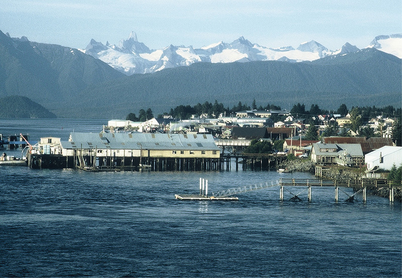
petersburg
The town remains the major fish-processing community in the Panhandle. Petersburg Fisheries, Buschman’s old company, is now a subsidiary of Icicle Seafoods. Besides the salmon and halibut industries, Petersburg has diversified into crab, herring, prawns, and the delicate Petersburg shrimp, fished within a 25-mile radius of town.
On a clear day, Petersburg is framed by the ice fields and naked rock peaks of the Coast Range. Devil’s Thumb rises agonizingly close. Because it lacks a deepwater port, large cruise ships do not call at Petersburg. It is not a kitschy town. Walk south to Hammer’s Slough, where stilt houses and wood-planked streets line South Harbor. Next to the Sons of Norway Hall stands a bronze commemorative statue of a fisherman, mute reminder that fishing is serious business. Close by is Sing Lee Alley Books, one of the Inside Passage’s best bookstores.
Alternate Route #2: Wrangell (mile 213/981) to Petersburg (mile 249/1,017) via Wrangell Narrows
Note that the Wrangell-Petersburg distance via the main route is 36 miles, while along the alternate it is 47 miles, 11 miles longer than the main route. It entirely avoids the Stikine River delta and approaches Petersburg with the big boys up Wrangell Narrows. A navigationally challenging adventure for most craft, it is far less so for kayaks, which need only time their passage in concert with the tides.
From Wrangell, head toward the passage between Liesnoi and Kadin islands. Tidal currents flood Sumner Strait from the west at a maximum of 2 knots but diminish considerably where they meet the Stikine’s outflow. Ebb tides are much stronger. If you leave Wrangell at or near high tide, you can ride the ebb the full 26 miles to Point Alexander, entry to Wrangell Narrows. Instead of heading for the Dry Strait boat passage, stay south and west of the delta, skirting Greys Island round the south. Aim northwest for Wilson Island off Mitkof Island’s shore.
On Mitkof Island, a road from Petersburg follows the shore east of Blind Slough. Nearby the Wilson Creek Recreation Area (mile 225/993), near the Banana Point boat ramp, has good camping with picnic tables and an outhouse. Another 2 miles brings you to Blind Slough, one of twin sloughs that, with a connecting river valley and low depression, nearly cut Mitkof into two islands. Green Point (mile 227/995), the northeastern entrance to Blind Slough, has good camping. Ohmer Creek Campground, at the head of the slough, is well developed, with improved tent and RV sites, picnic tables, bathrooms, and drinking water. A small fee is required.
Wrangell Narrows: Wrangell Narrows separates Kupreanof and Woewodski islands from Mitkof Island. Vancouver found a nearly unnavigable slough. During the 1940s, enterprising locals dredged themselves a waterway with a controlling depth of 19 feet and a width of 300 feet. Still, the really big cruise ships don’t fit. Were it not for its existence, most Inside Passage vessels would have to go 200 miles around Kuiu Island and through Chatham Strait. According to the Coast Pilot:
Wrangell Narrows extends . . . for 21 miles. . . . The channel is narrow and intricate in places, between dangerous ledges and flats, and the tidal currents are strong. It is marked by an extensive system of lights, lighted ranges, daybeacons, and buoys. . . . Waterborne traffic through the Narrows consists of cruise ships, state ferries, barges, and freight boats carrying lumber products, petroleum products, fish and fish products, provisions, and general cargo.
The strongest currents occur off Turn Point and off Spike Rock and South Ledge Light. The velocity of the current at times of strength at these points is between 4 and 5 knots. During spring and tropic tides, velocities of 6 to 7 knots may occur.
The tides meet just south of Green Point between lights #44 and #48, 12 miles up from the south entrance and about 8 miles down from the north entrance. Plan on rounding Point Alexander and entering the Narrows on the last three hours of a flood tide so that high-water slack finds you at Green Point. Tidal changes at the southern end and center are about 20 minutes (or longer) behind Petersburg. Watch for rips that form off Point Alexander on the flood. You can then ride the 8 miles north to Petersburg on the ebb.
The Wrangell Narrows terrain is mostly shallow before the surface—hence the dredging—and continues low-lying inland beyond the shore. Keep an eye out for ferries and other heavy traffic whose wake can be disastrous in shallow water at close range. Terrain-wise, campsites are abundant, with cabin density increasing the closer one gets to Petersburg. Most of the upper Mitkof Island shore is, if not private, not part of the Tongass National Forest like the Kupreanof and Woewodski side. Camping is mostly tolerated; however, be sensitive and respect cabin sites, particularly in Keene Channel and near Petersburg.
Midway Rock marks the beginning of the Narrows and strong currents. At the junction with Beecher Pass, favor the Mitkof Island side as crosscurrents impinge. Pass Papkes Landing, a lumber company bulkhead pier, and wait for the ebb tide at Green Point. Scow Bay is the site of the Beachcomber Inn, a waterfront hotel and restaurant that occupies a former cannery. Local seafood is the specialty of the house. Another 3 increasingly developed miles remain until Petersburg. See the description of the main route for access, camping, and lodging at Petersburg.
Admiralty Island: Petersburg (mile 249/1,017) to Juneau (mile 382/1,150)
Admiralty Island, second largest in the Alexander Archipelago, and Frederick Sound/Stephens Passage, dauntingly broad and second to none in size and consequence, dominate the last third of the Alaska Panhandle section. Reaching the south bastion of Admiralty across the junction of the two waterways is the crux of this section, and many a paddler has paused thoughtfully with trepidation. Although the 15-mile distance is broken by island stops, the five-hour paddle is long enough for conditions to impose their own agenda. Some turn back in defeat. More than a few endure an unexpected spanking. Once committed, cross with perseverance, tenacity, and a willingness to reassess strategy as conditions evolve.
There are no human settlements along the route. On Admiralty, brown bears outnumber humans two to one, and there are more bald eagles than in all the other states combined. Still, the hand of man is artfully and hospitably evident along the entire route. Five Finger lighthouse, NFS cabins and shelters, the Pack Creek bear observatory tower, and the Oliver Inlet portage tramway are far from unwelcome intrusions. Campsites are plentiful, including one on muskeg. Juneau, accidental capital of Alaska, is a fitting and dramatic conclusion to a nearly complete Inside Passage quest. The alternate route up the mainland coast to Gastineau Channel is described immediately following the main route description.
Leave the bustle of Petersburg and cast yourself into the mists and sighs of Frederick Sound. Currents only reach 1.5 to 2 knots and diminish as the sound widens in a northward trend. The ever-increasing distance between Kupreanof Island and the mainland dictates a choice of shores in anticipation of the crossing to Admiralty Island. Favoring the Kupreanof shore forces a longer and more exposed crossing than coasting along the mainland, where no portion of the crossing is longer than 4 miles.
Head for the Sukoi Islets (mile 252/1,020) for the shortest crossing of the lower reaches of Frederick Sound. The Sukois were once the site of a fox farm. The first campsite by the Sukoi Islets is directly west of the islets on Kupreanof Island, at the north end of a large beach just north of Five Mile Creek (flowing out of Coip Lake). Both Sukois have a campsite on their northeast coasts. Aim for Point Agassiz on the mainland and, once across, work your way up to Wood Point and the entrance to Thomas Bay.
Thomas Bay: Thomas Bay (mile 259/1,027) is the homeport of two glaciers, the Baird and the Patterson. Although neither is a tidewater glacier, there is much of interest in this complex and variegated bay. Camping is possible at a number of spots. Counterclockwise past Wood Point there’s a wonderful sandy beach followed by seaweed-choked Bock Bight. Just past is Ruth Island, which guards the delta of the Patterson River, the Patterson Glacier’s outflow stream. The glacier has receded more than 5 miles from tidewater and is not visible without a good, long hike. An old network of logging roads brackets the delta and extends some way toward the glacier. A few cabins stand on the west shore. On the east shore of the delta, the logging road extends as far north as Cascade Creek, where another cabin sits by the beach just opposite the bight created by Spray Island.

Six miles north, at the head of Thomas Bay, spectacular and sheer-sided Scenery Cove indents the shore. The Baird Glacier mud flats separate tidewater from the glacier. It is a fair walk to the pool at the snout of Baird Glacier but a rewarding one. On the west shore of Thomas Bay, in Spurt Cove just below Spurt Point, is a small beach between two rock outcrops, the last campsite inside Thomas Bay.
Long, low, and shoaly, Point Vandeput (261/1,029) protects the north entrance to Thomas Bay. Skirt it widely. However, if conditions are better than when John Muir camped on it, it makes a nice campsite. In October of 1879, when Muir, led by a group of Tlingit, canoed from Wrangell to Glacier Bay, his Point Vandeput camp was the scene of a macho drama. According to Stephen Hilson:
Upon leaving in the morning they’re confronted by heavy seas pounding the encircling reef. Because of obvious dangers, the Indian chief and guide advise an immediate return to camp. Muir infers the chief is a coward and goads him into attempting to cross the pounding surf. After barely escaping destruction in the waves and rocks they succeed in crossing the reef. All aboard have been thoroughly frightened . . . except the chief. Once out of danger he calls Muir back to his section of the canoe and delivers a reprimand that went something like this: “You know many things . . . I do not. You can tell us about the sun and the stars and the great world outside; you have traveled on the steam horse to many lands, but you do not know Alaska and her waters. Many times on this trip you have acted like a silly child. If we had listened to you we would not be alive now. You forced us to cross that reef when we were taking our lives in our hands. Perhaps you, Charlie, John and Kadishan might have swum ashore if our canoe had been smashed, but Mr. Young and I are not strong, and I am old, and we would have been drowned. Would you be happy now on the shore with us lying among the breakers? Hereafter, let me manage this canoe. Don’t act like a fool anymore!” There was no forthcoming rebuttal.
Around Point Vandeput, Pacific storms can wend their way up wide Chatham Strait and into still-broad Frederick Sound, as the above anecdote tellingly recounts. Be defensive. Coast up the shore to Grand Point and the entrance to Farragut Bay (mile 270/1,038). Farragut has two arms, a big mouth, and an island—Read Island—that was once, during the 1920s, a fox farm. We camped on an islet off Read Island, but other possibilities abound, notably on both sides of Bay Point (275/1,043) at the west entrance to Farragut Bay.
Continue westward past Cat Creek and Point Highland to Cape Fanshaw (286/1,054), about a day’s paddle from Farragut Bay. Cape Fanshaw separates Frederick Sound from Stephens Passage and, as if to underscore the point, turbulent shoal water extends more than 600 yards off the light on the point. However, there is a magnificent cobble campsite right on the point, with a small stream in the woods up the beach. Approach from the protected Fanshaw Bay side. When Vancouver named the cape, he found the remains of an abandoned village in the immediate area. Fanshaw Bay scallops the coast on the north side of the cape with a handful of islands—most with many camping choices—that protect the otherwise exposed waters.
Storm Island (mile 288/1,056) once had a fox farm with a cabin near the southwest tip. Unfortunately, the improvements have deteriorated to such a degree that camping is impractical near the old cabin site. The opposite end, at the northeast corner, affords flatter, lower, and more open ground with a good view of Five Finger Islands.
Wherever you camp, try to get a site with a view of Five Finger Islands, the first of two stepping-stones on the crossing to Admiralty Island. Since both Frederick Sound and Stephens Passage are susceptible to morning fog, and daybreak conditions are most propitious for a crossing, a good visual compass bearing is a must for such an undertaking.
Now for the crossing to Admiralty Island. Even the natives dreaded this crossing. John Muir, in Travels in Alaska, recounts that, “Toyatte said he had not slept a single night thinking of it.” When the crossing was all but done he concludes, “. . . they all rejoiced, laughing and chatting like frolicsome children.”
Currents in Stephens Passage vary between 0.5 and 2 knots, depending on the stage and cycle of the tide and the width of the channel. The distance from Storm Island to Five Finger Islands is approximately 4.5 miles, while from Bill Point at the north end of Whitney Island the distance is about 0.5 mile less. If going on a compass bearing, current and wind drift must be taken into account. Luckily, the Five Finger Island group has about a 3-mile spread, and winds tend to channel up or down the Passage, as does the current.
If conditions, or confidence, are not forthcoming, going up to Juneau via the east shore of Stephens Passage is a good alternative; this route is described further on, just before the description of Gastineau Channel, where the main route and this alternate rejoin. The shore is always close by, campsites are plentiful, and the views of the Sumdum Glacier up Holkam Bay and Taku Inlet are spectacular, with majestic mountains so close you can smell the ice-ground rock.
But back to the crossing. Get a weather report, a compass bearing, and an early start, and then paddle defensively like hell for Five Finger Islands.
Five Finger Islands: Five Finger Light (mile 293/1,061) was the first manned lighthouse in Alaska and the last one automated, in 1983. While we were there, it was still partially manned. Landing is steep and tricky in a tiny bight at the west end. A short trail leads to the lighthouse grounds. Many warnings deter entry. There is plenty of room to camp outside the buildings. An automated weather station reports continuously to the weather channel. Some of the Fingers are home to seals. The views are lofty and royal, a fine place to take stock of the next leg of the crossing: west to The Brothers.
From the lighthouse to “Little” Brother is about 7 miles. Hopscotching across some of the Fingers reduces the distance to about 4.5 miles. The very center of Stephens Passage is a feeding ground for humpback whales. At different times, on separate trips, we counted more than 30 flukes and spouts ranged in a 230° arc. Highly variable—and deep—midchannel topography, with its proximity to the open Pacific and twice-daily tidal exchange, creates a particularly krill-rich environment, with attendant bounties of small schooling fish.
The Brothers: Reaching The Brothers (mile 300/1,068) generates a somewhat premature sense of relief—only one 3-mile crossing left to Admiralty Island. Sunset magazine has reported that the islands are covered with old-growth forest. While this is true, they are not an ideal locale for the legendary giants associated with the precontact Inside Passage. While there are no bears on The Brothers, the resident deer population leaves a particularly large and cohesive spoor. There are many places to camp. One particularly nice spot, in a small copse on a tiny hill, lies on the west side of the south end of West Brother.

five finger lighthouse
In some respects the 3-mile crossing to Admiralty Island is the most serious portion of the entire crossing. Naturally, you would be tempted to head due north for False Point Pybus. Don’t! Currents rounding Admiralty’s southeast corner create turbulent eddies, which combine with the tide rips associated with prominent points—which this emphatically is, in spite of its misleading “False” appendage—and result in very dangerous conditions over a broad area. This danger zone shifts location depending on whether the tide is incoming or outgoing. Additionally, the constriction of the channel created by The Brothers causes the currents to accelerate significantly beyond a kayak’s top speed. Aim for minor Square Point, midway between Point Pybus and False Point Pybus, and then proceed toward False Point Pybus, hugging the shore.
Admiralty Island: The Tlingits know Admiralty Island as Xutsnu:wu—”Fortress of the Bears.” An apt name, as it is home to some 1,700 brown bears, or about one bear for every square mile. The bears are a distinct population noted for their spectacular heft and size. It is also particularly dense with eagles: researchers have counted nearly 1,000 bald eagle nests along the island’s perimeter and estimate the total population at around 2,500. In 1978, President Jimmy Carter declared more than 90 percent of the 100-mile-long island a national monument, thereby preserving southeastern Alaska’s largest intact expanse of old-growth rain forest. Two years later, Congress designated most of Admiralty Island National Monument as wilderness.
Nonetheless, the Tlingit retain a strong presence at the village of Angoon on the west coast. Xutsnu:wu, rendered in English as Kootznoowoo or Hootznahoo, was also the name of Admiralty Island Tlingit. It inauspiciously became the source of another English word. As Stephen Hilson recounts:
During the 1800’s, the Indians of the Angoon area were referred to as “Hootchenoo” Indians—one of many derivations from the Hootznahoo name. They were reportedly the first to learn the process of distilling rum from molasses as taught by American soldiers. Home-brew product was first called “Hootchenoo” and then shortened to “Hootch.”
In 1879, when John Muir paddled past the village on his way to Glacier Bay, he heard “. . . a storm of strange howls, yells and screams rising from a base of gasping, bellowing grunts and groans. . . . This was the first time in my life that I learned the meaning of the phrase ‘a howling drunk.’ “
In October 1882, Angoon was the site of an unfortunate tragedy precipitated when the harpoon gun of a whaling boat accidentally exploded, killing a shaman. In retaliation, the village took hostage a steam launch with two crewmen and demanded the customary compensation of 200 blankets. Not only did the US government deny the claim, but they also sent the navy to exact 400 blankets as a punitive fine from the village for the fracas. When the village failed to pay, the navy threatened the destruction of Angoon. The boat and crew were released a short time later, but the villagers decided to call the navy’s bluff by not paying the fine. The following day, the navy shelled Angoon, killing several children and destroying homes, canoes, and winter stores. Starvation followed in the long winter.
But the Tlingit, even at this early time, displayed a surprising sophistication: they filed suit in Federal Court. After almost 100 years, in 1973, the US government finally paid $90,000 in compensation for the incident.
A few scattered, abandoned mines and canneries, private holdings, public docks, seaplane bases, Forest Service cabins, shelters, and outposts round out Admiralty’s contribution to civilization, with the Pack Creek bear observatory a notable attraction.
Hug the shore rounding indistinct False Point Pybus and sneak northward between the offshore rips and beach bights. Landing sites abound. Conditions ease as you progress behind the lees of Admiralty’s east coast and the Gambier Bay archipelago.
Gambier Bay (mile 312/1,080) is a strikingly beautiful, multitentacled, and island-dotted haven for transients of all sorts. The USFS keeps a public-use A-frame cabin about 3 miles from the entrance in subsidiary Church Bight. The structure is plainly visible only up close, has bunk space for five, and is supplied with a wood stove and split logs. There is room outside to pitch a tent. Alternatively, there are many potential campsites throughout the bay, just beware of drying fore flats. Exit from the bay requires rounding Point Gambier at all but high, or nearly high, tide levels.
Progress north from Gambier Island leads into Seymour Canal, bounded on the east by the Glass Peninsula. These are fully protected waters.
Mole Harbor: Past Pleasant Bay, Mole Harbor (mile 330/1,098) opens on the western shore. Mole Harbor, in spite of extensive drying flats, has a USFS shelter at its head that makes a good campsite. No reservations are required. Be aware that the term “shelter,” in this case, refers to protection from wind and rain, not bears: the shelter is open on one side. A 2-mile trail leads through the rain forest to Beaver Lake.
Deep inside, by the Mole River, lie the remains of the old Hasselborg homestead. For 35 years, Allen Hasselborg worked as a big game guide and prospector, personally killing nearly 200 brown bears before becoming an ardent conservationist. He survived two bear maulings and died at 79. The Pack Creek observatory was his vision.
It is a relatively easy day’s paddle up Seymour Canal and past Tiedeman Island to Windfall Island, headquarters and campground for the Pack Creek bear observatory.
Dances with Rangers III
It would be only a slight exaggeration to say that we set out to paddle the Inside Passage in order to visit the Pack Creek bear observatory. To arrive by kayak would be elegance beyond compare. With more than 1,100 miles behind us, we were intoxicated with accomplishment and saturated with a serene sense of fulfillment. It just didn’t get any better than this.
Dieter, the solo German paddler with whom we’d been playing tag for the last 300 miles, felt the same way. Outfitted in Sitka slippers, a Sou’wester, cagoule, and skimpy Speedo, he couldn’t sit still. His exuberance rendered an idiosyncratic paddling strategy: multiple marathon days alternated with extended bivouacs, which, in turn, were punctuated by impulsive exploratory excursions, often in the wee hours of the night. Dieter had bagged Windfall Island’s best campsite.
“Have you seen the bears yet?” we asked.
“Verboten.” For some unintelligible reason he had failed to visit the observatory. We assured him that we’d sort things out and see the bears together.
The Pack Creek ranger station sits offshore on Windfall Island. It is a modest affair: a couple of serviceable corrugated fiberglass and canvas shacks logistically supported by an aluminum outboard and radio. Animated discussion emanated from the main building. We approached quietly but confidently. It was late. The weather was socked in. We surprised the rangers.
Our research had indicated that permits and reservations, both for a specific date—especially during prime season—were required. However, unable to pinpoint the exact date of our arrival six months in advance, we decided to throw ourselves at the mercy and discretion of the resident ranger; not an unreasonable option, according to the Juneau dispatch office. We knocked on the door. The room went quiet and a young, curly-haired, out-of-uniform ranger opened the door.
“What do you want?” she asked, as if we were the umpteenth petitioners at the end of a long and tiresome day.
We introduced ourselves and told our tale. We asked about camping. We asked about seeing the bears. Did we have a permit and reservation? We explained our situation, conveyed our willingness to comply in any possible manner with the intent of the regulations, and beseeched their indulgence.
No luck. So we groveled from every angle imaginable, but the rangers remained uncompromising in their vigilance. No exceptions. Tina tried to make a human connection, asking their names, where they were from, and about possible common acquaintances. Indicating that such a line of inquiry was irrelevant to our request, the taller ranger said her name was of no concern and declared that “Annapurna” would suffice. She exuded misanthropy as if it were a proud badge of dedication to her task.
My disappointment didn’t squelch my resolve, and I tried one last ploy. I asked what would happen if we visited without a pass. Bad move. The question went over like hairy armpits at a fashion show. It was a personal affront—to the rangers, to the USFS, and to the bears. I was told that Juneau law enforcement would be called in to arrest us, and we’d be hauled before a judge and fined an unlimited amount.
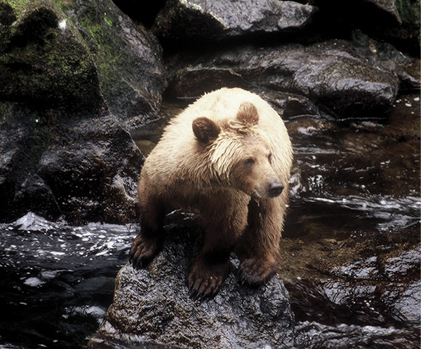
brown bear
It was time to retreat. I hadn’t come to Pack Creek for—as in the Monty Python skit—abuse and an argument. We slept fitfully that night and launched at 4 AM, hoping to avoid the rangers and start the new day with a different perspective. As we passed by Pack Creek’s broad alluvial fan, a mama grizzly with two curious cubs came out to dig for grubs and clams. One cub stood up to get a better view of us. We snapped photographs. It was going to be a great day.
Pack Creek: Pack Creek (mile 349/1,117) enters Seymour Canal at the north end of Windfall Harbor. Windfall Island, the ranger station and campsite location, is less than 0.5 mile offshore, fronting the harbor and creek delta. Do not land anywhere near Pack Creek. There are two designated free campsites, one on the southern tip in the forest and one on the east shore near the north end. There is room for more than one party. The ranger station is in a small bight directly opposite the Pack Creek delta.
The observation tower is about 1 mile up the creek along a well-developed trail accessed from the south end of the alluvial fan. Pack Creek bears are people accustomed and not hunted, so dangerous confrontations are rare. Stay on the trail, follow all the regulations, and bring no food. Most visitors arrive by air charter and are escorted. The observatory is open from 9 AM to 9 PM. Between June 1 and September 10, a fee and permit are required. Bear activity climaxes during July and August. Permits may be obtained from the Forest Service Information Center at Centennial Hall, 101 Egan Drive, Juneau, AK 99801, and the Admiralty Monument office in Juneau. Apply in person, by mail, or by phone at 907-588-8790. Permits are available March 1 each year, and they are good for up to three days. Make reservations well in advance. Pack Creek is extremely popular and the rangers are unlikely to make exceptions.
Absent a valid permit, there are other likely bear-viewing opportunities inside Windfall Harbor or, farther up Seymour Canal, in Swan Cove. The Seymour Canal Eagle Management area centers primarily on Swan and Tiedeman islands, so enjoy the unrestricted viewing opportunities.
From Pack Creek, head up the channel between Swan Island and the bulk of Admiralty Island toward Swan Cove, where there is a better than even chance of spotting a bear. Hang a sharp right and then a left around King Salmon Bay’s southern peninsula. A series of reefs, small islands, and peninsulas obstruct entry into Fool Inlet, Seymour Canal’s head of navigation. Entry is best during favorable tides.

oliver inlet tramway
The head of Fool Inlet (mile 364/1,132) dries foul, though a deeper channel leads most of the way in. Frantic paddling, lining, or knuckling upstream are viable options during low tides. Alaska State Parks maintains a visitor cabin, nestled against the hill on the east side of the low-lying area, that sleeps six and has both an oil and wood stove. A fee of $25 and reservation are required. Very limited camping is adjacent.
A narrow sliver of land, barely a mile wide, and bracketed by Seymour Canal on the south and Oliver Inlet to the north, attaches the Glass Peninsula to the rest of Admiralty Island. The isthmus is slightly humped with a long, gradual slope on the Seymour Canal side and a short, steep incline descending into Oliver Inlet from its high point. Away from the water, the shoreline vegetation gives way to taiga interspersed with open muskeg. It is a portage route long in use prior to contact. The state has built a roller-coaster tramway to facilitate and modernize the portage. If in working condition, it’s a hoot to use.
The southern terminus of the tramway is just north of the cabin. If the tram cart is absent, you’ll have to walk to the Oliver Inlet side to retrieve it. The cart easily carries two kayaks and two people’s gear. A towline may or may not be attached. Verify that the brakes work well. Maintain complete control even on the mildest of descents. Just prior to the steep Oliver Inlet descent, the rails have been disconnected to prevent accidents. At this point (mile 365/1,133), you must unload the tram cart and complete the portage by hand, on foot. A wooden platform with an Alaska State Parks skiff provides a novel campsite on the muskeg. There is no adequate flat ground at the Oliver Inlet end of the tramway for camping.
Oliver Inlet is narrow and 3 miles long. Time stands still here, and the merest sound seemingly reverberates for minutes. Moss-covered trees and the complete absence of wind and chop add to the spooky quality. Rapids separate the inlet from northern Stephens Passage. Best to exit near high-water slack (not at low-water slack) or during ebb. The rapids are at their worst during spring tidal exchanges. Neap tides, on the other hand, render mild riffles.
Oliver Inlet debauches into northern Stephens Passage, where tidal currents vary from 0.5 to 2 knots. Work your way eastward along the northern shore of the Glass Peninsula to an advantageous position for the 3-mile crossing to Douglas Island’s Tantallon Point. About a third of the way across, you will enter the jurisdiction of the City and Borough of Juneau. What the hell is a borough?
Borough: Traditionally, a borough was the smallest English and Scottish political entity. The concept survived a move to New York City, where it serves the same purpose, but hardly anywhere else. Delegates to Alaska’s constitutional convention were painfully aware of the territory’s scant population and its eccentric distribution: maybe two cities, a handful of towns, a brace of villages, and vast empty areas devoid of conventional rural inhabitants, often owned by the federal government. At best, growth would be fitful. So they designed a simple, flexible system of local government that allowed a maximum of local self-government with a minimum number of local government units to prevent duplication of tax-levying jurisdictions.
Instead of being subdivided into counties (or parishes, like Louisiana) like other states, Alaska was divided into a new entity: boroughs. Boroughs are ruled by mayors and councils if “organized” or directly by the state if “unorganized.” Ideally, there is no municipal government level below the borough. If the major feature of a borough is a city, then the borough is called “city and borough,” and the entire borough is run by the “city.”
Alternate Route #3: Cape Fanshaw (mile 286/1,054) to Gastineau Channel (mile 394/1,162) via the mainland coast
Although following the mainland coast precludes a Stephens Passage crossing, it is not without some risk, in particular the crossing of Holkam Bay, tidal mouth for both Tracy and Endicott Arms, both of which are spectacular side trips.
From Cape Fanshaw (mile 286/1,054), head deeper into Fanshaw Bay toward the abandoned settlement of Cape Fanshaw (291/1,059), where there’s an old abandoned fox farm. There, and about 1 mile prior, are a couple of campsites. Turn up Cleveland Passage. Currents never exceed 2 knots. Whitney Island hosts a few cabins and a nice campsite about halfway up Cleveland Passage.
Past McNairy point a delightfully indented coast dotted with sandy coves and little islands leads into Port Houghton. The mainland end of the incipient tombolo connecting the north side of Steamboat Bay with Foot Island (mile 295/1,063) is a great campsite. Farther along, both Crow Island (297/1,065) and its smaller sister to the west have campsites on their eastern points.
Cross Port Houghton near Walter Island and coast up to Point Hobart (315/1,083), where there’s a campsite just before, near the “Hob” designation on the 1:250,000 map. Hobart Bay, in spite of hosting quite a logging operation, remains a picturesque and serene spot. The state of Alaska maintains a floating dock inside Entrance Island’s protected harbor. The pier and buildings are private, though Denis Dwyer reports a small marina there.
North of Hobart Bay, just across from the twins where the 1:250,000 map says “foul” (320/1,088), the scalloped shore yields a sandy camp and is home to a large group of otters. Continuing north to Windham Bay (330/1,098), there are many places to camp along the entire coast opposite Sunset Island. Windham Bay itself is steep—and gloomy the farther in you go—but the islets at its mouth are campable.
Coursing north, the coast between Windham Bay and Dry Bay is steep, with only two small coves (at miles 337/1,105 and 338/1,106) yielding camps just before Dry Bay. Dry Bay (mile 339/1,107) itself has a sandy camp about halfway in, but it’s a bit gloomy and falling water levels must be negotiated (though there is a channel) during low tides.
Paddle up to Point Astley, south entrance to Holkam Bay and gateway to Endicott and Tracy Arms, low-budget versions of Glacier Bay.
Holkam Bay: Holkam Bay is the ungated lock into Endicott and Tracy Arms, long fjords that penetrate deeply—both vertically and laterally—into the Coast Range’s ice fields. As such, dangerously fast currents, along with giant icebergs, surge in and out during tide changes. Tidal currents regularly reach 4 knots, forming swirls, eddies, and reverse flows in the mouths of the main channels. Additionally, more and more cruise ships are touring up Tracy Arm. Proper timing of the crossing at slack is mandatory. Possible—though not confirmed—campsites might be found along Wood Spit at the south entrance and on Harbor Island near the cabin site, or along Harbor’s northeast shore. Denis Dwyer reports a “wilderness ranger station on a small island at 57°45.495N × 133°36.700W.”
A side trip up Endicott Arm to Ford’s Terror and the Dawes Glacier yields spectacular high granite mountains with hanging glaciers, vertical cliffs, waterfalls, and rapids at the mouth of Ford’s Terror. Entry into Ford’s Terror at high water slack is not difficult, but at other times currents can run 15 knots. There are few landing spots.
Tracy Arm, a beautiful fjord with impressive vertical granite walls, extends north and east for 22 miles. At times, South Sawyer Glacier, at Tracy’s head, is very active, calving huge blocks of ice into very deep water. There are few campsites. Most popular are valley mouths, one on each side of Tracy Arm, about 17 miles from Harbor Island. According to Jim Howard in Guide to Sea Kayaking in Southeast Alaska, it is “also possible to camp farther on at the mouth of the valley on the south side of Tracy Arm between South Sawyer Glacier and the inlet into Sawyer Glacier.”
Now for the crossing of Holkam Bay. Part 1, Endicott Arm: The narrowest point of constriction, and therefore where the strongest, squirmiest currents are found, is between the end of the string of islets tailing Wood Spit and the tidal flats just south of Sand Spit, and between Harbor Island and Sand Spit. Avoid these areas except at dead slack. At low tide slack, Sand Spit is surrounded by tidal sand flats. Better to cross the 1 mile from the end of Wood Spit to Round Islet at dead slack; or cross the 3 miles from Point Astley to Harbor Island around slack time. The second option, though longer, is more forgiving, as the current is slower. Since the channel quickly opens up to about three times wider than its narrowest point, currents spread and relax.
Part 2, Tracy Arm: Crossing Tracy Arm’s mouth is more critical. Tracy Arm’s narrowest point of constriction is between the end of Sand Spit and the shoal island off the southeast corner of the Snettisham Peninsula. Farther out, between Harbor Island and Snettisham’s south coast, the width of the channel only doubles from its narrowest point and remains uniform for some distance until out into Stephens Passage. Conditions here, for a kayak, are grim while the tides run. Time the crossing right at slack.
Don’t make the mistake of attempting to gauge the speed of the current by monitoring the movement of the bergs and bergy bits from the beach on Harbor Island like we did. Big mistake! Such a low-profile perspective throws reality out of whack. The exact location of the inlet mouth’s occlusion is distorted, berg movement is deceptive—as they often run aground erratically—and berg size and location are a guess. Additionally, without a bird’s-eye view, eddies and countercurrents are invisible.
Aim for the wonderful, sandy camp (352/1,120) in a cove on the center of the south coast of the Snettisham Peninsula, a perfect place to observe the changing tidal drama, the ebb and flow of icebergs, and the parade of boats of every size after a successful crossing.
Though steep and long, the Snettisham Peninsula’s west coast is not without haul-out spots. The two creeks bracketing Meigs Peak, opposite the Midway Islands, both have campable mouths (miles 358/1,126 and 360/1,128). Likewise, immediately north of Point Anmer (mile 367/1,135), two successive coves each have a campsite.
After Tracy and Endicott Arms, Port Snettisham, another classic long fjord with steep sides and deep water, looks like a troublesome crossing. Even the Coast Pilot reports “moderately heavy tide rips are sometimes found at the entrance.” Luckily, Port Snettisham is neither as long as Tracy and Endicott, nor does it carry as much water. We encountered no difficulties. Point Styleman (mile 370/1,138), at the north entrance to Port Snettisham, has a campsite. Inside Port Snettisham, at the head of Speel Arm, a large hydroelectric plant supplies much of Juneau’s power.
Heading north from Point Styleman, Stephens Passage noticeably narrows. One mile south of Limestone Inlet, a mile-long inlet (mile 374/1,142) parallels the coast. Inside there’s a campsite. Limestone is the site of ongoing research into the ecology of temperate coastal rain forests; it’s short but we didn’t explore it.
Taku Harbor: Three miles up the coast from Limestone, Taku Harbor (mile 378/1,146) scoops a haven out of the coastal ramparts. The well-placed and popular anchorage started life as a Hudson’s Bay trading post. At the turn of the twentieth century it became the site of a large commercial cannery with permanent residences. Though the remains of piers, boilers, bunkhouses, and electrical generators are being overtaken by dense brush, much still survives and one bunkhouse is still in use. Bear continue to fish for salmon in the two streams at the head of the harbor and will occasionally amble dockside.
Taku is a quiet, picturesque refuge popular with every passing boat. The large T-shaped public float by the old caretaker’s cabin along the middle of the east shore had to be supplemented by another public float, unattached to shore, just inside Stockade Point. The USFS keeps a public recreation rental cabin a short walk south of the big float. Trails connect the float, ruins, and rental cabin.
Where to pitch a tent is a bit of a concern. There’s a flat spot at the south end of the trail, but it floods during spring tides. The best spot is in front of the rental cabin’s picnic table. If there’s a lodger, ask permission.
Kelp
Any landing in Taku Harbor (other than at the dock) requires stepping on and walking over the snap, crackle, and pop of what looks like chopped salad greens. By now you’ve seen plenty of it, both floating free and anchored to the intertidal shore. This rock weed is a species of kelp known as bubble kelp (Fucus sp.) for the mitt-shaped globules—source of the Rice Krispies sound—that complement the leaves.
Kelp is a marine plant elegantly adapted to the aquatic environment. It has no roots; instead, a holdfast attaches it to the sea floor and the entire surface of the plant—holdfast, leaves or blades, floats, bubbles or pneumatocyst, and stem or stipe—absorbs the ocean’s nutrients. The floats hold the leaves close to the surface to maximize photosynthesis. According to Jennifer Hahn in Spirited Waters, “. . . seaweed is so renowned for its ability to siphon trace minerals from the ocean that some dietitians attribute the low incidence of premenstrual syndrome among Japanese women to a diet high in sea vegetables.”

kelp
There are three different sorts of kelp commonly found along the Inside Passage: bubble kelp, bull kelp, and wing kelp. Most are edible. Bubble kelp is restricted to the upper reaches of the Panhandle by temperature sensitivity. Though a plant, it acts more like an animal when reproducing. The tiny, motile male sperms outnumber the large, immobile female eggs. The race goes to a single winner. Bubble kelp starts life attached to the intertidal seabed but later on breaks away and floats freely. Sun dried or oven baked with suitable spicing, the floats turn into a crunchy snack.
Bull kelp (Nereocystis luetkeana), with its hollow holdfast topped by a tennis ball–size pneumatocyst, can grow up to 100 feet in length with leaves measuring up to 30 feet. The holdfast grips so tightly that not even the fiercest storms can uproot it, as no doubt you found out if you grabbed it to make upstream progress in Griffin Passage. Amazingly, bull kelp only has a one-year life cycle with extraordinary daily growth during warm months. Vast numbers die during winter and float away or accumulate on beaches, decomposing and adding stench and nutrients wherever they end up. It is by far the most abundant and widely distributed kelp along the Inside Passage.
Ribbon or wing kelp (Alaria crispa) is shaped like a feather with a yellow midrib running up the leaf’s center. It has no float and a life cycle the complete reverse of bull kelp. In winter, wing kelp grows prolifically—up to 1 inch a day—reaching lengths of 40 feet, but loses its grip in the spring, when storm waves easily dislodge it. Jennifer Hahn calls it the “asparagus of the sea” because it cooks up tender like asparagus in soups. It’s found along the Alaska Panhandle and as far south as the Queen Charlotte Islands.
North of Taku Harbor the shore remains steep and high. Butler Peak, a distinctive conical mountain, soon comes into view. Suicide Cove (mile 382/1,150), at its base, has a campsite inside while Slocum Inlet, on Butler’s north side, is filled with foul sand flats. However, kayaker Susan Conrad reports “a small pebble crescent beach nestled into a slim indentation just north of Slocum Inlet.”
Head up the coast into Taku Inlet’s mouth to where the Port Snettisham-Juneau power line descends to cross the inlet via an underwater cable (mile 386/1,154). The site is graced by a waterfall and yields a campsite, a nice spot to wait for good conditions for the crossing of Taku Inlet.
While winter sea states at the mouth of Taku Inlet are some of the worst encountered along the entire Inside Passage, a summer crossing is usually no big deal. The inlet is short, shallow at its head, and not constricted at its mouth, so run-of-the-mill tidal currents don’t warrant special consideration. Ebb currents are stronger than floods, reaching a maximum of 3 to 4 knots during spring tides. Head for Bishop Point.
About halfway between Bishop and Sansbury Points at mile 390/1,158 is the last camp spot before Juneau, a flat white sandy beach with a beautifully carved stone memorial leaning against a low cliff. Four miles on, this alternate route rejoins the main route.
Main Route: continued . . .
Gastineau Channel: Gastineau Channel separates Douglas Island from the mainland and extends about 16 miles, connecting upper Stephens Passage with Saginaw Channel. Juneau, Alaska’s capital, lies about halfway up the channel. Tantallon Point marks the west side of its south entry. The east side of the channel is defined by the mainland’s Point Salisbury where, just a couple of miles to the east at Grindstone Creek, the Taku Tlingit had a village. When Vancouver entered Gastineau Channel in August 1794, it was so choked with ice from the Taku and Mendenhall Glaciers that he was unable to complete his investigations. Currents in the lower portion are of no particular concern until the vicinity of Juneau where, near the Douglas-Juneau Bridge (including the Harris and Aurora Harbors), they can become quite strong. Gastineau Channel is narrow and carries a great deal of traffic and shipping, particularly huge cruise ships.
Immediately beyond Point Tantallon, Juneau exurbs are evident and increase in density as you progress north. Look for frantic salmon runs along the mainland-side watersheds and beware of traffic.
Juneau: The Juneau metropolitan area is large, with a population exceeding 30,000 and more choices than I could reasonably outline here. Where to head for? Seven miles up Gastineau Channel, on the left, is Douglas. Another 2 miles up, the Douglas-Juneau Bridge connects the two. Farther on, immediately past the bridge in Juneau proper, is the Harris Boat Harbor, the only other launch ramp (at its northern end) near downtown Juneau. The harbormaster’s office for both Harris and Aurora Harbors is located at the south end of Aurora. Just across Egan Drive and slightly kitty-corner from the harbor is the Breakwater Inn, with reasonably priced and accessible lodging catering to seafaring folk from the Aurora and Harris marinas. It includes a decent restaurant.
Juneau Harbor is very busy, and made more so because, for all intents and purposes, Gastineau Channel dead-ends at Juneau, and shipping must U-turn to exit. As if multiple cruise ships of all sizes, commercial shipping, and private boats were not enough of an obstacle, the Seadrome Dock is also downtown and, during passable weather, the source and destination of interminable seaplane traffic. The prudent will approach Juneau up the Douglas Island side of the channel and cross over under the bridge. But where is the fun in that?
Going up the Juneau side of Gastineau is much more exciting and puts the paddler in the thick of things. Stay close to shore to avoid docking, launching, and maneuvering craft of all sizes. You may have to pass up to six giant cruise ships, sometimes double-parked. Stay close but not too close; make sure they’re not about to move; and don’t go near the business end. Past the seaplane dock, traffic eases up. Still, don’t interfere with operations at the Coast Guard dock, the last of the obstacles to watch out for.

The unprepossessing, concrete-lined watercourse coming in at the top of the bay and just beyond downtown proper is historic Gold Creek, maternity ward and wet nurse for infant Juneau. Adjacent to the east bank but not visible from the water is a well-stocked grocery and liquor store.
Nearby, and visible, is the Prospector Lodge, a more-or-less handy alternative to the Breakwater Inn if the latter has no vacancies.
Although Juneau was founded and built on mining, today tourism and government are the mainstays. In seasonal respects, they’re complementary. Legislative sessions convene during the winter, when Juneau swarms with representatives and lobbyists. The much larger tourist run swarms the capital in summer. Juneau would probably be much larger were it not for its isolation. Although engineering proposals have been drawn up to extend Juneau’s roads to connect with the Al-Can Highway, residents invariably vote the initiatives down in fears that, with the influx of unsavory transients, they’ll lose their small-town atmosphere. The proposed road would traverse the pristine Taku River valley, already threatened by the reopening of the Tulsequah Chief mine.
There is much to see and do in Juneau. The city lies along a narrow strip of land between Gastineau Channel and a sharply abutting salient of the Coast Range. There are many improved day hike (or shorter) trails that depart right from downtown. One of the best starts out at the end of Sixth Street and goes up to the terminus of the Mount Roberts aerial tramway. Views of the city and surrounding area—including a true perspective of the gargantuan size of cruise ships—are incomparable. You can descend via the tramway. If nothing else, venture up for a reconnaissance of Mendenhall Bar, the northern half of Gastineau Channel and the next portion of the Inside Passage. A shorter but more popular hike is the Perseverance Trail, accessed from Basin Road at the intersection of Sixth and East Streets. It parallels the upper reaches of Gold Creek.
Juneau is a walking town. Don’t miss the old residential districts nestled up against the mountains, where much of the walking takes place along wooden boardwalks lined with historic clapboards, shanties, toeholds, and newer homesteads. Up here you can visit the tiny, octagonal St. Nicholas Russian Orthodox Church. Although built in 1894, nearly 30 years after Russia sold the Alaska colony, St. Nicholas is the oldest original Russian church in Alaska. Nearby is the Wickersham State Historic Site, home of Judge James Wickersham. Wickersham came to Alaska in 1900 and was instrumental in converting military rule to civilian government and subsequent territorial status. He became Alaska’s voteless delegate to Congress and a strong advocate of statehood, which he failed to realize, dying 20 years before the 49th state was admitted.
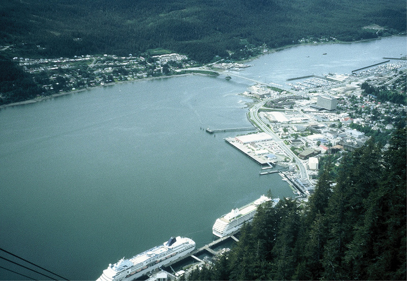
juneau and gastineau channel
Juneau’s downtown caters to the tourist trade. Among the many curio shops are some fine native art galleries and numerous eateries. Merchants Wharf, adjacent to the seaplane float, hosts The Hangar, a medium-priced restaurant overlooking the harbor with excellent food and a seemingly limitless selection of draught and bottled specialty beers. Next door is a fast-food, fish-and-chips purveyor whose halibut and salmon are second to none. The Alaska State Museum, on Whittier Street, covers all aspects of Alaskan history in a vibrant, up-to-date manner with rare and insightful Native Alaskan displays.
If you drove up to Prince Rupert to paddle this section of the Inside Passage with a hard-shelled boat, you must now catch the Alaska ferry back to Prince Rupert. Unfortunately, the ferry terminal is 14 miles away in Auke Bay, and conventional taxis are ill equipped for the task. Contact either Alaska Boat & Kayak at the Auke Bay Marina (907-789-6886) or Auke Bay Landing Craft, also in Auke Bay (907-790-4591) for kayak transport or storage. We took a more entrepreneurial approach, keeping a sharp eye out for vehicles with kayak racks. (There are many.) We focused on rattletraps, or at least vehicles that indicated their drivers would welcome a modest supplementary honorarium, and approached the mark with a generous offer. Our very first target accepted.

st. nicholas russian orthodox church
Alternatively, you could paddle the 14 miles to Auke Bay, either after a visit to Juneau or as the destination point for this portion of the Inside Passage. Take out at the Auke Bay Marina about 2 miles east of the ferry terminal at the head of Auke Bay. Paddling upper Gastineau Channel, called Mendenhall Bar, requires some preparation. See the next chapter for details.
Another approach is to store the kayaks in Juneau until the next leg of the Inside Passage. Use the same strategy as above, but focus on storage instead of transport. Ferry or fly back to Prince Rupert. Juneau’s airport is 9 miles west of downtown. If you arrived in Juneau via folding kayak, logistics are much simpler.