With the civil engineer, more properly so called (if anything can be proper with this awkward coinage), the obligation starts with the beginning. He is always the practical man. The rains, the winds and the waves, the complexity and the fitfulness of nature, are always before him. He has to deal with the unpredictable, with those forces (in Smeaton’s phrase) that ‘are subject to no calculation’; and still he must predict, still calculate them, at his peril. His work is not yet in being, and he must foresee its influence: how it shall deflect the tide, exaggerate the waves, dam back the rain water, or attract the thunderbolt.
Robert Louis Stevenson often accompanied his grandfather on site visits and appreciated his skills. The Charter of the Institution of Civil Engineers speaks of ‘directing the great sources of power in nature’. In late 2010 and 2011 (to take a short sampling period) there were earthquakes in New Zealand and Japan; the Japanese earthquake was followed by a devastating tsunami (tidal wave); there was major flooding in Queensland, Australia, and also in Thailand. Society expects that structures will survive and that the infrastructure will be protected, but can we really ‘direct the great sources of power in nature’?
Cnut the Great (king of England AD 1016–1035 and also eventually king of Denmark and Norway) famously (though probably apocryphally) allowed himself to be placed in his throne on the beach of the English Channel near Portsmouth at low tide in order to indicate to his dismayed followers that he – although a king – was unable to prevent the continued advance of the tide. Conditions on that day were probably reasonably calm. It is unlikely that Cnut, realistic about the inexorable nature of the tides, would have expected to be able to exert any control over the weather, but anyone living near the coast is very aware of the awful character of the sea when the tide is high and a storm is brewing. The attempts of man, whether a king or not, to demonstrate some dominance over nature can then seem particularly puny.
There are regularly more or less serious floods in different parts of the world. Some of these are simply the result of unusually high quantities of rainfall which overload the natural river channels, often exacerbated by changes in land use (such as the felling of areas of forest) which encourage more rapid runoff or impose a man-made canalization of the river (by building on flood plains into which the rising river would previously have been able to spill) (Figure 19). Some of the incidents are the result of unusual encroachments by the sea, a consequence of a combination of high tide and adverse wind and weather conditions. The potential for disastrous consequences is of course enhanced when both on-shore and off-shore circumstances combine.
In May 2011, the US Army Corps of Engineers opened sluices or breached levees on the Mississippi in order to reduce flood levels in the river and allow the water to flow into the adjoining floodplains (inundating farm land and small settlements) rather than flooding cities downstream: not an easy decision to make, balancing costs and benefits. Folk memory for natural disasters tends to be quite short. If the interval between events is typically greater than, say, 5–10 years people may assume that such events are extraordinary and rare. They may suppose that building on the recently flooded plains will be safe for the foreseeable future.
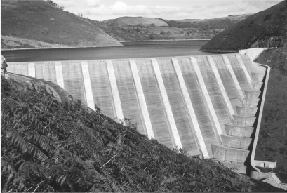
19. The 72 m high Clywedog Dam in mid-Wales is formed from a row of 11 concrete buttresses. The level of the reservoir is controlled to smooth the peaks and troughs of flow in the upper River Severn (of which the Afon Clywedog is a major tributary) and reduce the likelihood of flooding
‘Once did she hold the gorgeous East in fee; … Men are we, and must grieve when even the Shade of that which once was great is pass’d away.’ Wordsworth regretted the subjugation of the Venetian republic following the depredations of Napoleon and his armies, but he might have had a similar reaction today if he had been there during one of the periods of high water (acqua alta) which submerge extensive regions of the city with some regularity. Construction of a protective barrier to keep high water in the Adriatic from the Venice Lagoon is in progress, but the city will continue its steady stately settlement partly exacerbated by earlier pumping of water from a deep aquifer in order to supply the adjacent industrial area of Marghera, and partly the result of continued geological movements and sea level rise associated with climate change. Acque alte have become a fact of life in Venice: tides which reach 1.3 m and cover 40–50 per cent of the area of Venice occur roughly once a year. But much higher tides also occur less frequently. The rarer events, like the floods in the North Sea in 1953 and in New Orleans in 2005, can produce much more damage.
On the night of 31 January 1953 a combination of high spring tide and a severe depression produced a tidal surge in the southern parts of the North Sea, along the coastlines of south-east England and the Netherlands, which was locally more than 3 m above mean sea level, with waves up to 6 m high. Around 1600 km of flood protection dykes were overwhelmed in England and some 1000 square kilometres of land beyond inundated; 307 people lost their lives. In the Netherlands 1835 people lost their lives and 1365 square kilometres were flooded including about 9 per cent of Dutch farmland.
In the Netherlands, an ambitious flood defence system – Deltawerken (Delta Works) – was designed to protect the estuaries of the rivers Rhine, Meuse, and Scheldt against flood events with an annual probability of occurrence of 0.01–0.025 per cent. The last element of this Delta project to be completed was the storm surge barrier Maeslantkering, in the Nieuwe Waterweg, near Rotterdam in 1998. However, the closure of the east branch of the Scheldt in the 1970s and 1980s caused much more concern and international interest. By this time environmental groups were becoming more vociferous and objected to the permanent closure of the river with the changes to the natural habitat that would be caused in the no longer tidal areas. Which takes priority? Birds and flowers – or people and property? It is not possible to produce a precise balance sheet of costs and benefits: what is the value of a stretch of tidal mudflat? We can probably put a fairly accurate value on the property and agricultural land that might be damaged by flooding – but putting a precise figure on the loss of human life? These become political issues which form elements of environmental impact assessment for engineering projects.
So far as the Oosterschelde (eastern Schelde) was concerned, the most popular environmental choice was to provide a structure with a series of 62 sluice gates each 42 m wide, closed only when adverse weather was expected, spanning between concrete pillars, each placed on specially prepared fabric mattresses filled with sand and gravel on the seabed. The foundations have to be designed to withstand the substantial out-of-balance water pressure when a tidal surge is being resisted, together with repeated wave loading with a frequency of the order of 1 Hz which could liquefy the sand. Think back to your experiences on the seashore and the way in which saturated sand, shaken by your foot, rapidly loses its strength and seems to become a liquid: this is another potentially damaging phenomenon which has its origin in the particulate nature of soils.
The tidal habitat has been preserved, but the blockage of even part of the section of the river channel by the piers of the barrier has changed the flow regime to such an extent that movements of sand and shingle by the sea along the coast of the Netherlands have been affected. The movement – and deposition – of offshore sediments is very sensitive to details of the shape and form of the coastline.
In the UK, after the 1953 flooding, protection against recurrence was provided through major investments in raised coastal embankments and through the construction of the Thames Barrier – a miniature version of the Oosterschelde structure – with four 60 m and two 30 m navigable openings which can be closed by rotating, using buoyancy, segmental steel gates which normally sit on the bottom of the river, full of water. The detailed planning of this barrier was delayed because of the need to maintain free access for substantial cargo ships to the main docks of the Port of London. With the expansion in the 1960s of Tilbury Docks downstream of the chosen barrier site, the requirements for the provision of navigable channels were reduced. These investments are intended to protect against tidal surge events with a return period of 1000 years – an annual probability of 0.1 per cent.
Most of the land in the coastal areas of the south-east of the UK is above sea level. These are areas of comparatively recent geological age consisting of deposits of stiff clay (which has been densified by the weight of overlying glaciers and rocks which have now been eroded away), and weak rocks; the chalk which forms the white cliffs of Dover and other landmarks is typical. Erosion of the coastline through the constant battering of the sea and its waves continues. The sea is not easily subdued. The interaction of sea and shore would naturally lead to a coastline quite different from that with which we are presently familiar. A confident civil engineer might attempt to hold the sea back using hard structures, shaped to throw the energy of the water back offshore. Such structures are costly and require regular maintenance in response to the ravages of the sea.
Structures projecting out to sea from the coastline, such as groynes or breakwaters, may be completely impermeable to the passage of water and may provide protection to a harbour from the prevailing currents. Alternatively, they may be deliberately porous: piles of rock or cast concrete units, or even open timber structures. Breakwaters are intended to reduce the energy of the sea and so deposit sediment (sand and shingle). Attempting to tamper with nature by encouraging deposition at one location is to prevent deposition (encourage erosion) somewhere else. The offshore environment is very dynamic and interactive.
Where the density of coastal population is relatively low, ‘managed retreat’ may provide a more economic (and fatalistic) response to the unequal battle between sea and shore. Isostatic uplift – the natural rebound of the earth’s surface as overlying ice melts and/or rock erodes – together with increases in sea level resulting from anthropogenic or naturally occurring changes in global climate – expose to the sea soils and rocks which would naturally be continually removed. Why resist? Salt marshes, flooding land previously reclaimed from the sea, provide rich habitats for wildlife, a luxury of the developed western world. The loss of a few coastal settlements is hardly a new phenomenon. Unnatural man-made hard coastal defences are replaced with soft natural means of absorption of wave energy to improve protection of areas further inland. The coastal sea regains its natural mechanisms of sediment transport and transfer. Evidently, the deliberate sacrifice of coastal property in the interests of long-term economy is socially controversial. In regions of the world – such as Bangladesh – with extremely high densities of population in vulnerable low lying coastal areas the possibilities of preserving existing settlements as sea levels inexorably rise seem bleak.
It wasn’t the miles of buildings stripped of their shingles and their windows caved in or the streets awash with floating trash or the live oaks that had been punched through people’s roofs. It was the literal powerlessness of the city that was overwhelming. The electric grid had been destroyed and the water pressure had died in every faucet in St Bernard and Orleans parishes. The pumps that should have forced water out of the storm sewers were flooded themselves and totally useless. Gas mains burned under water or sometimes burst flaming from the earth, filling the sky in seconds with hundreds of leaves singed off an ancient tree. The entire city, within one night, had been reduced to the technological level of the Middle Ages.
The disaster that struck New Orleans in 2005 provided the factual background for a gritty novel by James Lee Burke more extraordinary than any fictitious description.
New Orleans is located in the Mississippi River Delta on the banks of the Mississippi River and south of Lake Pontchartrain, 170 km upriver from the Gulf of Mexico. Originally located on the natural levees and high ground along the Mississippi, the city was given permission early in the 20th century to put into effect a drainage plan for the swamp surrounding the city in order to permit expansion and, it was hoped, economic growth. Pumping for drainage increases the stresses in the soil, leading to subsidence of the drained ground, as in Venice. Some parts of the city are as high as 6 m above sea level but the average elevation is about 0.5 m below sea level: some locations are as low as −3 m. Climate change produces a small annual rise in sea level, and there is continuing lowering of the level of the delta sediments as a result of both continued pumping and also the loss of organic surface materials through oxidation by exposure to the air. Ironically, before many of the protective flood control structures were constructed the Mississippi would have kept the delta topped up with new sediments to counter some of the subsidence. Such are the unintended consequences of human intervention.
New Orleans has always been vulnerable to flooding. Flooding caused by Hurricane Betsy in 1965 killed 76 people. The subsequent Flood Control Act of 1965 required the US Army Corps of Engineers to design and construct flood protection in the New Orleans metropolitan area, but in 2005 completion was forecast for 2015. Heavy rain in May 1995 revealed the inadequacy of the pumping system. Both of the elements – protection and pumping – which might have reduced the extent of flooding were in an uncertain state when Hurricane Katrina arrived on 29 August 2005, producing intense winds and a tidal surge.
The failure of most of the protective levees throughout the metropolitan area left 80 per cent of the city underwater – in places to a depth of 4.5 m. Some failed because the embedment of the walls was insufficient to withstand the very high water pressures; others were overtopped for a sufficient time to permit erosion of the banks of the levee. Around 1500 people died.
As with other natural disasters – such as earthquakes – it was not just the damage to property but also the destruction of the local infrastructure of a major city which shocked the world. Failure of power supplies and power lines halted many communications systems; most roads out of the city were damaged; local television and newspapers were disrupted; emergency services and doctors and hospitals were unable to function; police forces were unable to prevent widespread looting. Everything that we regard as part of the normal infrastructure for civilized urban existence was disrupted in a way that revealed the lack of robustness of the systems: a failure in any one location had implications that extended over a disproportionately larger area.
The assessment of the probability of occurrence of extreme events is not easy – by definition there will be few data points. Katrina was an event with a return period of 100–400 years – an annual probability of occurrence of 0.25–1 per cent. Reconstruction and improvement works since Katrina have improved the protection of New Orleans against events with a return period of roughly 100 years and will reduce the impact of rarer more serious events.
The great sources of power in nature are there and will continue to overwhelm man from time to time. We can design to resist these natural phenomena – building on the experience of past magnitudes of earthquakes, typhoons, floods – and constantly updating our statistics of occurrence to improve the accuracy of our forecasts of the likelihood that events of a particular magnitude such as intensity of earthquake, wind speed, rainfall, or flood level, might occur. But an estimate of the probability of occurrence of an event does not define the frequency with which such events will occur. A 200 year flood may occur on average once every 200 years, but the probability that it will occur in each successive year is the same – and it could indeed occur each year in succession for many years without upsetting the statistics which relate to the probability of occurrence over hundreds or thousands of years. Risks can be reduced and delayed but never eliminated. It is important that the nature of such risks should be both advertised and understood. The North Sea flooding in 1953 led to the reactive construction of flood protection systems round the coasts of the Netherlands and the south-eastern UK, but the flooding produced by Katrina in New Orleans gives an illustration of the speed with which everything that we take for granted in the infrastructure of our 21st century civilized life can be eliminated.
Major earthquakes occur every year in different parts of the world. The various continents that make up the surface of the Earth are moving slowly relative to each other. The rough boundaries between the tectonic plates try to resist this relative motion but eventually the energy stored in the interface (or geological fault) becomes too big to resist and slip occurs, releasing the energy. The energy travels as a wave through the crust of the Earth, shaking the ground as it passes. The speed at which the wave travels depends on the stiffness and density of the material through which it is passing. Topographic effects may concentrate the energy of the shaking. Mexico City sits on the bed of a former lake, surrounded by hills. Once the energy reaches this bowl-like location it becomes trapped and causes much more damage than would be experienced if the city were sitting on a flat plain without the surrounding mountains.
Designing a building to withstand earthquake shaking is possible, provided we have some idea about the nature and magnitude and geological origin of the loadings. Taiwan is a seismically active country – the magnitude 7.6 Chi-Chi earthquake of 21 September 1999 killed 200 people. The Taipei 101 building (Figure 20) in Taiwan was, for six years from 2004, the tallest building in the world. One way to counter the oscillation of a somewhat flexible building induced by ground movement in an earthquake is to include a tuned mass damper as a passive means of extracting energy from the movement of the building. The tuned mass damper is a heavy pendulum at the top of the building which is tuned to a frequency close to that of the building and is connected through dampers (shock absorbers). The Taipei 101 damper takes the form of a golden sphere of mass 730 tonnes, built up from steel plates, suspended from eight steel cables, and connected through eight dampers. It is very much on display to visitors who come to the viewing galleries around the 90th storey and who are encouraged to look inwards as well as outwards. It provides an opportunistic but low key example of the importance (and beauty) of civil engineering and the contribution that it makes to the safety of the built infrastructure.
20. The skyscraper known as Taipei 101 contains a tuned mass damper in the form of a gold-painted sphere of steel plates hung from steel cables and connected to the building through shock absorbers. Its natural frequency matches that of the building itself and helps to improve structural response under wind or earthquake loading
Earthquakes in developing countries tend to attract particular coverage. The extent of the damage caused is high because the enforcement of design codes (if they exist) is poor. The earthquake in Haiti in January 2010 was a magnitude 7 quake with horizontal ground accelerations up to about 45 per cent of earth’s gravity. It demolished schools, houses, offices, hospitals, government buildings, parliament, bridges, power stations, and water supply structures. It inevitably had a devastating effect on the life of all people in the country. Estimates of the death toll vary hugely – the number killed was probably between 50,000 and 100,000. The Loma Prieta earthquake in San Francisco in October 1989 was of slightly higher magnitude 7.1; 37 people were killed and there was damage to buildings and infrastructure but at a greatly reduced scale by comparison with Haiti. The geological fault ruptures for the two quakes were broadly similar but there were strongly contrasting effects. California has long had very detailed requirements for the design of all sorts of structures to survive earthquake loading, which are regularly updated after every earthquake occurrence, and these requirements are strictly enforced. The majority of the damage in Haiti was the result of poor construction and the total lack of any building code requirements.
Almost every major earthquake in any part of the world produces some effects that had not been directly anticipated in the development of the building codes for that or other areas. For example, the magnitude 6.8 Kobe earthquake of January 1995 combined the usual horizontal shaking (peak ground accelerations as high as about 90 per cent of earth’s gravity) with unusually high levels of vertical shaking (peak vertical accelerations up to about 46 per cent of earth’s gravity). The peaks of horizontal and vertical acceleration do not necessarily coincide. But if they do, a bridge which feels only about half its usual weight (because the ground is dropping away) is given a sideways kick. The most striking image from the Kobe earthquake is of the elevated Hanshin highway on its elegant piers which had all toppled sideways. This led to changes in the design codes in Japan and elsewhere to require allowance for such devastating combinations of ground motion.
The earthquake in Haiti is just one of many earthquakes in developing countries where the enforcement of codes is not considered important and the exigencies of daily life are challenge enough without having to worry about building to resist more or less infrequent earthquakes. There is a challenge to developed countries to design building styles which, while only subtly different from traditional styles, nevertheless improve the chances of earthquake survival. Heavy mud or tile roofs on flimsy timber walls are a disaster – the mass of the roof sways from side to side as it picks up energy from the shaking ground and, in collapsing, flattens the occupants. Provision of some diagonal bracing to prevent the structure from deforming when it is shaken can be straightforward. Shops like to have open spaces for ground floor display areas. There are often post-earthquake pictures of buildings which have lost a storey as this unbraced ground floor structure collapsed.
The energy in the shaking ground is large, and the movements and location of earthquakes unpredictable. The very least we can do is to study local geology to spot geological faults which look as though they are storing up energy to be released in a future slip. We can also learn from past events and apply the knowledge gained to the improvement and enforcement of appropriate standards of construction.
The deck of a suspension bridge has simply to span between the hangers that link it to the suspension cables. However, while the weight of the deck and the traffic that it carries may be the dominant load on the bridge, there may well also be significant horizontal wind loading transverse to the line of the bridge.
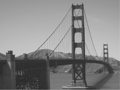
The Brooklyn Bridge in New York and the Golden Gate in San Francisco (Figure 21) have decks (and towers) which are formed of steel lattices. The Tacoma Narrows bridge famously demonstrated the potential for interaction of wind with an intervening bluff body – one that makes no attempt to encourage the smooth flow of the air. Opened in 1940, and known as ‘Galloping Gertie’, it lasted just four months before it twisted itself to destruction as a result of resonant torsional oscillations generated by wind-induced vortices.
21. The Golden Gate Bridge in San Francisco has steel towers and truss deck which have to resist the lateral buffeting resulting from wind loading
The rules of structural mechanics that govern the design of aircraft structures are no different from those that govern the design of structures that are intended to remain on the ground. In the mid 20th century many aircraft and civil structural engineers would not have recognized any serious intellectual boundary between their activities. The aerodynamic design of an aircraft ensures smooth flow of air over the structure to reduce resistance and provide lift. Bridges in exposed places are not in need of lift but can benefit from reduced resistance to air flow resulting from the use of continuous hollow sections (box girders) rather than trusses to form the deck. The stresses can also flow more smoothly within the box, and the steel be used more efficiently. Testing of potential box girder shapes in wind tunnels helps to check the influence of the presence of the ground or water not far below the deck on the character of the wind flow.
Built within a very few years of each other, the suspension bridges across the Forth (near Edinburgh, 1006 m span, completed in 1964) and the Severn (near Bristol, 990 m span, completed in 1966) adopted the contrasting deck forms of truss (Forth) and aerodynamically shaped box (Severn). The rapid adoption of box girders turned out to be a jump in technology which in fact required extensive further development. Collapses of box girder bridges in Wales and Australia while they were being constructed in the early 1970s indicated a need to understand more carefully how the stresses would flow round the irregular cross-section of the box. Hollow sections (even aircraft fuselages) require some internal stiffening (shear stiffening) to discourage them from changing in shape under load (just as the storeys of a building require shear stiffening to prevent them collapsing – changing shape – in an earthquake). A truss gives a clear picture about the route that the internal forces must take. Box girder bridges are under particular risk during construction. The failures that occurred prompted rapid research and introduction of design guidance. This then led to a major programme of strengthening (increasing the weight) of most of the bridges of this type that had been built in the UK in order that they could be deemed safe under the most critical (and increasing) traffic and environmental loads.
The damage that can be inflicted by natural movements of wind, water, and earth is enormous. We can design structures to resist or survive these movements, but do we choose to make the structure heavy and stiff so that it cannot move, but generates high internal stresses, or rather to make the structure flexible so that it goes with the flow, generating rather low internal stresses but experiencing larger movements which may be unpopular with the users of the structure?
We can also attempt to exploit these natural sources of power to contribute towards the ever increasing demands of society for energy. Almost every method of energy generation has its disadvantages. Coal is seen as a dirty fuel contributing to the build-up of carbon dioxide in the atmosphere with attendant effects on climate change. There are ways of reducing the output of carbon dioxide at the power station but these obviously put up the cost. Oil and gas are seen as cleaner fuels but their scarcity and location often in areas of the world which are not noted for their political stability suggest that long-term reliance on them as fuels is risky. Nuclear power was hailed after the Second World War as the answer to the demands for cheap energy, but the politics of disposal of spent nuclear fuel have not been resolved. Even if engineering solutions can be found, the public remains sceptical.
Hydroelectric power is a clean way of generating electricity from the reliable combination of rainfall and gravity. But today there is great concern to prevent the damage to the environment that is caused by the combination of flooded valley and controlled, possibly reduced, river flow downstream of the power station and the removal of a sometime waterfall into pipework and turbines.
Wind has for many centuries been seen as a desirable natural source of power to be tamed for the use of mankind. There has recently been a massive development of onshore and offshore wind farms in many parts of the world – groups of tens or hundreds of wind turbines generating considerable quantities of power (when the wind blows). Opinions differ as to their aesthetic contribution: the windmills (or more often wind pumps) built in northern Europe in the 17th and 18th centuries that are now seen as rather romantic relics in a rural landscape may then have been regarded as visual intrusions, notwithstanding their contribution to pumping of water, drainage of land, grinding of corn. There is a certain elegance in a group of slender modern wind turbines rotating gently – but perhaps as a distant view and not on one’s doorstep. Offshore locations may be seen as further from anyone’s backyard: the wind is stronger but there are other environmental loadings from the surrounding sea as well.
Light shining on photovoltaic cells generates electricity from silicon semiconductors – there are solar photovoltaic installations at all scales from providing illumination for individual traffic signs to powering remote lighthouses, domestic supplies and office buildings. The wind may or may not blow and the sun may or may not shine but the tide will come in and out twice a day without fail. Electricity can be generated from the tide by installing a dam across an estuary and allowing the water to flow through turbines from one side to the other depending on the state of the tide. The Rance tidal power station in northern France was the world’s first, opened in 1966. The tidal range is about 8 m and the power generating capacity is 240 MW with a 700 m dam across the estuary. As with on-shore hydroelectric power schemes there are environmental concerns with loss of habitat for birds and plants in an estuary where there would have been extensive mudflats.
The sea itself has a lot of energy in addition to the effects of the tides. Tidal current devices can be completely invisible beneath the surface of the sea – the tidal currents are encouraged to flow through turbines tethered to the seabed. Wave-power has been studied for several decades; various likely candidates have emerged but the extent of actual deployment has been modest. The invention of the devices themselves is primarily a mechanical challenge. The civil engineering challenge to anchor them to the seabed is significant: the power of the sea to generate electricity is also the power that batters the coast in stormy weather and destroys puny man-made structures that are placed in its path. The anchorage has to resist the very natural power that the devices are trying to harness. The need for interdisciplinary awareness is evident.