Squamish
. . . . .
| ROUND TRIP | 19.2 km (12 miles) |
| TERRAIN | Paved roads; flat |
| TRAFFIC VOLUME | Low except around Hwy 99 |
| ALLOW | 2 to 3 hours |
| HIGHLIGHTS | Squamish Adventure Centre, Brackendale Eagles Provincial Park, Brackendale Art Gallery, West Coast Railway Heritage Park, Squamish River, mountain views |
| PICNIC SPOT | Fisherman’s Park at the end of Brennan Road at 8.8 km |
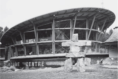
| STARTING POINT | Visitor Information Centre (Squamish Adventure Centre) on Loggers Lane |
| HOW TO GET THERE | BY CAR: From Hwy 99 North turn right (east) at the Cleveland Avenue traffic lights, then immediately left onto Loggers Lane. The visitor centre is a short distance ahead; park in the gravel parking lot opposite the centre. |
| BY TRANSIT: If you are already in Squamish, take Squamish Transit Route 1: Brackendale bus to Cleveland at Buckley and ride to the starting point. | |
| WHEN TO GO | Attend the Squamish Days Loggers Sports Festival in late July or early August or view the bald eagles in winter. |
Visitor centre, Squamish
SQUAMISH LIES at the foot of a granitic monolith, at the confluence of three major rivers and at the head of a fjord. The rugged landscape, a mecca for mountain bikers and rock climbers, might seem daunting to the cyclist looking for “easy” routes, but there are quiet, level roads through the Squamish/ Mamquam flood plain that provide peaceful riding with mountain views.
Breeze out to Brackendale, the notorious “squamish” wind at your back, pausing at Eagle Run, where from November to February each year thousands of bald eagles gather to feed on spawned-out salmon. On the dyke, a log shelter decorated by Sko-mish First Nation carvers houses interpretive panels on eagle lore.
Perhaps eight thousand years ago, the ancestors of this region’s Sko-mish people arrived at Howe Sound at the end of an unimaginable journey from Asia by way of the Bering Strait, Alaska and the northwest coast of British Columbia. Millennia later came explorers, fur traders and gold seekers and, eventually, non-Native settlers to make their home in the valley.
If you’re staying in Squamish and fancy a day out of the saddle, you could explore the network of walking trails around the estuary or visit West Coast Railway Heritage Park, now the home of B.C. Rail’s Royal Hudson steam train as well as Canada’s largest collection of rolling stock. The spectacular Squamish Adventure Centre on Loggers Lane offers a café, gift shop and theatre in addition to leaflets and maps and, of course, staff on hand to answer questions.
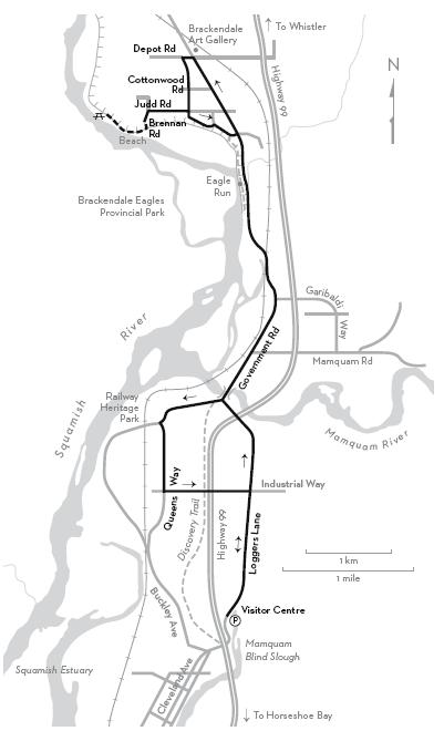
KM THE ROUTE
0.0 Squamish Adventure Centre parking area. Cycle north on Loggers Lane.
2.4 Bear left at the stop sign onto Centennial Way and continue through the Hwy 99 underpass.
3.0 Right on Government Road to cross the Mamquam River bridge.
5.6 Eagle-viewing area. The log shelter is on the dyke. Brackendale Eagles Provincial Park is opposite, across the Squamish River.
7.1 Brackendale Store and Café is on your left.
7.4 Left on Depot Road. To visit the Brackendale Art Gallery, continue a few metres farther on Government Road and look for the unicorn.
7.5 Left on Cottonwood Road.
8.1 Right on Judd Road.
8.6 Left on Brennan Road at the sign “River Access.”
8.8 Fisherman’s Park parking area. From the dyke top, a track left leads down to a sandy beach.
8.8 Backtrack on Brennan Road and turn right on Judd Road.
11.3 Right on Maple Crescent.
11.6 Right on Eagle Run Drive.
11.9 Right on Government Road.
15.2 Cross the Mamquam River bridge and go right on Government Road.
16.0 Left on Aspen Road and immediately right on Queens Way. To visit the Railway Heritage Park, continue 0.4 km farther on Government Road and turn right at the sign.
17.0 Left on Industrial Way. Cross Hwy 99.
17.9 Right on Loggers Lane.
19.2 Visitor Information Centre parking area.