Coquitlam/Port Coquitlam
. . . . .
| ROUND TRIP | 24.8 km (15 ½ miles) |
| TERRAIN | Unpaved trail and dyke and paved roads; mostly flat |
| TRAFFIC VOLUME | Low |
| ALLOW | 3 to 4 hours |
| HIGHLIGHTS | Colony Farm Regional Park, Coquitlam River, Gates and Lions Parks, urban forest, Hyde Creek Nature Reserve, De Boville Slough, Pitt River |
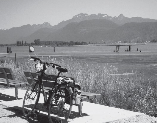
| PICNIC SPOT | There are benches along the dyke after 12.8 km |
| STARTING POINT | Shaughnessy Street parking lot |
| HOW TO GET THERE | BY CAR: From Mary Hill Bypass in Coquitlam turn south on Shaughnessy Street at the traffic lights. The parking area is just around the bend. |
| BY TRANSIT: Catch the West Coast Express to Port Coquitlam Station and ride to the starting point or take the bus to Shaughnessy at Mary Hill Bypass. | |
| WHEN TO GO | Spring or fall to see the Colony Farm lands at their best. |
| CONNECTS WITH | Coquitlam River, De Boville Slough |
Pitt River
ALTHOUGH SECTIONS of the Traboulay PoCo Trail are included in other rides (see Coquitlam River and De Boville Slough), it would be a pity not to include the entire circular route in this book.
The brainchild of Pitt River swing-bridge operator Harold Routley, the idea of a trail that would encircle the City of Port Coquitlam captured the imagination of the community. The trail was completed in 1974, its maintenance turned over to Port Coquitlam Parks and Recreation soon after. More recently, the trail was renamed in honour of the late mayor, Len Traboulay.
Improvements and changes to the trail continue to be made when necessary—at the time of writing, there is a temporary detour because of construction around the Pitt River Bridge; also, deterioration of a trail in Colony Farm lands has resulted in an agreement with the Kwikwetlem to divert the route through their reserve.
The Traboulay PoCo Trail is here to stay. Cyclists and walkers need only follow the trail signs to make a unique journey beside rivers and creeks, through urban forest and neighbourhood parks. Note that the shared trail is very popular, especially on weekends; please cycle safely and be courteous to other users.
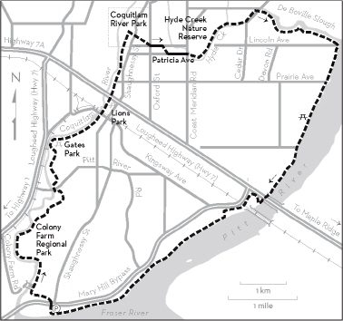
KM THE ROUTE
0.0 Shaughnessy Street parking area. Turn right from the parking lot and cross Mary Hill Bypass at the traffic lights. Look for the PoCo Trail sign on the west side of Shaughnessy Street.
1.3 Millennium Bridge, Colony Farm Regional Park. Continue on the east side of Coquitlam River.
3.1 Left through the wire gate.
4.2 Pitt River Road. There is no road crossing—follow PoCo Trail signs left and through the underpass. Continue across the Red Bridge parking lot onto the paved pathway. Follow the path around the perimeter of Gates Park.
6.5 Go through the Kingsway and the railway underpasses.
6.9 Lions Park. Picnic tables, toilets. Pass beneath Lougheed Highway.
8.3 Pass beneath the Patricia Avenue footbridge. Keep a keen eye out for PoCo Trail signs in this forested section. Watch out for other cyclists, too.
9.2 Cross Shaughnessy Street and follow PoCo Trail signs along neighbourhood trails and streets.
10.6 Cross Coast Meridian Road. Enter Hyde Creek Nature Reserve.
12.8 De Boville Slough parking area. Continue along the dyke path on the south side of the slough.
18.5 Lougheed Highway and Pitt River Bridge. Follow PoCo and other signs for bicycles through the temporary detour, until you are back on the dyke path south of the bridge.
24.8 Shaughnessy Street parking lot.