Richmond
. . . . .
| ROUND TRIP | 21.4 km (13 ½ miles) |
| TERRAIN | Paved roads, unpaved trail, gravel dyke; flat |
| TRAFFIC VOLUME | Moderate to heavy on major roads, low elsewhere |
| ALLOW | 2 to 3 hours |
| HIGHLIGHTS | Fraser River and airport activity, mountain views, Shell Road Trail, Terra Nova Waterfront Park, Terra Nova Rural Park Community Gardens, Richmond Olympic Oval |
| PICNIC SPOT | Terra Nova Waterfront Park at 14.8 km |
| STARTING POINT | Garden City Community Park or roadside parking on Granville Avenue east of the park entrance, near the tennis courts |
| HOW TO GET THERE | BY CAR: From Westminster Highway in Richmond, drive south to Granville Avenue. The community park is on Granville Avenue, just east of Garden City Road. |
| BY TRANSIT: Take the Canada Line SkyTrain to Brighouse Station and ride to the starting point. | |
| WHEN TO GO | See the community gardens at their best in July. Or go November to February to see snow geese from West Dyke Trail. |
| CONNECTS WITH | Richmond South Dyke |
ON THIS circular route you’ll sample some of Richmond’s dedicated bicycle lanes. Be prepared to cycle with traffic on these streets; although they are designated bike routes, it’s up to you to obey road signs and travel with care. By contrast, there are scenic stretches along dyke paths and on the surprisingly peaceful Shell Road Trail. From the Middle Arm Dyke Trail you can watch the constant arrivals and departures of aircraft to and from Vancouver International Airport on Sea Island and seaplane activity along the Fraser River.
The route also provides several options: Cycle the popular West Dyke Trail along the fringe of Sturgeon Bank marshes; visit a community garden where you’ll see plots of vegetables and flowers and a “waterwise” demonstration garden; take a jaunt to the Richmond Olympic Oval, built to house the speed skating events of the 2010 Olympic Winter Games and now a multi-use sports facility. The fabulous building is a model of environmental design: Rainwater from the roof is collected in the pond beneath the Water Sky Garden sculpture and used for irrigation and flushing toilets; the striking heron’s wing roof is made from wood salvaged from pine beetle–infested forests in the interior of British Columbia.
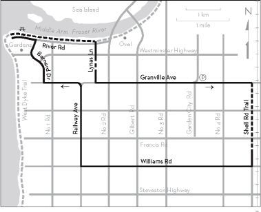
KM THE ROUTE
0.0 Garden City Community Park. Ride east on Granville Avenue.
1.5 Right on Shell Road Trail, just before the railway.
3.5 Continue on Shell Road.
4.4 Right on Williams Road.
9.2 Right on Railway Avenue.
OPTION: Continue for 1.8 km to the end of Williams Road, then go north on West Dyke Trail for 4 km to Terra Nova. To visit Terra Nova Rural Park Community Gardens, leave the dyke after about 3.5 km at Westminster Highway. The gardens are on the left.
11.6 Left on Granville Avenue at the traffic lights.
12.7 Right on Barnard Drive.
14.1 Left on River Road.
14.8 Terra Nova Waterfront Park.
Picnic tables, toilets. To continue, cycle east on Middle Arm Dyke Trail.
17.3 Descend to River Road where convenient and go right on Lynas Lane, continuing through the unpaved section.
OPTION: Stay on Middle Arm Dyke Trail for another kilometre to visit Richmond Olympic Oval. Backtrack to Lynas Lane and add 2 km to subsequent distances.
18.5 Left on Granville Avenue.
21.4 Left into Garden City Community Park (or continue to roadside parking).