Delta
. . . . .
| ROUND TRIP | 12.2 km (7 ½ miles) |
| TERRAIN | Paved roads, gravel dyke path, trail; flat |
| TRAFFIC VOLUME | Low |
| ALLOW | 1 ½ to 2 ½ hours |
| HIGHLIGHTS | Ladner Harbour Park, Captain’s Cove Marina, Deas Island Regional Park, river traffic, waterfowl, raptors |
| PICNIC SPOT | Deas Island Regional Park at 6.2 km |
| STARTING POINT | Ladner Harbour Park |
| HOW TO GET THERE | BY CAR: From Vancouver, turn off Hwy 99 at exit 29 immediately south of the Massey Tunnel. Follow River Road toward Ladner for just over 2 km and turn right on McNeeley’s Way at the sign to Ladner Harbour Park. From other directions, use Ladner Trunk Road (Hwy 10) and turn right on Elliott Street in Ladner and right on River Road. |
| BY TRANSIT: Take the bus to Central Avenue and Ladner Trunk Road or to Ladner Exchange, or catch the bike shuttle to the south end of the George Massey Tunnel and ride to the starting point. | |
| WHEN TO GO | Early spring when Deas Island eagles are rebuilding their nests and raising young. |
| CONNECTS WITH | Westham Island |
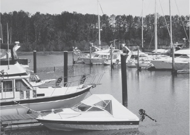
Captain’s Cove Marina
SINCE IT opened in 2003, Delta’s Millennium Trail has been popular with walkers and cyclists. With the addition of the Deas Island Link in September 2008, trail users can now continue along the dyke between Deas Slough and adjacent farmland to enjoy the riverside picnic tables, trails and heritage buildings of Deas Island Regional Park.
Our route, perfect for cycling families, uses bike-friendly Ferry Road to join the Millennium Trail at Captain’s Cove Marina. After crossing the Millennium Bridge, the trail passes beneath Hwy 99 to emerge on River Road beside the Riverhouse Pub and Restaurant. Although this establishment may tempt some travellers, most will continue along the dyke to Deas Island for a picnic beside the Fraser River where you can watch tugs, fishboats and freighters going about their business.
A plaque near the information kiosk tells of the island’s first settler, tinsmith John Sullivan Deas, who built a fish cannery on the island in 1873. Park leaflets describe the history of the three heritage buildings. As you cycle inland on the main park road, look for a large eagles’ nest in the bordering cottonwoods. Other trails are best explored on foot.
Our return route follows another section of the Millennium Trail beside a golf course, then takes quiet residential streets to rejoin Ferry Road.
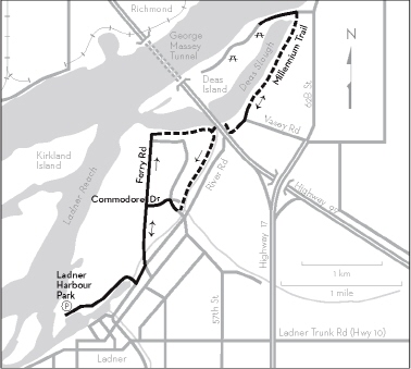
KM THE ROUTE
0.0 Ladner Harbour Park. Walking trails, birdwatching, fishboats and pleasure boats in the channel.
0.7 Left on River Road.
1.1 Left on Ferry Road at the stop sign.
2.7 Straight ahead at the roundabout. Pass the boatyard and turn left beside the Rusty Anchor Pub. Turn right opposite the pub entrance onto the gravel path alongside the marina.
3.7 Walk your bike across the bridge opposite the Millennium Trail plaque. Use caution as you cycle through the underpass beneath Hwy 99. Follow the trail and continue on the paved road past the Riverhouse Restaurant and condominiums.
4.5 At the road’s end, go through the barrier onto the dyke. Along Deas Slough, watch for herons, diving birds, hawks, eagles, rowing skiffs.
5.8 Left onto Deas Island Regional Park access road.
6.2 Riverside picnic tables, toilets, viewing tower, heritage buildings, trail maps available at the information kiosk.
6.2 From Deas Island retrace your outward route through the Hwy 99 underpass.
8.7 Turn left at the Millennium Trail plaque and follow the gravel track bordering the golf course. Continue to the end, keeping the school on your right.
9.8 Right on Admiral Boulevard.
9.9 Left on Commodore Drive at the traffic light.
10.3 Left on Ferry Road.
11.1 Right on River Road.
11.5 Right on McNeeley’s Way.
12.2 Ladner Harbour Park.