Delta
. . . . .
| ROUND TRIP | 20.9 km (13 miles) |
| TERRAIN | Paved roads and unpaved dyke path; flat |
| TRAFFIC VOLUME | Low, moderate on River Road West |
| ALLOW | 2 ½ to 3 ½ hours |
| HIGHLIGHTS | Ocean and mountain views, Canoe Passage, tidal marsh |
| PICNIC SPOT | Below the dyke path after 10.5 km |
| STARTING POINT | Ladner Leisure Centre on Clarence Taylor Crescent |
| HOW TO GET THERE | BY CAR: From Vancouver, leave Hwy 99 south of the Massey Tunnel at exit 28. Follow Hwy 17 south for 1.5 km and turn right on Ladner Trunk Road (Hwy 10). Turn left at the next traffic light onto Harvest Drive and left again on Clarence Taylor Crescent. The Ladner Leisure Centre is on the left after the bend. From other directions, use Ladner Trunk Road (Hwy 10) to the traffic light at Harvest Drive. |
| BY TRANSIT: Take the bus to Ladner Exchange or catch the bike shuttle to the south end of the George Massey Tunnel and ride to the starting point. | |
| WHEN TO GO | View colourful marsh plants in September and October. |
| CONNECTS WITH | Westham Island |
AN EASY run through the farmland south of Ladner comes to a halt at the causeway leading to Roberts Bank Superport, where long coal trains from the Kootenays and Alberta wait to be unloaded onto freighters bound for Pacific Rim countries.
Beyond the gate onto the dyke, the scene changes. Cycling the countrified dyke between fields and tidal marsh, you share the domain of herons, hawks and waterfowl. In winter, swans and snow geese can often be seen at the water’s edge. Take binoculars. In late summer, carry a container for blackberries. Driftwood and sheltering bushes provide a picnic spot below the dyke, with a view across the Strait of Georgia to Vancouver Island. As you round Brunswick Point, look across the cattail marsh for some old pilings—they are the remains of one of the earliest salmon canneries in Delta.
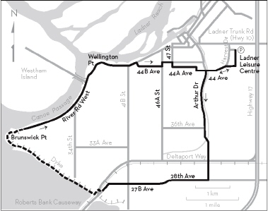
KM THE ROUTE
0.0 Ladner Leisure Centre parking lot. Left on Clarence Taylor Crescent.
0.3 Right on Mountain View Boulevard.
0.6 Left on Harvest Drive, which becomes 44th Avenue.
1.7 Left on Arthur Drive at the traffic light. Arthur Drive becomes 53rd Street.
4.3 Cross Deltaport Way on the overpass.
5.0 Right on 28th Avenue, which becomes 27B Avenue.
7.4 Cross 41B Street and continue on 27B Avenue. Roberts Bank coal port ahead.
8.2 Go right across the railway tracks at the stop sign just after the bend. Caution: Trains are moved electronically, without warning.
Follow the dirt track to the left.
8.5 Right onto the dyke at the gate. Suitable lunch spots can be found a short distance north of the farm, where a path leads to a picnic table below the dyke and to driftwood along the foreshore.
11.9 After rounding Brunswick Point, you can descend to River Road West at the gate.
15.4 Wellington Point is on your left. View of Canoe Passage and Westham and Barber Islands. Watch for seals and sea lions feeding around the cannery.
17.0 Right on Church Street then left on 44B Avenue.
17.6 Left on 46A Street then immediately right on 45th Avenue.
17.8 Right on 47th Street.
18.0 Left on 44A Avenue.
18.7 Right on 50th Street.
18.8 Left on 44th Avenue.
19.3 Cross Arthur Drive at the traffic light and continue on 44th Avenue.
20.4 Right on Mountain View Boulevard.
20.7 Left on Clarence Taylor Crescent.
20.9 Ladner Leisure Centre parking lot.