Pitt Meadows/Fraser Valley Regional District
. . . . .
| ROUND TRIP | 27.1 km (17 miles) |
| TERRAIN | Paved roads and gravel dyke; flat |
| TRAFFIC VOLUME | Low |
| ALLOW | 2 ½ to 3 ½ hours |
| HIGHLIGHTS | Pitt Polder, Pitt Lake, mountain views, osprey nests, Alouette River |
| PICNIC SPOT | Grant Narrows Regional Park at 13.6 km |
| STARTING POINT | Menzies Crossing parking area on Harris Road, south of Alouette River bridge |
| HOW TO GET THERE | BY CAR: From Lougheed Highway (Hwy 7), turn left on Dewdney Trunk Road just east of Pitt River Bridge. Turn left again on Harris Road and drive 2 km to Alouette River bridge. |
| BY TRANSIT: Catch the West Coast Express to Pitt Meadows Station or take the bus to Harris Road at Dewdney Trunk Road and ride to the starting point. | |
| WHEN TO GO | Watch for young osprey on the nests in May and June; buy local blueberries in August. |
| CONNECTS WITH | Pitt River Regional Greenway, Alouette River |
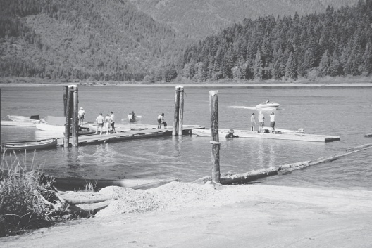
Grant Narrows Regional Park
NATURE TAMED and untamed could be the theme for this ride. First, the polder: land wrested from the flood plain by human ingenuity. As early as 1911, attempts were made to dyke the area, all ending in flooding or financial disaster. It took Dutch immigrant engineers (and Dutch investment) to overcome the problems. During the 1950s, the first farmsteads were laid out, each with a silo, barn and milking parlour and tenanted by a Dutch farmer.
The marshy northern half of the polder is designated as a Wildlife Management Area and extends to Pitt Lake. From the shores of the 26-kilometre-long lake, the Coast Mountains rise dramatically, often bearing weighty clouds on their shoulders. To the north, from its headwaters on a snowy peak in Garibaldi Park, the upper Pitt River flows through the lake and out again through Grant Narrows, fighting the tides on its way to join the Fraser River.
It is worth cycling out along the Pitt Lake dyke for a view of the lake and marsh. Keep a look out for ospreys—their nests have been built on top of the pilings at the edge of the foreshore.
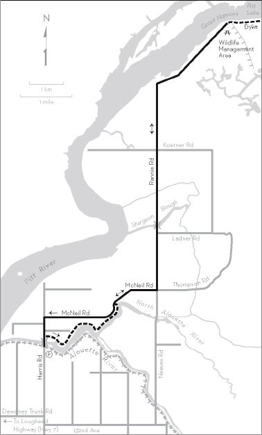
KM THE ROUTE
0.0 Menzies Crossing parking area. Right (north) on Harris Road and over the bridge.
0.2 Right onto the dyke path on the north side of Alouette River.
3.2 Leave the dyke and continue to the right on McNeil Road. Blueberry farms and tree nurseries.
4.7 Left on Rannie Road.
6.5 Cross the bridge over Sturgeon Slough.
13.6 Grant Narrows Regional Park at Pitt Lake. Picnic tables, toilets, concession, canoe rental, walking trails.
OPTION: Cycle Pitt Lake dyke for wider views. The inner dykes are for walkers only.
13.6 Retrace your outward route on Rannie Road.
22.5 Right on McNeil Road.
26.3 Left on Harris Road.
27.1 Left into Menzies Crossing parking area.