Langley
. . . . .
| ROUND TRIP | 10 km (6 ¼ miles) or more |
| TERRAIN | Paved road; flat |
| TRAFFIC VOLUME | Very low |
| ALLOW | 1 to 1 ½ hours |
| HIGHLIGHTS | Ferry crossing, farms, river and mountain views, Robert Point Regional Park |
| PICNIC SPOT | Robert Point at 8.9 km |
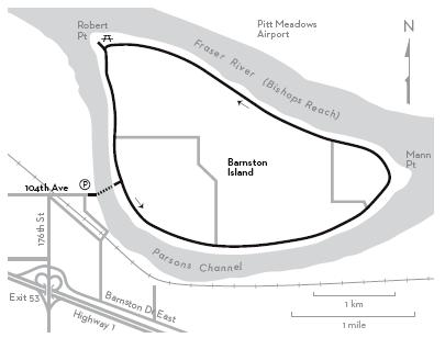
| STARTING POINT | Ferry slip at the end of 104th Avenue (Hjorth Road) |
| HOW TO GET THERE | BY CAR: Leave Hwy 1, east of the Port Mann Bridge, at exit 50 and drive north on 160th Street. Turn right on 104th Avenue and drive for about 3.5 km to the parking lot at the ferry slip. |
| BY TRANSIT: Take the bus to 104th Avenue at 168th Street and ride to the starting point. | |
| WHEN TO GO | Look for wild roses in bloom in June. |
SOMETIMES YOU want a safe, undemanding ride that even little legs and wheels can manage. Barnston Island, lying in the Fraser River opposite Surrey Bend, is a favourite with cycling families. Leave your car at the slip; a free ferry ride—sound your horn to summon the boat—is part of the fun.
The paved road you cycle on is the top of a dyke encircling the entire island. Inland, the landscape is a patchwork of fields, while the river beyond the dyke provides a changing scene. In Parsons Channel, fishboats, barges and float planes go about their business to the music of a nearby sawmill. After rounding Mann Point at the island’s eastern end, you enter Bishops Reach. Paths lead down to the river, where you can look across the log booms to Pitt Meadows Airport on the opposite shore and upstream to Golden Ears Bridge.
All too soon, you reach Robert Point at the northwest tip of the island. Follow the loop trail to the beach and picnic site. A short homestretch, enhanced by a view of Mount Baker, brings you back to the ferry stage. Not long enough? Go round again.
KM THE ROUTE
0.0 Disembark from the ferry and go right to begin a counterclockwise circuit. River traffic in Parsons Channel.
4.3 Mann Point. Wild roses in summer. View upstream to Golden Ears.
8.9 Robert Point Regional Park with picnic tables, toilets. View downstream toward the Port Mann Bridge.
10.0 Ferry slip.