Langley
. . . . .
| ROUND TRIP | 26.7 km (16 ¾ miles) |
| TERRAIN | Paved roads and unpaved paths; rolling hills |
| TRAFFIC VOLUME | Low to moderate; may be busy on 16th Avenue |
| ALLOW | 2 ½ to 3 ½ hours |
| HIGHLIGHTS | Country roads among farms and stables; Campbell Valley Regional Park: visitor centre, Annand/Rowlatt farmhouse, Lochiel school- |
| house, wildlife garden; Noel Booth Park | |
| PICNIC SPOT | Campbell Valley Regional Park (south entrance) at 13.8 km |
| STARTING POINT | Roadside parking at Noel Booth Community Park on 36th Avenue, or in the parking lot |
| HOW TO GET THERE | BY CAR: From Fraser Highway (Hwy 1A) or Hwy 1 exit 58, drive south on 200th Street. Turn left (east) on 36th Avenue. |
| BY TRANSIT: Take the bus to 200th Street at 36th Avenue and ride to the starting point. | |
| WHEN TO GO | Late August to pick blackberries in the park. |
OUR ROUTE jogs southward in easy stages, taking you through quiet residential neighbourhoods and past eclectic hobby farms and horse paddocks.
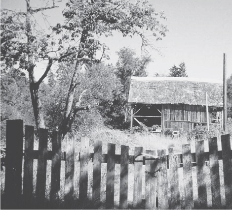
Here and there among Langley’s gentle hills stand old barns, split-rail fences and skeletal remnants of orchards—memorials to the region’s pioneer farmers. One of the earliest settlers in this valley was Alexander Annand, whose restored 1898 homestead stands in Campbell Valley Regional Park. Nearby, the one-room Lochiel schoolhouse has come to rest in the park after having been moved three times and having done duty as a community hall.
Old barn near Langley
The park’s uplands and wetlands surrounding the Campbell River provide habitat for many varied animals, birds and plants. Cycling is not permitted in the park, but nature lovers can lock their bikes to the cycle rack and explore on foot. The Campbell River (more correctly, the Little Campbell River) takes a northward swing through the valley, thereby meeting your path once again before resuming its westward journey to Semiahmoo Bay.
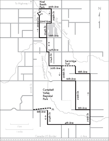
KM THE ROUTE
0.0 Noel Booth Community Park. East on 36th Avenue.
0.8 Right on 205th Street.
1.6 Right on 32nd Avenue.
1.8 Left on 204th Street. Lakes are visible on the left.
3.4 Jog left on 24th Avenue.
3.6 Right on 204A Street.
Left on 20th Avenue.
5.1 Right on 208th Street.
5.9 Left on 16th Avenue. Busy main road.
6.7 Right on 212th Street. Go uphill, then down a longer hill.
8.4 Left on 8th Avenue.
9.2 Right on 216th Street. Cross Little Campbell River.
10.0 Right on 4th Avenue. Go gradually uphill.
Right on 204th Street.
Left on 8th Avenue.
13.4 Right to Campbell Valley Regional Park. Follow the driveway to the second parking lot.
13.8 Information kiosk; picnic tables to right, past washroom building; visitor centre; wildlife garden; walking trails. Cycling is not permitted in the park.
14.3 Left on 8th Avenue at the park entrance and retrace your inward route via 204th Street and 4th Avenue.
17.6 Left on 216th Street. Hills.
20.4 Left on 18th Avenue.
21.2 Right on 212th Street.
21.5 Left on 20th Avenue. Where the pavement ends, continue through the gate onto Fernridge Trail.
22.3 Cross 208th Street and continue west on 20th Avenue.
22.9 Right on 204A Street.
23.7 Left on 24th Avenue.
23.8 Right on 204th Street immediately before the bridge over Campbell River.
24.6 Left on 28th Avenue.
25.0 Right on 202nd Street. Continue beyond “No Exit” sign.
26.2 Where 202nd Street bends right, leave the pavement and follow the path beyond the concrete barriers. Keeping the fenced tennis courts on your right, cross a parking lot and road and enter Noel Booth Park through the gate opposite. Continue past the baseball diamond and turn right across the bridge over Anderson Creek. Follow the gravel path to the left, skirting the sports field.
26.7 Noel Booth Community Park parking lot.