Langley/Abbotsford
. . . . .
| ROUND TRIP | 25.3 km (16 miles) |
| TERRAIN | Paved roads and gravel trail; some flat, some rolling hills |
| TRAFFIC VOLUME | Moderate; heavy around Aldergrove. Gravel trucks use 8th Avenue and Lefeuvre Road on weekdays. |
| ALLOW | 2 ½ to 3 ½ hours |
| HIGHLIGHTS | Roadside berry stalls in season, Aldergrove Lake Regional Park, views of Mount Baker and the Golden Ears |
| PICNIC SPOT | Aldergrove Lake Regional Park at 16.7 km |
| STARTING POINT | Aldergrove City Park on 32nd Avenue |
| HOW TO GET THERE | BY CAR: From Fraser Highway (Hwy 1A), turn north on 264th Street (Hwy 13), then immediately right on 32nd Avenue. Enter the park after 1.5 km, immediately after passing the sports field. |
| BY TRANSIT: Take the bus to Fraser Highway (Hwy 1A) at 272nd Street and ride to the starting point. | |
| WHEN TO GO | Attend the Aldergrove Fall Fair in September; sample local berries in June. |
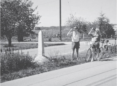
Borderline refreshments
ALDERGROVE, A town known for tasty German sausages, also boasts a telephone museum and one of the oldest agricultural fairs in B.C. Leaving its small city park, you bowl along the hills and dales of southeastern Langley, passing tree nurseries and berry farms interspersed with paddocks and stables—evidence of Langley Township’s claim to be “The Horse Capital of B.C.”
A short stretch along the 49th parallel brings you to Aldergrove Lake Regional Park. This area is rich in gravel deposits left by retreating glaciers; the park’s lake and ponds have been created from reclaimed gravel pits—work that is still going on. Unfortunately, the popular swimming lake, which was artificially created, has fallen into disrepair and is in danger of being permanently closed.
Much of the park is wooded and criss-crossed with a network of walking and equestrian trails, some of which are now open to cyclists. Park maps are available at the lake. Your route includes a stretch of the multi-use Rock’n Horse Trail, playfully named for a giant glacial erratic boulder along the way. This section is manageable by most bicycles, but if yours is a light-framed road bike, you may prefer to complete the ride on paved roads by continuing east from the park entrance on 8th Avenue to rejoin the described route at Lefeuvre Road. In this case, your distances from the intersection with Lefeuvre will be approximately 2 kilometres shorter than those given.
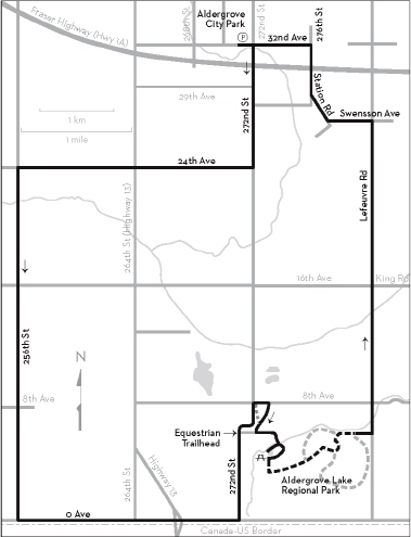
KM THE ROUTE
0.0 Aldergrove City Park parking lot. Left (east) on 32nd Avenue. The telephone museum is on the corner of 271st Street.
0.2 Right on 272nd Street.
1.9 Right on 24th Avenue.
5.2 Left on 256th Street. Undulating road. Pass several stables.
10.0 Left on 0 Avenue. This road runs along the Canada– U.S. border. There are raspberry farms and nurseries on your left. Continue to where 0 Avenue bends left to cross Hwy 13.
12.2 Cross Hwy 13 north of the border crossing and continue on 0 Avenue. Boundary Road in the U.S. runs parallel on your right.
13.6 Left on 272nd Street. Your climb is gradual, becoming steeper after the bend. Pass Equestrian Trailhead.
15.5 Right on 8th Avenue, then right at the park entrance 200 metres ahead. Follow the park access road, pass a sheltered picnic area in the field and turn right after the bridge into the main parking lot.
16.7 Aldergrove Lake. Picnic tables, bike rack, toilets, trail maps. Turn left past the lakeside picnic tables and follow the shared trail until you come to the signposted Rock’n Horse Trail.
16.9 Left on Rock’n Horse Trail. Ups and downs. Cyclists give way to pedestrians and horseback riders.
17.5 Keep right where the trail forks.
17.8 Left at the T-junction after a sharp rise. (Right leads to a good viewpoint in 50 m.)
17.9 Keep right on Rock’n Horse Trail at the next junction. Continue east along the avenue of alders, Pepin Brook visible below. Turn left through the parking lot to Lefeuvre Road.
18.4 Left on Lefeuvre Road. Hills. Cross Huntingdon Road and King Road.
22.6 Left on Swensson Avenue.
23.2 Right on Station Road.
23.6 Bear right on 276th Street and cross Fraser Highway (Hwy 1A) at the traffic light.
24.3 Left on 32nd Avenue.
25.3 Right into Aldergrove City Park.