Fraser Valley Regional District
. . . . .
| ROUND TRIP | 25.4 km (16 miles) |
| TERRAIN | Paved roads and short unpaved trail; some hills |
| TRAFFIC VOLUME | Low, possibly moderate on Sylvester Road |
| ALLOW | 2 ½ to 3 ½ hours |
| HIGHLIGHTS | Farmlands and mountain views, Allen Lake, Cascade Creek and waterfall |
| PICNIC SPOT | Cascade Falls Regional Park at 11.4 km |
| STARTING POINT | Hatzic Prairie Community Hall on Farms Road |
| HOW TO GET THERE | BY CAR: From Lougheed Highway (Hwy 7) about 6.5 km east of Mission, turn left on Sylvester Road, then left on Farms Road. The community hall is at the junction of Farms and Dale Road. |
| BY TRANSIT: There is no viable transit option at this time. | |
| WHEN TO GO | Watch the cascades during spring run-off in June. |
EXTENDING NORTHWARD from Hatzic Lake is a narrow valley criss-crossed by numerous creeks born in the mountain ramparts to the east. The route described takes you from the gentle farmlands of Hatzic Prairie to the sterner region through which Cascade Creek makes its helter-skelter descent. From our suggested picnic spot beside the creek, a foot trail climbs 90 metres to the spectacular double falls—an approach that is more in keeping with the spirit of the cascades than the gravel vehicle road.
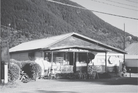
Hatzic Prairie Market
On your return route to the prairie, Stave Lake Road provides a pleasing descent before passing through a quaintly rustic neighbourhood tucked against the western hillside. Rock climbers are often to be seen tackling the bluffs along here.
Be warned that a sudden thunderstorm in the Hatzic area is not uncommon, and while you may enjoy the sight and sound as it rolls around the surrounding mountains you’d be wise to keep rainwear handy on this outing.
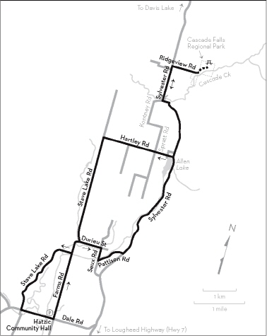
KM THE ROUTE
0.0 Hatzic Prairie Community Hall parking lot. Left (north) on Farms Road.
2.5 Straight ahead on Durieu Street after the bend.
3.2 Right on Seux Road. Straight ahead is a “No Thru Road” sign.
3.6 Left on Pattison Road.
4.6 Left on Sylvester Road. This is a narrow, winding road with ups and downs.
Pass Allen Lake on your left. There is no public access to the water.
10.2 Cross the bridge over Cascade Creek.
10.6 Right on Ridgeview Road to Cascade Falls Regional Park.
11.4 Gate. The park is open year-round; you may walk in when the gate is closed (October to May). The gravel road continues to the top of the falls, but a gated track on the right leads to a picnic spot beside the creek, from which the cascades can be reached by a foot trail. Cycling is not allowed on the park trails.
11.4 Return on Ridgeview Road.
12.2 Left on Sylvester Road.
15.3 Right on Hartley Road. Steep hill.
17.6 Left on Stave Lake Road. Ups and downs.
20.9 Keep right on Stave Lake Road at the bend where Durieu Street goes left.
21.4 Right to stay on Stave Lake Road. Watch closely for this turning, which is immediately before the bridge. Narrow, winding road.
24.2 Left on Dale Road.
25.4 Hatzic Prairie Community Hall at the junction with Farms Road. Refreshments available at Hatzic Prairie Market opposite.