Fraser River Regional District
. . . . .
| ROUND TRIP | 22 km (13 ¾ miles) |
| TERRAIN | Paved roads and gravel road; flat |
| TRAFFIC VOLUME | Low, except for a short stretch of Lougheed Highway |
| ALLOW | 1 ½ to 2 ½ hours |
| HIGHLIGHTS | Quiet country roads, waterfowl in Nicomen Slough, Quaamitch Slough, old store in Deroche |
| STARTING POINT | On North Nicomen Road in Deroche. Park beside the railway tracks opposite Deroche Community Hall. |
| HOW TO GET THERE | BY CAR: Drive east from Mission on Lougheed Highway (Hwy 7) about 21 km to Deroche. Turn left onto North Nicomen Road immediately after the bridge. |
| BY TRANSIT: There is no viable transit option at this time. | |
| WHEN TO GO | May and June to see geese and goslings in the slough; winter to view bald eagles. |
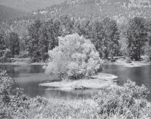
Nicomen Slough
NICOMEN ISLAND is the largest of several islands encompassed by the Fraser River and Nicomen Slough. Despite being bisected by the Lougheed Highway, the island remains a sleepy backwater where the cyclist can pedal beside the wide, slow-moving slough and among the farms and berry fields. A dyke protects the island from encroachment by the Fraser River, but as its path is fairly rough and gated at frequent intervals, the winding Nicomen Island Trunk Road affords a more comfortable ride.
We have not yet found the perfect picnic spot on Nicomen Island; instead, we load our bikes back onto the car and drive 15 kilometres east on Lougheed Highway (Hwy 7) to Kilby Provincial Park on Harrison Bay. Here, there are picnic tables behind the Kilby General Store Museum or a homestyle lunch in the Harrison River Tea Room. Kilby is not large enough for a grand tour, but you can cycle to the end of Kilby Road and back, or through the tiny settlement to the bay, where the Harrison River gathers itself before entering the narrow channel to the Fraser.
An alternative to the lazy outing described is to combine the Nicomen Island route with the Dewdney dyke. For this you must brave the Lougheed Highway west of the Nicomen Island Trunk Road turnaround point, cross the bridge over Nicomen Slough and immediately turn left onto River Road South. From there, another 9 kilometres of dyke and farm roads are yours to explore.
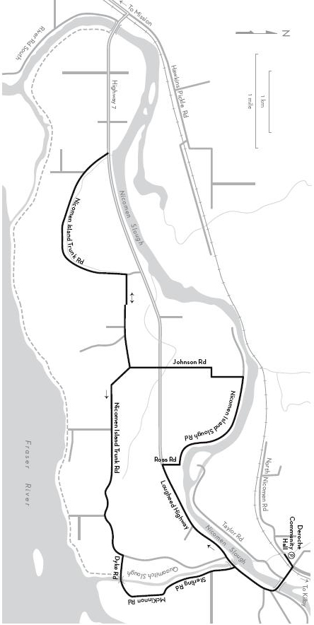
KM THE ROUTE
0.0 Deroche Community Hall. Right onto Lougheed Highway and cross the bridge over Nicomen Slough. Continue west on the highway—for a better view of the slough you can cycle on the dyke top, but return to the pavement before reaching the gate to private property.
3.5 Right on Ross Road, which becomes Nicomen Island Slough Road at the bend.
6.0 Left on Johnson Road.
Cross Lougheed Highway.
8.1 Right on Nicomen Island Trunk Road.
11.1 Turnaround point at the junction with Lougheed Highway. Retrace your route on Nicomen Island Trunk Road to avoid using the busy highway.
14.1 Johnson Road on left. Stay right to continue east on Nicomen Island Trunk Road.
19.2 Right on Dyke Road. Cross Quaamitch Slough.
19.9 Left on McKinnon Road, which becomes Sterling Road.
21.7 Right on Lougheed Highway.
Left on North Nicomen Road after the bridge.
22.0 Deroche Community Hall.