Abbotsford
. . . . .
| ROUND TRIP | 35.2 km (22 miles) |
| TERRAIN | Paved roads and unpaved trail (a hybrid bike is best for this); some hills |
| TRAFFIC VOLUME | Low, except moderate on 58th Avenue |
| ALLOW | 3 ½ to 4 ½ hours |
| HIGHLIGHTS | Quiet country roads, daffodil fields, Fraser River, mountain views, Matsqui Trail |
| PICNIC SPOT | Riverbank at Glenmore Trailhead at 18.3 km |
| STARTING POINT | The west side of 264th Street, immediately north of the Hwy 1 overpass |
| HOW TO GET THERE | BY CAR: Leave Hwy 1 at exit 73 and drive north on 264th Street to the north end of the overpass. Park on the wide shoulder. |
| BY TRANSIT: There is no viable transit option at this time. | |
| WHEN TO GO | March and April to see the daffodils. |
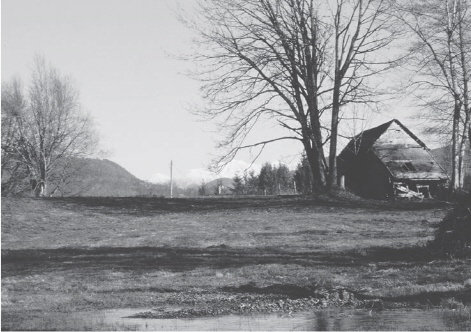
View from Matsqui Trail West
SOME ROLLICKING ups and downs take you over the rolling Bradner plateau, which is famous for its fields of tulips and daffodils. Flowers have been grown here since 1914, when the Fatkin family planted the first bulbs. A few years later, the first Bradner Flower Show was held—an annual festival that continues to this day, around Easter.
After a plunge down to prairie level, you reach the Fraser River at Glenmore Trailhead, where a 3.5-kilometre extension of the Matsqui Trail (also the Trans Canada Trail) heads west through Matsqui First Nation reserve lands. This is a challenging trail with many twists and turns and some stretches of loose gravel. Ride carefully and be prepared to give way to hikers and horse riders.
Returning to paved roads, you stay high above the Fraser River through Mount Lehman, enjoying fine views of the mountains north of Mission before picking up your outward route opposite Bradner General Store.
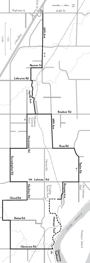
KM THE ROUTE
0.0 264th Street immediately north of the Hwy 1 overpass. East on 56th Avenue. This is a wide road through the industrial area.
2.8 Right on Baynes Street.
3.3 Left on Myrtle Avenue.
3.9 Left on Lefeuvre Road, then immediately right to continue on Myrtle. Caution: There is a steep, winding descent followed by a right-hand bend and a sudden uphill.
5.7 Right on Bradner Road. The Bradner General Store is opposite.
6.2 Left on Haverman Road. Daffodil fields.
7.9 Right on Ross Road.
8.7 Left on Townshipline Road. Daffodil fields.
10.3 Left on Mount Lehman Road.
11.2 Right on Hawkins Road.
11.9 Right on Olund Road. There is a view of Matsqui Prairie before the descent.
Left on Bates Road.
14.6 Right on Townshipline Road.
16.2 Left on Glenmore Road. Cross Harris Road.
18.3 Cross the railway and ride to the end of Glenmore. (Do not take the gravel road to the left.) To the right, a short distance beyond the gate onto the dyke, some rocks provide a good picnic spot with a view across the Fraser River to Matsqui Island.
18.3 To continue, backtrack to the sign “Matsqui First Nation Reserve Lands” at the end of Glenmore. Go west on the Trans Canada Trail and follow signs for 3.5 km. This is a multi-use trail—please ride carefully and give way to walkers and horse riders.
21.7 Keep straight ahead where a path branches left to Douglas Taylor Park parking lot.
21.8 Right at the T-junction onto the wood-chip trail. The trail rises steeply to join Olund Road.
Left at the T-junction. Cross the railway tracks and keep left on Burgess Avenue.
23.1 Right on Mount Lehman Road.
24.0 Left on Taylor Road. Views of mountains to the north.
25.6 Left on Ross Road.
27.2 Right on 58th Avenue. Busy road.
28.8 Left on Bradner Road.
29.5 Right on Myrtle Avenue opposite Bradner General Store.
Retrace your outward route, jogging left on Lefeuvre Road to continue on Myrtle Avenue.
32.4 Right on Baynes Street.
Left on 56th Avenue.
35.2 Left on 264th Street to parking area.