Chilliwack
. . . . .
| ROUND TRIP | 33.6 km (21 miles) |
| TERRAIN | Paved roads; flat |
| TRAFFIC VOLUME | Low |
| ALLOW | 3 to 4 hours |
| HIGHLIGHTS | Camp Slough, Hope Slough, winding roads, farms, nut groves, mountain views, heritage building |
| PICNIC SPOT | Kinsmen Park on Hope River Road at 19.7 km |
| STARTING POINT | Rosedale Community Park on Old Yale Road |
| HOW TO GET THERE | BY CAR: Leave Hwy 1 at exit 135 and drive north on Agassiz-Rosedale Highway (Hwy 9). Turn left (west) on Yale Road East to Rosedale. The park is at the junction of Yale Road East and Old Yale Road. |
| BY TRANSIT: If you are already in Chilliwack, take the Chilliwack/Agassiz-Harrison Transit Route 11: Agassiz-Harrison, get off on Old Yale Road at McGrath Road and ride to the starting point. | |
| WHEN TO GO | June or July for a shady ride and to see water lilies in the sloughs. |
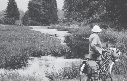
Camp Slough
BETWEEN ROSEDALE and Chilliwack, the Fraser River flood plain is laced with sloughs that effectively carve the land into islands. Cycling is the perfect mode of travel for exploring these meandering waterways. There’s time to watch the herons fishing and the ducks dabbling in green, willow-fringed Camp Slough and to notice the overhanging walnut trees and the huge old maples. The Fraser River dykes, too, offer good cycling, but for comfort and a variety of scenery, our route follows the paved roads in their wanderings over Rosebank, Windermere and Fairfield Islands.
Having reached the more serious Hope River Road and rested on the banks of Hope Slough, you can enjoy an easy run back to Rosedale among a fair sampling of Chilliwack’s nine hundred farms. Mount Cheam and its sister peaks dominate the scene.
Several historic buildings lie along your route. On Jesperson Road, look for Jesperson House, built in 1912. Rosedale United Church on Yale Road East was built in 1908 for a cost of $125; its original steeple bell is still in use.
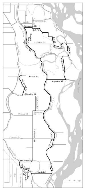
KM THE ROUTE
0.0 Rosedale Community Park. Right (north) on Old Yale Road.
0.8 Left on Bustin Road.
2.3 Left on Ferry Road. (Right goes to Ferry Island Provincial Park and Cheam First Nation reserve.) Ferry Road becomes Camp River Road. After passing Camp River Community Hall, watch for a row of heritage maple trees. Camp Slough is on your right.
9.9 Right on Jesperson Road. Cross Camp Slough.
11.3 Left on Kitchen Hall Road.
13.0 Right on Kitchen Road.
13.4 Left on Ballam Road.
14.3 Keep left on McSween Road where Ballam Road turns right.
15.7 Keep straight ahead on Bell Road. Enter the residential area.
Jog right on Brice Road, then
18.2 Left on Wedgewood Drive.
18.8 Left on Hope River Road.
19.7 Kinsmen Hall and park are on the right. Picnic tables beside Hope Slough.
19.7 Continue east on Hope River Road.
21.4 Right on Camp River Road. Cross Gravelly Slough.
22.8 Right on Reeves Road.
24.8 Keep straight ahead on McConnell Road where Reeves bends right to meet Yale Road East.
26.4 Left on Gillanders Road.
Right on Castleman Road at the bend.
28.4 Right on Standeven Road.
Left on Castleman Road at the bend.
32.3 Right on McGrath Road.
33.1 Left on Yale Road East.
33.6 Left on Old Yale Road to Rosedale Community Park.