Chilliwack/Whatcom County, U.S.
. . . . .
| ROUND TRIP | 35.2 km (22 miles) |
| TERRAIN | Paved roads; mostly flat, some gentle hills |
| TRAFFIC VOLUME | Low, except for Huntingdon–Sumas border crossing |
| ALLOW | 3 to 4 hours |
| HIGHLIGHTS | Farms, orchards, mountain views, Sumas River, Nooksack City Park |
| PICNIC SPOT | Nooksack City Park at 17.6 km |
| STARTING POINT | Vicinity of Upper Sumas Elementary School on Whatcom Road |
| HOW TO GET THERE | BY CAR: Leave Hwy 1 at exit 95 and drive south on Whatcom Road to Vye Road. The school is on the corner. Please be considerate if parking during school hours—there is plenty of space at the roadside. |
| BY TRANSIT: If you are already in Abbotsford, take the Central Valley Transit Route 2: Bluejay–Huntingdon GoLine bus to Sumas Way (Hwy 11) at Vye Road and ride to the starting point (or get off at 4th Avenue and B Street and begin your ride at the border). | |
| WHEN TO GO | See cattle in the fields and activity on the farms in July and August. |
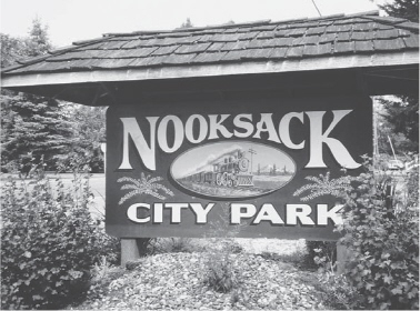
City Park sign
AS THIS ride crosses the border, carry the required identification and medical insurance. Along this route, which begins on Sumas Prairie and continues through the lush farmland in the shadow of Sumas Mountain in Whatcom County, you will cross the Sumas River several times. The wandering watercourse, however, is easily overlooked as it slips along between grassy banks and overhanging bushes. There are sequestered corners where gardens flourish around well-kept homes and wide views across fields of corn to the foothills of Mount Baker.
To the drivers of cars, trucks and milk tankers on State Route 9, the town of Nooksack is passed in a flash, but as you cycle by you’ll notice the fine school on the hill, the homely post office building and the handsome sign announcing the city park. This sliver of land between road and railway offers picnic tables beneath a stand of beautiful Douglas-firs and maples.
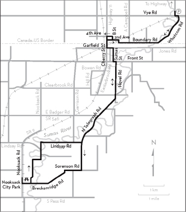
KM THE ROUTE
0.0 Upper Sumas Elementary School. Left (east) on Vye Road.
0.2 Right on Whatcom Road and cross the railway. The Sumas River is on your right. Whatcom Road becomes Boundary Road, then changes to 2nd Avenue at the bend by the lumberyard.
5.1 Right on B Street.
5.3 Left on 4th Avenue.
5.4 Left on Sumas Way (Hwy 11) to U.S. Customs. Enter the building and check in as a pedestrian before walking your bicycle past the booth.
Proceed south through Sumas on Cherry Street.
6.0 Left on Garfield Street.
6.1 Right on Sumas Street. The city park is on your right.
6.9 Left on Front Street.
7.2 Right on Hovel Road.
9.2 Straight ahead on North Telegraph Road where Morgan Road intersects. You have glimpses of the Sumas River as you ride past dairy farms, eventually gaining height.
14.2 Right on Sorenson Road.
15.0 Left on Breckenridge Road. Nooksack Elementary School is on your left. After a gradual descent, the road becomes Madison Street as it enters Nooksack.
17.4 Cross the railway tracks, then immediately go right on Nooksack Road (SR 9).
17.6 Right into Nooksack City Park. Picnic tables, toilets.
17.6 Backtrack left on Nooksack Road.
17.7 Left on Madison Street.
18.2 Left on 4th Street (Gilles Road).
20.5 After passing Alm Road, stay straight ahead where Lindsay Road (unmarked) branches left.
23.0 Left on North Telegraph Road, which becomes Hovel Road.
28.4 Left on Front Street.
28.7 Right on Sumas Street.
29.5 Left on Garfield Street.
29.7 Right on Cherry Street and proceed through Canadian Customs.
30.2 Right on 2nd Avenue and retrace your outward route via Boundary Road and Whatcom Road.
35.0 Left on Vye Road after the railway tracks.
35.2 Right to Upper Sumas Elementary School.