The Rough Tor Triangle: A theory
Roy Goutté, author, amateur archaeologist and founding member of TimeSeekers
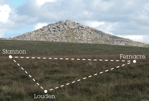
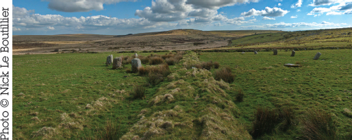
Nestling neatly in the shadow of Rough Tor on Bodmin is the stone circle of Fernacre. Just 2km (under 1¼ mile) to the west is Stannon circle, and 800m (½ mile) to the southeast of Stannon is the third in this triangle of large Cornish circles – Louden. All three were probably built in the late Neolithic, although a lack of accurate dating evidence in some Cornish circles is a problem. Within their settings they all feature a single, large, triangular upright made of granite. It is these iconic Cornish tri-stones and their possible meaning and connection to Rough Tor that I would like to concentrate on. The three circles have so much in common, and are so close together, that it doesn’t take much to figure out that they are likely to be contemporaneous, and possibly erected by the same people.
All are big by Cornish standards, made up of a large number of small stones. Stannon has around 70 in an irregular ring of straight sections, but originally there may have been 80 or more. Fernacre also has a large number of stones in its setting; Louden has fewer at 52, confirmed by our TimeSeekers volunteer clearance group in 2015. All three circles have been labelled as “ceremonial” in certain quarters, but I visualize ceremonial circles as displaying magnificent uprights in their settings, with a true look of grandeur. But that is not the case here. It almost seems that the builders used any size stone they could get their hands on. This suggests to me that each circle was a part of a larger design.
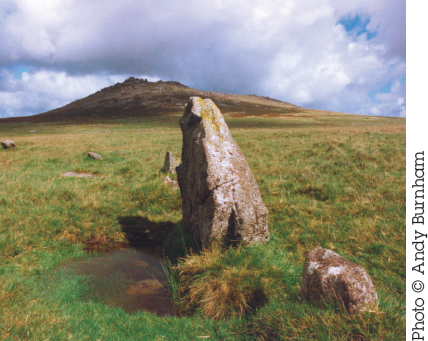
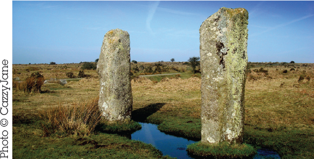
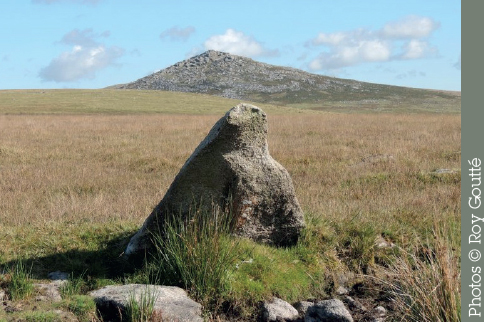
What is the meaning of the large tri-stones in these three settings? It was only when I was photographing the tri-stone of Louden circle with Rough Tor in the background, that their similarity in shape dawned on me. To my amazement, I witnessed the same at Stannon, and this made me wonder if the builders had replicated Rough Tor as best they could with a single tri-stone in their ring settings.
So, we have three large, irregular, similarly sized stone circles with similarly sized stones, all with a prominent tri-stone and all in close proximity. It would be easy to suggest that if the people of their time revered Rough Tor, then the tri-stones may have been chosen and placed in the circles as a focus of ceremonies.
Lines drawn between the three circles create a triangle that seems to mirror Rough Tor exactly
Where the tri-stones are positioned within each circle could also tell a speculative but interesting tale. Remarkably, the tri-stone of the circle to the east (Fernacre) is positioned due east in the setting, and the tri-stone of the circle to the west (Stannon) is positioned due west in the setting. To complete the set, the tri-stone of Louden, the southernmost circle, is due south in its setting. Why would all three circles have their individual tri-stones on the side of the triangle they themselves form in the landscape? Draw a direct line between those three circles and note that they form a scalene triangle (no equal sides) which “by chance” (?) just happens to be a mirror image of Rough Tor! So, is this, then, the intention of the designers, rather than the building of individual circles? Are the circles demarcation points where boundaries joined and possibly ceremonies took place – or is that just speculation on my part? On a map it can be seen that most signs of prehistoric activity in the area – cairns, hut circles and field systems – lie within this triangle formed by the three stone circles.
The tri-stone of Louden circle, with Rough Tor visible behind
MAP
FERNACRE
Stone Circle | Nearest Village: St Breward
Map: SX 1447 7998 | Sheets: E109 L200 | Lat: 50.58999N | Long: 4.62245W
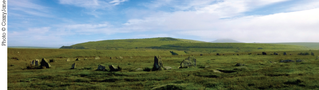
Fernacre stands on desolate, boggy moorland, with Rough Tor rising dramatically up to the north, Brown Willy to the east and Garrow Tor to the south. It is a very large circle, in keeping with others in the region, of c. 70 stones, 39 of which still stand. The circle is somewhat flattened, around 46 × 44m (151 × 144ft). The granite stones are sunk into the peat and would have been more impressive when first erected. Access is much easier since the building of a private track from Middle Moor Cross to Fernacre Farm. The circle is just north of the track, due south of Rough Tor peak. Park at the sign and walk to the circle.
“Close to the circle the road seems to veer off. Rather than walk around, I decided to walk directly to the stones across the moor. This turned out to be a bad idea. The moor suddenly felt like a magic carpet and gave way under my feet leaving me waist deep in a bog. Quite a scary experience!” Lee Price
STANNON
Stone Circle | Nearest Village: St Breward
Map: SX 1257 8002 | Sheets: E109 L200 | Lat: 50.58974N | Long: 4.64928W 
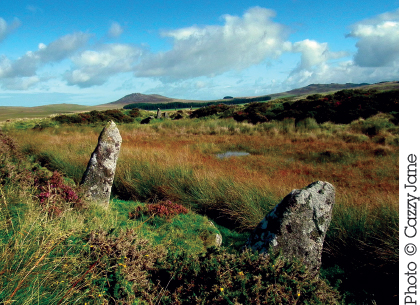
On a sloping site on open moorland, just south of Stannon china clay works (now a landscaped reservoir) and visible from the track, Stannon is a large (41.5m/136ft diameter), unevenly spaced circle with 77 remaining stones of local granite. Of these, 47 still stand. The stones are unusually small, none more than 1m (3ft 3in) in height, and in some parts of the circle are placed very close together. As with most circles on this part of Bodmin, the largest stone is triangular in shape.
Nearby | At SX 1321 7950, on the track that runs southwest from Fernacre and 823m (½ mile) ESE of Stannon circle, is Louden stone circle. Thanks to clearance by the TimeSeekers group, about 40 stones are visible of the 52 they found. Five are still standing, including the large tri-stone.
KING ARTHUR’S HALL
Rectangular Stone Enclosure | Nearest Village: St Breward
Map: SX 1297 7764 | Sheets: E109 L200 | Lat: 50.56849N | Long: 4.64244W
Many prehistoric sites are associated locally with King Arthur, but this must be the most unusual. This mysterious and unique enclosure resembles a rectangular henge, its banks surrounding a marshy interior. There’s an internal kerb of 56 visible stones, some taller than the bank and looking like chairs, giving the site its name. Clearance work revealed a retaining wall and a granite paved area, and suggested there might have originally been around 140 uprights. Various suggestions for the site’s purpose include use as a mortuary enclosure, or as a reservoir.
KING ARTHUR’S DOWNS Alt Names: Emblance Down NW, Leaze NW Stone Circles | Nearest Village: St Breward
Map: SX 1347 7751 | Sheets: E109 L200 | Lat: 50.56748N | Long: 4.63532W
Follow the track eastward from King Arthur’s Hall for about 500m (1,640ft) to find the remains of two adjacent, and very ruinous, circles. King Arthur’s Downs NW (so called, although it is actually on Emblance Downs) is in better condition, about 23m (75ft) in diameter, with eight stones remaining of which six are still standing, including two triangular-shaped stones. Two more fallen, perhaps displaced stones are to be found in the centre of the circle. There may have been 15 stones in the circle originally. It’s pretty wet here and the stones are often surrounded by large pools of water. The circle is sometimes described as “recently discovered” but was mentioned as early as 1860.
Just a few metres ESE, King Arthur’s Downs SE (at SX 1349 7750) is a similar size but even more badly damaged. Four stones remain standing, while four others have fallen. Those closest to the wall are the most obvious.
LEAZE
Stone Circle | Nearest Village: St Breward
Map: SX 1367 7729 | Sheets: E109 L200 | Lat: 50.56557N Long: 4.63239W
Some 300m (985ft) southeast from the King Arthur’s Downs circles is a ruinous stone circle on private land. The site is bisected by a wall and 10 of the original 28 stones are still standing, with six fallen. The small stones (average height of 1.1m/3½ft) are strikingly regular and pillar-like.
STRIPPLE STONES
Stone Circle & Henge | Nearest Village: Blisland
Map: SX 1435 7521 | Sheets: E109 L200 | Lat: 50.5471N | Long: 4.62176W
On private land on the southeast flank of Hawk’s Tor are the remains of an interesting circle and henge that in 2015 was partially restored with the help of Roy Goutté. A field boundary wall that ran through the site was removed, a buried fallen stone was exposed and three stones were re-erected, bringing the total number of stones standing to seven out of the 16 that survive from the original 28. The 44.8m (147ft) stone circle is set within a 68.3m (224ft) henge that has a 4.6m (15ft) gap, possibly an entrance, at the WSW. It has been speculated that the 3.7m (12ft) fallen stone within the circle was used as a backsight from which an observer, guided by three semi-circular bulges on the edges of the henge, would have viewed the major northern moonrise at the NNE, the equinoctial sunrise at the east, and May Day sunset at the WNW.

Nearby | At SX 1311 7501, 1.3km (just over ½ mile) west, are the Trippet Stones. Of an original 26 or 28, eight still stand in the 33m (108ft) circle, with five fallen. The stones are bigger than is usual in Cornwall, with the tallest 1.6m (5ft 3in). The name “Trippet” may refer to the delicate footwork of a dancer, indicating that here too merrymakers were turned to stone for breaking the Sabbath.
LESKERNICK
Megalithic Complex | Nearest Village: Altarnun
Map: SX 1871 7980 | Sheets: E109 L201 | Lat: 50.58971N | Long: 4.56252W
There’s plenty to see at Leskernick, on the saddle of land between Leskernick Hill and Beacon Hill. This beautiful setting on the eastern edge of Bodmin Moor is home to two stone circles, a long stone row and a large cairn, as well as settlements with numerous hut circles and enclosures on Leskernick Hill itself, which is enclosed by the region’s highest and most iconic hills.
LESKERNICK 1 (SE)
This 30m (98ft) circle (at SX 1882 7964) was discovered in 1973. Its 20 remaining stones, which include a triangular one to the west, are mostly over 1.2m (4ft) long and are all fallen. There are stumps of seven further stones. The volunteer group led by Roy Goutté has uncovered buried stones, including the broken remains of a central stone and a possible cist.
LESKERNICK 2 (NW)
First recorded in 1983 by Peter Herring, and cleared in 2016 by the TimeSeekers volunteers, the 21m (70ft) circle 368m (1,207ft) northwest of Leskernick I (at SX 1858 7992) has 23 stones. Some of the stones uncovered during the clearance were so deeply buried they had to be covered up again so as not to be a hazard for walkers and animals. It has been suggested that the stones, which are noticeably smaller than in the southeast circle (only four stones are more than 1.2m/4ft here) may have been erected to draw attention to the large, almost central “whale-backed” stone, which may or may not have once stood erect itself.
LESKERNICK STONE ROW
Another recently cleared site, the row of 56 stones runs west–east from close to a cairn situated between the two Leskernick stone circles (at SX 1870 7986). The row has been recorded as 317m (1,040ft) in length, with 0.2m (8in) tall stones spaced at 4.5m (15ft) intervals. There’s a stone setting or terminal at the western end, and the row appears to point directly at Brown Willy, Cornwall’s highest hill, looking splendid on the horizon. During clearance work it was suggested that there are in fact two rows here, on slightly different alignments, with the tinners’ gully (a relic of mining activity) dividing them. Stones 19 and 20 (counting from the west) are a twinned pair, and at the eastern end of the row, Roy Goutté’s group discovered a possible cist.
LESKERNICK HILL SETTLEMENT
The remains of many huts and enclosures, as well as cairns and cists, survive on the southern flank of Leskernick Hill (around SX 1835 8000). In the late 1990s a project by University College London studied the area in detail, one of the first to apply cognitive archaeological ideas to a prehistoric landscape, in addition to traditional excavation and survey. The site was recently used in an experiment in multisensory archaeology and augmented reality, in which Stuart Eve created a GIS (geographic information system) model of the hill augmented with reconstructions of Bronze Age houses sized to fit the remains on the ground. Viewing the site on a screen with houses in position gave participants a new perspective on the settlement, which according to the report really “brought the landscape to life”.
Nearby | At SX 2025 8073, about 1.6km (1 mile) ENE of the Leskernick circles, is Westmoorgate stone circle, north of the farm of the same name. Identified by Peter Herring in 2004, it has seven remaining stones in the southeastern arc. All are fallen but the line of the arc is obvious.
“The views from the top of Leskernick Hill are unbelievable. This is a special place with the most wonderful, mainly Bronze Age settlement on the hill itself.” Roy Goutté
MAP
NINE STONES
Stone Circle | Nearest Village: Altarnun
Map: SX 2361 7814 | Sheets: E109 L201 | Lat: 50.57629N | Long: 4.49258W
Charming and unusually small (just 15m/49ft) for the area, the circle was restored in 1889. It’s out on the open moor and livestock damage is a problem here, cows using the stones for scratching posts. The nine stones are granite; the central stone is probably a parish boundary stone, but could be original to the circle and moved to its present position. There may have been another stone in the large gap to the north.
Nearby | Just over 1km (0.6 miles) west of the Nine Stones, on a saddle to the west of Fox Tor, is East Moor stone row. Around 550m (1,800ft) long, it runs NNE to SSW (from SX 2237 7785 to SX 2257 7822), the stones mostly fallen. A large blocking stone stands some distance beyond the final stone at the southwest end.
THE HURLERS
Megalithic Complex | Nearest Village: Minions
Map: SX 2583 7140 | Sheets: E109 L201 | Lat: 50.5164N | Long: 4.4581W
Of this unusual group of circles William Camden wrote in 1587: “The neighbouring inhabitants term them Hurlers, as being by devout and godly error persuaded that they had been men sometime transformed into stones, for profaning the Lord’s Day with hurling the ball.” The three circles of shaped granite stones lie very close together on a northeast–southwest line, their smooth faces positioned inward. The recent Reading the Hurlers project discovered a large fallen stone that it’s speculated may once have marked the start of a processional avenue to the Hurlers.
NORTHERN CIRCLE
A 34.7m (114ft) circle, with 15 stones remaining. Excavation has revealed the holes for 10 more stones, which are indicated by markers. In 2013 the Mapping the Sun project uncovered what was described as a “quartz causeway”, an area of paving between this and the central circle, which had last been viewed during excavation in the 1930s.
“Heavy mists rolling in make for an otherworldly experience. Unnerving to watch the stone circles dart in and out of the fog.” Merry Gordon
CENTRAL CIRCLE
This is the largest of the circles, measuring 42 × 40.5m (137ft × 133ft). There are 14 stones standing and 14 markers to indicate where others stood. The stones in the central circle were hammered smooth, with chips from this activity found spread across the interior of the circle. The axis of this and the northern circle aligns northeast with Rillaton Barrow (see below).
SOUTHERN CIRCLE
This is the smallest circle, at 32m (105ft) across, with nine stones remaining, of which seven are fallen. Its axis aligns with a cairn to the southwest.
THE PIPERS
This fine pair, petrified for playing music rather than sport, can be found 97.5m (320ft) WSW of the central circle (at SX 2571 7135), 2.1m (7ft) apart. One is 1.7m (5ft 5in) tall, the other 1.4m (4ft 9in).
RILLATON BARROW
Chambered Cairn | Nearest Village: Minions
Map: SX 2602 7191 | Sheets: E109 L201 | Lat: 50.52104N | Long: 4.45567W
At 35m (115ft) in diameter and 3m (10ft) high, this is the largest round barrow on Bodmin Moor, and the only one left of the four originally found here. It was in the cist here (rebuilt c. 1900) that the spectacular Rillaton gold cup was found in 1837, still intact thanks to having been protected within a ceramic vessel. (There’s a legend that the priceless cup disappeared for some years, eventually re-emerging in George V’s private collection, having been used for a time to store his collar studs! It is now in the British Museum.) The remains of a skeleton were also found, as well as other grave goods including an urn, a bronze knife and some glass beads. The entrance to the chamber is halfway up the eastern side of the mound (it has been suggested that this wasn’t the primary burial) and the capstone can be clearly seen resting on the side slabs.
STOWE’S POUND
Prehistoric Settlement | Nearest Village: Minions
Map: SX 2578 7247 | Sheets: E109 L201 | Lat: 50.526N | Long: 4.45931W
There are two enclosures at Stowe’s Pound, the southern, higher enclosure intersecting with a larger enclosure on lower ground to the north. The smaller, southern enclosure is said to have been used in medieval times as an animal pound, hence the name. This enclosure is bounded by a wall that links natural rock formations on the summit; this wall rises in height to 4.5m (14ft 7in), and can be as much as 4m (13ft) wide. Within the enclosure are some flat, turf-covered areas but few signs of occupation. The wall around the larger enclosure is lower, up to 1.5m (5ft) high, and there are up to 14 entrances. Around 110 hut circles have been identified within this northern enclosure, as well as 19 platforms cut into the ground.
Nearby | At SX 2554 7055, just off the main road 800m (½ mile) southwest of Minions, is the Longstone, otherwise known as Long Tom. A cross has been carved on the head of this 2.8m (9ft) stone.
“What a fantastic stone Long Tom is: slender and covered in some beautiful lichens.” Martyn Copcutt