
Top 15 Stone Rows in England
1. Devil’s Arrows (Yorkshire) p.162
2. Merrivale (Devon) p.62
3. Down Tor (Devon) p.60
4. West Kennet Avenue (Wiltshire) p.107
5. Hurston Ridge (Devon) p.65
6. Stalldon (Devon) p.55
7. Nine Maidens (Cornwall) p.42
8. Cosdon Hill (Devon) p.72
9. Shovel Down (Devon) p.69
10. Challacombe (Devon) p.65
11. Stanton Drew (Somerset) p.78
12. Drizzlecombe (Devon) p.59
13. Shap Avenue (Cumbria) p.179
14. Low Bridestones (Yorkshire) p.170
15. Kenidjack Common (Cornwall) p.39
Isles of Scilly
Burial Chamber | Nearest Village: Hugh Town
Map: SV 9099 1230 | Sheets: E101 L203 | Lat: 49.9308N | Long: 6.30747W
A very impressive 10m (33ft) entrance grave (one of some 80 such structures concentrated in Scilly) in a fine hilltop setting above Halangy Down prehistoric settlement. The site now overlooks the sea but in prehistoric times this would have been a valley landscape. A platform with kerbing surrounds a mound containing the stone chamber, which is taller than most entrance graves (up to 1.5m/5ft) and roofed with four huge capstones, the largest 2.5m (8ft) in length. The site was excavated at the turn of the 20th century and little was found, apart from some pottery and four piles of cremated human bones.

Nearby | At SV 9098 1237, 70m (230ft) NNW, is Halangy Down prehistoric settlement, dating back to the Bronze Age and overlaid with Iron Age remains. Between Halangy Down and Bant’s Carn, and on the hill to the northeast, the earthworks of prehistoric field systems can be traced.
INNISIDGEN UPPER Alt Name: The Giant’s Grave
Burial Chamber | Nearest Village: Hugh Town
Map: SV 9218 1265 | Sheets: E101 L203 | Lat: 49.93456N | Long: 6.29121W
A well-preserved Scillonian entrance grave in what is now a breathtaking setting overlooking Crow Sound (sea levels were lower when the site was built), with the earthen banks of a prehistoric field system visible on the nearby hillside. The substantial mound, 9m × 8m (29ft × 26ft) and rising to 1.8m (6ft), is surrounded by the remains of a platform and a kerb of large stones. The inner chamber has five capstones.
Nearby | At SV 9211 1272, 100m (328ft) WNW of Innisidgen Upper, is another entrance grave: Innisidgen Lower. Its mound takes in natural rocky features and a kerb survives in places, as well as two capstones.

“It truly is a wonderful place. The wind blows through the trees creating an eerie hush, only broken by the sound of waves lapping the shore.” Tony (Enkidu41)
Cornwall
MERRY MAIDENS Alt Names: Rosemodress Circle, Boleigh Circle, Dans Maen
Stone Circle | Nearest Village: St Buryan/Trewoofe
Map: SW 4327 2450 | Sheets: E102 L203 | Lat: 50.06507N | Long: 5.58875W 

Seen from the gate at the bottom of their field, the Merry Maidens look really splendid up on the skyline. All the stones in this elegant 24m (78ft) circle are around 1.2m (4ft) high and evenly spaced, apart from a large gap to the east that suggests a possible solar alignment. This is one of several 19-stone rings on the Lands End peninsula, although it seems the 19th stone was inserted in a second gap during the 19th century. There are lots of large stones in the hedge surrounding the circle, and in the next field, but it is hard to say if any are connected to the site, or perhaps to a second circle that was recorded by antiquarian William Borlase in the 18th century and apparently destroyed in the 19th century. As at many stone circles, a legend tells of careless girls turned to stone when, dancing past midnight at a wedding one Saturday night, they inadvertently broke the Sabbath (the Cornish name Dans Maen means “stone dance”). It’s said the musicians who had been playing for them ran off as the St Buryan clock began to strike 12, but only got a little way before meeting the same fate as the dancers. This is one of Cornwall’s best-known sites and easy to access (it’s just off the B3315, where there is a convenient bus stop) and may be busy – try to get there early in the morning in summer.
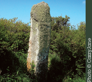
GUN RITH Alt Name: The Fiddler
Standing Stone | Nearest Village: St Buryan
Map: SW 4294 2447 Sheets: E102 L203 | Lat: 50.06466N | Long: 5.59333W
The fiddler from the Merry Maidens’ ill-fated party is to be found in a hedge in a field close to Tregiffian burial chamber. The stone has fallen several times in recent years; in 2003 it was restored in its former position but with its base set in concrete. William Copeland Borlase (the great-great-grandson of William Borlase) excavated here in 1871 and found a sandstone pebble, flattened on one side, which he conjectured had been used as a whetstone.
TREGIFFIAN Alt Name: Cruk Tregyffian
Chambered Tomb | Nearest Village: St Buryan/Trewoofe
Map: SW 4304 2443 | Sheets: E102 L203 | Lat: 50.06434N | Long: 5.59191W
Although on the mainland, this is a Scillonian type entrance grave, with a walled and roofed passage leading into a formerly circular mound (the northwest part of the mound was destroyed by the building of the road). Excavations have unearthed ashes and bone fragments. Four large capstones can be seen, and one of the portal slabs (a concrete replica – the original is in the Royal Cornwall Museum in Truro) is strikingly decorated with 25 deep cup-marks. From here, it is possible to see over to the Merry Maidens and also to Gun Rith.
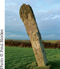
Standing Stones | Nearest Village: St Buryan/Trewoofe
Map: SW 4351 2479 | Sheets: E102 L203 | Lat: 50.064778N | Long: 5.58559W
In legend, the Pipers are two unfortunate musicians who were petrified as they fled the Merry Maidens’ Sabbath-breaking dance. The tallest of Cornwall’s remaining standing stones, the pair are in neighbouring fields more than 90m (295ft) apart. The southwest stone is 4.6m (15ft) tall; the northeast stone, which leans at quite an angle, is 4.1m (13ft 5in).
CARN GLUZE Alt Name: Ballowall Barrow
Chambered Tomb | Nearest Village: St Just
Map: SW 3552 3125 | Sheets: E102 L203 | Lat: 50.12225N | Long: 5.70148W
Hidden for many years beneath mine waste, Carn Gluze was excavated in the late 19th century by William Copeland Borlase, apparently drawn here by miners’ tales of mysterious lights and dancing fairies. This is an unusual multiphase site, perhaps originally an entrance grave that was later incorporated into a much larger and more complex structure, and further complicated by the inauthentic 19th-century restoration. Inside the barrow, within two concentric rings of walls, Borlase found five stone cists, some containing Bronze Age pottery and cremations. With imagination, the dramatic appearance of the original site can be visualized, its huge mound in a spectacular cliff-edge location.

BOSCAWEN-ÛN Alt Name: Nine Maidens
Stone Circle |Nearest Village: St Buryan | Map: SW 4122 2736
Sheets: E102 L203 | Lat: 50.08985N | Long: 5.61927W
Set in its own hedged enclosure amid the gorse and bracken, the secluded stone circle of Boscawen-ûn evokes a feeling of tranquillity in many visitors. It is famous for surrounding a central pillar that leans at a dramatic angle, giving the site something of the appearance of a sundial. Excavation in the 1860s found that this 2.5m (8ft) stone had been deliberately set up at an angle. As at some other sites in the region (such as Tregeseal, see opposite), there are 19 stones in the circle; it has been theorized that this number may reference the 18.6-year cycle of the moon’s wanderings across the sky. The stones at Boscawen-ûn are all granite except for one of quartz, which Aubrey Burl suggested may have been used as a backsight in observing the May Day sunrise. The stones of the circle vary in height but are all positioned with smoother sides facing inward, and are evenly spaced except for a larger gap in the west, which is too small for a missing stone and may indicate a solar alignment (there is a similar feature at the nearby Merry Maidens circle, see page 36).

In 1986 Ian McNeil Cooke discovered carvings of two axes in the northeast face of the central pillar. Tom Goskar, who recently used photogrammetry to create a 3D model of the carvings, believes the axes might actually represent a pair of feet, as seen on the anthropomorphic stones of Brittany and Guernsey. He also discovered a pair of circular features similar to those identified as breasts on some Breton monuments, and suggests this might indicate the reuse of a Breton-style decorated stone at Boscawen-ûn.
Nearby | At SW 4148 2763, in a field 374m (1,227ft) northwest of the circle, is the 2.6m (8½ft) Boscawen-ûn Field standing stone, with the Boscawen-ûn Hedge stone at SW 4173 2772, 265m (870ft) further east, in the hedge lining the signed track to Boscawenoon Farm.
“I should keep this a secret! The best time to visit Boscawen-ûn is on a quiet May evening when bluebells are still carpeting the circle. Something to hang on to while we endure the bleak days of winter.” Angie Lake
TREGESEAL Alt Names: Dancing Stones, Nine Maidens
Stone Circle | Nearest Village: St Just
Map: SW 3866 3237 | Sheets: E102 L203 | Lat: 50.1337N | Long: 5.65841W
A heavily restored circle in an atmospheric setting on the edge of moorland climbing to Carn Kenidjack, which here is a very distinctive feature on the skyline. There were once two or even three circles at Tregeseal lying next to each other on an east–west alignment, of which this 19-stone circle would have been the easternmost. Little trace remains of the other circles: the western or possibly central circle was cleared for agriculture in 1961, and sightings of cropmarks are the only indication of the third circle. Land management is controversial, as at some other Penwith sites (see page 41), as grazing cattle have loosened and dislodged stones and can discourage visitors. This circle is sometimes known as the Dancing Stones, referring to the common legend of maidens petrified when they broke the Sabbath.
Nearby | At SW 3901 3262, some 430m (1,410ft) ENE of the circle, are the Kenidjack Common holed stones. There are five stones here, one of them fallen and broken, with another stone to the northwest of the group. Follow the path from Tregeseal E stone circle, keeping to the lower path at each junction. The path passes a couple of tumuli, one of which is said to have a cist within it, the other the possible remains of a stone chamber.
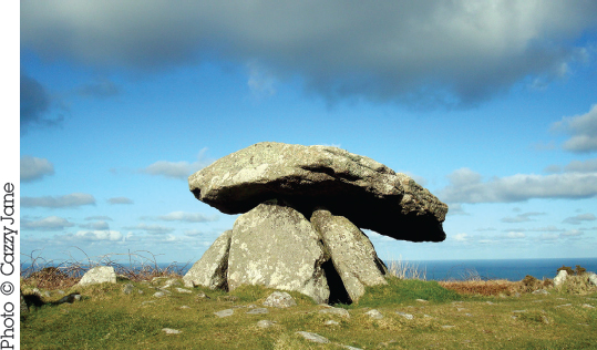
Portal Dolmen | Nearest Village: Madron
Map: SW 4022 3396 | Sheets: E102 L203 | Lat: 50.14865N | Long: 5.63771W
A perfectly preserved and charming portal dolmen with a somewhat mushroom-like appearance, its round, domed capstone (with a cup-mark on top) extending over an enclosed chamber. High on Chûn Downs, within 300m (985ft) of Chûn Castle Iron Age hill fort, the site offers spectacular views down to the sea. In 2013 the Chûn Downs area was re-registered as common land following a campaign by Save Penwith Moors (see page 41).
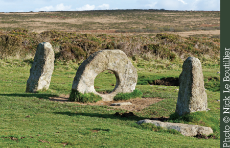
MÊN-AN-TOL Alt Name: Crick Stone
Holed Stone |Nearest Village: Madron
Map: SW 4265 3494 | Sheets: E102 L203 | Lat: 50.15851N | Long: 5.60443W
Famously picturesque. The Cornish name means “stone with the hole”, and the hole may be natural. As well as the uprights, there are six fallen stones here, some buried. The westernmost stone has been moved into line with the others at some point since 1815. William Borlase’s 1749 plan suggests the stones formed part of an arc, perhaps of a circle, although it’s unclear whether the holed stone was part of this or another structure. Being passed or crawling through the hole was once held to cure childhood rickets and tuberculosis, as well as aiding fertility, rheumatism or spinal problems in adults. There are also stories of a fairy guardian with the power to heal the sick. Recent changes in land management here have been very controversial (see opposite).
Nearby | At SW 4269 3530, 362m (1,187ft) north of Mên-an-Tol, is the 2m (6½ft) Mên Scryfa (“inscribed stone”), which may date to the Bronze Age but was carved in the 5th–8th century AD with RIALOBRANI CUNOVALI FILI – “Royal Raven Son of the Glorious Prince”. Over 1m (3ft 3in) of its length may be buried. At SW 4268 3592, 620m (less than ½ mile) north of Mên Scryfa, is the Carn Galver round barrow. At SW 4273 3600, incorporating one of the main tors of Carn Galver, are linear arrangements of large stones thought to be a Neolithic enclosure.
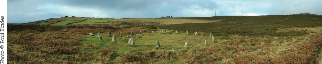
BOSKEDNAN Alt Name: Nine Maidens
Stone Circle | Nearest Village: Madron
Map: SW 4342 3513 | Sheets: E102 L203 | Lat: 50.16055N | Long: 5.5938W
The Boskednan stones stand on wild moorland, with the distinctive mound of Carn Galver a dominating feature on the horizon to the northwest and the Ding Dong mine a dramatic sight to the south. Boggy trackways lead here from Boskednan Farm and from Mên-an-Tol. The circle was restored a few years ago and there are now 11 stones, three of which are fallen, but there were once at least 19 – perhaps 22 or 23 – stones here, positioned with their smoothest sides facing inward. The stones average about 1.2m (4ft) in height apart from two taller ones in the northwest that would both have reached about 2m (6½ft) – one of which is now broken. SSE of the circle are the remains of a round cairn, a rocky mound around 10m (33ft) in diameter and 1.2m (4ft) high.

Nearby | At SW 4327 3531, 234m (768ft) northwest of Boskednan stone circle, and just off one of the footpaths coming from the direction of Mên-an-Tol and Mên Scryfa, is Boskednan northern kerbed cairn. This is one of several cairns in the area, with part of its retaining circle still visible.
Portal Dolmen | Nearest Village: Mulfra
Map: SW 4518 3536 | Sheets: E102 L203 | Lat: 50.16337N | Long: 5.56936W
This portal dolmen is not as well preserved as Chûn Quoit but its impressive hilltop setting, with views down to the coast and St Michael’s Mount, make it well worth the climb. Having lost one of its four supporting uprights, the capstone has slipped from the top of the monument and now leans against the chamber walls. Nearby are traces of a round barrow about 12m (39ft) across.
Nearby | At SW 4688 3802, up on the moors 3.2km (2 miles) northeast of Mulfra Quoit, is Zennor Quoit, which was nearly dismantled in 1861 to build a cow shed (the posts can still be seen). Its capstone has slipped and now leans on other stones. Unusually for a quoit, it has an impressive façade that forms an antechamber. Most easily approached via Higher Kerrowe and Mill Downs.
