TRETHEVY QUOIT Alt Name: Giant’s House
Portal Dolmen | Nearest Village: St Cleer
Map: SX 2593 6881 | Sheets: E109 L201 | Lat: 50.49316N | Long: 4.45549W 
Andy Burnham, founder and Editor of the Megalithic Portal
The remains of a prehistoric causewayed enclosure, now known as the Truro Eastern District Centre Neolithic Enclosure, were discovered in 2012 during building work on a future shopping and housing development. Initial findings suggest an early Neolithic date, with later activity including the deposition of late Neolithic grooved ware in pits. The finds included a stunning piece of Neolithic art, a slate disc carved with a chequerboard pattern on one side and lozenges with arrowhead decoration on the other.
This site was the first Neolithic causewayed enclosure to be found west of the Dorset– Devon border. There’s nothing to see on the ground, as the site is now beneath a Waitrose supermarket. The slate disc is kept at the Royal Cornwall Museum in Truro.
TRETHEVY QUOIT Alt Name: Giant’s House
Portal Dolmen | Nearest Village: St Cleer
Map: SX 2593 6881 | Sheets: E109 L201 | Lat: 50.49316N | Long: 4.45549W
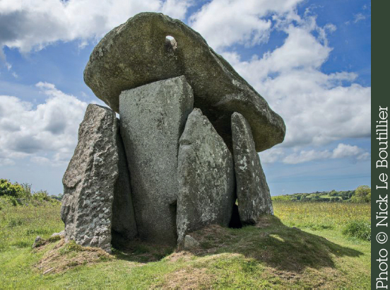
The impressive bulk and spectacular profile of this 2.8m (9ft) portal tomb make it one of Cornwall’s best-known sites. Five massive uprights (one fallen inward) on a mound are topped by a huge capstone that has slipped from position and now leans at a dramatic angle. Interestingly, there is a small hole in the eastern corner of the capstone; it’s speculated this might have been used for observing the heavens. One of the uprights protrudes, perhaps to create an antechamber at the front of the monument alongside another stone that has since been lost. “Trethevy” is Cornish for “place of the graves”. John Norden recorded it in 1584: “a little howse raysed of mightie stones, standing on a little hill within a fielde”.
Stone Circle | Nearest Village: Duloe
Map: SX 2358 5831 | Sheets: E107 L201 | Lat: 50.39812N | Long: 4.48364W
Cornwall’s smallest stone circle, a lovely oval ring of eight large stones (the tallest 2.6m/8½ft), all of white quartz. One of the stones is fallen and broken. A Bronze Age urn with a horseshoe handle containing human bones was found here in the 19th century. A geophysical survey undertaken in 2013 and 2016 by the Southeast Kernow Archaeology Survey revealed several features within the circle strongly suggesting the existence of a cist. If confirmed, while cists have been found within stone circles in other parts of the country (notably Cumbria), this would be the first example in Cornwall. A previously unrecorded outer ditch was also discovered as well as small circular anomalies that may be evidence for cremations.

“The most wonderful place, all white quartz – exquisite.” Hamish
Devon
Stone Row | Nearest Village: Harford
Map: SX 6562 5962 | Sheets: OL28 L202 | Lat: 50.421025N | Long: 3.892994W
This stone row some 2km (1¼ miles) long runs roughly north–south and links Piles Hill with Butterdon Hill, where it passes close to a large cairn. A path tracks the route of the row, mostly keeping to its western side. As is usual with the longer rows, the stones are in general relatively small – and many are well buried in undergrowth. Some of the larger stones were added as late as the 1800s.
Stone Rows | Nearest Village: Harford
Map: SX 6588 6111 | Sheets: OL28 L202 | Lat: 50.43448N | Long: 3.88987W
An avenue of stones (large ones for Dartmoor), running for almost 1km (0.6 miles) east–west over the ridge of Piles Hill. Great fun can be had tracing the line of the stones, which are now mostly fallen and buried with just their tops showing or visible as a bump in the ground.
Nearby | At SX 6605 6085, 310m (1,017ft) east of Piles Hill runs the Glasscombe Corner row, which is a double row in part. At the northeast end is a damaged cairn circle, with no stones left standing.
STALLDON Alt Names: Stalldown, The Cornwood Maidens
Stone Row | Nearest Village: Cornwood
Map: SX 6323 6248 | Sheets: OL28 L202 | Lat: 50.44617N | Long: 3.92766W
A truly impressive stone row containing 119 identified stones that follow a sinuously curving path over Stalldon Barrow hill for 859m (just over ½ mile). The stones are large for a Dartmoor row, with most over 1m (3ft 3in) and the tallest 2.3m (7ft 5in) high. The four biggest stones – the Cornwood maidens – can be seen for miles, appearing in the distance like walkers striding over the hilltop. The row was partly restored in the late 19th century; at the southern ends the slabs still lie on the ground. Apart from the circular cairn beside the row near the top of the hill, there are several other cairns to be seen, a couple still with their central cists. There are superb views from the hilltop cairn circle, and the row is all the more spectacular at sunset.
Nearby | At SX 6366 6228, some 470m (1,541ft) ESE of Stalldon Row and up on the top of Stalldown Barrow, is the large Hillson’s House cairn, which has been used over the years as a shelter.
“Wild moorland stretches off to the north, while to the south, way below, is a patchwork of fields and then the beautiful blue sea. Plymouth Sound, with its ships, can be seen to the southwest.” Martyn Copcutt
Stone Row | Nearest Village: Cornwood | Map: SX 6352 6447
Sheets: OL28 L202 | Lat: 50.46413N | Long: 3.9243W
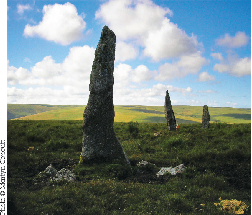
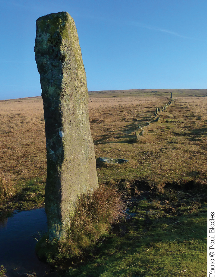
This is the longest ancient stone row in Britain, and possibly the world. At 3,386m (just over 2 miles), it stretches from Kiss-in-the-Ring stone circle up to a cairn near the top of Green Hill, crossing the river twice. Thanks to its remote location, about 1,000 stones have survived, which is likely to be around half the original number. As with most Dartmoor stone rows, the stones are rather small (about 0.5m/1½ft above the modern turf), and it can be hard to see them in summer when the vegetation is at its most exuberant. A path and darker grass by the stones show the direction of the alignment. The site is very exposed and the moor is almost featureless out here: avoid in bad weather.

KISS-IN-THE-RING Alt Names: Upper Erme Stone Circle, Stall Moor
Stone Circle | Nearest Village: Cornwood
Map: SX 6351 6444 | Sheets: OL28 L202 | Lat: 50.46386N | Long: 3.92443W
At the southern end of Upper Erme stone row, Kiss-in-the-Ring stone circle is a long desolate walk from anywhere. It’s well worth the effort, though. The tallest stone in this 16–17m (52ft 6in–56ft) circle is 1.5m (5ft 3in) high and most are less than 1m (3ft 2in) tall. There are 26 stones, but, as at all the best circles, it’s hard to count them and you may come up with a different result! The stones are unevenly spaced, with more on the western side, but none is thought to be missing. There’s a low barrow in the centre. The views south over the Erme valley are lovely, and the four large stones (the Cornwood Maidens) at the northern end of Stalldon row can clearly be seen, as can the Upper Erme row.

Megalithic Complex | Nearest Village: Shaugh Prior
Map: SX 5765 6398 | Sheets: OL28 L202 | Lat: 50.4576N | Long: 4.00744W
On the lower slopes of Trowlesworthy Tor, above the boggy land around the Blacka Brook, are a number of rows and cairns. To the north of the features described below, the remains of a large settlement can be seen, with several big enclosures walled with large slabs, and hut circles (remains on higher ground are in the best condition).
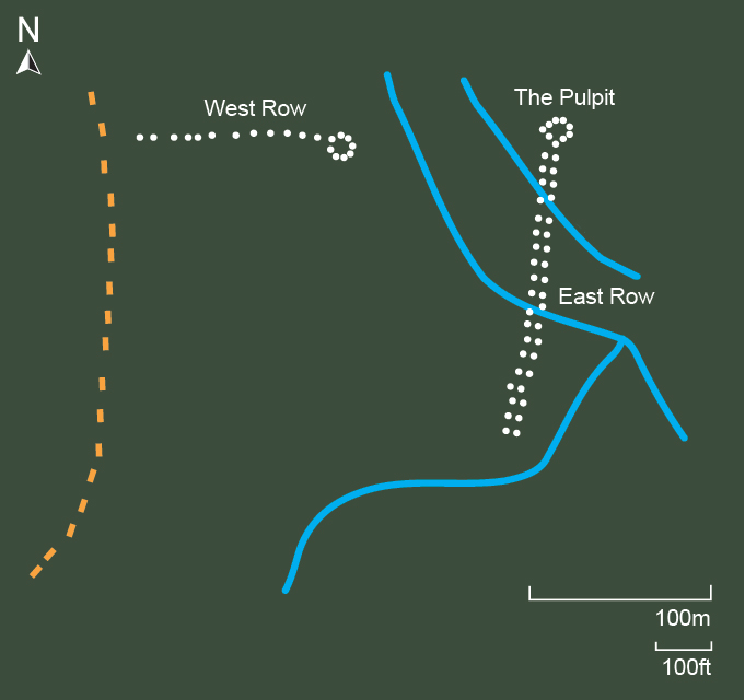
The eastern of the two rows is a splendid double avenue that winds its way diagonally across the hillside for 127m (416ft) from SX 5762 6383. Most of the original stones still remain, and are generally larger than is typical for Dartmoor avenues. A couple of leats cut through the avenue, the higher one now dry and largely filled in, but the lower still very wide, which makes following the line of the stones quite tricky.

This 6.7m (22ft) circle stands at the northern end of the double row (at SX 5765 6398), all eight stones still upright. The tallest stone is positioned where the avenue joins the circle.
The western, single row runs 82m (269ft) downhill from its cairn and circle (at SX 5755 6398). There are 44 stones remaining out of perhaps 50 originals. The row curves toward the south before terminating at a 1.3m (4ft 2in) high triangular block. Unusually, some of the stones are set across the line of the row, rather than along it. The earthwork visible a few metres from the southern end of the row has been confused with a barrow but is actually a pillow mound, created to farm rabbits and not prehistoric. At its eastern end is a 7m (23ft) round cairn, surrounded by a ring of stones.
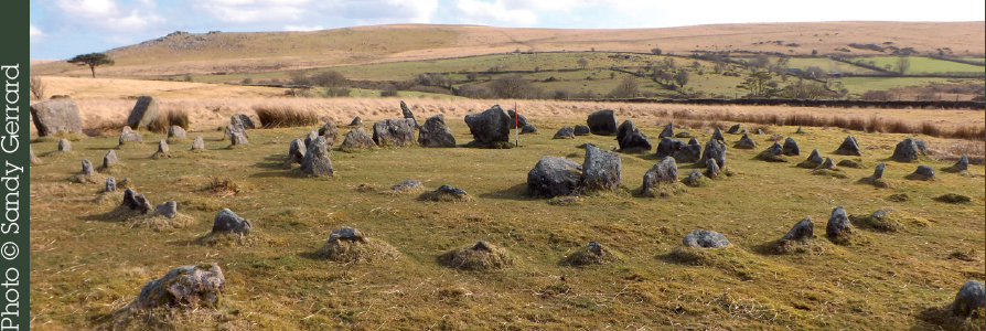
Stone Circle | Nearest Village: Shaugh Prior
Map: SX 5646 6549 | Sheets: OL28 L202 | Lat: 50.47161N | Long: 4.0241W
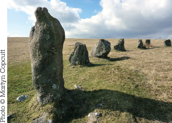
An attractive restored 24.7m (81ft) circle, with 24 stones surviving of an original 42. The stones increase in height from the south to the north, with the tallest being 1.1m (3ft 8in) high, and the flat sides of the stones face inward. A bank is visible around the northeastern quadrant of the circle and LIDAR imagery has shown this to extend around almost the entire circle. Visitors to the site have commented on various features that make this circle an unusual one, such as the broad stones, the bank and the hillside position.
Megalithic Complex | Nearest Village: Shaugh Prior
Map: SX 5640 6580 | Sheets: OL28 L202 | Lat: 50.47438N | Long: 4.02506W
On the open moor of Ringmoor Down, to the north of Brisworthy, an impressive collection of ancient sites are to be found. These include Ringmoor Down circle and row, and several cairns and settlements.
At SX 5633 6581, 345m (1,132ft) uphill northwest of Brisworthy stone circle, is the inauthentically restored Ringmoor Down cairn circle. Some of its 11 stones are not original (it’s said to have had five). Despite their diminutive height (1m/3ft 3in or less), the position of the circle in its tremendous setting at the top of the moor means it’s visible against the skyline. There is a cairn in the centre of the circle.
The stone row was apparently also subject to an ill-advised restoration in 1909 and as a result little is known as to its original length or format. It’s currently 369m (1,210ft) long, heading north from the circle, in some places a single row and sometimes a double. None of the southern stones was standing prior to the restoration, all having been affected by medieval ploughing.
The remains of several cairns are nearby, the most impressive of which is Ringmoor Down Cairn 2, a 5m (16ft) cairn found at SX 5659 6576, 264m (866ft) east of Ringmoor Down circle. It has an intact rectangular cist and the large coverstone is still partly in place.
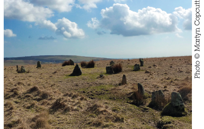
Megalithic Complex | Nearest Village: Sheepstor
Map: SX 5921 6702 | Sheets: OL28 L202 | Lat: 50.48603N | Long: 3.98595W
Wild ponies may be your only companions at this fantastically varied complex, acclaimed by some as the best on Dartmoor. The site includes three long stone rows and over 20 cairns, dramatically sited on moorland rising to Higher Hartor Tor. Each of the rows leads up to a cairn and, at the other end, down to a terminal pillar. Row 1 is a single row at either end but a double row for almost a third of its 150m (492ft) length. At SX 5899 6694, some 100m (328ft) northwest of Row 1’s terminal stone, is Stone 4. This is possibly a terminal stone for a fourth row that was never built, although it is only 1m (3ft 3in) tall, so may have been part of another structure, possibly a stone circle. On higher ground, the remains of Bronze Age enclosures and hut circles can be found. The picture right shows Row 1 with its terminal stone. In the distance the terminal stones of the other two rows are visible.
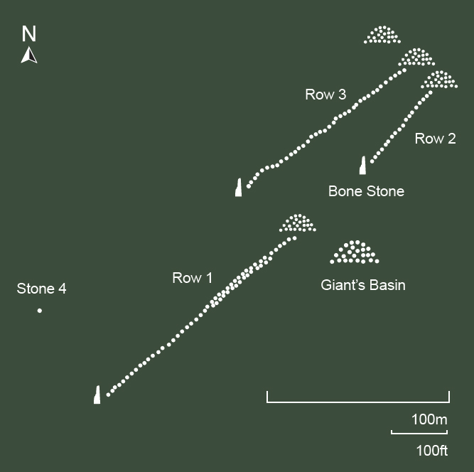
At SX 5920 6695, to the southeast of Rows 2 and 3, is the Giant’s Basin, a massive, damaged cairn measuring 22m (71ft) across and 3m (10ft) high. It has been reduced from its original height by 1m (3ft 3in) or more. Several smaller cairns can be found around the perimeter and in the surrounding area.
The characterful stone closing Row 2 is named – for obvious reasons – the Bone Stone. At 4.3m (14ft), this is the tallest standing stone on Dartmoor – and some say by far the finest in the west of England! The carvings on the northeastern face, resembling Chinese characters, were apparently put there by students in the 1950s.
Stone Circles | Nearest Village: Sheepstor
Map: SX 5748 6784 | Sheets: OL28 L202 | Lat: 50.49298N | Long: 4.01063W
Restored in 1921, these four concentric circles of stones of varying size occupy a tremendous moorland location with views up to Sheepstor, Peek Hill and Sharpitor. The innermost circle, which is formed of the largest stones, set close together, once enclosed a cairn that now is barely visible. A double stone row heads in a southwest direction from the circles, and it is possible that outliers on the western side were once part of further rows. A short distance uphill to the northeast from these circles is the remains of a small cairn, with a surrounding ring of stones. From parking near the building known as the Scout Hut, it is a very boggy 20-minute walk to the circles.
DOWN TOR Alt Name: Hingston Hill
Cairn Circle & Stone Row | Nearest Village: Sheepstor
Map: SX 5868 6927 | Sheets: OL28 L202 | Lat: 50.50612N | Long: 3.99427W
This stone row 349m (1,145ft) long undulates with the contours of the land, rising at both ends from a central low point. The drama of the uphill approach to the stone circle is enhanced by an increase in the size of the stones as the row leads up to an impressive 2.7m (9ft) terminal pillar just before the circle. Cairns lie west of this stone. The circle itself, composed of small stones (about 0.5m/1½ft in height), encloses a ruined cairn. A compass is useful for the 2km (1¼ mile) walk east from the car park at the northeast end of Burrator Reservoir.
“My new favourite site. Simply amazing!” Jeff Demetrescu

