
Martyn Copcutt, Chair of the Megalithic Portal Society and lifelong stones enthusiast
Geologically, Exmoor consists not of granite but of the softer Devonian sandstone, shale and slate. No granite megaliths are therefore to be seen, but that does not mean that ancient people did not create monuments here. Although much of the Exmoor National Park has been heavily farmed, the upland wilds still contain a wealth of relics from prehistoric times, including many ridge-top cairns and barrow cemeteries that can make for an interesting skyline.
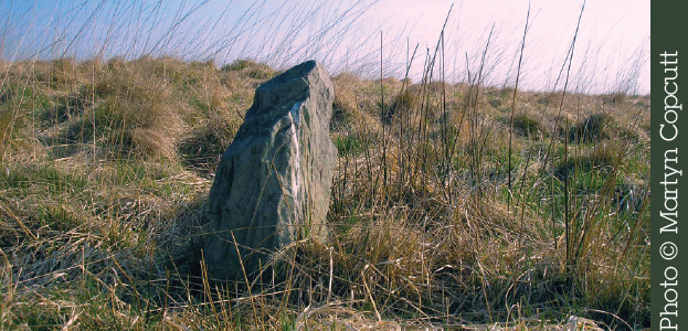
Perhaps the most intriguing of the ancient remains are the many enigmatic settings of small stones (often less than 0.3m/1ft), termed “minilithic” by Aubrey Burl. A recent survey identified 57 such monuments, which appear to be unique to Exmoor, and more are likely to be discovered as more people start looking for them. The stones are grouped in varying geometrical patterns, including quincunxes (quadrilateral arrangements with a central stone) and what appear to be random forms. Unlike other stone monuments, the minilithic settings would have required the labour of only one person over a short time to erect them. Sites can be very hard to find, as the stones are often well hidden among heather and grass. Although this type of monument was recognized by 17th-century antiquarians, the miniliths have been little studied and not much is known about them. It is only recently that detailed research into miniliths has been undertaken, with several studies made in collaboration with the Exmoor National Park authority, including by the universities of Leicester and Southampton.
Given the small size and relative fragility of the stones, the survival of these unprotected settings is remarkable. Sadly, many of the stones are now broken or missing, and the remaining minilithic sites are endangered by people riding and driving over the moor, as well as by bracken cutting. At Beckham Hill, for example, three of the original nine stones (set in three rows of three) were recorded as fallen in 1965; when I visited I found only eight stones, with just three of them still standing.
Find out more about Exmoor’s miniliths at: www.exmoorher.co.uk
Stone Alignment | Nearest Village: Simonsbath
Map: SS 7965 4272 | Sheets: OL9 L180 | Lat: 51.17101N Long: 3.72285W
In a wild Exmoor setting, on the west-facing slope of a hill above a stream, this is a six-stone rectangle, or two rows of three stones. The rows are 4m (13ft) apart and the stones rise no higher than 0.8m (2½ft), with all of them still standing.
Stone Circle | Nearest Village: Withypool
Map: SS 8383 3431 | Sheets: OL9 L181 | Lat: 51.09629N | Long: 3.66037W
A little-known circle with very small stones (most under 0.5m/1½ft) in an attractive moorland setting with great views. Around 36m (118ft) in diameter, it was first described in 1906, when 37 stones out of a possible original total of 100 were still in place. There are currently around 30, some fallen.
Nearby | At SS 8761 3431, 3.8km (under 2½ miles) east, are the Wambarrows, three damaged Bronze Age bowl barrows on top of Winsford Hill. The westernmost is the largest, 27m (88ft) in diameter, but less well defined and more overgrown than the others. Easy access for Exmoor, and superb views.
Stone Setting (Quincunx) | Nearest Village: Simonsbath
Map: SS 7940 4322 | Sheets: OL9 L180 | Lat: 51.17546N | Long: 3.72659W
There are various stone settings on Trout Hill, including this possible quincunx of which only four stones remain, one of which is fallen. The three standing are 0.5–0.8m (1ft 6in–2½ft) in height, with the stones about 7m (22ft) apart.
Ancient Trackway | Nearest Village: Westhay
Map: ST 4240 4080 | Sheets: E141 L182 | Lat: 51.16353N | Long: 2.82512W
Amazing engineering dating to 3806/3807BC, this elevated footpath ran for c. 2km (1.2 miles) across the swampy Somerset Levels. Ash, oak and lime trees were cut and transported to the site, crossed poles were driven into heavier poles underwater and pegged together, and an oak platform was laid on top. Some of the oak trees were 400 years old. The track was only in use for 10 years or so, probably due to rising water levels; this waterlogging protected it from decomposition. It was discovered by peat worker Ray Sweet in 1970. Wooden artefacts found by the track included yew pins, arrow shafts, paddles, parts of bows, and a dish. Other finds included flint arrows, pottery and two fine axes, one of flint and one of jadeite (from the Italian Alps). Some of these items could have been lost but the sheer volume of finds suggests many were deliberately left, perhaps as offerings. Sections of the track are on display in the British Museum, while much has been conserved in situ at Shapwick Heath Nature Reserve, where visitors can view replica sections along the original route. Associated with the Sweet Track is the even earlier (by about 30 years) Post Track, which followed more or less the same path and was probably dismantled when the Sweet Track was built.
Henge-type Structures | Nearest Village: Priddy
Map: ST 5400 5280 | Sheets: E141 L182 | Lat: 51.27248N | Long: 2.66079W
Considered the most important Neolithic site in Somerset but hard to see at ground level, the Priddy Circles include four 200m (655ft) earthwork enclosures arranged in a line roughly SSW–NNE. The first three are quite close together, while the northernmost circle is separated from the others by a gap of 350m (1,150ft), which appears to be deliberate. A Roman road runs through this gap. The circles have an external rather than an internal ditch, with internal banks that seem to have been revetted by wooden posts. These features have led to much speculation about whether they are henges or not; possibly they are a type of enclosure that predates henges and may have had a different function. It’s considered likely that the western third of the northernmost circle was never enclosed. In 2011, the southernmost circle was damaged.

Nearby | Priddy Nine Barrows is a group of nine Bronze Age round barrows on North Hill (at ST 5392 5149), seven more or less in a row, with a further two 137m (450ft) to the north. Some 560m (1,837m) to the north, the Ashen Hill Barrows (at ST 5390 5205) is a further group of eight barrows arranged along a ridge.
Chambered Tomb | Nearest Village: Rode
Map: ST 8149 5333 | Sheets: E143 L183 | Lat: 51.27881N | Long: 2.26676W
A long barrow with a very disturbed, almost levelled 35m (114ft) mound. Wide ditches once ran along either side of the mound but are no longer visible on the surface. At the eastern end of the mound are a number of large stones, both upright and fallen, which may have formed parts of a central passage and side chambers. Legend holds that past attempts to move or disturb the stones have always been foiled by bad weather.

“Take the footpath opposite the pub to reach a field. Follow the field boundary right, then go through a gap between fields. Keep left. Go through the next gap and follow the boundary left. The tomb is in the field corner.” Paul Beastie Baker
STONEY LITTLETON Alt Names: Bath Tumulus,
Wellow Tumulus Long Barrow | Nearest Village: Wellow
Map: ST 7350 5720 | Sheets: E142 L172 | Lat: 51.31328N | Long: 2.38159W 
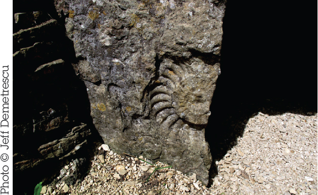
This Cotswold-Severn long barrow is surely one of the loveliest and most atmospheric in the southwest. The setting is beautiful, surrounded by wide valleys and with low hills in every direction. The impressive trapezoidal mound, running northwest–southeast, is about 30m (98ft) long, 12.5m (41ft) wide at its widest point and 2m (6½ft) high (it’s believed to have originally been much higher). It’s surrounded by a restored drystone wall, and the entrance, to the southeast, is at the back of a recessed forecourt, flanked by drystone walling. The left hand “door jamb” is decorated with a striking 0.3m (1ft) ammonite cast, and more fossils are to be found on the inner walls. Inside, there’s a 13m (43ft) gallery with three pairs of side chambers. The barrow was constructed using material from a now infilled ditch on each side. In 1816, an excavation uncovered human bones within the chamber. The walk up from the car park is straightforward, but can be muddy.
“A torch is a must as it is a crawl to the end of the barrow. Wonderfully atmospheric.” Scott Whitehouse
STANTON DREW Alt Name: The Weddings
Megalithic Complex | Nearest Village: Stanton Drew
Map: ST 6000 6330 | Sheets: E155 L172 | Lat: 51.36734N | Long: 2.57596W
A large, complex site with various monuments scattered around the tiny village of Stanton Drew. The circles were described by John Aubrey in 1664 and by William Stukeley in 1776. The remains of three stone circles and two avenues can be found, as well as the standing stones known as the Cove (a group of three) and Hautville’s Quoit.
A recent geophysical survey by English Heritage revealed that what we see today is only part of an elaborate prehistoric complex. The site’s other name, the Weddings, comes from the traditional story of guests dancing into the Sabbath and being turned to stone. As at many such sites, it’s said to be impossible to count the stones!

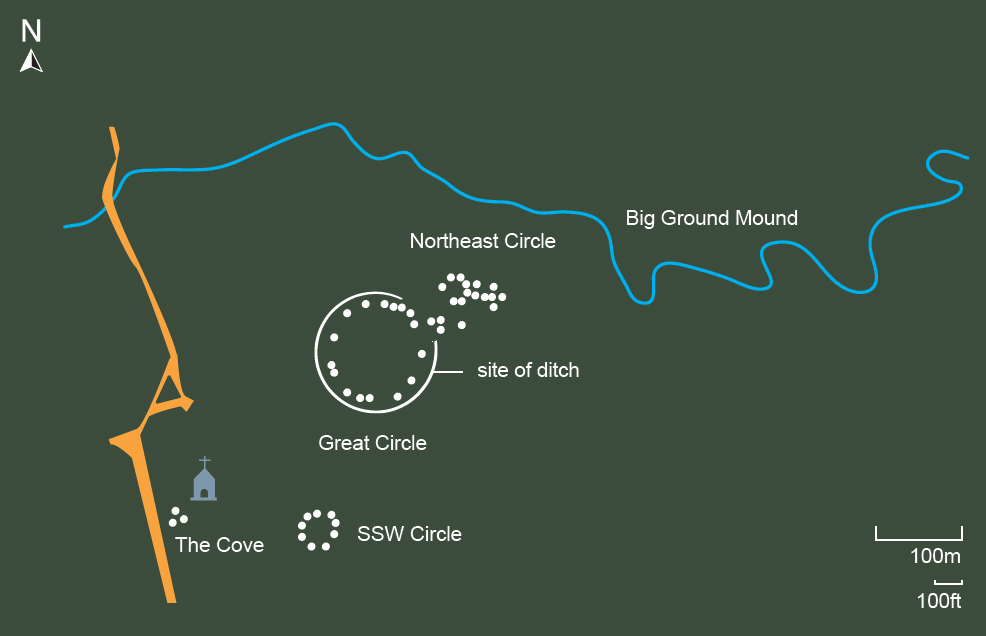
At 113m (370ft) in diameter, this is the second-largest stone circle in Britain (after Avebury). In 1998 geophysical investigation revealed the startling news that the Great Circle contains nine concentric circles of closely spaced pits that perhaps once held huge wooden posts, as at Woodhenge (see page 98) or the Sanctuary (see page 112). It was also discovered that the stone circle is sited within a 135m (443ft) enclosure, ringed by a ditch 7m (23ft) wide. Up to 26 stones remain in the circle of a possible 30 originals. The henge ditch has a large gap or entrance on the northeast, and an avenue of which five standing stones remain leading from this for some 88m (288ft) in the direction of the River Chew. There’s a legend that one of the stones will violently repel anyone who pushes it hard enough.
It’s speculated that the gap in the henge would have framed Big Ground Mound, a flat-topped hill north of the river, beyond the floodplain. Recent geophysical analysis by the Bath and Camerton Archaeological Society (BACAS) has shown this to be a natural outcrop, however it’s still possible that it may have played a part in the overal ritual landscape. Flooding was common here before Chew Valley Lake was built, and Big Ground would have been surrounded on three sides by water that stretched to the edge of the northeast circle.
Just under 100m (328ft) east of the Great Circle is an irregular 30m (98ft) circle of eight large stones. Four pits, each one aligned with an opposing pair in the outer ring, were found at the centre of the circle. It’s been speculated that these could have once held uprights or been ritual pits of some sort. A second ruined avenue heads east toward the floodplain of the River Chew and would have joined with the line of the avenue leading from the Great Circle.
Some distance to the SSW, on higher ground and in a separate field, this ruinous 43m (145ft) circle has between nine and 12 fallen stones. It occupies a plateau with views north across the other circles to the river, and west to the Cove.
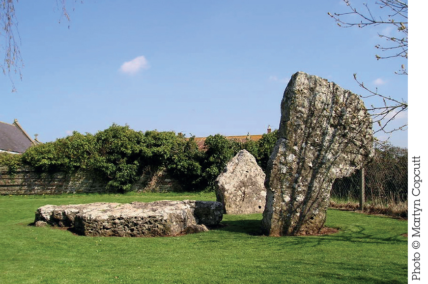
The three massive stones of the Cove, forming a rectangle with an open side to the southeast, are handily located in the garden of the Druid’s Arms pub. A line drawn through the centres of the Northeast Circle and Great Circle extends to this monument. The church and farm now interfere with any sightlines with the SSW Circle, and the Great Circle is on lower ground so may never have been visible from here. The “back” slab (4.4m/14ft 4 in) has fallen, but the other two (3.1m/10ft and 1.4m/4ft 5in) remain upright. The stones here are of different rock from the circle stones, suggesting a different origin and possibly an earlier date. In folklore, the two upright Cove stones are the bride and groom, with the fallen stone the drunken parson.
Nearby| At ST 6017 6381, less than 500m (1,640ft) NNE across the River Chew from the Northeast Circle, is Hautville’s Quoit, a large fallen stone that’s assumed to once have stood, possibly as part of a chambered tomb. This stone lies on a line running through the centres of the Great Circle and the SSW Circle. Stukeley recorded it as being 4m (13ft) but it has since been broken and is now about 2.2m (7ft). The stone is said to be named for Sir John Hautville, a 13th-century knight who was supposed to have hurled it into its current position.
Gloucestershire
HETTY PEGLER’S TUMP Alt Names: Uley Long Barrow, Uley
Tumulus Chambered Tomb | Nearest Village: Uley
Map: SO 7896 0003 | Sheets: E168 L162 | Lat: 51.69861N | Long: 2.30583W
This Cotswold-Severn-type transepted gallery grave has two chambers on each side of its passage plus an end chamber. The entrance is in a forecourt on the east and the mound rises to 3m (10ft). Human and animal bones, as well as Neolithic pottery, were found here during excavations in the mid-19th century. It’s named after Hester Pegler, who appears to have owned the land on which it stands in the 17th century.
“When I was a child you had to get the key from a house in the village. My dad unlocked the little door and in we crawled. The smoke from the last visitor’s candle was still hanging in the air. Unforgettable.” Jackie Bates
Nearby | At SO 7940 0132, 1.4km (under 1 mile) NNE of Hetty Pegler’s Tump, Nympsfield long barrow is another chambered long barrow or transepted gallery grave of the Cotswold-Severn type, with a pair of side chambers and an end chamber. Excavations in 1862, 1937 and 1974 uncovered skeletons (perhaps from as many as 20–30 individuals).
THE LONG STONE (MINCHINHAMPTON)
Standing Stone | Nearest Village: Minchinhampton
Map: ST 8835 9992 | Sheets: E168 L162 | Lat: 51.69788N | Long: 2.16997W
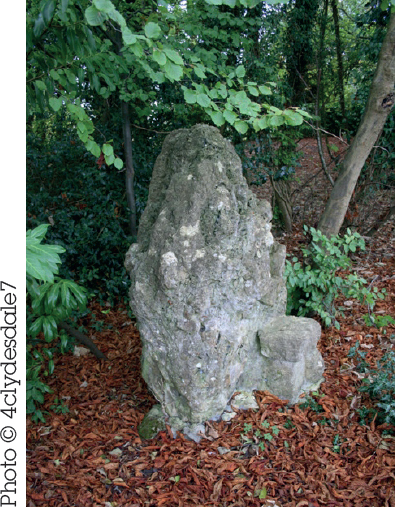
A lovely 2.3m (7ft 5in) stone with several holes that offer lots of opportunities for fun photos as people put their hands through, as well as added healing properties if the folklore is to be believed. It’s been speculated that this, as well as another stone in the nearby field wall, are the remains of a burial chamber.
Nearby | At ST 8823 9899, just under 1km (0.6 miles) SSW of the Long Stone, in the Gatcombe Park estate that is home to Princess Anne, is the Tingle Stone, probably the remains of another chambered long barrow. It’s on private land so stick to the footpath (which doesn’t reach the stone) or wait for the horse trials.

The Rev N. Thornbury removed the three Avening burial chambers c.1806 from either Avening Court or Norn’s Tump long barrows and set them up in the garden of his rectory at Avening (at ST 8789 9837). The “porthole”-style entrance is unusual for Britain. Permission from the landowner is needed to visit them, but two can be seen (just about) to the east of the main road north of Avening.
“Folklore has it the stone wanders around the field when church bells strike 12 – AND that it is haunted by a former owner of Gatcombe Park on a horse!” 4clydesdale7
Standing Stone | Nearest Village: Rodborough
Map: SO 8577 0241 | Sheets: E168 L162 | Lat: 51.72023N | Long: 2.20739W
Rediscovered in a back garden in 2001, thus settling years of controversy over whether this stone, last recorded in 1636, still existed. There is a medieval boundary stone about 250m (820ft) away, which has been mistaken for the stone in the past, but the true Horestone is 1.8m (6ft) tall and made of the same holey freestone as so many other local standing stones. Further details of this stone and its neighbour can be found by searching the Megalithic Portal for the Horestone (Rodborough) and the Horestone (Sullivan) respectively.
Standing Stone | Nearest Village: Staunton
Map: SO 5593 1206 | Sheets: OL14 L162 | Lat: 51.80543N | Long: 2.64056W
Standing beside the A4136, this characterful 2.5m (8ft) stone is of deeply scored and weathered sandstone. Local tradition states that it will bleed if pricked with a pin at midnight.

Nearby | Ochre mining at Clearwell Caves (at SO 5770 0822), on the western edge of the Forest of Dean, may date back 7,000 years, with stone tools from 4,500 years ago discovered here. Clearwell ochre contains high levels of iron, giving it an unusually strong colour pigment, and it is still mined here today.
Long Barrow | Nearest Village: Winchcombe
Map: SP 0209 2545 | Sheets: OL45 L163 | Lat: 51.92756N | Long: 1.97101W
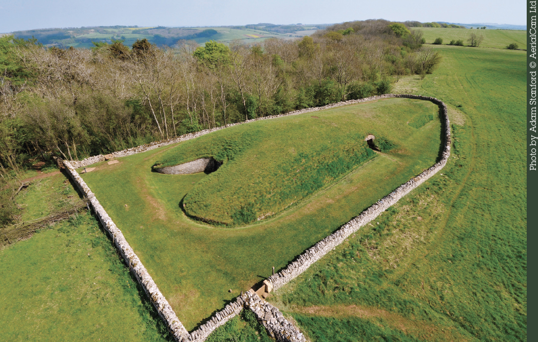
A fine long barrow (pictured opposite), its current impressive appearance shaped by restoration in 1928–30. The 55m (180ft) mound runs north–south and was once larger, now rising to 4m (13ft) high and stretching to 20m (66ft). Unlike other local barrows, there’s no entrance or central passage; instead, at the northern end, there’s a “false entrance”, with two standing stones and a lintel, between the curved horns of the forecourt. The four chambers, two on the east, one at the southern end and one on the west, each have individual entrances. Excavation uncovered the remains of 37 people in the four chambers and under the false entrance. Romano-British pottery was also found, showing that it was accessible in that era.
“Belas Knap is part of an ancient landscape that includes Cleeve Common, and the barrow is intervisible with the upper slopes of the common to the west. It’s worth taking a whole day to explore the area, as there are Bronze Age dykes and an Iron Age camp – oh and the stunning views …” Dr Olaf
WINTERBOURNE NINE STONES Alt Names: Devil’s Nine Stones, Nine Ladies, Lady Williams and Her Dog
| Stone Circle | Nearest Village: Winterbourne Abbas
Map: SY 6108 9043 | Sheets: OL15 L194 | Lat: 50.71219N | Long: 2.5526W
First recorded by John Aubrey in the 17th century and hardly changed since, this little circle (8m/26ft) is unusually located in a valley bottom. It is unexpectedly atmospheric, despite the proximity of the A35. The stones, of varying size, are evenly spaced, with a larger gap to the north. Aubrey described another circle (no longer there) about 800m (½ mile) west of here. The fallen 2m (6½ft) Broad Stone lies semi-buried beside the road about a mile to the west. Access from the A35 has been blocked, but at the time of writing, parking is possible across the field to the east, at the site of the old Little Chef (pending redevelopment). A gate here gives on to a path to the stones.

Nearby | On Long Barrow Hill (at SY 5717 9115), Long Bredy bank barrow is, at 195m (640ft), the second longest in Britain (after the one at Maiden Castle, see page 85). Ditches run in parallel along either long side. The barrow can be seen in both directions from the A35; look for the V-shaped notch. There are various other sites close by, including what may be cursus to the northeast, and other barrows.
Dorset
Stone Circle | Nearest Village: Abbotsbury
Map: SY 5779 8783 | Sheets: OL15 L194 | Lat: 50.68858N | Long: 2.59889W
On a chalk ridge above the Bride valley, with views south and west to the sea, this irregular 30m (98ft) circle of fallen sarsen and conglomerate stones is not far from the Grey Mare and Her Colts. There are 18 stones, one of which was still standing in 1815. Two similar stones lie close to a nearby fence. Some of the stones are partially buried and so may be larger than they appear.

Nearby | At SY 5839 8706, just short of 1km (0.6 miles) southeast of Kingston Russell circle, Grey Mare and Her Colts is a well-preserved long barrow with a 24m (78ft) mound. At the southeast end are four impressive sarsens, three of which are still standing. A fifth, possibly the capstone, lies at the southwest end of the row. The remains of a collapsed chamber lie behind the sarsens.
“Parking is only possible on verges of minor roads a mile or two away. Resist the temptation to drive down the farm-access tracks as you may get into trouble!” Jim Champion
Long Barrow | Nearest Village: Portesham
Map: SY 6058 8670 | Sheets: OL15 L194 | Lat: 50.67861N | Long: 2.55928W
A much-damaged and inaccurately restored but very dramatic-looking long barrow. The mound is at least 24m (78ft) long, up to 12m (40ft) wide and 1.5m (5ft) high near the chamber, but further southeast it is much disturbed and barely 0.6m (2ft) high. The chamber was rebuilt in 1866 and nine stones, up to 1.7m (5ft 7in) tall, now support the huge 3 × 2.4m (10 × 8ft) capstone.
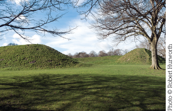
Barrow Cemetery | Nearest Village: Portesham
Map: SY 6267 8688 | Sheets: OL15 L194 | Lat: 50.68037N | Long: 2.52972W
A group of round barrows stretching northwest-southeast for about a mile along the Ridgeway. The group includes four bell barrows and a double bowl barrow.

Nearby | There are various other barrow cemeteries to be explored in the area. The Hardy Monument barrows (at SY 6130 8760), 1.5km (just under 1 mile) WNW of Bronkham Hill, have spectacular views.
Causewayed Enclosure & Bank Barrow | Nearest Village: Winterborne Monkton
Map: SY 6690 8846 | Sheets: OL15 L194 | Lat: 50.69483N | Long: 2.46999W
The dramatic Iron Age hill fort is the most impressive element of the site, but this hilltop has been the focus of occupation for more than 6,000 years. A Neolithic causewayed enclosure, one of the largest in England (approximately 8ha/20 acres), is buried under the embankments of the early phase hill fort, which probably followed its outline. When the enclosure went out of use, a 550m (1,805ft) bank barrow was built across its western side, flanked by ditches. The barrow is still visible, just about. In the early Iron Age, a single rampart was built on top of the earlier enclosure, and later the fort was extended to enclose more than double the original area. The entrances became more complex, extra ramparts were added and the inner rampart was heightened. Maiden Castle was featured in the first-ever English-language archaeology TV show, broadcast by the BBC in 1937. A downloadable audio tour is available from English Heritage.
Henge | Nearest Town: Dorchester
Map: SY 6901 8992 | Sheets: OL15 L194 | Lat: 50.70808N | Long: 2.44024W
Surrounded by new development, this late Neolithic henge, more than 100m (328ft) in diameter, was used as an amphitheatre by the Romans and as an artillery fort during the Civil War. Excavations in the early 20th century revealed a wide ditch inside the circular bank, with a series of shafts (possibly around 45) up to 11m (36ft) deep. Eight were found to contain red-deer skulls and human and animal bone fragments, as well as carved chalk objects (including the famous phallus). The shafts may have been deliberately backfilled. The entrance is to the northeast. A stone that once stood to the west of the entrance is said to have been discovered and reburied in the 19th century, its location now unknown.
Nearby | In the car park under the Dorchester Waitrose, the position of some post-holes from a huge timber circle are marked on the ground. Discovered during development, the circle is estimated to have been some 380m (1,245ft) in diameter, requiring the trunks of 600 mature oaks. It was radiocarbon-dated to around 2100BC. Also in Dorchester is the Flagstones enclosure, partly sited under the grounds of Max Gate, Thomas Hardy’s old house. It is a 100m (328ft) interrupted ditch enclosure (similar to a causewayed enclosure), formed by a ring of pits. Human remains were found, including an infant and a baby in the pits, and a young man in a central barrow. Carbon-dating puts this burial about 1,000 years later than the enclosure, which dates to around 2486–2886BC.
Henge-type Structures | Nearest Village: Gussage All Saints
Map: SU 0238 1028 | Sheets: E118 L195 | Lat: 50.89199N | Long: 1.96753W
There are four henges or henge-type earthworks at Knowlton. The best-known and best-preserved is the Church Circle, which contains the ruins of a Norman church. To the east, is the Great Barrow, the largest round barrow in Dorset. Other barrows and ring ditches are scattered in the surrounding area. The Northern, Southern and Church Circles are generally accepted as henges, while the status of the fourth earthwork, known as the Old Churchyard, probably predates the medieval period. A large stone, ploughed out of the Southern Circle in the 1970s, features four concentric pecked rings. If this is indeed prehistoric rock art, it is highly unusual for the region.
Nearby | Some 5km (3 miles) southwest of Knowlton Rings, on private land with no access, High Lea Farm was until 2008 the focus of Bournemouth University’s Knowlton Prehistoric Landscape Project. There’s an early Bronze Age cemetery of round and oval barrows, most of which are now visible only as cropmarks.
Barrow Cemetery | Nearest Village: Sixpenny Handley
Map: SU 0182 1731 | Sheets: E118 L184 | Lat: 50.95521N | Long: 1.97546W
A fine cemetery containing over 30 round barrows of various types, some of which are clearly visible from the A354 south of Woodyates. The Roman road, Ackling Dyke, passes through the cemetery, over two of the disc barrows.

Nearby | The excavation into Wor barrow (at SU 0124 1729), 579m (1,900ft) west of Oakley Down barrows, by General Pitt Rivers in 1893–4, is considered to be the earliest investigation of a long barrow to modern scientific standards. In one of the first examples of experimental archaeology, Pitt Rivers then studied the re-silting of the ditches over the following years, and decided this wasn’t a reliable method for dating earthworks. Six male skeletons were found inside the original mortuary chamber, but the site is best known for a secondary burial that was placed in the ditch after construction. The body had been preserved for 30–130 years before burial, making it the earliest known “mummy” in Britain. A flint arrowhead between the ribs gave insight into the probable cause of death.
Cursus | Nearest Village: Sixpenny Handley
Map: SU 0175 1600 | Sheets: E118 L184 | Lat: 50.94343N | Long: 1.97717W
Probably Britain’s largest Neolithic site, the Cursus runs for 10km (6 miles) northeast–southwest across the chalk downland of Cranborne Chase. Originally a pair of parallel banks about 90m (295ft) apart, it is now mainly visible as cropmarks, although some earthworks are still present, including two associated long barrows and the remains of banks in Salisbury Plantation on Oakley Down, and on the northeast-facing slope of Bottlebrush Down. It’s been estimated that the Cursus took around half a million hours to construct, and may have been built in two phases, with the 5.6km (3½ mile) southwest section completed first. It’s well worth visiting, despite lack of visible remains. There is no public right of way along the whole of the Cursus but the area is criss-crossed with paths and lanes.
Nearby | At Wyke Down (SU 0060 1530) are two henges (one only discovered in 1995), just 40m (131ft) apart. The ditches were constructed as a serious of pits. Excavation in the 1980s revealed pottery sherds, flint tools and carved chalk objects at the first site, with further pottery, including an almost complete grooved ware pot, found at the second in 1996.
