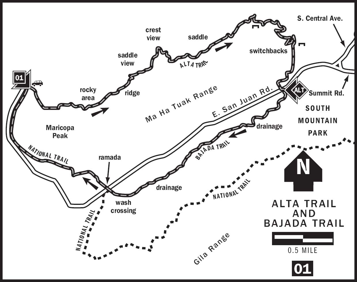
01 ALTA TRAIL AND BAJADA TRAIL
KEY AT-A-GLANCE INFORMATION
LENGTH: 8.5 Miles
ELEVATION GAIN: 1,200 feet
CONFIGURATION: Loop
DIFFICULTY: Alta Trail: difficult; Bajada Trail: easy
SCENERY: City panorama, South Mountain Park, Sierra Estrella, desert
EXPOSURE: Limited shade, mostly exposed
TRAFFIC: Light
TRAIL SURFACE: Crushed rock, gravel, packed dirt
HIKING TIME: 4 hours
WATER REQUIREMENT: 2.5 quarts
SEASON: Year-round; hot in summer
ACCESS: Trails open sunrise–sunset, park open 5 a.m.–10 p.m.; free parking
MAPS: USGS Lone Butte and Laveen, park map on trailhead plaques and available from visitor center
FACILITIES: None at trailhead. Visitor center, restrooms, picnic areas, riding stables, and go-cart racecourse available inside park
DOGS: Yes, leashed at all times
COMMENTS: Not as crowded as the trails on the eastern end of South Mountain. For more information, visit phoenix.gov/recreation/rec/parks/preserves/locations/south/hiking/index.html.
GPS Trailhead Coordinates
UTM Zone 12S
Easting 0393577
Northing 3688294
Latitude N33°19.819'
Longitude W111°8.650'
Directions
Travel south on Central Avenue until it terminates at South Mountain Park. Once inside the park, follow the main road to the junction of Summit Road and San Juan Road. Follow San Juan Road 4 miles until it ends at the San Juan Lookout.
This loop hike can also be accessed via the Alta–Bajada junction on San Juan Road. Limited parking is available here.
San Juan Road is currently accessible by car only one weekend per month due to recent fire damage. Check the City of Phoenix Parks Web site for latest road information.
IN BRIEF
Fewer fellow hikers and a complete lack of mountain bikers make the Alta Trail inviting to those who prefer to hike undisturbed in South Mountain Park. Alta Trail is the most challenging trail in the park. The Bajada Trail and the tail end of the National Trail complete an enjoyable loop.
DESCRIPTION
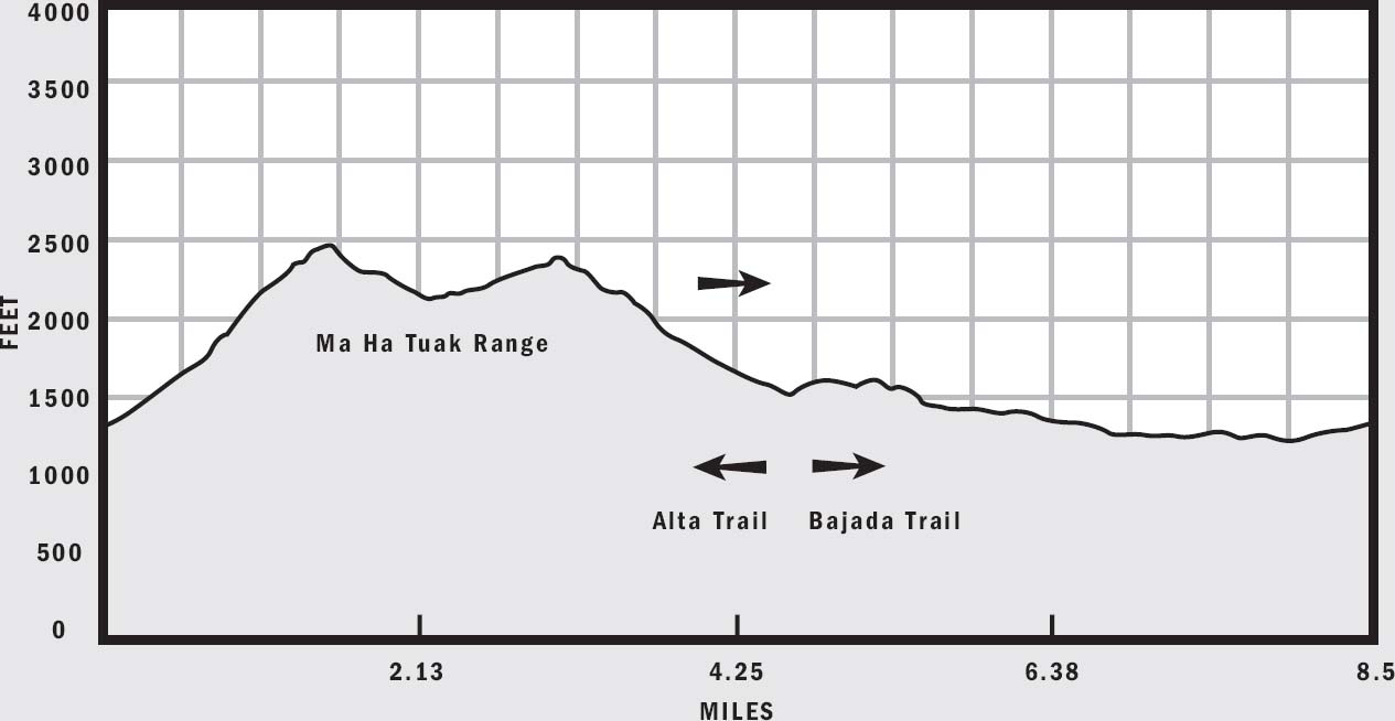
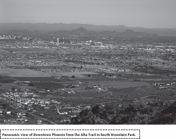
There are three mountain ranges within the 16,000-acre confines of South Mountain Park, the largest municipal park in the country. The Ma Ha Tuak Range, the most unpronounceable of the three, is also the least visited mountain range. Located away from the busiest sections of South Mountain Park, the Ma Ha Tuak Range offers hikers a challenging trek sans the crowds and mountain bikers. Alta is the only trail in the Ma Ha Tuak Range. As its name suggests, the Alta Trail along Ma Ha Tuak’s spine gains 1,200 feet in elevation, the most in South Mountain Park. However, some of the best views of the Phoenix skyline await those who accept this challenge.
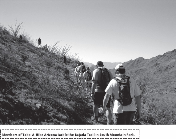
South Mountain Park boasts a superb network of trails that begs creative hikers to define their own loops. A popular loop includes the Alta Trail, the Bajada Trail, and the tail end of the National Trail. The Alta Trail runs from the San Juan Lookout at the extreme northwestern corner of the park to a point along San Juan Road, which traverses the valley between the Ma Ha Tuak and Gila mountain ranges. Hikers can either arrange a car shuttle for a one-way hike on Alta Trail or take the gentler Bajada Trail and then the National Trail to complete a pleasant 8.5-mile loop. The Bajada Trail, whose name means slope in Spanish, parallels San Juan Road and runs along the base of the Gila Range. Looping back on the Bajada Trail offers a mild warmdown after hiking the rigorous Alta Trail.
Begin this loop at the San Juan Lookout and climb southeast toward Maricopa Peak. The well-defined Alta Trail immediately ascends a hefty slope among desert grasses and palo verde trees, with views of southwestern Phoenix in the distance. At 0.4 miles, the trail bends north and provides a little respite from your laborious task. Soon, the pace picks up again as the trail rounds a corner and resumes its uphill trend. You are now walking up the flank of a narrow upper basin on the northern side of the mountain. Similar to most mountains in the Sonoran Desert, the northern slopes host more trees and shrubs such as the brittlebush, creosotes, and smaller cacti, while the drier southern slopes cater to the needs of giant saguaros and teddy bear chollas.
Steeper switchbacks greet you near 0.6 miles. Choose your steps carefully because the trail becomes a bit rocky and loose. Large boulders here provide some cool shade in early mornings and late afternoons. Continue ascending a fairly steep grade along the northern flank of the Ma Ha Tuak Range to an ocotillo-studded ridge crest at 1.1 miles. If you need a break here, turn to admire the Sierra Estrella mountain range behind you to the west, most of southwestern Phoenix, and the White Tank Mountains to the northwest. A bit farther along the trail, top out on the summit ridge where you have an open view to the south as well. The Gila River Indian Reservation and the interior valley of South Mountain Park are visible from this vantage point.
Forge ahead along the trail as it continues to ascend switchbacks toward the tallest point of the hike. At 1.5 miles, reach a prominent saddle at 2,460 feet of elevation where an awesome view of Phoenix presents itself. This saddle is a great spot to take a breather. In addition to the tall buildings of downtown Phoenix along Central Avenue and the crowded metropolis, you can spot pointy Piestewa Peak, the sleeping camel of Camelback Mountain, and numerous mountains to the northeast.
Even though you have just conquered the highest point on the hike, much work remains because the trail bobs up and down along the ridgeline. Past the high saddle point, the Alta Trail descends a series of switchbacks and drops 220 feet in elevation to a patch of rough terrain. Then, the cruel ascent resumes as the trail traverses the side of a steep hill toward the east, with the antenna array on top of Mount Suppoa barely visible directly ahead. When you reach the top of the ridge again at 2.5 miles, a narrow saddle offers an unobstructed view into the interior of South Mountain Park. Continue northeast near the top of the ridge, crossing over to the southern side of the hill at 2.8 miles.
Your climb finally ends at a 2,390-foot saddle, regaining most of the lost elevation from the highest point on the hike. From here, you enjoy a great view of Four Peaks off in the distance and the relaxing feeling that all the elevation gain is now behind you. The Alta Trail begins to descend gently at first but then steeply via a series of switchbacks through fields of teddy bear cholla, fishhook barrel cactus, and some elephant trees. As you descend, look for several rock benches built under chollas, and look across the valley for an abandoned mine on the northern side of the Gila Range.
Once the trail drops down to the valley floor between the Ma Ha Tuak and Gila ranges, it flattens out and becomes much easier to negotiate. Hike south-westward with the Sierra Estrella mountains directly ahead of you until the Alta Trail terminates on San Juan Road at a small parking lot where the Bajada Trail begins. You have just covered the most challenging 4.6 miles in South Mountain Park.
To loop back to the San Juan Lookout, head out on the Bajada Trail from the parking lot and climb up to the skirt of the Gila Range. Even though the slope of this climb pales in comparison to the Alta Trail, the short ascent will still make your muscles strain and take notice. Fortunately, the Bajada Trail soon levels out and traces a path parallel to the road and along the base of the mountain.
The Bajada Trail stays mostly level and takes you through classic Sonoran Desert scenery. The gentle stroll along the Bajada Trail contrasts sharply with the huffing-and-puffing difficulty of the Alta Trail. At 5.3 and 6.5 miles, cross a couple of drainages on the side of the hill, and then cross the main dry wash on the valley floor. Just before reaching San Juan Road again, the Bajada Trail terminates at a junction with the National Trail.
The last section of this loop hike follows the westernmost part of the National Trail. Much like the Bajada Trail, the final 1.5 miles of the National Trail remains relatively flat. Cross San Juan Road and continue along the National Trail as it skirts the western end of the Ma Ha Tuak Range. The trail asymptotically approaches San Juan Road and ends at the San Juan Lookout where the loop began.
NEARBY ACTIVITIES
South Mountain hosts many hiking and biking trails including National, Desert Classic, Mormon, Ranger, and Telegraph Pass. Many other recreational activities such as picnicking and horseback riding are also available. The Environmental Education Center, located near the Central Avenue entrance, has a superb visitor center, complete with a three-dimensional model of the entire park.