04 HIDDEN VALLEY TRAIL VIA MORMON TRAIL
KEY AT-A-GLANCE INFORMATION
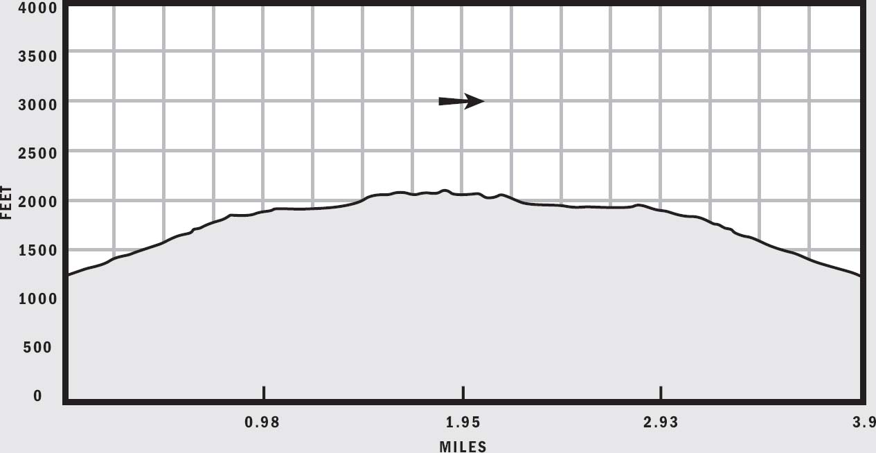
LENGTH: 3.9 miles
ELEVATION GAIN: 775 feet
CONFIGURATION: Balloon
DIFFICULTY: Moderate, a little easy scrambling
SCENERY: Desert, city views, Hidden Valley, Fat Man’s Pass, unique rock formations
EXPOSURE: Completely open, very little shade
TRAFFIC: Moderate
TRAIL SURFACE: Gravel, crushed rock, packed dirt, smooth bedrock
HIKING TIME: 2 hours
WATER REQUIREMENT: 2 quarts
SEASON: Year-round; hot in summer
ACCESS: Open 5:30 a.m.–7:30 p.m.; free parking
MAPS: USGS Lone Butte, park map posted on plaques at trailheads
FACILITIES: Drinking water and shaded ramada, no toilet
DOGS: Yes, leashed at all times
COMMENTS: This is the shortest route to visit Hidden Valley in South Mountain Park. For more information, visit phoenix.gov/PRL/hidden.html.
GPS Trailhead Coordinates
UTM Zone 12S
Easting 0404148
Northing 3692184
Latitude N33°21.983'
Longitude W112°1.862'
Directions
Exit Interstate 10 at Baseline Road and drive west 3.7 miles to 24th Street. Turn south onto 24th Street and follow it until it ends at Valley View Drive. Turn left to find the trailhead parking lot on Valley View Drive.

IN BRIEF
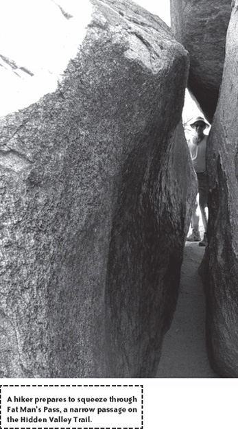
Hidden Valley Trail is the hidden gem of South Mountain that traverses an enclave of wilderness where all signs of the city disappear. Perched atop the Guadalupe Range, this quiet half-mile trail boasts some of the most scenic rock formations in the region, including a natural rock tunnel and Fat Man’s Pass.
DESCRIPTION
South Mountain contains over 16,000 acres of desert and mountain preserves, spanning almost the entire southern boundary of Phoenix. It is the largest municipal park in the country. Since 1924, visitors have enjoyed these mountains for their rustic beauty. The Civilian Conservation Corps built numerous trails, roads, picnic facilities, and lookouts in the park. Today, more than 3 million visitors come here annually to enjoy splendid hiking, mountain biking, sightseeing, and various other recreational activities. Though the population of Phoenix and visitor traffic to South Mountain have skyrocketed in recent decades, one part of South Mountain remains relatively untouched by the constant influx of people: Hidden Valley.
The half mile long Hidden Valley Trail takes hikers through this stretch of charming wilderness, which lies atop the Guadalupe Range and holds the most scenic rock formations in the entire park. Two such formations, a natural rock tunnel and Fat Man’s Pass, act as sentinels posted at the ends of the trail to guard the entrances into Hidden Valley. Once you’re inside, all signs of the city vanish, along with most of the traffic and noise on the busy National Trail. The tranquil valley further entices you with sandy wash beds and beautiful granite boulders and rocks unlike those found elsewhere on South Mountain.
The Hidden Valley Trail is really just a detour along the National Trail, forming a small loop beginning at 2.6 miles on National’s 15-mile course. The easiest way to reach Hidden Valley is to hike up the Mormon Trail, which intersects this loop on the National Trail side. The resulting Mormon–National–Hidden Valley balloon is one of the most enjoyable short hikes on South Mountain. This circuit presents a desirable alternative to the often overcrowded National–Mormon Loop that is accessible from the eastern end of South Mountain.
Park in a small lot on 24th Street and Valley View Drive. Begin by ascending the hill at the western end of the parking area up to the ridge where a trailhead plaque displays park information and a map. The Mormon Trail heads southeast atop the ridge and begins a moderate climb up South Mountain. Along the trail, you’ll find familiar desert plants such as creosote bushes, palo verde trees, and saguaro cacti. At 0.3 miles, top out on a small saddle where you can turn and survey the parking lot below and the housing developments encroaching on the base of the mountain. From here, you can also see downtown Phoenix, Piestewa Peak, Camelback Mountain, McDowell Mountains, and the red sandstone buttes in Papago Park.
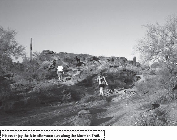
Continue following the Mormon Trail as it snakes uphill. The trail gets progressively more difficult, and at 0.6 miles switchbacks carry you up a fairly steep section. Power through this section because it is the only moderately difficult ascent on this hike. The slope soon gives way to a high flat basin at 0.9 miles and an elevation of 1,900 feet. The Mormon Loop Trail joins in from the left at 1.1 mile. This trail parallels the National Trail and takes you to Pima Canyon Park at the eastern end of South Mountain. Continue straight on the Mormon Trail until it ends and Ts into the National Trail at a signed junction 1.4 miles into the hike.
At this point you can go either way. I prefer to go up first and do the loop in a counterclockwise direction because route finding in Hidden Valley is a bit easier when going from west to east. Turn right onto the National Trail and watch for speedy mountain bikers. National Trail meanders and climbs gently for 0.4 miles until it crests at 2,100 feet before dropping down slightly. At this point, look for trail marker number 13 at the Hidden Valley Trail junction. Turn left and leave the National Trail here. A few feet later, Fat Man’s Pass comes into view.
This misnamed wonder is one of the most popular features on South Mountain. A thin crack measuring nearly 25 feet long and only nine inches wide at one point, Fat Man’s Pass tempts kids and adults alike. Walls of the crack have been worn smooth by thousands of sweaty torsos squeezing through it over the years. Take off your pack and shuffle through sideways. Don’t forget to suck in that gut! If you are claustrophobic or are carrying a few extra holiday pounds, simply go over the boulders instead of through the crack. Kids will also enjoy sliding down a naturally smooth rock just to the right of the entrance to Fat Man’s Pass.
On the other side of Fat Man’s Pass, walk along a sandy dry wash dotted with riparian brush. At 2 miles from the trailhead, a cluster of large boulders blocks the path. You can either squeeze under or climb over them and then jump down a few feet into a large open bowl. Turn to admire the scenic rocks through which you came before continuing along the sandy wash bottom. At 2.2 miles, a natural granite wall challenges you to climb or jump down five feet or so. Be careful with your footing on the smooth and slippery rock.
The trail turns north soon after the rock wall and arrives at the other striking feature along the Hidden Valley Trail, a natural rock tunnel formed by overlapping boulders. Look through the 30-foot-long tunnel and you can see its worn walls shimmer in the light from the other side. Watch your head as you walk through this wide tunnel. On the other side of the tunnel, look for some petroglyphs etched into the rock by the Hohokams who inhabited this area hundreds of years ago.
Hidden Valley Trail rejoins the National Trail at 2.4 miles from the Mormon Trailhead. Turn left onto National Trail here, and hike 0.2 miles to the Mormon Trail junction. Turn right and descend via the Mormon Trail with the skyline of Phoenix in front of you.
NEARBY ACTIVITIES
South Mountain Park boasts many hiking and biking trails, including Alta, Desert Classic, National, Ranger, and Telegraph Pass. Many other recreational activities such as picnicking and go-cart racing are also available. The Environmental Education Center, located near the Central Avenue entrance, has a superb visitor center, complete with historical exhibits and a three-dimensional model of the entire park. Dobbins Lookout and Buena Vista, both of which are accessible by car, offer superb views of Phoenix by day and the city lights by night.