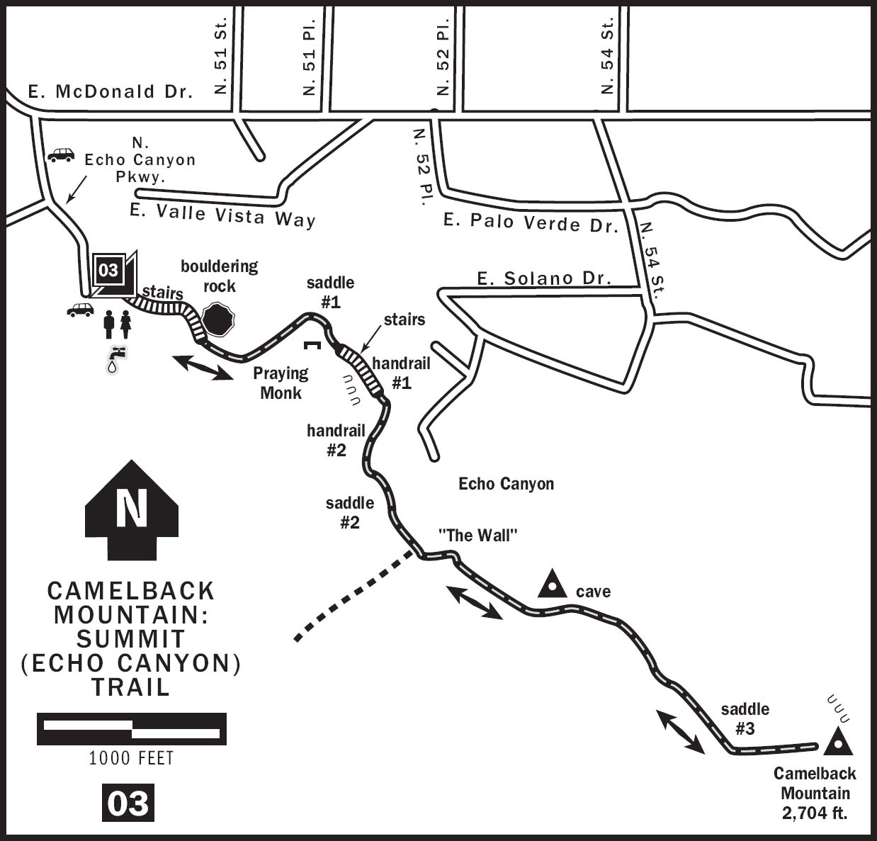
03 CAMELBACK MOUNTAIN: SUMMIT (ECHO CANYON) TRAIL
KEY AT-A-GLANCE INFORMATION
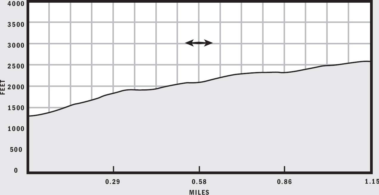
LENGTH: 2.2 miles
ELEVATION GAIN: 1,264 feet
CONFIGURATION: Out-and-back (an optional one-way hike down the Cholla Trail is 1.4 miles plus 0.5 miles to the parking area for the Cholla Trail)
DIFFICULTY: Difficult
SCENERY: Desert, sandstone cliffs, city panorama
EXPOSURE: Partial early-morning and late-afternoon shade, otherwise exposed
TRAFFIC: Heavy
TRAIL SURFACE: Rocky, stair-steps, boulders, handrail-assisted steep sections
HIKING TIME: 1.5 hours
WATER REQUIREMENT: 1–1.5 quarts
SEASON: Year-round; hot in summer
ACCESS: Open sunrise to sunset; free but very limited parking
MAPS: USGS Paradise Valley, trailhead plaque
FACILITIES: Portable toilets and water
DOGS: Yes, leashed at all times
COMMENTS: Parking is extremely limited at Echo Canyon Park. For more information, visit phoenix.gov/recreation/rec/parks/preserves/locations/camelback/index.html.
GPS Trailhead Coordinates
UTM Zone 12S
Easting 0409661
Northing 3709315
Latitude N33°31.283'
Longitude W111°58.410'
Directions
From Loop 202: Exit onto 44th Street and drive north 4.5 miles. Follow 44th Street as it bends eastward into McDonald Drive. As McDonald Drive bends north into Tatum Boulevard, turn east onto McDonald Drive, and then immediately turn south onto Echo Canyon Parkway. Parking is available inside Echo Canyon Park or along Echo Canyon Parkway.
From Loop 101: Exit onto McDonald Drive and drive west 5 miles to Echo Canyon Parkway.
IN BRIEF
Perhaps the best in-town hike in Phoenix, Camelback Mountain offers a central location, a rigorous climb of 1,264 feet to its summit, rugged sandstone cliffs, a 360-degree panoramic view from the top, and the chance to see a perfect sunset. Whether you’re a resident or visitor, this hike is a must-do.
DESCRIPTION
Named for its double-hump shape, Camelback Mountain resembles a giant sleeping camel in the middle of metropolitan Phoenix. Like an oasis of wilderness in a sea of housing developments and shopping centers, Camelback is a welcome respite from the hustle and bustle of urban life. There are two trails to the summit of Camelback Mountain. The popular Summit Trail, which is more commonly known as Echo Canyon Trail, runs up the western side, and the slightly easier Cholla Trail scales Camelback Mountain’s gentler eastern ridge.
The Summit Trail starts at the end of a small parking lot inside Echo Canyon Park. A drinking fountain, shaded benches, and portable toilets give hikers one last chance to prepare for the challenge ahead. The 1,264-foot climb to its summit is just over a mile in length but can humble all but the most accomplished athletes, so remember to take the hike at your own pace to avoid exhaustion. During summer, when the temperature soars above 100 degrees, consider splashing water on your clothing before starting the hike to keep cool. You will likely be completely dry again before reaching the summit.
Almost immediately, the trail climbs steeply up Echo Canyon in stadium-like steps. In February and March wildflowers dot the landscape along this section. Purple lupines, yellow brittlebush, and Mexican gold poppies stand in stark contrast against green grasses and red rocks. About 0.1 mile into the hike, the trail wraps around a large rock where many local climbers hone their bouldering skills. As you round this rock, the city fades away and the beauty of Echo Canyon engulfs you. Sheer cliffs and red sandstone formations reminiscent of Sedona frame your field of view. These rocks make up the sleeping camel’s head, which is relatively young compared to the metamorphic rock that comprises the rest of Camelback Mountain. At 0.2 miles, you top out on a small saddle where two cement benches greet you. Take a quick breather here to enjoy the view. The town of Paradise Valley lies straight ahead, and you can turn around to see the parking lot, already 250 feet below you. Above and to the right looms a famous rock formation known as the Praying Monk. Though it may not look like it from this vantage point, this formation actually resembles a person kneeling in prayer at the base of Camelback Mountain when seen from the East Valley.
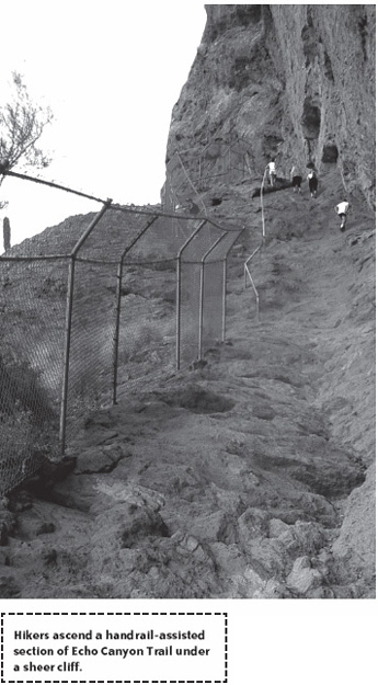
Continue your hike by following the obvious trail to the right, sandwiched between formidable cliffs and a chain-link fence shielding houses below from falling rocks and wandering hikers. After the stairs, approach a handrail-assisted scramble up a steep slope in the shadows of a towering precipice. Don’t worry; this part looks scarier than it really is. When eventually descending this section, however, remember that it may be easier to lower yourself down backward while facing uphill. One more handrail-assisted climb up some boulders, and you are done with the camel’s head at about 0.5 miles. From here, you are on your own. There are no more steps or rails to guide you. Traverse a small flat stretch in the trail; just before it climbs again the trail forks. The left fork takes you up the smooth rock face some locals call “The Wall,” while the right fork runs up a boulder-strewn gully. Bear right here and take the boulders unless you are surefooted enough to tackle a 45-degree incline.
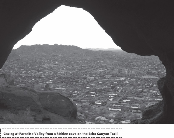
At the top of the gully, enjoy your first open view toward the south. The trail bends to the left and climbs relatively gently to a small saddle where a rock marker reads “3/4.” If you are adventurous, leave the trail here and turn left to visit the best-kept secret on Camelback Mountain. Skirt the right edge of the hill on your left and be careful with your footing. About 100 feet later, a small shallow cave presents itself. From the cave opening, you can rest and enjoy a secluded view of Paradise Valley’s many mansions and golf courses. Remember to duck when leaving the cave and returning to the trail.
What comes next is a long, steep section of boulder hopping. Just keep your head down and work your way slowly up this beast. If you need to take a break, do so at about 0.9 miles, where you have a view of a castle-like home to your right nestled into the mountainside. Right about here, the trail makes a nearly 90-degree bend to the left. On the way down, however, this little bend is not obvious, so make a mental note of where the trail is. By now your lungs and legs are probably burning, and you might be wondering when you are ever going to reach the top. Be aware that you cannot see the summit from here. The top of this steep section is a false peak, though it isn’t far from the true summit. The trail bends one last time to the left and ascends the final 0.1 mile to the 2,704-foot peak of Camelback Mountain.
The wide summit of Camelback can easily accommodate a large crowd and usually has one. Everyone from sweaty trail runners to camera-toting tourists is enjoying the view from the highest point in Phoenix. Who can blame them? From here, you command a sweeping 360-degree panorama of the Phoenix area. Take a well-deserved rest, and see if you can find the following landmarks in a clockwise survey of the landscape: the Phoenician Resort at the base of the mountain to the southeast, South Mountain, Sky Harbor International Airport, downtown Phoenix and Chase Field (formerly Bank One Ballpark), Piestewa Peak, McDowell Mountains, Four Peaks, Superstition Mountains, and the Cholla Trail running down the eastern ridge of Camelback. If you are lucky enough to hike Camelback at the right time on a partly cloudy day, you might also experience an amazing display of color. Nothing beats the silhouette of a saguaro cactus or an ocotillo plant against a brilliant Arizona sunset. Warning: Avoid dawdling because hiking down in near darkness can be treacherous.
After you have soaked up the scenery, return the way you came. Alternatively, you may descend the 1.4-mile Cholla Trail down the eastern ridge of Camelback Mountain. This option requires a car shuttle to Invergordon Road, the parking area for the Cholla Trail. The truly ambitious day hiker can attempt a “double crossing,” descending the Cholla Trail and then coming back up. Insane as it may seem, many locals make this double crossing a daily routine. Cross trainers sometimes jog the additional 3 miles from the Cholla Trailhead back to Echo Canyon Park.
NEARBY ACTIVITIES
Many upscale resorts and spas such as the Phoenician and Camelback Inn surround Camelback Mountain. The Indian Bend Wash Greenbelt, a system of parks, golf courses, bike paths, and lakes, lies 4 miles to the east along Hayden Road. Piestewa Peak, another popular urban hiking destination, sits 4 miles away to the northwest. The smaller Mummy Mountain is located directly north of Camelback Mountain.