Mt Aspiring National Park & Around Queenstown
Mt Aspiring National Park
Routeburn Track
Greenstone Caples Track
Rees-Dart Track
Cascade Saddle
Rob Roy Track
Gillespie Pass Circuit
Queenstown & Wanaka
Ben Lomond
Roys Peak
Diamond Lake & Rocky Mountain
Towns & Facilities
Queenstown
Wanaka
Glenorchy
Mt Aspiring National Park & Around Queenstown
Why Go?
Few places ignite a sense of adventure quite like Queenstown, Wanaka and Mt Aspiring National Park – even the sedentary get drawn into hitherto unconsidered activities here. But not everything here involves falling from a plane or a bridge. Head to Glenorchy, at the quiet end of Lake Wakatipu, and some of New Zealand’s finest mountain country awaits, including the Routeburn Track, the tramp many believe to be the greatest Great Walk of all. Just as enticing is the Matukituki Valley further north, providing a jaw-dropping gateway to hanging glaciers and airy passes.
For all that, you barely need leave Queenstown or Wanaka to get an eyeful of mountains as you tramp. Set out from near the centre of Queenstown and you can rise to lofty Ben Lomond, while Roys Peak, with its photo-perfect perch over Lake Wanaka, is Wanaka’s tramp of the day every day.
When to Go
The weather varies greatly across this region, with the mountains dictating the terms. Glenorchy is relatively dry, notching up around 1140mm of rain each year, with the lower Rees, Matukituki and Wilkin valleys not much wetter at around 1500mm. Head into the Route Burn and Dart valleys, and the western half of the Greenstone and Caples, and you can multiply that by around five. Snow can fall above 1000m in almost any month, and late winter and spring are high-risk times for avalanches.
The weather is generally settled from late December to March, with February often considered the best for tramping. However, when an alpine region you must be prepared for sudden changes in weather and unexpected storms at any time of year.
Best Views
Background Reading
Although much of the Queenstown area was originally settled in the quest for gold, this enterprise was quickly usurped by farming, with high-country stations scattered throughout the region. Many of today’s tramping tracks, such as the Greenstone and Caples, pass through them and follow old stock-droving routes along the valleys. High Country Legacy by Alex Hedley recalls the life and times of four generations of farmers at Mt Aspiring Station, while Iris Scott’s High Country Woman is the autobiographical tale of a widow (with three children) running the 1800-sq-km Rees Valley Station near Glenorchy. A read of these will certainly put the odd blister and sandfly bite into perspective.
DON’T MISS
Name your poison…in Queenstown, the so-called ‘adventure capital of the world’, you can pretty much set a flow meter on adrenaline. It was here that bungy jumping was famously pioneered by AJ Hackett Bungy (![]() %0800 286 4958, 03-450 1300; www.bungy.co.nz; The Station, cnr Camp & Shotover Sts), and today there are three jump sites around the town. When you’re done bouncing around on the end of a rubber band, there’s always skydiving, jetboating, river surfing (think rafting, but on a glorified boogie board), a high-powered ‘shark’ that leaps about the lake, heliskiing, paragliding and a more leisurely luge. A short stroll down Shotover St will lay it all out for you like an adventure buffet. Or you can simply slow down and ponder life and more mountains from the shores of Lake Wakatipu, where the view from Queenstown takes in the Remarkables, Cecil Peak and Walter Peak in one of the most beautiful mountain scenes in the country.
%0800 286 4958, 03-450 1300; www.bungy.co.nz; The Station, cnr Camp & Shotover Sts), and today there are three jump sites around the town. When you’re done bouncing around on the end of a rubber band, there’s always skydiving, jetboating, river surfing (think rafting, but on a glorified boogie board), a high-powered ‘shark’ that leaps about the lake, heliskiing, paragliding and a more leisurely luge. A short stroll down Shotover St will lay it all out for you like an adventure buffet. Or you can simply slow down and ponder life and more mountains from the shores of Lake Wakatipu, where the view from Queenstown takes in the Remarkables, Cecil Peak and Walter Peak in one of the most beautiful mountain scenes in the country.
Evenings in Queenstown are just as promising, with its restaurants turning out an enticing range of international cuisines, often driven by local produce. Complementing them is a selection of speciality bars focusing on the likes of craft beer, rum and fine wine.
DOC Visitor Centres
A DOC Visitor Centre (Queenstown)
Fast Facts
A Dominating the skyline is Tititea/Mt Aspiring (3033m), the highest peak in the country outside of the Aoraki/Mt Cook area.
A Queenstown and Wanaka lie on NZ’s third- and fourth-largest lakes, respectively. Lake Wakatipu is 283 sq km, and Lake Wanaka is 192 sq km.
A The 32km Routeburn Track, NZ’s second-most-popular Great Walk, is normally walked in three days. The 2017 winner of the Routeburn Classic race ran it in just over 2½ hours.
Top Tip
Queenstown is a honeypot for travellers, but Glenorchy and Wanaka make equally good (and quieter) bases for most of the tramps in the area.
Resources
MT ASPIRING NATIONAL PARK
Mt Aspiring National Park is a fitting end to the Southern Alps. It has wide valleys with secluded flats, more than 100 glaciers, and stark mountain ranges topped by 3033m Tititea/Mt Aspiring, NZ’s tallest mountain outside Aoraki/Mt Cook National Park.
The park stretches from the Haast River in the north to the Humboldt Mountains in the south, where it borders Fiordland National Park. The park is part of the Te-Wahipounamu–South West New Zealand World Heritage Area, which includes Aoraki/Mt Cook, Westland Tai Poutini and Fiordland National Parks.
At 3562 sq km, Aspiring is the country’s third-largest national park, with the majority of tramping activity taking place around Glenorchy, where trailheads for the famous Routeburn, Rees-Dart and Greenstone Caples tracks can be found. The tramping territory to the north, through the Matukituki and Wilkin-Young valleys, provides more mountain solitude.
History
Although there are traces of early settlement in this area, it’s thought that Māori primarily passed through on their way between Central Otago and South Westland where they sourced pounamu (greenstone), highly valued for its use in tools, weapons and taonga (treasure). Māori expeditions in search of pounamu are said to have been conducted as late as 1850 – about the same time the first Europeans began exploring the region.
In 1861 David McKellar and George Gunn, part explorers and part pastoralists, shed some light on the Greenstone Valley when they struggled up the river and climbed one of the peaks near Lake Howden. What they saw was the entire Hollyford Valley, which they mistakenly identified as George Sound in central Fiordland. The great Otago gold rush began later that year, and by 1862 miners were digging around the lower regions of the Dart and Rees Rivers, as well as in the Route Burn Valley.
A prospector called Patrick Caples made a solo journey up the Route Burn from Lake Wakatipu in 1863 and discovered Harris Saddle. He then descended into the Hollyford Valley and Martins Bay. Caples returned through the valley that now bears his name, ending a three-month odyssey in which he became the first European to reach the Tasman Sea from Wakatipu.
It was not until late in the 19th century that the first European crossed the Barrier Range from Cattle Flat on the Dart River to a tributary of the Arawata River. William O’Leary, an Irish prospector better known as Arawata Bill, roamed the mountains and valleys of this area and much of the Hollyford Valley for 50 years, searching out various metals and enjoying the solitude of these open, desolate places.
Mountaineering and a thriving local tourist trade began developing in the 1890s, and by the early 1900s it was booming, even by today’s standards. Hotels sprang up in Glenorchy, along with guiding companies that advertised horse-and-buggy trips up the Rees Valley. Sir Thomas Mackenzie, Minister of Tourism, pushed for the construction of the Routeburn Track and hired Harry Birley of Glenorchy to establish a route. In 1912 Birley ‘discovered’ Lake Mackenzie and the next year began cutting a track.
The famous track had reached Lake Howden by the outbreak of WWI, but the final portion wasn’t completed until the road from Te Anau to Milford Sound was built by relief workers during the Depression – until then a tramp on the Routeburn meant returning on the Greenstone Track.
The first move to make Mt Aspiring a national park came in 1935, but for all its beauty and popularity with trampers and tourists, the park wasn’t officially gazetted until 1964. Its legendary beauty landed the park and surrounds starring roles in The Lord of the Rings trilogy. The Mavora Lakes area, in particular, stole the limelight, being the scene of Silverlode and Anduin Rivers, Nen Hithoel, the edge of Fangorn Forest and south of Rivendell.
Environment
The landscape of Mt Aspiring National Park is largely glacial in origin. During the ice ages, massive glaciers carved into the metamorphic and sedimentary rock. As they retreated they left a sculpted landscape of U-shaped valleys, small hanging valleys and rounded cirques and ridges. The park still contains more than 100 glaciers, ranging from the large Bonar Glacier on the flank of Tititea/Mt Aspiring to the smaller ones that hang from the sides of the Matukituki Valley.
Beech forest dominates below the bushline, with each beech species favouring different growing conditions. The red beech thriving in the sunny valleys makes for semi-open forests and easy tramping, unlike the Fiordland forests with their dense, close understorey. Look out for ribbonwoods, one of NZ’s few deciduous trees. These are the first to colonise open areas caused by slips and avalanches. At higher altitudes you will find silver or mountain beech, while west of the Divide there’s rainforest of rimu, matai, miro and kahikatea.
In between the valleys are blooming mountain meadows that support one of the greatest ranges of alpine plants in the world. In alpine areas there are beautiful clusters of snow berry and coprosma in subalpine turf. In the Route Burn Valley, look for mountain daisies, snow grasses and veronica. Another beautiful plant of this region is the NZ edelweiss.
The forests are alive with native birds, including fantail, rifleman, bellbird, pigeon and cute South Island robin and tomtits. Along the rivers you may see whio (blue ducks) and paradise shelducks, and towards evening, moreporks and native bats, which are NZ’s only native land mammal. In alpine areas look out for the threatened rock wren and unmistakable kea.
Introduced animals include whitetail and red deer in lower areas and chamois about the mountaintops. Unfortunately, possums, rats and stoats are widespread. Introduced brown and rainbow trout are found in the lower Route Burn and brown trout are present in Lake Howden.
Routeburn Track
Duration 3 days
Distance 32km (19.9 miles)
Difficulty Moderate
Start Routeburn Shelter
End The Divide
Gateways Queenstown, Glenorchy, Te Anau
Transport Shuttle bus
Summary This most famous of alpine crossings is a best-of mountain compilation, and includes a breathtaking day above the bushline as you cross Harris Saddle.
The Routeburn is one of New Zealand’s best-known tracks, taking trampers over the Southern Alps’ Main Divide as it links Mt Aspiring and Fiordland National Parks. Much of it is through thick rainforest, where red, mountain and silver beech form the canopy, and ferns, mosses and fungi cover everything below like wall-to-wall shagpile carpet. It’s the alpine sections, however, that appeal most to trampers. Views from Harris Saddle (1255m) and the top of nearby Conical Hill take in waves breaking far below in Martins Bay, while from Key Summit there are expansive views of the Hollyford, Eglinton and Greenstone Valleys.
The tranquillity of the forest and meadows and the dramatic views of entire valleys and mountain ranges provide ample reward for the steep climbs and frequent encounters with other trampers. Indeed, the track’s overwhelming popularity resulted in the introduction of one of the first booking systems in New Zealand, in 1995. Independent walkers need to reserve their spot on the track before setting out – do so through Great Walks Bookings (![]() %0800 694 732; www.greatwalks.co.nz), or in person at DOC visitors centres nationwide. You must pick up your tickets at the Queenstown or Te Anau DOC visitors centres before heading out on the track.
%0800 694 732; www.greatwalks.co.nz), or in person at DOC visitors centres nationwide. You must pick up your tickets at the Queenstown or Te Anau DOC visitors centres before heading out on the track.
In summer be prepared for huts that are full, a constant flow of foot traffic and a small gathering of people admiring the views at Harris Saddle. The large number of people is more than offset by the mountain scenery, which is truly exceptional.
The considerable amount of climbing is tempered by the well-benched and graded track. A strong tramper could walk the track in less than three days, but considering the beauty of everything around you, why would you want to?
The track can be hiked in either direction, but most trampers begin on the Glenorchy side and end at the Divide. The trip can be made into a virtual circuit by turning at Lake Howden and joining either the Greenstone or Caples Tracks.
8Planning
WHEN TO TRAMP
The four huts on the Routeburn Track are well serviced from late October to late April. Outside this period the track is a winter crossing that should only be attempted by experienced trampers.
MAPS & BROCHURES
There are many maps for the Routeburn, but the best is the NZTopo50 CB09 (Hollyford). The track is also covered by NewTopo’s 1:40,000 Routeburn, Greenstone & Caples Tracks map. DOC’s Routeburn Track brochure includes a useful directory of transport operators and local businesses.
HUTS & CAMPING
All accommodation at huts and campsites must be booked in advance for any tramp from late October to late April. You must then stay on the nights booked, with rangers on duty to check that you’ve done so.
There are four huts on the Routeburn Track – Routeburn Flats, Routeburn Falls, Lake Mackenzie and Lake Howden – the most popular of which are Routeburn Falls and Lake Mackenzie, both near the bushline. All have gas rings for cooking.
During the Great Walks season, a night in a hut costs NZ locals/foreigners $65/130. Outside of the season, bookings are not required and the huts ($15) have limited facilities.
Camping (NZ local/foreigner $20/40) is permitted at Routeburn Flats and Lake Mackenzie, and at Greenstone Saddle (20 minutes from Lake Howden Hut), where it’s free.
Overnight use of Harris Shelter and the track-end shelters is not permitted.
INFORMATION
The DOC Visitor Centre (![]() %03-442 7935; www.doc.govt.nz; 50 Stanley St;
%03-442 7935; www.doc.govt.nz; 50 Stanley St; ![]() h8.30am-4.30pm) in Queenstown is the place to arrange logistics, obtain maps, passes and track updates and hire personal locator beacons. The Fiordland National Park Visitor Centre is close to the shores of Lake Te Anau and has friendly staff who can help with tramping arrangements, weather forecasts and info on track conditions. If you’ve booked online, you can pick up your hut or camping tickets at either office.
h8.30am-4.30pm) in Queenstown is the place to arrange logistics, obtain maps, passes and track updates and hire personal locator beacons. The Fiordland National Park Visitor Centre is close to the shores of Lake Te Anau and has friendly staff who can help with tramping arrangements, weather forecasts and info on track conditions. If you’ve booked online, you can pick up your hut or camping tickets at either office.
GUIDED TRAMPS
Ultimate Hikes (![]() %03-450 1940; www.ultimatehikes.co.nz; The Station, Duke St entrance;
%03-450 1940; www.ultimatehikes.co.nz; The Station, Duke St entrance; ![]() hNov-Apr) runs guided tramps on the Routeburn Track. Its three-day tramp features comfortable lodge accommodation, meals and expert interpretation. The trip starts from $1520 in high season (December to March) and $1375 in the low season (November and the first three weeks of April).
hNov-Apr) runs guided tramps on the Routeburn Track. Its three-day tramp features comfortable lodge accommodation, meals and expert interpretation. The trip starts from $1520 in high season (December to March) and $1375 in the low season (November and the first three weeks of April).
It also runs ‘Grand Traverse’ trips, a six-day combination of the Greenstone and Routeburn Tracks (high/low season from $2049/1810), with smaller groups and more rustic accommodation, but including a welcome rest day at Lake McKellar to soak up the wilderness atmosphere.
If you want an informed opinion for the great Milford-versus-Routeburn debate, Ultimate Hikes also operates ‘The Classic’ (high/low season from $3815/3505), tramping both tracks with a rest day between in Te Anau.
8Getting There & Away
Transport options are plentiful and varied for the Routeburn.
Glenorchy Journeys (![]() %03-409 0800; www.glenorchyjourneys.co.nz) runs shuttles to the Routeburn Shelter from Queenstown ($45) and Glenorchy ($25). Buses leave Queenstown at 8.15am, 11.30am and 1.45pm, returning from the Routeburn Shelter at 10am, noon and 4pm. Bookings required.
%03-409 0800; www.glenorchyjourneys.co.nz) runs shuttles to the Routeburn Shelter from Queenstown ($45) and Glenorchy ($25). Buses leave Queenstown at 8.15am, 11.30am and 1.45pm, returning from the Routeburn Shelter at 10am, noon and 4pm. Bookings required.
Info & Track (![]() %03-442 9708; www.infotrack.co.nz; 37 Shotover St;
%03-442 9708; www.infotrack.co.nz; 37 Shotover St; ![]() h7.30am-9pm) has three daily shuttles to the Routeburn Shelter from Queenstown ($49) and Glenorchy ($22). Its shuttle from the Divide to Queenstown ($81) departs at 10.10am and 3.15pm – you can throw in a Milford Sound cruise for an extra $78.
h7.30am-9pm) has three daily shuttles to the Routeburn Shelter from Queenstown ($49) and Glenorchy ($22). Its shuttle from the Divide to Queenstown ($81) departs at 10.10am and 3.15pm – you can throw in a Milford Sound cruise for an extra $78.
Buckley Track Transport (![]() %03-442 8215; www.buckleytracktransport.nz) has an 8am and 11am shuttle from Queenstown to the Routeburn Shelter ($45). A return shuttle from the Divide ($80) leaves for Queenstown at 2pm.
%03-442 8215; www.buckleytracktransport.nz) has an 8am and 11am shuttle from Queenstown to the Routeburn Shelter ($45). A return shuttle from the Divide ($80) leaves for Queenstown at 2pm.
Tracknet (![]() %0800 483 262; www.tracknet.net), based in Te Anau, runs frequent services from the Divide to Te Anau ($41), continuing on to Queenstown ($81).
%0800 483 262; www.tracknet.net), based in Te Anau, runs frequent services from the Divide to Te Anau ($41), continuing on to Queenstown ($81).
Trackhopper (![]() %021 187 7732; www.trackhopper.co.nz) provides a handy car-relocation service, driving you to the Routeburn Shelter and then shifting your car to the Divide ($270 plus fuel).
%021 187 7732; www.trackhopper.co.nz) provides a handy car-relocation service, driving you to the Routeburn Shelter and then shifting your car to the Divide ($270 plus fuel).
EasyHike (![]() %027 370 7019; www.easyhike.co.nz) also offers a car-relocation service (from $225). It can also kit you out for the tramp, offering a range of packages up to a ‘Premium’ service ($935) that includes booking your hut tickets, track transport, backpack, food, rain gear, cooking pots and first-aid kit.
%027 370 7019; www.easyhike.co.nz) also offers a car-relocation service (from $225). It can also kit you out for the tramp, offering a range of packages up to a ‘Premium’ service ($935) that includes booking your hut tickets, track transport, backpack, food, rain gear, cooking pots and first-aid kit.
Kiwi Discovery (![]() %03-442 7340; www.kiwidiscovery.com; 37 Camp St) services the Routeburn Track and has a range of options starting from $47 out of Queenstown. It also offers a five-night package (from $720) that includes transport to the track, hut booking, pre-tramp briefing, a cruise on Milford Sound at the end and accommodation in Queenstown the night before and after your hike.
%03-442 7340; www.kiwidiscovery.com; 37 Camp St) services the Routeburn Track and has a range of options starting from $47 out of Queenstown. It also offers a five-night package (from $720) that includes transport to the track, hut booking, pre-tramp briefing, a cruise on Milford Sound at the end and accommodation in Queenstown the night before and after your hike.
ROUTEBURN CLASSIC
If you’re short on time but not fitness, you could always consider the annual Routeburn Classic (race details are at http://goodtimesevents.net). Run (literally) in late April, the event sees the Routeburn Track turn into a running track, with athletes racing from the Divide to the Routeburn Shelter. The race has been held every year since 2001, and entries are limited to 350. As you set out walking on your third day along the Routeburn Track, consider this…the race record over the 32km is just a bit over 2½ hours.

kThe Tramp
Day 1: Routeburn Shelter to Routeburn Falls Hut
4 HOURS / 8.8KM / 560M ASCENT
The track begins with a crossing of Route Burn on a swing bridge to its true left (north) bank, before winding for 1km through a forest of red, silver and mountain beech to a footbridge over Sugar Loaf Stream. The forest here is magnificent, with red beech trees towering overhead. Once across the stream the track climbs gently for 20 minutes until it reaches a swing bridge over the small gorge carved by Bridal Veil Falls. More impressive rock scenery follows as the track sidles Routeburn Gorge, providing ample opportunities to peer into the deep pools at the bottom. The dramatic views end at Forge Flats, a gravel bar along a sharp bend in the Route Burn and a popular place to linger in the sun.
Just beyond the flats, the track uses a long swing bridge to cross to the true right (south) side of the Route Burn and heads back into bush, where it skirts the grassy flats. It’s an easy 30-minute stroll along a level track through the bush to a signposted junction, where the right fork leads to Routeburn Flats Hut (20 bunks), five minutes away. The hut overlooks the river, the wide grassy flats and the mountains to the north. Around 200m on is Routeburn Flats campsite.
The main track (left fork) begins a steady ascent towards Routeburn Falls Hut. The track climbs 270m over 3km (about 1½ hours) before reaching the hut above the bushline. Emily Creek footbridge is the halfway point of the climb, and just beyond it the track sidles a steep rock face called Phoenix Bluff. The track soon crosses a huge slip, where a massive 1994 flood sent trees crashing towards the flats below. The resultant forest clearing affords magnificent views of the valley and surrounding peaks.
From the slip you resume the steady but rocky climb to Routeburn Falls Hut (48 bunks), the scene of many comings and goings. The hut is right at the tree line (1005m) and its long veranda offers views of the flats and the surrounding Humboldt Mountains. Right behind the hut is a private lodge for guided trampers. There’s no camping around this hut and wardens are strict about enforcing this rule.
Day 2: Routeburn Falls Hut to Lake Mackenzie
4–6 HOURS / 11.3KM / 215M ASCENT, 355M DESCENT
From the hut it’s a short climb to the impressive Routeburn Falls, which tumble down a series of rock ledges. Once on top of the falls the track cuts across an alpine basin towards the outlet of Lake Harris. The walk is fairly level at first, crossing a couple of bridges and then beginning a steady climb. You pass beneath a pair of leaning boulders, ascend more sharply and then arrive at Lake Harris. Sore legs and aching muscles are quickly forgotten as the stunning view of the lake materialises, especially on a clear day, when the water reflects everything around it. Carved by a glacier, Lake Harris is 800m long and 500m wide. In winter it freezes over and chunks of ice are often seen floating on the lake when the Routeburn Track opens for the season in October.
The track works its way around the lake along bluffs and moraines. You get a second jolt 1½ to two hours from the hut, when entering the grassy meadows of Harris Saddle. From this 1255m vantage point, part of the Hollyford Valley comes into view, almost to Martins Bay if the weather is clear. If you are blessed with such weather, drop your packs and climb the steep side track to Conical Hill (1½ hours return). The 360-degree view from the 1515m peak includes the Darran Mountains, Richardson Range (in Otago) and the entire Hollyford Valley.
Positioned on the boundary between Mt Aspiring and Fiordland National Parks, the Harris Saddle emergency shelter is a popular stopping place. The track begins its descent towards the Hollyford Valley on wooden steps and then turns sharply south. For the most part the track here is narrow but level, clinging to the Hollyford face of the ridge, high above the bushline. A strong tramper could probably walk from the saddle to Lake Mackenzie in less than two hours, but why rush? This is the best part of the trip, a stretch where you need to stop often and soak up the incredible alpine scenery.
After 30 minutes the track arrives at a signposted junction with Deadman’s Track, an extremely steep route to the floor of the Hollyford Valley (five hours). The immense views continue, and 2km from the junction with Deadman’s Track the route crosses a swing bridge over Potters Creek. In another 30 minutes you can see the cabins of Gunn’s Camp at the bottom of the Hollyford Valley, directly below you.
Two hours from the saddle the track rounds a spur to the east side of the ridge and Lake Mackenzie comes into sight. The lake is a jewel set in a small, green mountain valley, and the hut is clearly visible on the far shore. The track zigzags down to the lake, dropping sharply for the final 300m. It then skirts the bush and arrives at Lake Mackenzie Hut (50 bunks), a two-storey building overlooking the southern end of the lake. There are bunks on the 2nd floor of the hut, and additional beds in a separate bunk room. Because of the fragile nature of the lakeshore and the alpine plants, the Lake Mackenzie campsite is a small facility, but it does have toilets, a water supply and a cooking shelter. The lake doesn’t have a conventional outlet, so don’t wash or bathe in it.
Day 3: Lake Mackenzie to the Divide
4–5 HOURS / 12KM / 380M DESCENT
The track begins in front of the hut, passes the lodge for guided trampers and enters the bush. You begin with a level walk, crossing several swing bridges over branches of Roaring Creek, and within 15 minutes begin climbing. The climb regains the height lost in the descent to Lake Mackenzie, and is steady but not steep.
About 40 minutes to one hour from the hut, the track breaks out at a natural clearing, known as the Orchard, where a handful of ribbonwoods resemble fruit trees. The view of the Darran Mountains is excellent.
More alpine views are enjoyed for the next hour or so, as the track passes through several avalanche clearings in the forest. Eventually you descend to Earland Falls, a thundering cascade that leaps 174m out of the mountains. On a hot day this is an ideal spot for an extended break, as the spray will quickly cool you off. If it’s raining the falls will be twice as powerful and you might have to use the flood route, which is signposted along the main track.
The track steadily descends and after 3km emerges at Lake Howden. This is a major track junction and during the peak season it resembles Piccadilly Circus, with trampers and guided walkers going every which way: the Routeburn Track is the right fork (west); the Greenstone Track is the left fork (south). If you’re planning to spend an extra night on the track, you can either stay at Lake Howden Hut (28 bunks) on the shores of the beautiful lake, or camp near the south end of the lake by following the Greenstone Track for 20 minutes to Greenstone Saddle.
The Routeburn Track swings past the flanks of Key Summit and in 15 minutes comes to a junction. If you’re not racing to catch a bus, the 30-minute side trip (left fork) to the top is worth it on a clear day – from the 919m summit you can see the Hollyford, Greenstone and Eglinton Valleys, and there are some crazy stunted beech trees and sphagnum bogs to marvel at.
From the junction the Routeburn Track descends steadily to the bushline, where thick rainforest resumes, before reaching the Divide, the lowest east–west crossing in the Southern Alps. It’s 3km (one hour) from Lake Howden to the Divide, where there is a huge shelter with toilets and a car park. Buses and vans are constantly pulling in here on their way to either Milford Sound or Te Anau. Welcome back to civilisation.
Greenstone Caples Track
Duration 4 days
Distance 61km (37.9 miles)
Difficulty Moderate
Start/End Greenstone car park
Gateways Queenstown, Glenorchy
Transport Shuttle bus
Summary These connecting tracks loop through a pair of valleys between Lake Wakatipu and the Divide, providing a glimpse of World Heritage–listed wilderness between Queenstown and the Routeburn Track.
From the shores of large Lake Wakatipu, this scenic tramp circuits through the Caples and Greenstone Valleys, crossing the subalpine McKellar Saddle, where it almost intersects with the Routeburn Track.
The name of the Greenstone Valley hints at this valley’s ancient use as a route for Māori to access the Dart Valley to collect highly prized pounamu (greenstone), though no Māori archaeological sites have been found in the Greenstone and Caples Valleys themselves. Europeans would later traverse the valleys in search of grazing sites, with farming commencing in the Caples in 1880. The Greenstone and Pass Burn were utilised as stock routes.
The Greenstone Valley is wide and open with tussock flats and beech forest. The Caples is narrower and more heavily forested, interspersed with grassy clearings. Many trampers consider the Caples, with its parklike appearance, to be the more beautiful of the two.
The two tracks link at McKellar Saddle and again near Greenstone car park, where the road links to Glenorchy and on to Queenstown. Trampers can choose to walk just one track in one direction (joining the end of the Routeburn Track down to the Divide), or traverse both as a there-and-back journey of four days. Routeburn trampers planning to continue on the Greenstone can easily walk from Lake Mackenzie Hut to McKellar Hut, which takes around five to seven hours.
8Planning
WHEN TO TRAMP
The Greenstone Track is a low-level route and can be tramped year-round. The Caples, however, climbs over the subalpine McKellar Saddle (945m) and therefore should be avoided in winter, except by those with experience and equipment for cold, snow and ice. The ideal time to tramp this route is November to April.
MAPS & BROCHURES
Maps required for the entire loop are NZTopo50 CB9 (Hollyford), CB10 (Glenorchy) and CC9 (North Mavora Lake). The track is also covered by NewTopo’s 1:40,000 Routeburn, Greenstone and Caples Tracks.
DOC’s brochure for the tramp is Greenstone Caples Track.
HUTS & CAMPING
There are three Serviced huts ($15) between the two tracks: Mid Caples, McKellar and Greenstone. They all have heating, but no stoves, and rangers are likely to be in the vicinity from late October until mid-April. Obtain hut tickets from DOC visitors centres nationwide.
Camping is permitted next to the huts ($5) and along the bush edge through the valleys, though you must be at least 50m from the track. Camping isn’t permitted on McKellar Saddle or in open areas along the valleys.
Upper Caples Hut ($25), once managed by DOC, is now owned and managed by the NZ Deerstalkers Association (http://southernlakesnzda.org.nz/huts). Trampers can stay here, but need to book ahead through their website.
INFORMATION
The DOC Visitor Centre in Queenstown is the place to arrange logistics, obtain maps, hut tickets and track updates, and hire personal locator beacons. The Fiordland National Park Visitor Centre is close to the shores of Lake Te Anau and can help with all tramping arrangements, weather forecasts and info on track conditions.
GUIDED TRAMPS
Ultimate Hikes runs a six-day ‘Grand Traverse’ tramp (from $1810) along the Greenstone Track and across the Routeburn Track.
8Getting There & Away
Glenorchy Journeys offers daily scheduled shuttle services to Greenstone car park from Queenstown ($55, 8.15am, 11.30am and 1.45pm) and Glenorchy ($35, 7am, 9am and 12.30pm). Shuttles return from the Greenstone car park at 10am, noon and 4pm. Bookings are essential.
Info & Track runs shuttles to Greenstone car park from Queenstown ($54, 8am) and Glenorchy ($37, 9.15am). The return shuttle departs from Greenstone at noon. Buckley Track Transport has an 8am shuttle from Queenstown to Greenstone car park ($55), with return shuttles departing for Queenstown at noon.
If you’re tramping the Greenstone or Caples and exiting at the Divide, Trackhopper provides a handy car-relocation service, driving you to the Greenstone car park and then shifting your car to the Divide ($285). There are also shuttle-bus services to the Divide.
kThe Tramp
Day 1: Greenstone Car Park to Mid Caples Hut
2½ HOURS / 9KM
The track departs the car park and in a few minutes passes a junction where the left fork leads to a bridge across the Greenstone River. Don’t cross the bridge – remain on the true left (north) side of the Greenstone River, pass the confluence with the Caples River and, 30 minutes from the car park, you’ll arrive at a signposted junction. Here the Greenstone Track heads southwest, quickly crossing a swing bridge over the Caples.
The Caples Track continues along the true left side of the Caples River, but stays in beech forest above the valley to avoid crossing Greenstone Station. At one point the woolshed of an old homestead may be spotted on the far bank.
It’s about 2½ hours along the east bank before the well-marked track descends past an impressive gorge and crosses a bridge over the Caples to Mid Caples Hut (24 bunks) on an open terrace above the river.
Day 2: Mid Caples Hut to McKellar Hut
6–7 HOURS / 22KM
From Mid Caples Hut the track remains on the true right (west) side of the river and crosses open grassy flats for the first hour. You then ascend into beech forest to round a small gorge before quickly returning to the flats.
Eventually the track turns into bush before it emerges at the southern end of Top Flat. It takes about 25 minutes to cross the flat and cut through more beech forest. Just before Upper Caples Hut is a signposted junction with the Steele Saddle route south to the Greenstone Track, an extremely difficult tramp (10 to 12 hours).
Upper Caples Hut (1½ to 2½ hours from Mid Caples Hut) is on a grassy flat where the valley begins to narrow. It has a beautiful setting, with the Ailsa Mountains rising directly behind the hut. The hut is owned by the NZ Deerstalkers Association, and if you wanted to spend the night here, it can be booked ahead through them.
Past the hut, the track leaves the valley floor and climbs towards McKellar Saddle. At first the track is quite rough, with exposed tree roots and rocks, but becomes easier after an hour as it sidles up towards the bush edge.
Two hours from the hut it reaches McKellar Saddle (945m), an extremely wet and boggy area crossed by boardwalks built to protect the fragile subalpine vegetation. The views are good from the saddle – on a clear day the peaks and hanging valleys of Fiordland can be seen to the west.
Leaving the saddle, the track descends at an easy grade to a point where you break out of the bush near the head of Lake McKellar. Here, the track swings north to bypass swampy lowlands, then crosses a bridge to meet up with the Greenstone Track.
The Greenstone Track heads south (left) and crosses the grassy flat, where you’re treated to views of Lake McKellar. It then gently climbs the forested edges of the lake, a couple of times dipping close enough for you to scout for cruising trout, but mostly skirting the hillsides, where views are limited to keyhole glimpses through the trees. McKellar Hut (24 bunks) sits in a small clearing next to the Greenstone River, with the rocky face of Jean Batten Peak (1971m) looming overhead.
WARNING: HEAVY RAIN
The upper Caples River can rise extremely fast during periods of heavy rain. You’ll cross a number of unbridged side streams along the track between the Upper Caples Hut and the junction with the Greenstone Track, and caution should be used when tramping this stretch during foul weather.
Alternative Finish: Lake McKellar to the Divide
2–3 HOURS / 6.5KM
If you’re not completing the loop on the Greenstone Track, your cue to head to the Divide comes when the Caples Track meets with the Greenstone Track by Lake McKellar. Take the right fork, heading north. After 45 minutes to one hour, you’ll reach beautiful Lake Howden then Lake Howden Hut (28 bunks). At the hut you’ll see a major track junction. Turn left (west) along the Routeburn Track, passing the flanks of Key Summit and another trail junction. The 30-minute side trip (left) to the top of Key Summit is worthwhile on clear days – from the 919m summit, you should be able to see the Hollyford, Greenstone and Eglinton Valleys.
From the Key Summit junction, the Routeburn Track descends steadily through bush and thick rainforest, before reaching the Divide, the lowest east–west crossing in the Southern Alps. It’s 3km (one hour) from Lake Howden Hut to the Divide, where there’s a car park and a shelter with toilets and water.
Side Trip: Peak 1538
6–8 HOURS / 17KM / 920M ASCENT
If you have a spare day at McKellar Hut, an interesting day walk is to climb Peak 1538 just southwest of the hut. Departing from the ‘McKellar Hut’ sign on the way towards Lake Howden Hut, is an unmarked track that climbs to the bushline. From there it’s a steep climb through the alpine tussock to the top of Peak 1538. You can then follow the ridge to Key Summit (919m), descend to Lake Howden Hut and follow the first leg of the Greenstone Track back to McKellar Hut.
Day 3: McKellar Hut to Greenstone Hut
4½–6½ HOURS / 18KM
This day is spent tramping through the heart of the Greenstone Valley, where you’ll see lots of cattle and, if you’re wearing polarised sunglasses, a few of the river’s famous trout.
The track immediately crosses the Greenstone River on a bridge in front of the hut to the true left (east) side. You then cut through beech forest for 30 minutes (1.5km), emerging at the northern end of Greenstone Flats, which are dominated by Jean Batten Peak.
The track cuts across bulrush grass and then returns to bush for almost 2km, skirting the Greenstone River, which boasts many beautiful pools. After crossing a large grassy flat, the track moves higher onto the forested bluffs.
For the next three hours the track stays predominantly in bush above the open valley. There’s an occasional stretch of rocks and roots, but for the most part the track is a straightforward tramp with little climbing. When you emerge onto a large open flat you’ll soon spot private Rat’s Nest Hut on the opposite bank of the river.
You remain in grassy flats until the track ascends around a gorge. Short side trails allow you to peer down between the rock walls at the roaring Greenstone River, before the track descends to Steele Creek and a major swing bridge. Just before the bridge is a signposted junction with a track heading north (left fork) to Steele Saddle and Upper Caples Hut, a demanding tramp of 10 to 12 hours. On the other side you break out of the trees and cross a grassy terrace to a signposted junction. The left fork heads off to a private hut for guided trampers. Right above you is the Mid Greenstone Hut, another club hut for the NZ Deerstalkers Association.
The right-hand fork descends to open flats for the next 3km. Re-enter the bush across from the confluence of the Greenstone River and Pass Burn; the hut on the other side of the river is private. The track now begins to skirt around Greenstone Gorge and, after 2km, comes to a junction with a track to Greenstone Hut. It’s a five-minute descent to the bridge across the Greenstone River, from where there’s a good view of the narrow rock walls of the gorge. Another 10 minutes from the swing bridge is Greenstone Hut (20 bunks) and the northern end of the Mavora–Greenstone Walkway. This is a great hut with a huge kitchen and wrap-around deck that peers out onto the surrounding mountains.
Day 4: Greenstone Hut to Greenstone Car Park
3–5 HOURS / 12KM
Begin the day by recrossing the bridge over the gorge and returning to the Greenstone Track. Head right on the main track as it continues on the true left (north) side of the river. You climb high above the gorge, and then swing left with the valley before crossing Slip Creek on a bridge and entering the western end of Slip Flat, 40 minutes to one hour from Greenstone Hut.
It’s 1km across the flats before you re-enter the bush close to the river. After 20 to 30 minutes the track crosses a stream and comes to a signposted junction. The track to the east (right) stays close to the river before crossing a stock bridge and heading for Lake Rere (one hour). Take the main track to the north (left) instead, which remains on the true left (north) side of the river and climbs through the rest of the gorge.
About 1½ to two hours from the gorge, the track reaches a swing bridge over the Caples River, after which you will see a signposted junction.
Take the right fork (if you started this walk at the Divide, take the left fork onto the Caples Track to complete the loop) and follow the track along the true left bank of the Greenstone River. It will take 30 minutes to reach the trailhead at the Greenstone car park.
GREENSTONE & TROUT
Early European settlers to New Zealand, wishing to improve the country’s farming, hunting and fishing opportunities, were responsible for the introduction of such ghastly wreckers as possums and rabbits. One of their more successful introductions was that of trout – brown and rainbow – released into NZ rivers in the second half of the 19th century.
Today they’re much prized by anglers, whom you may stumble across, thigh-deep in limpid rivers or on the edge of deep green pools, flicking their flies. It’s a pastime that, to its participants, often borders on obsession.
The Greenstone River is one of NZ’s most-lauded trout fisheries. Accessible only on foot along the Greenstone Track (or by helicopter), the luminous green river boasts plentiful fish (both brown and rainbow trout) of legendary size, averaging between 1.5kg and 3kg. As you tramp alongside the river, keep an eye on the pools because you may well spot a few trout seemingly suspended in the clear water.
Trout fishing is highly regulated, with licences required to fish anywhere in NZ. Licences and information can be obtained from Fish and Game New Zealand (www.fishandgame.org.nz). If you’re new to the sport, your best bet will be to go with a local guide; i-SITEs can help you find one. Otherwise, peruse the helpful online guide NZ Fishing (www.nzfishing.com).
Rees-Dart Track
Duration 4 days
Distance 63km (39.1 miles)
Difficulty Moderate to demanding
Start Muddy Creek car park
End Chinamans Flat
Gateway Glenorchy, Queenstown
Transport Shuttle bus
Summary Alpine scenery, wild rivers and a possible day trip to Dart Glacier have made the Rees-Dart one of the most popular tracks in Mt Aspiring National Park.
The Rees-Dart Track connects two splendid schist-lined valleys shaped by glaciation. The relatively small Dart Glacier was once part of an enormous system that terminated at Kingston, 135km away at the southern end of Lake Wakatipu.
As this tramp winds up one valley and back down the other, it takes in a variety of scenery, such as meadows of flowering herbs and mighty bluffs and moraine walls.
Pinched between the Routeburn Track and Cascade Saddle, the Rees-Dart has become a popular tramp, but it is longer and definitely more challenging than either the Routeburn or Greenstone Caples, and has several stream crossings, which can be hazardous in heavy rain or snowmelt.
The most common approach to the tramp is to head up the Rees Valley and return down the Dart – this is the easiest direction in which to climb Rees Saddle and the way we describe the tramp. Plan an extra night at Dart Hut if you want to include a day trip to Dart Glacier or even on to Cascade Saddle.
8Planning
WHEN TO TRAMP
The best time to tramp the Rees-Dart is December to April. From late winter through to early summer, the high sections of the route are subject to avalanches, with snow often lingering as late as December.
MAPS & BROCHURES
This tramp is covered by NZTopo50 maps CA10 (Lake Williamson) and CB10 (Glenorchy), as well as NewTopo’s 1:40,000 Rees-Dart Track. Pick up DOC’s The Rees-Dart Track brochure.
HUTS & CAMPING
There are three Serviced huts ($15) on this tramp: Shelter Rock, Dart and Daleys Flat. Each has a solid-fuel fire and water but no cooking facilities, so it’s essential that you carry a stove.
You can camp next to the huts for $5, and elsewhere on the route with the exception of the fragile alpine and subalpine areas between Shelter Rock and Dart Huts.
Be sure to purchase your hut tickets in advance from any DOC visitors centre.
INFORMATION
The DOC Visitor Centre in Queenstown is the place to arrange logistics, obtain maps, hut tickets and track updates, and hire personal locator beacons.
8Getting There & Away
Glenorchy Journeys offers daily shuttle services to Muddy Creek from Queenstown ($55, 8.15am, 11.30am and 1.45pm) and Glenorchy ($35, 7am and 9am). Shuttles return from Chinamans Flat at 2pm and 4pm. Bookings are essential.
Info & Track runs shuttles to Muddy Creek from Queenstown ($54, 8am) and Glenorchy ($37, 9.15am). The return shuttle departs from Chinamans Flat at 2pm.
Trackhopper will drive you to Muddy Creek and deliver your car to Chinamans Flat, ready for you at the end of the tramp, for $160.
It used to be common to end this tramp with a jetboat pick-up as high up the river as Sandy Bluff, but changes to the river after the 2014 slip here have now made this impossible.
kThe Tramp
Day 1: Muddy Creek Car Park to Shelter Rock Hut
6–8 HOURS / 19KM
From Muddy Creek car park, ford the creek and head across the private farmland of Rees Valley Station for 2km, reaching the private Arthurs Creek Hut just beyond Bridges Creek. Grassy flats lie beyond, and it’s one hour (4km) of open travel on the true left (east) side of Rees River until the track crosses a bridge over Twenty Five Mile Creek; poles mark the route.
The route continues along open river flats for another 1½ hours and can be extremely muddy at times – almost knee-deep in spots if it’s been raining. Eventually you reach a track marked by a park boundary sign, and enter the bush. Within 500m the track crosses a swing bridge to the true right (west) side of Rees River. The track continues on this side of the river, passes through Clarke Slip, over grassy flats, and then begins a climb through beech forest. Within 2km the track passes the site of the old Shelter Rock Hut, now used occasionally as a campsite. From here it’s 1km along the true right (west) bank of the Rees, through stands of stunted beech, before the track crosses a swing bridge back to the true left (east) bank to arrive at Shelter Rock Hut (22 bunks).
Day 2: Shelter Rock Hut to Dart Hut
4–6 HOURS / 10KM / 490M ASCENT
The climb over alpine Rees Saddle begins by following the river on the true left (east) side for a short time, picking up a well-marked track that rises through alpine scrub. The track gradually sidles up the valley until it reaches a tussock basin below the saddle, about 4km from the hut.
Rees Saddle is the obvious low point to the northeast. You keep to the stream bed before climbing up the steep slope to the top. The final ascent is marked with orange poles and a well-beaten path, but is still a steep climb. As you would expect of a 1471m-high pass, Rees Saddle provides great views of the surrounding peaks and valleys, making it the natural place for lunch if the weather is clear.
Follow the orange poles from the saddle towards Dart Hut. You quickly descend 90m to a terrace and a group of tarns above Snowy Creek. The track traverses steep, snow-grass slopes, which can be dangerous when wet or covered with snow.
The route stays on the true left (west) of Snowy Creek, then drops suddenly to a footbridge and crossing to the true right (east) side. This steep-sided creek fills with so much snow during the winter that DOC must remove the bridge in advance, or risk losing it to an avalanche. The track climbs above the bridge, passes some good views of the upper Dart Valley, and descends across broken slopes of rock and shrub.
Dart Hut is visible on the true left (south) bank of the Dart River during the final descent, which ends at a swing bridge across Snowy Creek. The camping spots just before the bridge signal that the hut is five minutes away.
Many trampers spend two nights at Dart Hut (32 bunks) so they can hike to view Dart Glacier. This has the tendency to create a bottleneck at the hut at the height of the tramping season.
Side Trip: Dart Glacier
4–6 HOURS RETURN, 14KM
The popular and rewarding hike to view Dart Glacier is strenuous and challenging and should only be attempted in good weather, and only by those confident navigating unmarked routes over steep terrain.
Cross the Snowy Creek bridge and follow the poles and rock cairns along the Dart River and the edge of Dart Glacier. After about three hours you will begin to climb moraine and tussock slopes with increasingly impressive views of the glacier and the Snowdrift Range to the west.
If conditions are ideal, and you have the energy, you can push on to Cascade Saddle (eight to 10 hours return from Dart Hut, 20km).
Day 3: Dart Hut to Daleys Flat Hut
5–7 HOURS / 18KM
The track climbs west, away from the hut and along a bluff above the Dart River, offering an occasional view of the rushing water below or the valley in front as it passes through thick forest.
Around 6km into the day, the track climbs sharply, but then drops into a rocky stream clearing near the eastern end of Cattle Flat. The track quickly emerges from forest onto the flat, a seemingly endless grassy area where the trail appears as a path of trampled grass marked occasionally by a rock cairn. The Dart River is seen as you cross the flat, as is a portion of Curzon Glacier, high in the mountains across the river. The track follows the middle of the flat and in 3km passes a sign to a rock bivvy. The bivvy, a three-minute walk up a side track, is a huge overhanging rock that can easily hold at least six people. If it’s raining this is an excellent place for lunch.
The track continues across Cattle Flat for another 1.5km and finally returns to the bush. From here it’s another 1½ to two hours to Daleys Flat Hut. You begin with a steady drop towards the river, reaching the banks of the Dart in 2.5km. Along the way you pass another rock bivvy, much smaller than the one at Cattle Flat. Eventually the track breaks out at Quinns Flat, a beautiful stretch of golden grass surrounded by mountains, and then returns to the bush.
The track crosses a few more streams and, in 30 minutes, arrives at Daleys Flat. Follow the trampled grass across the flat to reach Daleys Flat Hut (20 bunks).
Day 4: Daleys Flat Hut to Chinamans Flat
5½–7½ HOURS / 16KM
From the hut, the track heads through beech forest for about an hour to a recently formed, 3km-long lake over Dredge Flat. This lake was created in 2014 after a massive landslide poured down into the valley. The track was closed for three years, but reopened in March 2017, with almost 3km of the route realigned.
From the lake, the new track heads up high above the Dart River on sections of track that are narrow and sometimes steep, adding about 1½ hours to the walk as it previously existed.
Eventually the track enters an open flat, with Chinamans Bluff straight ahead and an impressive waterfall from Lake Unknown visible high in the mountains across the Dart River.
The track skirts the bluff and descends onto Chinamans Flat. Skirt yet another bluff, this one along a segment of track that provides access around a washed-out area to the start of a 4WD track where you’ll find a shelter, toilets and an information panel. If you haven’t arranged a pick-up, it’s still another 6km to the end of Glenorchy Paradise Rd – a good two-hour tramp along the 4WD track through Dan’s Paddock.
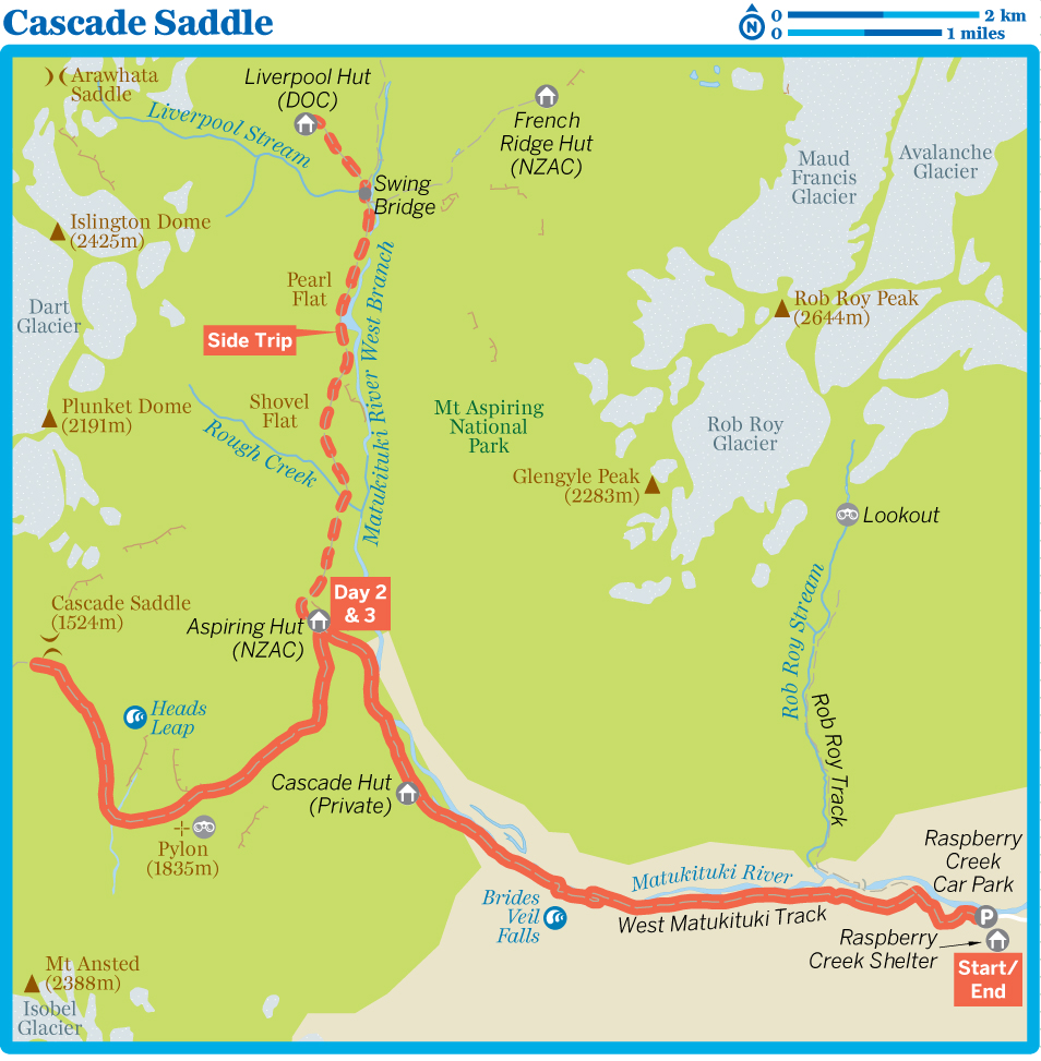
Cascade Saddle
Duration 3 days
Distance 30km (18.6miles
Difficulty Demanding
Start/End Raspberry Creek car park
Gateway Wanaka
Transport Shuttle bus
Summary Climb to one of the most scenic alpine passes in the country for stunning views of Tititea/Mt Aspiring and the Dart Glacier, and to test your head for heights.
Cascade Saddle is one of the most beautiful and dramatic of all the passes that trampers can reach in NZ. Pinched between the West Matukituki and Dart Valleys, it’s a very steep and demanding climb. On a fine day, the rewards are as numerous as the mountains you can see from atop the alpine pass, including a stunning view of Tititea/Mt Aspiring.
Cascade Saddle can also be reached from Dart Hut on the Rees-Dart Track, providing an enticing opportunity for a four-day tramp, crossing the pass from the West Matukituki Valley and exiting along the Dart Valley. The easiest approach is from the West Matukituki, as described here.
The West Matukituki is tramping royalty in the South Island, and it’s worth building in a couple of extra days to explore upstream to Liverpool Hut, and take a detour out to Rob Roy Glacier. You could easily while away a decent week based at Aspiring Hut, branching out on day walks and soaking up the spectacular mountain scenes.
Be warned: Cascade Saddle is a difficult climb, partially smothered in super-slippery snow grass, and trampers have fallen to their deaths here. It should not be attempted by inexperienced trampers, or in adverse conditions. If you have any doubts, seek advice from the warden in Aspiring Hut, who will have current weather forecasts on hand.
8Planning
WHEN TO TRAMP
Though you can hike through the West Matukituki Valley pretty much all year in favourable conditions, Cascade Saddle is a high alpine pass and should only be attempted when it’s free of snow, normally from December to March. Even then, sudden cold fronts can sweep through and bring snow and fierce conditions at any time. It’s also infamous for cloud, which can create white-out conditions for trampers.
MAPS & BROCHURES
The tramp is covered by NZTopo50 CA11 (Aspiring Flats) and CA10 (Lake Williamson). DOC’s Cascade Saddle Route brochure gives an overview of the tramp, though it’s not as comprehensive as brochures for some other trails.
HUTS & CAMPING
Aspiring Hut (members/non-members $15/30) is a New Zealand Alpine Club (NZAC) hut that’s managed by DOC. Fees can be paid at the Tititea/Mt Aspiring National Park Visitor Centre in Wanaka, or online via the NZAC website (https://alpineclub.org.nz).
There’s a designated camping area ($5) adjacent to Aspiring Hut that’s equipped with a shelter and toilet for campers – people choosing to camp can’t use the hut facilities. Camping fees can only be paid at the Tititea/Mt Aspiring National Park Visitor Centre; the hut warden is likely to check for your receipt.
Note that there were plans to close Aspiring Hut for an indefinite time in 2018 for earthquake-strengthening work, so check ahead on its status through the NZAC website before setting out. The tiny Liverpool Hut is a Serviced hut ($15).
INFORMATION
DOC’s Tititea/Mt Aspiring National Park Visitor Centre (![]() %03-443 7660; www.doc.govt.nz; cnr Ardmore St & Ballantyne Rd;
%03-443 7660; www.doc.govt.nz; cnr Ardmore St & Ballantyne Rd; ![]() h8.30am-5pm daily Nov-Apr, Mon-Sat May-Oct) in Wanaka can provide full information and take hut bookings. It also has museum-style displays on local geology, flora and fauna.
h8.30am-5pm daily Nov-Apr, Mon-Sat May-Oct) in Wanaka can provide full information and take hut bookings. It also has museum-style displays on local geology, flora and fauna.
GUIDED TRAMPS
Wild Walks (![]() %03-443 9422; www.wildwalks.co.nz; 58 McDougall St) runs a unique two-day assisted tramp to Cascade Saddle. On this trip (from $355), you’re guided to the saddle and to the beginning of the descent to the Dart Valley, where the guide leaves you on your own to tramp out.
%03-443 9422; www.wildwalks.co.nz; 58 McDougall St) runs a unique two-day assisted tramp to Cascade Saddle. On this trip (from $355), you’re guided to the saddle and to the beginning of the descent to the Dart Valley, where the guide leaves you on your own to tramp out.
8Getting There & Away
The tramp begins at a car park at Raspberry Creek, 50km from Wanaka. If you’re coming in a rental car, check that you’re covered for the drive – most of it is unsealed, with a series of creek fords along the way.
Ritchies runs shuttles from Wanaka to Raspberry Creek ($40) at 8.45am and 1.30pm, returning at 10am and 2.45pm.
kThe Tramp
Day 1: Raspberry Creek Car Park to Aspiring Hut
2–2½ HOURS / 9KM
Cross the bridge over Raspberry Creek to a 4WD track, which cuts across the open valley of grassy flats on the true right (south) bank of the Matukituki River West Branch. The scenery up the river includes Shotover Saddle and Mt Tyndall to the left (south), Cascade Saddle straight ahead (west), and grazing sheep and cattle. Within 2km the track passes the swing bridge that provides access across the river to the Rob Roy Track.
The 4WD track continues up the valley on the true right (south) side of the river. At one point, near Wilsons Camp, the track climbs to the left to bypass a small bluff hidden in a clump of beech trees. Less than 4km from the bridge the track climbs away from the river again, passing Brides Veil Falls. The private Cascade Hut can be seen from the ridge. At this point the track swings northwest, passes Cascade Hut, and in another 30 minutes reaches Aspiring Hut (38 bunks).
Built by the NZAC in 1949, this stone-and-wood hut is a classic climbers’ lodge, with an atmosphere of high adventure. The views are impressive, especially of the mountains at the head of the valley, including Tititea/Mt Aspiring (3033m) – try to nab a bunk under the big windows. The hut has gas cookers (only between late October and mid-April; bring your own stove at other times), wood stove, flush toilets and a water tank. A warden is stationed here in summer to collect fees and to relay weather reports.
Side Trip: Liverpool Hut
5–7 HOURS / 12KM / 630M ASCENT
For a grand day walk out from Aspiring Hut (or an overnight excursion), continue north along the Matukituki Valley on a track that’s rated moderate during good conditions, though the tussocky tops can be treacherous and slippery when covered in snow.
From Aspiring Hut, follow the well-signposted track up the valley. After 10 minutes a bridge crosses Cascade Creek, and a 1km bush section emerges at an open terrace leading to Shovel Flat. From the head of Shovel Flat there’s 400m of bush before you reach Pearl Flat, around 1½ hours from Aspiring Hut. If the climb to Liverpool Hut has you psyched out, you can continue up to the head of the valley, another two hours (3.2km) ahead.
To reach Liverpool Hut, cross the swing bridge at Liverpool Stream and prepare yourself for a climb of a couple of hours or so. It’s steep, and slippery, particularly below the bushline, so expect to put your arms into action as you pull yourself up and onward.
Above the bush the track initially leads across steep exposed shingle, rock and tussock terrain before reaching easier tussock-covered ground and a knoll overlooking the hut. When the hut is first sighted, do not sidle across to it below this knoll. With a 1100m perch, Liverpool Hut (10 bunks) enjoys stunning views of Tititea/Mt Aspiring and surrounding peaks. If you’re planning to stick around for the night, the hut has mattresses and a water tank, but no heating or stoves.
AVALANCHE WARNING
The route to Cascade Saddle from Aspiring Hut is prone to avalanches, primarily between May and October, when the track should not be attempted. Before setting out, check the New Zealand Avalanche Advisory website (www.avalanche.net.nz) to get an idea of conditions.
Day 2: Aspiring Hut to Cascade Saddle Return
6–8 HOURS / 12KM / 1370M ASCENT & DESCENT
The track to Cascade Saddle is signposted behind the hut and heads southwest into mixed beech forest. Within an hour there are views of Tititea/Mt Aspiring to the north, and the rest of the valley to the east.
The track makes a steady ascent, and two to three hours from the hut it breaks out above the bushline. It’s a glorious moment if the day is clear, as you’re greeted by stunning views the minute you leave the last few stunted beech trees.
Savour the view, for the next section is very difficult. The route is marked by snow poles and follows a steep snow-grass and tussock ridge upwards. Sometimes you’ll be on all fours working from one pole to the next, because the route sidles a few ledges and rocky outcrops, and at times becomes very steep. From the bushline it’s a good two hours before the track swings to the left and then, veering right again, climbs an easy slope to the Pylon, the marker at 1835m. Take a break here – the views are wonderful.
From the marker, the track skirts the ridge to the south and then descends steadily through rock and scree to Cascade Creek. The route crosses the stream and climbs some easy slopes towards Cascade Saddle to the north. The route to the Rees-Dart Track veers left just before the saddle, but you can continue to the low point (at 1524m), where you can look from its edge straight down a sheer 1000m rock face to a small valley below – but be careful! It’s an incredible feeling looking at so many landforms, with Tititea/Mt Aspiring to one side and the Dart Glacier to the other.
The return to Aspiring Hut is along the same route, so if the weather is fine, stick around a while and enjoy the lofty moments. The descent would provide an entirely different perspective were it not for the fact that you’ll be looking at your feet the entire time. The tramp back down is interminable!
Day 3: Aspiring Hut to Raspberry Creek Car Park
2–2½ HOURS / 9KM
Follow the Day 1 route back to Raspberry Creek.
Rob Roy Track
Duration 3–4 hours
Distance 10km (6.2 miles)
Difficulty Easy to moderate
Start/End Raspberry Creek car park
Gateway Wanaka
Transport Shuttle bus
Summary A short, sharp climb through a beech-lined gorge takes you to the head of a stunning, sanctuary-like valley dwarfed by the hanging Rob Roy Glacier.
It’s not uncommon to hear this short tramp, into a side pocket of the Matukituki Valley, described as the finest day walk in the South Island, and it’s not difficult to see why. Few tracks provide such large-scale mountain scenery in such a short time frame, with the tramp beginning along the Matukituki Valley before climbing 400m through beech forest into a high and dramatic enclosure of mountains and glaciers.
The mix of beech forest and the clear blue water of Rob Roy Stream creates a bit of a fantasyland, before it all peels back to reveal the sort of mountain scene you might normally expect to find only after days of wilderness tramping.
Pay careful heed to the avalanche advisories if you’re tramping in winter or spring, as the track beyond the lower lookout is susceptible to avalanches from the sheer-sided walls of the valley.
8Planning
WHEN TO TRAMP
The best time for this tramp is through summer and autumn. The upper section of the track, beyond the lower lookout, is crossed by avalanche paths, and is at risk of avalanches from around May to November, particularly after recent snowfall. Check the ratings for the area on the New Zealand Avalanche Advisory website (http://www.avalanche.net.nz) before setting out, and be certain to call in to the Tititea/Mt Aspiring National Park Visitor Centre for advice.
MAPS & BROCHURES
The NZTopo50 CA11 (Aspiring Flats) map covers the entire tramp. DOC produces a dedicated Rob Roy Valley Track brochure that can be downloaded online (www.doc.govt.nz) or purchased at the Tititea/Mt Aspiring National Park Visitor Centre. If you want to link to other tramps around the Matukituki Valley area, also pick up DOC’s Matukituki Valley Tracks brochure.
HUTS & CAMPING
If you fancy a night in the Matukituki Valley at the end of the tramp, it’s feasible to turn up the valley on your return and hike to the NZAC’s Aspiring Hut (members/non-members $15/30), following the Day 1 route of the Cascade Saddle tramp. From the swing bridge over the Matukituki River, it’s about a two-hour hike to Aspiring Hut. There’s a camping area adjacent to the hut.
INFORMATION
Track conditions and any information regarding the Rob Roy Track are available from the A-framed Tititea/Mt Aspiring National Park Visitor Centre in Wanaka.
GUIDED TRAMPS
Eco Wanaka Adventures (![]() %03-443 2869; www.ecowanaka.co.nz) operates a guided day walk along the length of the Rob Roy Track ($295), departing from Wanaka. The hike runs year-round, depending on weather conditions.
%03-443 2869; www.ecowanaka.co.nz) operates a guided day walk along the length of the Rob Roy Track ($295), departing from Wanaka. The hike runs year-round, depending on weather conditions.
8Getting There & Away
The tramp begins at the Raspberry Creek car park, an hour’s drive from Wanaka. If you’re coming in a rental car, check that you’re covered for the drive – most of it is unsealed, with a series of creek fords along the way.
Ritchies runs shuttles from Wanaka to Raspberry Creek ($40) at 8.45am and 1.30pm, returning at 10am and 2.45pm.
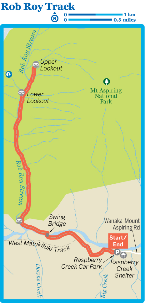
kThe Tramp
From the car park, follow a vehicle track straight up the valley on the true right (south) side of the Matukituki River, with the sharp line of Cascade Saddle visible straight ahead. The trail is wide and well formed as it passes through open farmland. In 15 to 20 minutes you’ll come to a swing bridge, where you leave the Matukituki Valley trail, crossing the river and continuing upstream through beech forest on the opposite bank.
In a few minutes the track emerges from the forest again, where there’s a seat with a perfect view up the Matukituki Valley. Here the track turns away from the valley, heading up into beech forest beside Rob Roy Stream. The stream quickly turns into a gorge, and there are early glimpses through the crack of the gorge to a stunning glaciated mountainscape ahead – it’s a preview of things to come.
The track follows the line of the boulder-choked gorge, staying high on its bank. The beech forest gets mossier and more primeval as you ascend, with the stream below occasionally slowing into deeper, bluer pools.
One hour from the swing bridge, the track comes to a break in the forest that forms the lower lookout, unveiling a dramatic scene. A pair of waterfalls pour down from high above, and glaciers are scraped across the mountains like icing. On the opposite bank, the beech forest is strung with lichen.
Continue climbing along the bank through beech forest. At a large bend in the stream, the track turns up a tributary (beside a toilet), soon popping out from the bushline and into a maze of boulders. Among the boulders is the upper lookout (30 minutes from the lower lookout), with a series of interpretive signs sitting immediately below Rob Roy Peak and, most noticeably, Rob Roy Glacier, hanging precariously from its slopes. The waterfalls you spied from the lower lookout now sit almost directly across the stream, tumbling nearly 300m over the cliffs.
Mountains wrap right around the lookout, and it’s well worth taking some time to simply hang about here for a while – it’s quite likely that you’ll get to witness bits of the glacier breaking away and avalanching down the mountain.
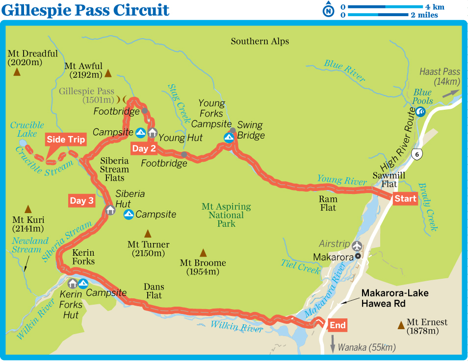
Gillespie Pass Circuit
Duration 3 days
Distance 58km (36 miles)
Difficulty Moderate to demanding
Start/End Makarora
Gateway Wanaka
Transport Bus, jetboat, helicopter
Summary This semi-circuit passes through scenic beech-forested valleys and is crowned by a superb view from an alpine pass at 1600m.
Located in the northern reaches of Mt Aspiring National Park, this popular tramp offers outstanding mountain scenery – some would say it rivals both the Matukituki and Glenorchy area tramps.
There is plenty to see and enjoy along this route, including valleys filled with silver beech (tawhai), and alpine tussock fields alive with grasshoppers, black butterflies, buttercups and mountain daisies. The bird life you might encounter includes the fantail, tomtit and rifleman, as well as the mohua (yellowhead) and the parakeet known as the kakariki.
The tramp, which should only be undertaken by experienced parties, is described here from the Young Valley to the Wilkin Valley, the easiest way to cross Gillespie Pass. This also makes for a thrilling finish if you choose, as many do, to eschew the final four to five hours’ walking in favour of a jetboat ride.
It is recommended that you carry a tent, as huts are often overcrowded in summer.
8Planning
WHEN TO TRAMP
The track should be avoided in winter and spring as part of the route is snow-covered and/or exposed to avalanches. Summer is the best (and therefore busiest) time to walk the track.
MAPS & BROCHURES
NZTopo50 BZ12 (Makarora) and NewTopo’s 1:40,000 Wilkin Valley map both cover the circuit. DOC’s Gillespie Pass, Wilkin valley tracks brochure includes descriptions of the trail and an elevation profile.
HUTS & CAMPING
All three huts along the circuit are Serviced huts ($15) and have mattresses and multifuel burners for heating. Siberia Hut may need to be booked in advance in summer – check with the Tititea/Mt Aspiring National Park Visitor Centre. Otherwise, huts don’t need to be booked.
Camping is permitted, but as this is a high-rainfall area you should choose your site with care. A $5 fee is payable if you use hut facilities.
INFORMATION
The DOC Makarora Visitor Centre, just north of the Makarora Tourist Centre, is now unstaffed and only offers display information. In Wanaka, the larger Tititea/Mt Aspiring National Park Visitor Centre, in an A-framed building on the edge of the town centre, provides all the usual information and services as well as museum-style displays on local geology, flora and fauna.
GUIDED TRAMPS
Wild Walks offers a four-day Gillespie Pass Circuit walk (from $1715) that ends with a jetboat ride back to Makarora.
8Getting There & Away
InterCity (![]() %03-442 4922; www.intercity.co.nz) has daily coaches to Makarora from Queenstown, Cromwell, Wanaka, Lake Hawea and Franz Josef. From the Makarora Tourist Centre, where they stop, it’s about a 3km walk along SH6 to the mouth of the Young River. At the tramp’s end, the mouth of the Wilkin is around 6km south of the tourist centre. If you need to spend a night in Makarora before setting out, the Makarora Tourist Centre (
%03-442 4922; www.intercity.co.nz) has daily coaches to Makarora from Queenstown, Cromwell, Wanaka, Lake Hawea and Franz Josef. From the Makarora Tourist Centre, where they stop, it’s about a 3km walk along SH6 to the mouth of the Young River. At the tramp’s end, the mouth of the Wilkin is around 6km south of the tourist centre. If you need to spend a night in Makarora before setting out, the Makarora Tourist Centre (![]() %03-443 8372; www.makarora.co.nz; 5944 Haast Pass-Makarora Rd/SH6;
%03-443 8372; www.makarora.co.nz; 5944 Haast Pass-Makarora Rd/SH6; ![]() hsummer 8am-late, winter 9am-5.30pm;
hsummer 8am-late, winter 9am-5.30pm; ![]() W) is a large all-in-one complex incorporating a cafe, bar, shop, information centre, campsite (unpowered/powered sites $15/17), dorms ($30), cabins with kitchenettes ($85) and self-contained chalets (from $128).
W) is a large all-in-one complex incorporating a cafe, bar, shop, information centre, campsite (unpowered/powered sites $15/17), dorms ($30), cabins with kitchenettes ($85) and self-contained chalets (from $128).
Wilkin River Jets (![]() %03-443 8351; www.wilkinriverjets.co.nz; Haast Pass-Makarora Rd/SH6; adult/child $120/69) offers jetboat transport on the Wilkin River. Many trampers choose this option as an exciting way to finish the tramp, and it can also be useful if you are short on time or if the river is swollen – the ford of the Makarora River near its confluence with the Wilkin is challenging enough at any time. The jetboat picks up from Kerin Forks and travels back to Makarora ($110). The jetboat can also drop trampers at the mouth of the Young River ($25, minimum three people). IThe company can also provide helicopter transfers to/from the likes of Young Forks and Kerin Forks. Its office is beside the Makarora Tourist Centre.
%03-443 8351; www.wilkinriverjets.co.nz; Haast Pass-Makarora Rd/SH6; adult/child $120/69) offers jetboat transport on the Wilkin River. Many trampers choose this option as an exciting way to finish the tramp, and it can also be useful if you are short on time or if the river is swollen – the ford of the Makarora River near its confluence with the Wilkin is challenging enough at any time. The jetboat picks up from Kerin Forks and travels back to Makarora ($110). The jetboat can also drop trampers at the mouth of the Young River ($25, minimum three people). IThe company can also provide helicopter transfers to/from the likes of Young Forks and Kerin Forks. Its office is beside the Makarora Tourist Centre.
kThe Tramp
Day 1: Makarora to Young Hut
6–7 HOURS / 20KM
The Makarora River is generally forded at Sawmill Flat, about 3km north of Makarora village, on SH6. Study the Makarora carefully then choose the best ford between its confluence with Young River and Brady Creek. The crossing here is within the ability of most trampers when the water level is normal. A high-river option is available 5km to the north by taking the short (and very beautiful) Blue Pools Walk then following the link track along the bank of the Makarora River to the mouth of the Young River. It adds about 7km and two to three hours to the day.
Once on the true right (west) side of the Makarora, you round the corner into the Young Valley, where you will find a good track leading up the true left (north) bank of the Young River.
The track remains close to the river. Within three or four hours you enter the flats below the junction of the North and South Branches of Young River. Continue to just above the confluence, where a swing bridge allows you to safely cross the North Branch. A track here also leads up the North Branch to the Young Forks Campsite, 200m from the confluence.
On the other side of the bridge a track crosses a small grassy flat and then enters the bush to continue on the true left (north) side of the South Branch. Ten minutes from the bridge the track crosses a large, unstable slip – it is well marked with rock cairns, but exercise caution and remain at the same height above the river while crossing it. You then re-enter the bush and climb steeply for 100m before sidling a series of unstable slips, reaching a bridge over Stag Creek two to three hours after crossing the North Branch.
From here the track makes a steady climb to the bushline, reaching it within two hours of the bridge. The original Young Hut was another 1km up the valley, but in 2006 a new and larger Young Hut (20 bunks) was built within the bush to protect it from the avalanches that often occur here during winter.
Day 2: Young Hut to Siberia Hut
6–8 HOURS / 12KM / 520M ASCENT, 860M DESCENT
Leave the bush and continue up the valley, using a bridge to cross to the true right (south) side of the South Branch within 1km of Young Hut. Stay on this side of the river for the next 30 minutes, enjoying views of Mt Awful (2192m) framed by the valley walls, before reaching the start of the track to Gillespie Pass on your left. A large rock cairn and signs mark the start of the route, up a northeasterly facing slope of scrub and tussock. Make sure you fill your water bottles, as this is the last place for water until well over the pass.
It’s a steep climb of 400m up the slope, alongside a rock bluff and then along the crest of a spur, where orange snow poles mark most of the route through snow grass. Just before reaching the pass, the route swings left up a small gully and climbs to a height of 1600m. It takes three to four hours to reach this point, and for many trampers the alpine setting is a good spot for an extended break or lunch, with Mt Alba (2360m) dominating the skyline.
You leave the pass by following the orange snow poles southeast along a ridge for 1km, until the route swings southwest. At times you are wandering down through snow-grass basins, which are very slippery when wet, so exercise caution. The track enters the forest on a small prominent spur and leads down to Gillespie Stream, a good spot for a rest. You continue down through forest, sidling above Gillespie Stream on its true left (south) bank, before descending steeply along a series of switchbacks to Siberia Stream and the track up to Crucible Lake.
Continue southeast beside Siberia Stream. The walk through Siberia Stream Flats is easy and the mountain scenery is spectacular. It takes about one hour to cross the grassy flats to Siberia Hut (20 bunks), on the true left (east) side of Siberia Stream. Plan on three to 3½ hours to reach the hut from the top of the pass. This part of the track has been marked with poles to keep trampers to a set path and minimise damage to the vegetation.
Side Trip: Crucible Lake
6–8 HOURS / 14KM RETURN / 530M ASCENT & DESCENT
There’s no better reason to spend an extra night at Siberia Hut than to take a day tramp up to Crucible Lake, a true alpine lake nestled beneath Mt Alba. It takes three to four hours to get there from the hut, and about the same to return. To reach the lake, backtrack through Siberia Stream Flats to Crucible Stream, where a track enters the forest on the true left (north) side of the stream. The track climbs steeply up a narrow spur to a hanging valley filled with boulders and snow grass (be sure to turn around and admire the framed views of Siberia Valley and ranges beyond), before climbing a rock moraine to the spectacular shore of Crucible Lake.
Day 3: Siberia Hut to Makarora
7–8 HOURS / 26KM
Head for about 30 minutes to the southern end of Siberia Stream Flats to reach a marked track that enters the forest. The track remains on the true left (east) bank of Siberia Stream and gradually descends away from the flats through bush. It sidles around a shoulder then follows a series of switchbacks over the final 450m to Wilkin River, a short distance upstream from Kerin Forks.
Kerin Forks Hut (10 bunks) is on grassy flats 400m downstream from the confluence of Siberia Stream and Wilkin River, on the true right (south) bank of the Wilkin; the river must be crossed to reach it. From Siberia Hut it takes two to three hours to reach the Wilkin River, where many trampers will have arranged to be picked up by jetboat.
To continue down the river, follow the marked track along the true left (north) bank. The walk is easy and within four to five hours you come to the confluence with the Makarora River. Caution has to be used when fording this river, which is normally best done upstream (north) from its junction with the Wilkin. This is a challenging river crossing that should only be attempted by experienced parties in good weather. Do not try to cross after heavy rain or any time the river is running high.
QUEENSTOWN & WANAKA
Queenstown is where New Zealand’s adventurous heart beats fastest, a place where you can throw yourself from bridges, planes or mountain tops, and skim through river canyons in jetboats or atop river boards. The town oozes adrenaline but, together with sister lake town Wanaka, it also provides a host of good mountain tramping at the edge of Mt Aspiring National Park.
Ben Lomond
Duration 6–8 hours
Distance 15.5km (9.6 miles)
Difficulty Moderate
Start/End Skyline Gondola base station
Gateway Queenstown
Transport Gondola
Summary Climb high above Queenstown on a popular ridge-top hike with ever-widening views over Lake Wakatipu, Queenstown and finally Mt Aspiring.
If you stand in Queenstown, it might be the Remarkables that dominate the scene, but if you’re on the opposite shore, looking across the lake towards Queenstown, it is the pyramidal figure of Ben Lomond, standing tall directly behind the town, that crowns the view. For hikers it’s the peak that also dominates thoughts of Queenstown.
Most of the tramp is above the bushline, providing superb views of Ben Lomond itself and the Remarkables rising like the spine of a sea monster from Lake Wakatipu.
For such an imposing-looking mountain, Ben Lomond provides a surprisingly straightforward climb, complicated only by weather and the endurance of your own legs – from Queenstown it’s a climb of around 1400m to the summit. If time or energy is short you can ride the gondola to the top station, cutting out 2.5km of the approach walk and 400m of climbing.
Note that things steepen and the terrain gets more tricky beyond Ben Lomond Saddle, so if you’re feeling the pinch at the saddle, or you struggle with heights, it’s a good turnaround point that still affords terrific views. DOC recommends that children under 10 years of age don’t climb past the saddle.
8Planning
WHEN TO TRAMP
The best time on the mountain is around November to April when the summit is likely to be free of snow. Between April and November there’s the possibility of snow and ice on the mountain, so be sure to check at the DOC visitors centre in Queenstown if you’re planning to climb during that time.
If it’s windy by the shores of Lake Wakatipu, you can expect it to be even more blowy on the summit, so assess the conditions carefully.
WHAT TO BRING
Beyond the top gondola station, the trail does not pass any streams or other water sources, so carry all the drinking water you need.
MAPS
The Ben Lomond Track is covered by the NZTopo50 CC11 (Queenstown) map.
INFORMATION
Ben Lomond is the big-ticket walk in town, so Queenstown’s DOC Visitor Centre is flush with information about the track and weather conditions. You can also pick up maps here.
8Getting There & Away
One of the great joys of this tramp is its accessibility, with the Tiki Trail beginning directly beside the base station for the Skyline Gondola (![]() %03-441 0101; www.skyline.co.nz; Brecon St; adult/child return $35/22;
%03-441 0101; www.skyline.co.nz; Brecon St; adult/child return $35/22; ![]() h9am-9pm), around a 400m walk north of Queenstown’s centre. The gondola offers the temptation of shortening the tramp, either taking out the steep climb on the Tiki Trail or floating you back down into town after a tiring day out…or both.
h9am-9pm), around a 400m walk north of Queenstown’s centre. The gondola offers the temptation of shortening the tramp, either taking out the steep climb on the Tiki Trail or floating you back down into town after a tiring day out…or both.
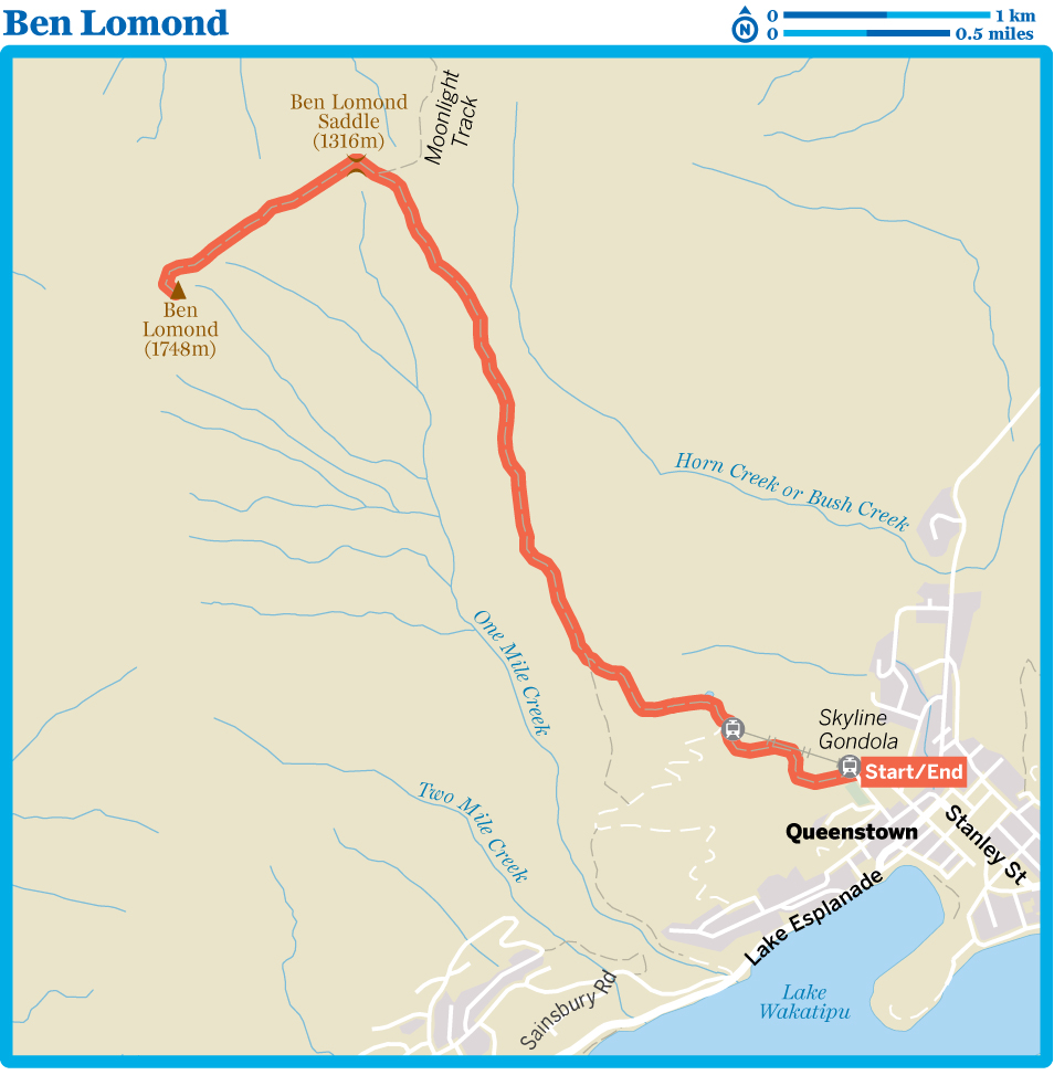
kThe Tramp
The ascent to Ben Lomond begins on the Tiki Trail, which sets out from beside the base station for the Skyline Gondola, heading up beside a mountain-bike trail. Cross the bike trail after about 100m, from where the Tiki Trail coils steeply and tightly up the slopes through Douglas fir forest, passing platforms for the Ziptrek zip-line tours through the forest.
Across the Skyline vehicle track, the Tiki Trail enters mountain beech forest and the gradient eases slightly as the track cuts across the slopes. At the next point that you meet the vehicle track you cross swords again with the mountain-bike trail. Bikes go straight across; you continue walking along the vehicle track. Stay on the vehicle track at the next bike-trail crossing, back now in Douglas fir forest as you continue to intersect with the mountain-bike park and the Ziptrek lines – it’s a window into Queenstown’s massive adventure industry. Past the Ziptrek office, you’ll emerge into a clearing, one hour from the base station, and arrive at the gondola’s top station.
Pass through the station complex (take a moment to enjoy the scene from the viewing deck) to the Market Kitchen corner, where the Ben Lomond Track sets out beside the luge chairlift. The blue Ben Lomond Track signs will guide you out of the hubbub of people and the luge, and back into dark Douglas fir forest. Within 10 minutes the track emerges from the forest to a view of Ben Lomond straight ahead.
Traverse beneath the ridge line, passing through a strip of beech forest before skirting the next, larger stand of beech, filling a deep gully, to rise to a saddle (1049m) in the ridge through tussocks and low subalpine scrub. From here the track simply follows the ridge line, keeping left at the Moonlight Track junction and rising to Ben Lomond Saddle, about 1½ hours from the top gondola station. Here you’re greeted by an array of distant peaks, with a seat on which to sit and ponder the rest of the climb.
The track now steepens as it rises up the neck of the mountain, typically following the line of the ridge or just to its northern side. It continues to steepen as it rises, winding through bouldery schist and onto the summit, reached around one hour from the saddle. The summit has an unbroken view over one of the most spectacular mountain regions in the country, including the Remarkables and a distant Tititea/Mt Aspiring.
Return to Queenstown the same way. And if fatigue has set in, there’s always the gondola…
Roys Peak
Duration 5–6 hours
Distance 16km (9.9 miles)
Difficulty Moderate
Start/End Wanaka–Mt Aspiring Rd
Gateway Wanaka
Transport Shuttle bus
Summary A long climb to a long view, this tramp ascends to the summit of a 1578m peak along the rim of Lake Wanaka, passing one of the country’s most popular mountain photo stops along the way.
If you’ve seen any one photo of Lake Wanaka (other than of that tree), it’s likely to have been taken from the Roys Peak Track, which provides one of the most photogenic vantage points in NZ. In the kindest of descriptions, the climb to Roys Peak is a grind, ascending 1220m from near the lakeshore to the antenna-tipped summit, but oh, those views…it’s truly a spectacular tramp.
Those very views have made this an extremely popular track, though many hikers aspire only to reach the ridge, about three-quarters of the way up, from where the famous ‘selfie with Lake Wanaka’ moment bombards Instagram.
8Planning
WHEN TO TRAMP
Roys Peak Track crosses private farmland and closes for lambing from the start of October to 10 November each year. Winter typically brings snow over the mountain and the risk of avalanches, making the ideal time for this tramp around mid-November to April.
MAPS
For the best perspective, pick up NZTopo50 maps CA12 (Minaret Bay) and CB12 (Cardrona).
INFORMATION
In an A-framed building on the edge of Wanaka’s town centre, the Tititea/Mt Aspiring National Park Visitor Centre offers advice on all tracks and conditions in the area. It also has a small display on the area’s natural history.
8Getting There & Away
The trailhead is around 6km from Wanaka, on the road to Mt Aspiring National Park along the western shore of Roys Bay on Lake Wanaka. A new and larger car park was constructed at the trailhead in late 2017, but in summer it’s still wise to walk or cycle from town along the lakeside Glendhu Bay Track as the car park gets pretty choked. A link trail between the Glendhu Bay Track and the Roys Peak car park was being constructed at the time of research.
Ritchies runs a shuttle-bus service from Wanaka to Mt Aspiring National Park that makes a stop at the Roys Peak trailhead (one way/return $15/20). The bus departs from the log cabin on Wanaka’s lakeshore at 8.45am and 1.30pm.

kThe Tramp
From the car park the Rob Roy Track begins as it intends to continue – climbing. Get used to that sting in your legs because it’ll be steeply up most of the way, at first through wide switchbacks.
About 30 minutes from the trailhead, the track crosses a fence on a stile as the switchbacks continue. The cars in the car park will already look like toys below. Some 10 to 15 minutes on, as the switchbacks uncoil, you’ll come to three graves beside a pine tree, including one of Willis Scaife (1887–1965), the one-time owner of Glendhu Station. There are a couple of picnic tables here also, so take a break and lap up the view of Lake Wanaka.
The gradient eases now as the track contours across the slopes for the next 20 minutes before the climb ramps up again, switchbacking through tussocky farmland, with Roys Peak now in view above you (if you’ve picked the right day). One to 1½ hours from the graves, you’ll cross a stile and enter the Stack Conservation Area.
After another lengthy traverse, the track rises to the crest of the ridge (45 minutes from the stile). Just below the track to the right is the knoll lookout where all those Roys Peak photos are snapped. The track turns up to the left from here, zigzagging up once again before crossing to the back of the ridge. After one final switchback the track follows the summit ridge to the antenna-topped tip of Roys Peak, around 30 to 45 minutes from the knoll lookout. If you’ve come on a good day, the view is stunning – down onto Lake Wanaka and across to Tititea/Mt Aspiring.
The Skyline Track continues along the ridge from here, but it’s a challenging and long route that ends on Cardrona Rd, far from where you started, so follow your ascent route back down to the car park.
Diamond Lake & Rocky Mountain
Duration 2½–3 hours
Distance 7km (4.3 miles)
Difficulty Easy to moderate
Start/End Diamond Lake car park
Gateway Wanaka
Transport Shuttle bus
Summary A low-level hill climb past a beautiful lake to views over Lake Wanaka, the mouth of the Matukituki River and a distant Tititea/Mt Aspiring.
As the hiking crowds sweat it out on the track to Roys Peak, there are wizened old trampers in Wanaka who’ll secretly tell you that those people have missed Wanaka’s best hike. Sitting across Glendhu Bay from Roys Peak, the trails around Diamond Lake and Rocky Mountain are less trafficked but no less spectacular than their big-name neighbour, while also sitting at a lower elevation, with far less ascent – around 450m compared to 1220m.
The tramp detailed here is effectively three conjoined loops taking in the bulk of the trail network on the mountain. Though we’ve outlined the tramp in an overall anticlockwise direction, you can take any of the loops in either direction. If there’s any distinction, heading to the Lake Wanaka view point first, as described here, provides the most gentle ascent.
History
Though Waitaha and Kai Tahu people occupied the area around Wanaka, there was no Māori presence when the first Europeans arrived here in 1853. The large Wanaka Station was established in 1859, and later divided into smaller runs, including Glendhu Station, which incorporated Rocky Mountain and Diamond Lake, in 1897.
Recreational use of the area began with the Wanaka Winter Sports Club, which used the frozen Diamond Lake for ice skating from the 1950s. In the 1990s a local man, Stuart Landsborough, came up with an idea to carve a walking track to the summit of Rocky Mountain, which he constructed with the support of the Glendhu Station landowners. For 13 years Landsborough maintained the trail himself, until the 106-hectare Diamond Lake Conservation Area was created in 2005.
Environment
The landscape you see at Rocky Mountain, including the hollow that holds Diamond Lake, was shaped by ice-age glaciers. A staircase of cliffs and bluffs shields pockets of native forest with New Zealand broadleaf (kapuka), wineberry (makomako), kohuhu and a few black pines (matai). The reeds that ring Diamond Lake are raupo. Bird life in the patches of forest includes the fantail (piwakawaka), bellbird (korimako) and grey warbler (riroriro). You may also see the New Zealand falcon (karearea) overhead, as the bird is known to nest nearby.
8Planning
WHEN TO TRAMP
Parts of the lower sections of the trail are shaded by bluffs and are prone to ice cover in winter, so avoid walking then. The track is a good option for the rest of the year and, unlike Roys Peak, doesn’t close for lambing, making it a good springtime alternative when Roys is off limits.
MAPS
The NZTopo50 CA12 (Minaret Bay) map covers the tramp.
INFORMATION
Pay a visit to the Tititea/Mt Aspiring National Park Visitor Centre, at the eastern edge of Wanaka’s town centre, for any additional information on the Diamond Lake Conservation Area and track conditions.
8Getting There & Away
The large car park at the start of the tramp is on the Wanaka–Mt Aspiring Rd, 18km from Wanaka. The road is sealed all the way.
Ritchies runs a shuttle-bus service from Wanaka to Mt Aspiring National Park that makes a stop at the Diamond Lake car park (one way/return $15/20). The bus departs from the log cabin on Wanaka’s lakeshore at 8.45am and 1.30pm.

kThe Tramp
Cross the stile at the end of the car park and enter the Diamond Lake Conservation Area. The 4WD track climbs quickly to a plateau that’s seemingly steamrolled flat into the mountain, crossing it to a track junction just past a large willow tree. Veer left to arrive at the willow-ringed shores of Diamond Lake, which you round clockwise. As you arrive beneath the cliffs, you’ll come to another track junction. Continue straight ahead, signed to Rocky Mountain, rising to the base of the cliffs and then up a long flight of steps to a wooden lookout platform (30 minutes from the car park) directly above Diamond Lake, which now looks like a sinkhole below. Beyond the lake to the right, across the valley, you’ll see Twin Falls, deeply gouged into the lower slopes of Treble Cone. The slope of exposed rock seen directly ahead over the lake is Hospital Flat, Wanaka’s prime rock-climbing site.
The track continues to climb. At the next junction, a couple of minutes past the lookout, keep right, following the path signed to Lake Wanaka Viewpoint. In another 10 to 15 minutes, detour right, heading out to the Lake Wanaka Viewpoint, where a seat at the mountain’s edge stares out over the lake to Albert Town and across Glendhu Bay to Roys Peak.
Return to the main track and turn right. Within 100m the track swings left, zigzagging steeply up the slopes, crossing a gully and then climbing just as steeply on a more rugged section of track. The going quickly flattens out as you reach another high plateau. In a few steps, turn right onto the ‘eastern track’, climbing through the final rack of bluffs towards the summit. There are fine views of Lake Wanaka and the mouth of the Matukituki River as the trail creeps along the mountain’s edge, but the grandstand view comes at the summit (1½ hours from the car park), as the scene peels open to reveal a cavalcade of features: Lake Wanaka, Treble Cone, Twin Falls and ahead, through the Matukituki Valley, the serrated summit of Tititea/Mt Aspiring.
Instead of returning on the same track, continue ahead onto the ‘western track’, which is marked on the summit by an orange pole. This track descends gently off the summit, rounds a couple of notches in the cliffs and then curls down to the high plateau. At the junction here, turn right (signed as ‘western track’), heading to the western edge of the mountain, where you’ll get an eyeball-to-eyeball view of Twin Falls.
The track descends through a damp gully – notice the sudden change in the vegetation – cutting at times beneath overhanging cliffs. A steep set of tight switchbacks delivers you back to the track junction just above the Diamond Lake lookout platform. Turn right, passing the lookout, and return to the lakeshore. Unless you’re in a screaming hurry, turn left here, completing the lake loop before returning to the car park.
TOWNS & FACILITIES
Queenstown
![]() %03 / POP 12,500
%03 / POP 12,500
Queenstown is as much a verb as a noun, a place of doing that likes to spruik itself as the ‘adventure capital of the world’. It’s famously the birthplace of bungy jumping, and the list of adventures you can throw yourself into here is encyclopedic – alpine heliskiing to zip lining. It’s rare that a visitor leaves without having tried something that ups their heart rate, but to pigeonhole Queenstown as just a playground is to overlook its cosmopolitan dining and arts scene, its fine vineyards, and the diverse range of bars that can make evenings as fun-filled as the days.
Expect big crowds, especially in summer and winter, but also big experiences.
4Sleeping & Eating
Choice abounds, but be sure to book your accommodation in advance from December to February, or when the ski season’s in full flight from June to September.
![]() oYHA Queenstown LakefrontHOSTEL$
oYHA Queenstown LakefrontHOSTEL$
(![]() %03-442 8413; www.yha.co.nz; 88-90 Lake Esplanade; dm/s/d without bathroom from $30/80/102;
%03-442 8413; www.yha.co.nz; 88-90 Lake Esplanade; dm/s/d without bathroom from $30/80/102; ![]() p
p![]() W)
W) ![]() S
S
This large lakefront hostel, fresh from a refit in 2017, has basic but neat-as-a-pin bunkrooms and an industrial-sized kitchen with window benches to absorb the view. The TV room is filled with beanbags and there are even a couple of massage chairs in the lounge. Lakeview suites get a shared balcony (and some traffic noise).
![]() oLittle Paradise LodgeLODGE$$
oLittle Paradise LodgeLODGE$$
(![]() %03-442 6196; www.littleparadise.co.nz; Glenorchy–Queenstown Rd, Mt Creighton; s/d $90/140, units $180;
%03-442 6196; www.littleparadise.co.nz; Glenorchy–Queenstown Rd, Mt Creighton; s/d $90/140, units $180; ![]() p)
p)
This isolated and peaceful lodge, almost midway between Queenstown and Glenorchy, is a whimsical gem. From the toilet-cistern aquariums (complete with fish) to the huge garden with 3000 roses, monkey puzzle trees and the Swiss owner’s own sculptural work, you won’t have seen a place like it. There are two rooms in the main house and a unit out the back.
If you’re not staying, you can still wander the gardens ($15), which straddle the 45th parallel.
Creeksyde Queenstown Holiday Park & MotelsHOLIDAY PARK$$
(![]() %03-442 9447; www.camp.co.nz; 54 Robins Rd; sites from $55, d without bathroom from $83, units from $139;
%03-442 9447; www.camp.co.nz; 54 Robins Rd; sites from $55, d without bathroom from $83, units from $139; ![]() p
p![]() W)
W) ![]() S
S
In a garden setting, this pretty and extremely well-kept holiday park has accommodation ranging from small tent sites along the creek to fully self-contained motel units. It claims to be the ‘world’s first environmentally certified holiday park’ and a number of the powered sites were switched to solar power in 2017.
There are quirky sculptures throughout and an ablutions block disguised as a medieval oast house (hop kiln).
![]() oHidden LodgeB&B$$$
oHidden LodgeB&B$$$
(![]() %03-442 6636; www.hiddenlodgequeenstown.co.nz; 28 Evergreen Pl, Sunshine Bay; r from $395;
%03-442 6636; www.hiddenlodgequeenstown.co.nz; 28 Evergreen Pl, Sunshine Bay; r from $395; ![]() p
p![]() i
i![]() W)
W)
The well-named Hidden Lodge is literally the last place west in Queenstown. Tucked away in Sunshine Bay, it has enormous rooms, unfettered lake and mountain views, complimentary beer and wine, and a new outdoor hot tub. A quiet escape that is indeed a hidden gem.
![]() oPublic Kitchen & BarMODERN NZ$$
oPublic Kitchen & BarMODERN NZ$$
(![]() %03-442 5969; www.publickitchen.co.nz; Steamer Wharf, Beach St; dishes $12-46;
%03-442 5969; www.publickitchen.co.nz; Steamer Wharf, Beach St; dishes $12-46; ![]() h11am-late;
h11am-late; ![]() W)
W)
You can’t eat closer to the water than at this excellent lakefront eatery where local is law: Cardrona lamb, Fiordland wild venison, Geraldine pork, South Island fish. Grab a group and order a selection of plates of varying sizes from the menu. The meaty dishes, in particular, are excellent.
Bespoke KitchenCAFE$$
(![]() %03-409 0552; www.bespokekitchen.co.nz; 9 Isle St; mains $11-19;
%03-409 0552; www.bespokekitchen.co.nz; 9 Isle St; mains $11-19; ![]() h8am-5pm;
h8am-5pm; ![]() W)
W)
Occupying a light-filled corner site near the gondola, Bespoke delivers everything you’d expect of a smart Kiwi cafe. It has a good selection of counter food, beautifully presented cooked options, a range of outside seating in sight of the mountains and, of course, great coffee. In 2015, within six months of opening, it was named NZ’s cafe of the year.
Blue KanuMODERN NZ$$
(![]() %03-442 6060; www.bluekanu.co.nz; 16 Church St; mains $28-38;
%03-442 6060; www.bluekanu.co.nz; 16 Church St; mains $28-38; ![]() h4pm-late)
h4pm-late)
Disproving the rule that all tiki houses are inherently tacky, Blue Kanu serves up a food style it calls ‘Polynasian’ – bibimbap in one hand, fried chicken pineapple buns in the other. It’s relaxed and personable, capable of making you feel like a regular in minutes. The marriage of the Polynesian decor and the chopsticks sounds impossible to pull off, but it works.
FergburgerBURGERS$$
(![]() %03-441 1232; www.fergburger.com; 42 Shotover St; burgers $12-19;
%03-441 1232; www.fergburger.com; 42 Shotover St; burgers $12-19; ![]() h8am-5am)
h8am-5am)
Who knew a burger joint could ever be a destination restaurant? Such are the queues at Fergburger that it often looks like an All Blacks scrum out the front. The burgers are as tasty and satisfying as ever, but the wait can be horrendous and the menu has more choices than the place has seats.
7Supplies & Equipment
Small Planet OutdoorsSPORTS & OUTDOORS
(![]() %03-442 5397; www.smallplanetsports.com; 15-17 Shotover St;
%03-442 5397; www.smallplanetsports.com; 15-17 Shotover St; ![]() h9am-7pm Oct-May, 8am-9pm Jun-Sep)
h9am-7pm Oct-May, 8am-9pm Jun-Sep)
This warren-like store is something of a bazaar of outdoors gear, with everything you might need for backcountry skiing, climbing, snowboarding or tramping.
Outside SportsMOUNTAIN BIKING
(![]() %03-441 0074; www.outsidesports.co.nz; 9 Shotover St;
%03-441 0074; www.outsidesports.co.nz; 9 Shotover St; ![]() h8.30am-8pm)
h8.30am-8pm)
Has a good range of mountain bikes (from $39/59 per half/full day) and ski equipment ($25 to $59 per day) for hire, as well as outdoor gear for sale.
Alpine SupermarketSUPERMARKET$
(![]() %03-442 8961; cnr Shotover & Stanley Sts;
%03-442 8961; cnr Shotover & Stanley Sts; ![]() h7am-10pm Mon-Sat, 9am-10pm Sun)
h7am-10pm Mon-Sat, 9am-10pm Sun)
Central supermarket if you’re self-catering or stocking up for a tramp.
8Information
Queenstown i-SITE (![]() %03-442 4100; www.queenstownisite.co.nz; cnr Shotover & Camp Sts;
%03-442 4100; www.queenstownisite.co.nz; cnr Shotover & Camp Sts; ![]() h8.30am-8pm) Friendly and informative despite being perpetually frantic, the saintly staff here can help with bookings and information on Queenstown, Gibbston, Arrowtown and Glenorchy.
h8.30am-8pm) Friendly and informative despite being perpetually frantic, the saintly staff here can help with bookings and information on Queenstown, Gibbston, Arrowtown and Glenorchy.
8Getting There & Away
Air New Zealand (![]() %0800 737 000; www.airnewzealand.co.nz) flies direct to Queenstown from Auckland, Wellington and Christchurch. Jetstar (
%0800 737 000; www.airnewzealand.co.nz) flies direct to Queenstown from Auckland, Wellington and Christchurch. Jetstar (![]() %0800 800 995; www.jetstar.com) also flies the Auckland route.
%0800 800 995; www.jetstar.com) also flies the Auckland route.
Various airlines offer direct flights to Queenstown from Sydney, Melbourne, Brisbane and the Gold Coast in Australia.
Most buses and shuttles stop on Athol St or opposite the i-SITE; check when you book.
Atomic Travel (![]() %03-349 0697; www.atomictravel.co.nz) Daily (except Tuesday) bus to and from Twizel ($30, 3¼ hours), Tekapo ($45, four hours) and Christchurch ($55, 7¼ hours).
%03-349 0697; www.atomictravel.co.nz) Daily (except Tuesday) bus to and from Twizel ($30, 3¼ hours), Tekapo ($45, four hours) and Christchurch ($55, 7¼ hours).
Catch-a-Bus South (![]() %03-479 9960; www.catchabussouth.co.nz) Door-to-door daily bus from Invercargill ($60, 3¼ hours) and Bluff ($75, 3¾ hours), heading via Gore ($61, 2½ hours) three times a week.
%03-479 9960; www.catchabussouth.co.nz) Door-to-door daily bus from Invercargill ($60, 3¼ hours) and Bluff ($75, 3¾ hours), heading via Gore ($61, 2½ hours) three times a week.
InterCity (![]() %03-442 4922; www.intercity.co.nz) Daily coaches to/from Wanaka (from $17, 1¾ hours), Franz Josef (from $62, eight hours), Dunedin (from $26, 4¼ hours), Invercargill (from $49, 2½ hours) and Christchurch (from $55, 8½ to 11½ hours).
%03-442 4922; www.intercity.co.nz) Daily coaches to/from Wanaka (from $17, 1¾ hours), Franz Josef (from $62, eight hours), Dunedin (from $26, 4¼ hours), Invercargill (from $49, 2½ hours) and Christchurch (from $55, 8½ to 11½ hours).
Naked Bus (https://nakedbus.com) Buses daily to Wanaka (from $17, 1¾ hours), Te Anau (from $10, 2½ hours), Franz Josef (from $62, eight hours) and Christchurch (from $55, 8½ hours).
Ritchies (![]() %03-443 9120; www.alpineconnexions.co.nz) Daily buses to/from Dunedin ($50, 4½ hours).
%03-443 9120; www.alpineconnexions.co.nz) Daily buses to/from Dunedin ($50, 4½ hours).
Ritchies Connectabus Wanaka (![]() %0800 405 066; www.connectabus.com;
%0800 405 066; www.connectabus.com; ![]() W) Heads to/from Wanaka five times daily ($35, two hours). Does hotel pick-ups and has free wi-fi on board.
W) Heads to/from Wanaka five times daily ($35, two hours). Does hotel pick-ups and has free wi-fi on board.
Wanaka
![]() %03 / POP 6480
%03 / POP 6480
So long described as Queenstown’s smaller and more demure sibling, Wanaka now feels grown up enough to have asserted its own dentity. What it does share with Queenstown is the fact that they’re both lake and mountain towns bristling with outdoor and adventure opportunities. Despite constant growth in both size and costs, Wanaka retains a fairly laid-back, small-town atmosphere.
4Sleeping & Eating
![]() oWanaka BakpakaHOSTEL$
oWanaka BakpakaHOSTEL$
(![]() %03-443 7837; www.wanakabakpaka.co.nz; 117 Lakeside Rd; dm $31, d with/without bathroom $92/74;
%03-443 7837; www.wanakabakpaka.co.nz; 117 Lakeside Rd; dm $31, d with/without bathroom $92/74; ![]() p
p![]() i
i![]() W)
W)
The only lakeside hostel in town delivers million-dollar views at backpacker prices. Amenities are top-shelf and it’s worth paying a bit extra for the en suite double with the gorgeous views, though you can also just lap it all up from the wide lounge windows. There are bikes for hire and the hot-water bottles come free.
YHA WanakaHOSTEL$
(![]() %03-443 1880; www.yha.co.nz; 94 Brownston St; dm $30-38, d with/without bathroom from $108/93;
%03-443 1880; www.yha.co.nz; 94 Brownston St; dm $30-38, d with/without bathroom from $108/93; ![]() i
i![]() W)
W) ![]() S
S
This stalwart is older than many of its guests, and it’s mellowed comfortably with age. It has a mix of dorms and private rooms, but best of all are the large lounge, with commanding lake and mountain views, and the quiet reading room. The giant topo map in the lounge is great for planning tramps.
Wanaka Kiwi Holiday Park & MotelsHOLIDAY PARK$
(![]() %03-443 7766; www.wanakakiwiholidaypark.nz; 263 Studholme Rd North; campsites $25-27, units with/without bathroom from $124/80;
%03-443 7766; www.wanakakiwiholidaypark.nz; 263 Studholme Rd North; campsites $25-27, units with/without bathroom from $124/80; ![]() p
p![]() W)
W)
This charming and relaxing campground is tucked under Roys Peak, with grassy terraced sites for tents and campervans, lots of trees and pretty views. Facilities include a barbecue area with heaters, and free unlimited wi-fi, plus spa pool and sauna ($5). Older-style motel units have all been renovated, and the newest budget cabins are warm and cosy with wooden floors. There’s a courtesy van for runs into (but not back from) town.
![]() oLakesideAPARTMENT$$$
oLakesideAPARTMENT$$$
(![]() %03-443 0188; www.lakesidewanaka.co.nz; 9 Lakeside Rd; apt from $295;
%03-443 0188; www.lakesidewanaka.co.nz; 9 Lakeside Rd; apt from $295; ![]() W
W![]() s)
s)
Luxuriate in a modern apartment in a prime position overlooking the lake, right by the town centre. All 23 apartments have three bedrooms, but can be rented with only one or two bedrooms open. The swimming pool is a relative rarity in these parts, and if you hire ski gear through the website it can be delivered to your door.
![]() oKai WhakapaiCAFE$$
oKai WhakapaiCAFE$$
(![]() %03-443 7795; cnr Helwick & Ardmore Sts; mains $19-26;
%03-443 7795; cnr Helwick & Ardmore Sts; mains $19-26; ![]() h7am-11pm;
h7am-11pm; ![]() c)
c)
As Wanaka as that tree, this local institution is where the town seems to congregate on a sunny evening for a liquid sundowner over excellent pizza or salad. Locally brewed craft beers are on tap and there are Central Otago wines as well.
Francesca’s Italian KitchenITALIAN$$
(![]() %03-443 5599; www.fransitalian.co.nz; 93 Ardmore St; mains $20-32;
%03-443 5599; www.fransitalian.co.nz; 93 Ardmore St; mains $20-32; ![]() hnoon-3pm & 5pm-late)
hnoon-3pm & 5pm-late)
Pretty much the matriarch of Wanaka eateries, the perennially busy and cavernous Francesca’s has the big flavours and easy conviviality of an authentic Italian family trattoria. Even simple things such as pizza, pasta and polenta chips are exceptional. It also runs a pizza food truck (![]() %0800 4647 4992; www.francescaspizzas.com; pizza $10-20;
%0800 4647 4992; www.francescaspizzas.com; pizza $10-20; ![]() h4-9pm) on Brownston St.
h4-9pm) on Brownston St.
Federal DinerCAFE$$
(![]() %03-443 5152; www.federaldiner.co.nz; 47 Helwick St; breakfast $10-19, mains $22-40;
%03-443 5152; www.federaldiner.co.nz; 47 Helwick St; breakfast $10-19, mains $22-40; ![]() h7am-4pm Mon & Tue, to 9pm Wed-Sun;
h7am-4pm Mon & Tue, to 9pm Wed-Sun; ![]() W)
W)
When it’s this hidden away and still this popular, you know to expect good things. This cosmopolitan cafe delivers robust breakfasts, excellent coffee, legendary scones, gourmet sandwiches and salads. In the evenings the menu shifts to substantial dishes such as baked gnocchi and slow-roasted lamb shoulder.
![]() oKikaTAPAS$$$
oKikaTAPAS$$$
(![]() %03-443 6535; http://kika.nz; 2 Dunmore St; plates $12-55;
%03-443 6535; http://kika.nz; 2 Dunmore St; plates $12-55; ![]() h5.30pm-late)
h5.30pm-late)
The baby sister to Francesca’s has grown up fast, vaulting within just a year of opening to become the only Wanaka eatery named among New Zealand’s top 100 restaurants in 2017. It’s a Mediterranean mix of modern Italian food, served tapas-style in a casual dining space.
7Supplies & Equipment
MT OutdoorsSPORTS & OUTDOORS
(![]() %03-443 2888; www.mtoutdoors.co.nz; 17 Dunmore St;
%03-443 2888; www.mtoutdoors.co.nz; 17 Dunmore St; ![]() h9am-6pm Sep-Jun, 8am-7pm Jul & Aug)
h9am-6pm Sep-Jun, 8am-7pm Jul & Aug)
Sells camping and tramping gear, and also sells and rents out ski equipment.
New WorldSUPERMARKET$
(![]() %03-443 0048; www.newworld.co.nz; 20 Dunmore St;
%03-443 0048; www.newworld.co.nz; 20 Dunmore St; ![]() h7am-9pm)
h7am-9pm)
Stocks everything you need to self-cater or hit the trails.
Mediterranean MarketSUPERMARKET$
(![]() %03-443 0118; 20 Ardmore St;
%03-443 0118; 20 Ardmore St; ![]() h8am-6.30pm Mon-Fri, 9am-4pm Sat & Sun)
h8am-6.30pm Mon-Fri, 9am-4pm Sat & Sun)
Grab a few of the finer things for your backpack or that picnic stash at this buono grocery store.
8Information
Wanaka i-SITE (![]() %03-443 1233; www.lakewanaka.co.nz; 103 Ardmore St;
%03-443 1233; www.lakewanaka.co.nz; 103 Ardmore St; ![]() h8am-7pm summer, to 5pm winter) Extremely helpful but always busy.
h8am-7pm summer, to 5pm winter) Extremely helpful but always busy.
8Getting There & Away
Queenstown is Wanaka’s main transport link to the outside world, but bus services do range out from here to Dunedin and up the West Coast.
InterCity (![]() %03-442 4922; www.intercity.co.nz) Coaches depart from outside the Log Cabin on the lakefront, with daily services to Queenstown (from $17, two hours), Makarora (from $12, 1½ hours) and Franz Josef (from $43, six hours).
%03-442 4922; www.intercity.co.nz) Coaches depart from outside the Log Cabin on the lakefront, with daily services to Queenstown (from $17, two hours), Makarora (from $12, 1½ hours) and Franz Josef (from $43, six hours).
Naked Bus (https://nakedbus.com) Services to Queenstown (from $17, two hours) and Franz Josef (from $43, six hours).
Ritchies (![]() %03-443 9120; www.alpinecoachlines.co.nz) Links Wanaka with Dunedin ($50, four hours), transferring to an InterCity coach at Cromwell.
%03-443 9120; www.alpinecoachlines.co.nz) Links Wanaka with Dunedin ($50, four hours), transferring to an InterCity coach at Cromwell.
Ritchies Connectabus Wanaka (![]() %0800 405 066; www.connectabus.com) Heads to/from Queenstown five times daily ($35, two hours) via Queenstown airport. Free wi-fi on board. Call ahead for a hotel pick-up.
%0800 405 066; www.connectabus.com) Heads to/from Queenstown five times daily ($35, two hours) via Queenstown airport. Free wi-fi on board. Call ahead for a hotel pick-up.
Glenorchy
![]() %03 / POP 360
%03 / POP 360
Perhaps best known as the gateway to the Routeburn Track, Glenorchy sits on a rare shelf of flat land at the head of Lake Wakatipu. The small town is a great option if you want to be beside the lake and the mountains but prefer to stay away from the bustle and bluster of Queenstown. The tramping is sensational, and the town is also a base for horse treks, jetboat rides, helicopter flights and skydives.
4Sleeping & Eating
Glenorchy MotelMOTEL$$
(![]() %0274 368 531; www.glenorchymotels.co.nz; 87 Oban St; r from $150;
%0274 368 531; www.glenorchymotels.co.nz; 87 Oban St; r from $150; ![]() W)
W)
Given the full nip and tuck by new owners in 2017, the eight rooms here have some design savvy, an outdoor hot tub has been added, and there’s a wood sauna out the back if you need to thaw some limbs after a day on the trails.
![]() oEcoScapesCABIN$$$
oEcoScapesCABIN$$$
(![]() %03-442 4900; http://ecoscapes.nz; Kinloch Rd, Kinloch; r $395;
%03-442 4900; http://ecoscapes.nz; Kinloch Rd, Kinloch; r $395; ![]() W)
W) ![]() S
S
Opened in 2017, these twin contemporary cabins are in utter contrast to the historic Kinloch Lodge next door. Built using passive design, they feature blonde woods, ultra-modern furnishings and feel almost like a city apartment plonked into the wilderness. The view from the bed across the lake is better than TV, but if you really must watch something else, the electronic blinds whirr down to become a screen for a data projector with Apple TV and Netflix.
Glenorchy Lake HouseB&B$$$
(![]() %03-442 4900; www.glenorchylakehouse.co.nz; Mull St; r $295, house from $495;
%03-442 4900; www.glenorchylakehouse.co.nz; Mull St; r $295, house from $495; ![]() W)
W) ![]() S
S
The well-named Lake House (it’s the closest place in town to the lake) is a boutique B&B attached to the excellent Trading Post cafe. The two guest bedrooms are decked out with Egyptian cotton sheets and flat-screen TVs and there’s an outdoor spa in which to soak away the rigours of a day’s tramping. Rent the whole house (sleeping up to nine people) and you get the cute attic bedroom.
Queenie’s DumplingsDUMPLINGS$
(![]() %03-442 6070; http://queeniesdumplings.wixsite.com/queeniesdumplings; 27 Mull St; 9 dumplings $13.50, noodle soup $15;
%03-442 6070; http://queeniesdumplings.wixsite.com/queeniesdumplings; 27 Mull St; 9 dumplings $13.50, noodle soup $15; ![]() h11am-4pm)
h11am-4pm)
Where else would you expect to find an authentic little dumpling joint than far-flung, rural Glenorchy? Choose from seven types of dumplings, or a handful of noodle soups.
Glenorchy CafeCAFE$$
(GYC; ![]() %03-442 9978; 25 Mull St; mains $12-20;
%03-442 9978; 25 Mull St; mains $12-20; ![]() h10am-4.30pm Sun-Fri, to 1.30am Sat)
h10am-4.30pm Sun-Fri, to 1.30am Sat)
Grab a sunny table out the back of this cute little cottage and tuck into cooked breakfasts, sandwiches and soup. Head inside on Saturday night to partake in pizza and beer underneath the oddball light fixtures.
Glenorchy HotelPUB FOOD$$
(![]() %03-409 2049; www.glenorchy-nz.co.nz; 42-50 Mull St; mains $19-32;
%03-409 2049; www.glenorchy-nz.co.nz; 42-50 Mull St; mains $19-32; ![]() h8.30am-9pm;
h8.30am-9pm; ![]() p
p![]() W)
W)
The front garden of this pub isn’t a bad spot for a beer or a filling meal. It also has basic rooms (from $130/95 with/without bathroom) in a separate wing from the bar. It offers free parking while you’re out tramping, and self-contained campervans can park up overnight.
7Supplies & Equipment
Mrs Woolly’s General StoreSUPERMARKET, CAFE$
(64 Oban St; ![]() h10am-5.30pm)
h10am-5.30pm)
Mrs Woolly’s has a small gourmet-grocery section that could fuel a few days of tramping – fresh fruit and vegetables, rice, pasta, chocolate, dehydrated hiking meals and handy ziplock bags of muesli. There’s a campground (sites $35) out the back (you can even order breakfast and coffee delivered to your tent) and bikes for hire.
8Information
Glenorchy Information Centre & Store (![]() %03-409 2049; www.glenorchy-nz.co.nz; 42-50 Mull St;
%03-409 2049; www.glenorchy-nz.co.nz; 42-50 Mull St; ![]() h8.30am-9pm) Attached to the Glenorchy Hotel, this little shop is a good source of weather and track information. Fishing rods and mountain bikes can be hired, and it sells tramping supplies, including gas canisters and a good selection of maps. It also has a bottle shop, bless it.
h8.30am-9pm) Attached to the Glenorchy Hotel, this little shop is a good source of weather and track information. Fishing rods and mountain bikes can be hired, and it sells tramping supplies, including gas canisters and a good selection of maps. It also has a bottle shop, bless it.
8Getting There & Away
Glenorchy lies at the head of Lake Wakatipu, a scenic 40-minute (46km) drive northwest from Queenstown, winding around bluffs and coves with sweeping views over the lake and its frame of mountains. There are no bus services, but there are trampers’ shuttles during the Great Walks season (late October to April). Shuttles pick up from the Glenorchy Hotel, which offers free parking to trampers.