TRAIL 13 North Bay
Sugarloaf Ridge State Park: Bald Mountain
TRAIL USE
Hike, Run
LENGTH
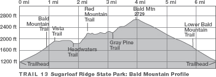
6.7 miles, 5 hours
VERTICAL FEET
±1900'
DIFFICULTY
– 1 2 3 4 5 +
TRAIL TYPE
Loop
SURFACE TYPE
Dirt, Paved
FEATURES
Fee
Mountain
Summit
Wildflowers
Birds
Great Views
Camping
FACILITIES
Restrooms
Picnic Tables
Water
Phone
This semiloop route is a challenge, but well worth the effort. A superb array of trees, shrubs, and wildflowers, along with some of the best views in the North Bay, are the rewards for tackling the 1500-foot climb to the summit of Bald Mountain. Camping is available in developed family campsites and a group camp, both near the entrance kiosk. Reservations are required March 15–Oct. 31; first-come, first-served camping is from Nov. 1–March 14. For reservations, call (800) 444-7275.
Best Time
This route is best in spring and fall.
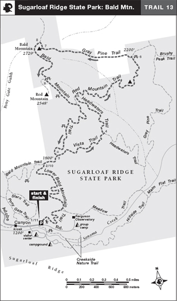
Finding the Trail
From State Hwy. 12 just north of Kenwood, take Adobe Canyon Rd. and go northeast 3.4 miles to the Sugarloaf Ridge State Park entrance kiosk. Continue 0.1 mile to a dirt parking area, left. The trailhead is on the northeast corner of the parking area. 1
1
Trail Description
The Lower Bald Mountain Trail, a single track, heads east from the parking area and wanders gently uphill through a serpentine grassland dotted with native bunchgrass, chaparral, and wildflowers, including blue-eyed grass, yarrow, bluedicks, lupine, vetch, and blow wives. At a junction with the Meadow Trail, veer left and soon begin a moderate uphill climb via a series of switchbacks in a densely wooded area. Just short of the 1-mile point, your trail merges with the Bald Mountain Trail, part of the Bay Area Ridge Trail.2 Bearing right on this paved road, you follow it steadily uphill on a moderate grade. Where the road angles sharply left, you turn right onto the single track Vista Trail.3
 Wildflowers
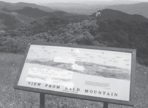
Atop Bald Mountain two display panels help you identify landmarks to the north and south.
The Vista Trail skirts a seasonal wetland, passes a fern-draped spring, and then climbs across a steep, grassy slope that affords views of Sonoma Creek and Sugarloaf Ridge, both right. A short, steep descent brings you to a junction with the Headwaters Trail.4 Bearing left, you walk in the shade of Douglas-fir and coast live oak. Reaching Sonoma Creek but staying on its west side, the trail bends left and rises on a moderate grade. After struggling uphill over rough ground, the trail at last reaches a T-junction with the Red Mountain Trail,5 a single track. Here you turn right and cross a branch of Sonoma Creek.
On a rolling course, the trail heads generally eastward to cross a larger branch of Sonoma Creek via a wooden bridge. Eventually the trail enters a side canyon and switchbacks up to a knoll. Suddenly you are atop a manzanita barren—the sandy, rocky soil is perfect for these hardy, pioneering plants. From here you have a wonderful 360-degree view that, at last, reveals your goal, the summit of Bald Mountain, slightly north of west.
 Great Views
Descending north from the knoll, you meet the Gray Pine Trail, a dirt road, at a T-junction.6 Now turning left, you ramble uphill on a moderate grade. After several steep pitches, you leave the Gray Pine Trail where it bends right, and continue west over windswept open ground a few hundred feet to the top of Bald Mountain (2729').7
On a clear day, the views from Bald Mountain are extraordinary, ranging from the Sierra Nevada to Point Reyes, and from Snow Mountain, north of Clear Lake, to San Francisco.
When it is time to head down, retrace your route to the Gray Pine Trail, turn left onto it, and follow it steeply downhill to a T-junction with the Bald Mountain Trail, a dirt road.8 Here you turn left, climb briefly, and then circle the west side of Bald Mountain to a T-junction with a paved road.9 Turning left, you head downhill on a gentle and then moderate grade into forest. After passing the junction with the Vista Trail, continue downhill on the Bald Mountain and Lower Bald Mountain trails,10 retracing your route to the parking area.11
 MILESTONES
Trail 13
1 0.0 Take Lower Bald Mountain Trail east, then north
2 0.9 Right on Bald Mountain Trail (paved)
3 1.2 Right on Vista Trail
4 1.8 Left on Headwaters Trail
5 2.3 Right on Red Mountain Trail
6 3.2 Left on Gray Pine Trail
7 3.9 Summit of Bald Mountain (2729')
8 4.0 Left at T-junction with Bald Mountain Trail (dirt)
9 4.4 Left at T-junction with Bald Mountain Trail (paved)
10 5.8 Left at junction with Lower Bald Mountain Trail
11 6.7 Back at parking area