TRAIL 16 East Bay
Tilden Regional Park: Wildcat Peak
TRAIL USE
Hike, Run, Child Friendly
LENGTH
3.3 miles, 1–2 hours
VERTICAL FEET
±900'
DIFFICULTY
– 1 2 3 4 5 +
TRAIL TYPE
Loop
SURFACE TYPE
Dirt
FEATURES
Stream
Canyon
Mountain
Summit
Birds
Great Views
FACILITIES
Visitor Center
Restrooms
Picnic Tables
Water
Phone
This scenic loop hike takes you from the Tilden Park Environmental Education Center to the summit of Wildcat Peak via the Jewel Lake, Sylvan, Peak, and Laurel Canyon trails. Terrific views of the Bay Area and a variety of plants and birds keep this route interesting throughout.
Best Time
This route is accessible all year, but trails may be very muddy in wet weather.
Finding the Trail
From Interstate 80 in Berkeley, take the University Ave. exit and go east 2.1 miles to Oxford St. Turn left and go 0.7 mile to Rose St. Turn right and go one block to Spruce St. Turn left and follow Spruce St. 1.8 miles to an intersection with Grizzly Peak Blvd. and Wildcat Canyon Rd. Cross the intersection and immediately turn left from Wildcat Canyon Dr. onto Canon Dr. There is a sign here for NATURE TRAIL, PONY RIDE, WILDCAT CANYON. Go downhill 0.3 mile to a junction with Central Park Dr. Turn left and go 0.1 mile to a large parking area.
The trailhead is behind the Environmental Education Center, which is a short walk north from the parking area on a paved path.
Trail Description
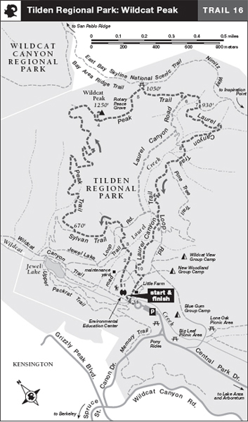
From the back deck of the Environmental Education Center 1 walk north across the lawn and get on the Jewel Lake Trail, which you follow for about 100 yards to a dirt road. Cross it and walk about 50 yards on a wide dirt path to a trail post and a junction. Both the Jewel Lake and Sylvan trails are left; the Laurel Canyon and Pine Tree trails are right.

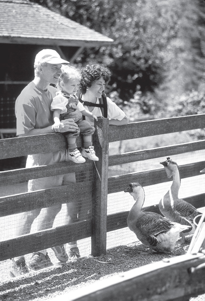
Kids and geese meet at the Environmental Education Center in Tilden Regional Park, the starting point for the hike up Wildcat Peak.
 OPTIONS
Wet-Weather Descent
The Laurel Canyon Trail may be difficult in wet weather. A more-sure-footed alternative from the intersection of the Peak Trail and Laurel Canyon Rd. 6 is to turn right and descend Laurel Canyon Rd. to Loop Rd. Turn left on Loop Rd., go about 100 yards, and then follow the described route from where the Laurel Canyon Trail joins on the right.
Turn left and follow the Jewel Lake Trail as it crosses two small streambeds on wooden planks, and then a larger streambed on a wooden bridge. Just after the bridge, you walk up a few wooden steps and reach a junction. 2 Turn right on the Sylvan Trail and climb gently through forest. Reaching Loop Road, a multiuse trail, you cross it and find the continuation of the Sylvan Trail heading northwest through a dense eucalyptus forest. After about 0.5 mile you veer right on the Peak Trail.
 3
3
Landmarks visible from Wildcat Peak include Mt. Tamalpais, Mt. Diablo, the Golden Gate Bridge, Alcatraz and Angel islands, and San Pablo and Briones reservoirs.

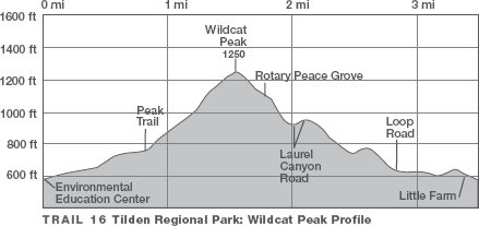
The Peak Trail climbs moderately along the edge of a steep canyon, rising from the eucalyptus forest into native oak–bay woodland and chaparral. Several long switchbacks rise almost to the ridgetop. At a T-junction, 4 turn left and climb about 100 yards to the summit of Wildcat Peak (1250'), where there are stone benches and a fine view of the Golden Gate, San Francisco Bay, and the neighboring cities.
 Great Views
After spending time on the summit, retrace your route to the previous junction, then angle left on the Peak Trail, now a dirt road. East and below the summit of Wildcat Peak is the Rotary Peace Grove, a planting of giant sequoias honoring people who have made “outstanding contributions to world peace.” 5 Because these trees are out of their habitat, they will never attain giant status like their cousins in Yosemite and Sequoia national parks.
Tilden’s child-friendly trails are labeled with whimsical pictures–a duck for the Jewel Lake Trail, a tree for the Sylvan Trail, a summit for the Peak Trail, and a bay leaf for the Laurel Canyon Trail.
About 70 yards past the Rotary Peace Grove, near a stand of eucalyptus, veer right on the single-track Peak Trail, leaving the dirt road (which joins Nimitz Way in about 30 yards or so). After a steep, brushy section the trail levels, crosses an open hillside, and then drops to Laurel Canyon Road. 6 Turn left, go about 300 yards, and reach the start of the Laurel Canyon Trail, on which you turn right.
 7
7
 Canyon
The narrow, single track descends along the steep edge of Laurel Canyon to where a bridge takes you to the south side of Laurel Creek, where you may find thimbleberries and blackberries in summer. Descending into a shady forest, you angle left at a junction with a trail to Laurel Canyon Road, right. 8 Past a marshy meadow, the Pine Tree Trail heads left, but you descend straight on the Laurel Canyon Trail, on a rolling course to Loop Road.
 9 Here you turn left and walk about 100 feet to the continuation of the Laurel Canyon Trail, right and marked by a trail post. This single track makes an easy descent through eucalyptus and coast live oak to a dirt road.
 10 Turn left and follow this road past an unsigned dirt road heading right. Just ahead is the fence at the corner of Little Farm, which is an animal-petting area that delights kids and adults alike. Here turn right and go about 0.2 mile downhill through the Little Farm to the Environmental Education Center, right.
 11
11
 Stream
 MILESTONES
Trail 16
 1 0.0 Start up Jewel Lake Trail, then stay left on this trail as Laurel Canyon and Pine Tree trails go right
 2 0.1 Right on Sylvan Trail
 3 0.5 Right on Peak Trail
 4 1.4 Left at T-junction to summit of Wildcat Peak (1250'), then retrace to previous junction and go straight on Peak Trail
 5 1.6 Pass Rotary Peace Grove on left, then right on single-track Peak Trail
 6 1.9 Left on Laurel Canyon Rd.
 7 2.0 Right on Laurel Canyon Trail
 8 2.4 Left to stay on Laurel Canyon Trail
 9 2.8 Left on Loop Rd., then right on Laurel Canyon Trail
 10 3.1 Left on dirt road to Little Farm fence, then right
 11 3.3 Back to visitor center