TRAIL 18 East Bay
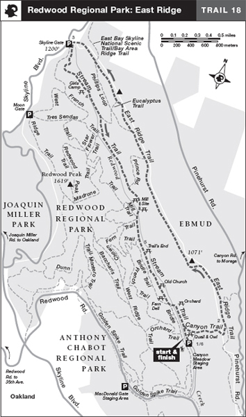
Redwood Regional Park: East Ridge
TRAIL USE
Hike, Run, Dogs Allowed
LENGTH
6.0 miles, 3–4 hours
VERTICAL FEET
±950'
DIFFICULTY
– 1 2 3 4 5 +
TRAIL TYPE
Loop
SURFACE TYPE
Dirt, Paved
FEATURES
Fee
Stream
Birds
Great Views
FACILITIES
Restrooms
Picnic Tables
Water
Phone
This loop, using the East Ridge and Stream trails, pairs a vigorous hike along an exposed ridge with a secluded downhill ramble in the shade of tall redwoods, an unbeatable combination. Views from the East Ridge Trail of the surrounding East Bay parklands are superb, and the redwood forest along Redwood Creek, though merely a shadow of its former old-growth self, is nevertheless majestic. As a bonus, water is available not only at the trailhead but also at Skyline Gate and at picnic areas along the Stream Trail.
Best Time
This route is enjoyable all year.
Finding the Trail
From Interstate 580 southbound in Oakland, take the 35th Ave. exit, turn left and follow 35th Ave. east into the hills. After 0.8 mile 35th Ave. becomes Redwood Rd., and at 2.4 miles it crosses Skyline Blvd., where you stay in the left lane and go straight. At 4.6 miles from Interstate 580 you reach the park entrance; turn left and go 0.5 mile to the Canyon Meadow Staging Area.
From I-580 northbound in Oakland, take the Warren Freeway/Berkeley/State Hwy. 13 exit and go 0.9 mile to the Carson St./Redwood Rd. exit. From the stop sign at the end of the exit ramp, continue straight, now on Mountain Blvd., 0.2 mile, and bear right onto Redwood Rd. Go 3.2 miles to the park entrance; turn left and go 0.5 mile to the farthest parking area, the Canyon Meadow Staging Area.
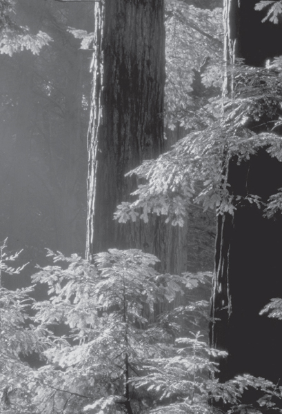
Second-growth redwoods in Redwood Regional Park have gradually reclaimed hillsides and canyons that were heavily logged in the 19th century.
From State Hwy. 13 southbound, take the Redwood Rd./Carson St. exit, turn left onto Redwood Rd. and follow the directions above.
There are fees for parking and dogs when the entrance kiosk is attended. The trailhead is on the northwest end of the parking area.
Trail Description
From the parking area, head northwest on the paved Stream Trail to a junction 1 near the restrooms. Here turn right on a dirt road signed TO CANYON TRAIL, which climbs past the Owl and Quail picnic areas. As lawns yield to wildlands, a dirt road from the parking area merges from the right. Continue climbing, now on the Canyon Trail, a well-shaded route beside California bays and coastal scrub, that starts steep but changes to moderate.
After about 0.4 mile of huffing and puffing, gain the ridgetop and join the East Ridge Trail, a wide dirt road, by bearing left.2 The route follows a rolling course along the initially viewless ridgeline, passes the Redwood Trail, right, and climbs to a rest bench with views of Mt. Diablo and Redwood Creek.
 Great Views
At about 2.4 miles, Prince Road goes left and downhill. A nearby rest bench provides views of Redwood Canyon. Your route stays straight and climbs, soon reaching a fork with the Phillips Loop, left. Here you bear right and continue climbing. Now heading through a corridor of pine, eucalyptus, and madrone, the route passes a junction with the Eucalyptus Trail, left, and begins to bend west.
With the Skyline Gate parking area in view, you pass the Phillips Loop, left, and the East Bay Skyline/Bay Area Ridge Trail, right. Nearby are toilets, a rest bench, and a phone. Ahead is a junction with the Stream and West Ridge trails, where water is available.3
Turn left on the Stream Trail and descend moderately—first through scrub and then through an oak–bay forest—to Girls Camp, a grassy meadow with a shelter and picnic tables shaded by plum and walnut trees.4 Now on a gentle descent beside Redwood Creek, you pass the Eucalyptus Trail, left. Here the vegetation changes dramatically, and you now walk in a shady forest of magnificent redwoods growing straight and tall, towering overhead. A moderate descent soon brings you to a rest bench and a junction with the Tres Sendas Trail, right. In fall, thousands of breeding ladybugs cluster on the foliage near this junction, with others flying through the air, creating a fascinating spectacle.
 Stream
 OPTIONS
More Redwood Regional Park Trails
The Stream Trail is closed to bicycles from Skyline Gate to the Trail’s End picnic area, but the West Ridge Trail is open to bicycles all the way from Skyline Gate to just below Canyon Meadow, making an 8.2-mile round trip on bicycle possible. For hikers, a shadier, more strenuous loop of 7.7 miles can be made using the Stream, French, and Orchard trails. The West Ridge Trail is part of the Bay Area Ridge Trail/East Bay Skyline Trail between Tilden and Chabot Regional Parks.
You continue straight on the Stream Trail through deep forest, crossing several bridges over Redwood Creek. After a junction with Prince Road, left, you emerge briefly into an open area, then reenter the redwood forest. Past the Mill Site group camp, you cross Redwood Creek on a rustic bridge to a T-junction with the Mill Trail, where you stay left on the Stream Trail, now a dirt road.
As you enjoy your level walk on the Stream Trail, you pass several more picnic areas and junctions with the Fern and Chown trails, both right. You reach pavement at the Trail’s End picnic area,5 and, after another 0.5 mile or so, leave the forest near the Fern Dell picnic area and shelter. Where the Bridle Trail goes right, you stay left on the paved Stream Trail, signed TO CANYON MEADOW, on a bridge over Redwood Creek. The Stream Trail curves past a children’s play area and the Orchard picnic area, and then, after a final shady grove, closes the loop at the restrooms. From here, go straight and retrace your route to the parking area.6
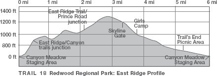
 MILESTONES
Trail 18
1 0.0 Take paved Stream Trail northwest, then right on Canyon Trail
2 0.4 Left on East Ridge Trail
3 3.3 Skyline Gate; go left on Stream Trail
4 3.7 Girls Camp
5 5.2 Stream Trail becomes paved near Trail’s End picnic area
6 6.0 Junction with Canyon Trail, left; go straight to parking area