TRAIL 2 North Bay
Muir Woods National Monument: Dipsea Trail
TRAIL USE
Hike
LENGTH
4.0 miles, 3 hours
VERTICAL FEET
±925'
DIFFICULTY
– 1 2 3 4 5 +
TRAIL TYPE
Loop
SURFACE TYPE
Dirt, Paved
FEATURES
Stream
Canyon
Birds
Historic
Cool & Shady
FACILITIES
Visitor Center
Park Store
Snack Bar
Restrooms
Water
Phone
This loop climbs across high meadows on a stretch of the famous Dipsea footrace route, then descends through old-growth coast redwoods to the bustle and grandeur of Muir Woods National Monument.
Best Time
Spring through fall. In summer expect fog and tourists—parking areas fill by midmorning. In winter, when Redwood Creek may be too deep to cross, use the alternate route described below.
Finding the Trail
From US Hwy. 101 northbound in Mill Valley, take the State Hwy. 1/Mill Valley/Stinson Beach exit (which is also signed for Muir Woods and Mt. Tamalpais). After exiting, stay in the right lane as you go under US 101. At about 1 mile from US 101, get in the left lane, and, at a stoplight, follow Shoreline Hwy. as it turns left.
Continue 2.7 miles to Panoramic Hwy. and turn right. At 0.8 mile on Panoramic Hwy., where the road splits in three directions, turn left down Muir Woods Rd. After 1.6 miles you come to a hairpin turn where Muir Woods Rd. turns left, but you go straight and park in the main parking area for Muir Woods National Monument. If there’s a long line of cars, instead turn sharply left on Muir Woods Rd. and go another 100 yards to the overflow parking area, right. If this lot is full, continue south and look for roadside parking (possibly as far south as the Deer Park Fire Rd.). A trail along the west side of Muir Woods Rd. will take you north to the overflow and main parking areas.
From Hwy. 101 southbound in Mill Valley, take the Hwy. 1 North/Stinson Beach exit (which is also signed for Muir Woods and Mt. Tamalpais). After exiting, bear right, go 0.1 mile to a stop sign, and bear left on Hwy. 1. Go 0.5 mile, get in the left lane, and, at a stoplight, follow Shoreline Hwy. as it turns left. Then follow the directions in the second paragraph above.
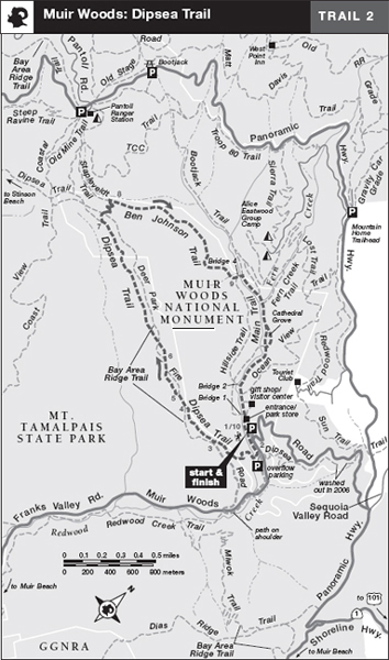
The trailhead is a paved path on the west side of the main parking area, 1 but if you park at the overflow parking area (or beyond), start from the Dipsea Trail information board at the northwest corner of the overflow parking area.2 The ranger station at the entrance to Muir Woods National Monument posts current trail conditions; there is a park store with books and maps. Because you will enter Muir Woods National Monument via the “back door,” you won’t be required to pay admission, but you may leave a suitable donation in the box by the exit path when you reach it.
On weekends and holidays from May through September, consider taking Golden Gate Transit’s free Muir Woods shuttle from Marin City to the Muir Woods National Monument entrance. In summer, some Golden Gate Transit shuttles to Muir Woods also depart from the Sausalito ferry terminal.
Trail Description
From the west side of the main parking area,1 head south on a paved path past restrooms and through a shady grove. In 100 yards you come to the overflow parking area,2 where the Dipsea Trail from Mill Valley enters left. Now on the Dipsea Trail, go straight another 50 feet, then descend right on wooden steps and cross alder-shaded Redwood Creek on a low, log footbridge. Although an easy crossing from spring through fall, it is impossible to cross here in winter when the creek flows over the log. (Check at the ranger station for current conditions and see below for an alternate winter route.)
Stretching 7.1 miles from Mill Valley to Stinson Beach, the Dipsea Trail is the route of a rugged footrace, held nearly every year since 1905.
Safely across the creek, the Dipsea Trail crosses a gravelly flood plain, then ascends on a moderately steep grade toward the ridgeline through a forest of California bay and Douglas-fir. After 0.3 mile, your single-track trail comes alongside the Deer Park Fire Road3 but does not join it. Stay right on the Dipsea Trail and climb across open coastal scrub and meadows at the edge of the forest.
Soon this segment of the Dipsea Trail ends at a T-junction.4 Turn right and continue west on Deer Park Fire Road for 100 yards. As the road bends right, stay straight on another short segment of the Dipsea Trail,5 which climbs across a meadow then rejoins the road about 500 feet ahead.
Angle left on the Deer Park Fire Road for about 400 feet, now in forest. As the road bends left, the Dipsea Trail6 ascends right at an unsigned junction. Follow this single-track trail through a pine grove and then out into coastal scrub. Just ahead, Deer Park Fire Road crosses your trail, ascending from left to right, but you continue straight. Now the Dipsea Trail begins a long, easy ascent across a wide meadow, edged by Douglas-fir and California bay. After about 0.5 mile you leave the meadow, dip to cross a stream, and then begin a steady climb amid tall conifers. Along the trail, several Douglas-firs have been toppled by winter storms, exposing their roots and opening the shady canopy for sun-loving shrubs such as huckleberry.
 Stream
On level ground you come to a junction where you turn right on the Ben Johnson Trail.7 In a few steps you cross Deer Park Fire Road at the upper edge of a magnificent coast redwood forest. Straight ahead, the Ben Johnson Trail plunges steeply via a dozen switchbacks to a sheltered grove and a junction with the Stapleveldt Trail, left.8
Turn right and continue down the Ben Johnson Trail, which descends easily across hillsides and gulches as the main canyon of Redwood Creek drops left. After nearly a mile of relative solitude amid the redwoods, you descend past the Hillside Trail, right, and arrive at Bridge 4 across Redwood Creek. A few steps past the bridge is a T-junction with the Bootjack and Main Trails.9
Turn right on the Main Trail, a paved path that winds between the stately old-growth giants and follows the east bank of Redwood Creek. From here you will share the trail with a steady stream of visitors from all over the world. Split-rail fences line the trail to keep people from trampling the fragile tree roots.
Amid the enormous redwoods, look for shade-loving deciduous trees including California bay, alder, and bigleaf maple. You may notice many dead, mature tanbark oaks, along with young tanbark oak saplings still sprouting.
Along the last mile of this loop, the Camp Eastwood and Fern trails enter left, then Bridges 3 and 2 head right to the west side of the creek. In winter these bridges are good places to look for migratory steelhead and salmon.
 OPTIONS
Winter Detour
When the Dipsea Trail footbridge across Redwood Creek is flooded, one alternative is to hike south to the overflow lot2 then detour left and turn right along Muir Woods Rd. For the first 0.3 mile, you follow a wide, fenced trail along the east shoulder. Then, after crossing Redwood Creek, you continue south along the left shoulder, facing traffic. Another 0.2 mile ahead you pass a trailhead for Redwood Creek Trail to the left. Here turn right, carefully cross the road, and ascend the Deer Park Fire Rd., a gravel road. About 0.5 mile up the ridge the Dipsea Trail appears on the right; follow either the trail or road 0.3 mile farther to the formal junction3 then follow the described route. This variation totals 4.7 miles, with ±965 vertical feet.
A simpler alternative is to hike the last half of this trail in reverse. Enter Muir Woods National Monument and follow the Main Trail 1 mile along Redwood Creek. At Bridge 4, turn left up the Ben Johnson Trail as far as you like, then retrace your route.
Stream
Just after the Ocean View Trail enters left, the Main Trail joins a wooden boardwalk. Spurs branch left to the gift shop, snack bar, and restrooms, and right to Bridge 1. Continue straight on the Main Trail to the main entrance, park store, and main parking area.10
 Cool and Shady
To return to the overflow lot, follow the paved path on the west edge of the main parking area past the restrooms, then turn left at the Dipsea Trail junction to the overflow lot. If you parked farther south, walk to the entrance of the overflow lot, then turn right on the gravel path that parallels Muir Woods Road.
 MILESTONES
Trail 2
1 0.0 From west edge of main parking area, take paved path south past restrooms
2 0.1 Dipsea Trail enters on left; continue straight on Dipsea Trail, which bends right across Redwood Creek
3 0.4 Deer Park Fire Rd. appears left briefly; stay right on Dipsea Trail
4 0.6 Dipsea Trail ends at T-junction; turn right on Deer Park Fire Rd.
5 0.7 Stay left on single-track Dipsea Trail, then angle left on Deer Park Fire Rd.
6 0.9 Angle right on single-track Dipsea Trail; stay straight 100 yards ahead as you cross Deer Park Fire Rd.
7 1.7 Right on Ben Johnson Trail; go straight across Deer Park Fire Rd. and descend switchbacks
8 2.0 Stapleveldt Trail goes left; stay right on Ben Johnson Trail
9 2.9 Stay straight past Hillside Trail to Bridge 4, then turn right on Main Trail
10 4.0 Back at ranger station, entrance, and main parking area