TRAIL 24 East Bay
Dry Creek Pioneer Regional Park: High Ridge Loop
TRAIL USE
Hike, Run, Bike, Dogs Allowed
LENGTH
5.7 miles, 3–4 hours
VERTICAL FEET
±1100'
DIFFICULTY
– 1 2 3 4 5 +
TRAIL TYPE
Loop
SURFACE TYPE
Dirt
FEATURES
Fee
Lake
Summit
Birds
Wildlife
Great Views
Secluded
FACILITIES
Visitor Center
Restrooms
Picnic Tables
Water
Phone
This route explores a regional-park gem—an oasis in the middle of one of the East Bay’s most heavily industrial and residential areas. Scenery, views, and variety of habitat combine to make hiking these ridges more than just a challenging workout. An optional ascent of Tolman Peak will reward those wanting a longer route.
Best Time
Spring and fall, but trails may be muddy in wet weather.
Finding the Trail
From Interstate 580 eastbound in Castro Valley, take the Hayward/State Hwy. 238 exit and follow signs for Hayward. From the first traffic light, continue straight, now on Foothill Blvd., for 1.7 miles to Mission Blvd., staying in the left lanes as you approach Mission Blvd. Bear left onto Mission Blvd. and go 3.5 miles to Garin Ave. Turn left and go 0.9 mile uphill to the entrance kiosk. At the kiosk bear right and proceed to parking areas; park in the lowest area if space is available.
From I-580 westbound in Castro Valley, take the Strobridge exit and go 0.2 mile to the first stop sign. Turn right, go 0.1 mile to Castro Valley Blvd., and turn left. Follow Castro Valley Blvd. 0.5 mile to Foothill Blvd., turn left, and follow the directions above. The park charges fees for parking and dogs when the entrance kiosk is attended.
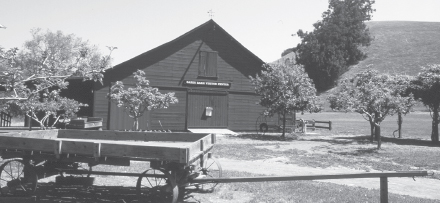
To find the trailhead, go to the northeast corner of the lower parking area, turn east and cross a creek on a wooden bridge, then continue straight on a path into a picnic area. The route starts at the visitor center, a big red barn about 100 yards north of the wooden bridge.
Trail Description
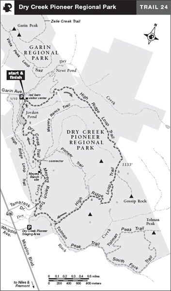
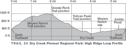
From just south of the visitor center, follow a dirt road heading east across a large meadow to a metal gate. When you come to a four-way junction with a gravel road, 1 continue straight and begin climbing the High Ridge Loop Trail, a dirt road with a grassy gulch on the right. At about 0.5 mile the grade eases briefly, and the Newt Pond Trail enters on your left.
 2 Soon the route levels, turns southeast, and then passes a junction, at about 1.1 miles, with the Meyers Ranch Trail, right. Ground squirrels abound in the open pastures.
 Wildlife
Near the start of the climb, perhaps only the distant blue blur of the Santa Cruz Mountains were visible above a strip of San Francisco Bay. But as you continue, a grand scene is revealed—San Francisco Bay National Wildlife Refuge, Coyote Hills, the Dumbarton and San Mateo bridges, Fremont, Newark, and Union City. On a clear day even Mt. Tamalpais, Mt. Diablo, and Loma Prieta may present themselves for inspection.
 Great Views
A short climb earns your first view of Mission Peak, to the southeast, and the southern end of San Francisco Bay. Ahead is a junction with the Gossip Rock Trail, which goes left. 3 There is a rest bench here, but on a hot day you may want to walk the short distance to Gossip Rock and enjoy the shade of the large California bay trees there.


Garin/Dry Creek visitor center, in a restored barn, has displays of antique farm equipment and information about Hayward’s ranching and farming history.
Leaving the junction and going straight, you descend moderately through open grassland, flanked by wooded canyons. About 0.5 mile past the Gossip Rock Trail, bear sharply right at a junction with an unnamed road and continue downhill, now steeply. Scrubland soon gives way to a shady oak woodland. In a lovely valley, the Pioneer Trail departs right, and your route continues straight. 4 The trail emerges from the woods and reaches a T-junction near a stock pond.
 5 Here the Tolman Peak Trail goes left, but your route, the High Ridge Loop Trail, turns right.
Climbing on a gentle grade, the road crosses a grassy slope with a view west, then descends. Where the May Trail descends left to the Dry Creek Pioneer Staging Area, you bear sharply right. After crossing Dry Creek, you reach a four-way junction. 6 Left is a gate leading to Tamarack Drive. Ahead and slightly left, the High Ridge Loop Trail ascends a high, open ridge (bicyclists angle left up this dirt road about 1 mile, then veer right as it descends to Jordan Pond; turn right to cross the dam and rejoin the hiking route).
Hikers bear right on the Meyers Ranch Trail. The dirt road descends gently, then crosses a series of bridges over meandering Dry Creek, and ducks in and out of trees in a pastoral valley. In about 0.5 mile, you come to an open area signed for Meyers Ranch; 7 look for rusted, antique farm equipment lying in the grass to your right. Although no buildings remain, planted poplars and fruit trees show this was once a homestead.
After leaving the Meyers Ranch site, find a single track on your left signed DRY CREEK TRAIL. Hikers descend this narrow connector, which is closed to bikes, and cross Dry Creek on a narrow footbridge (an alternate equestrian trail fords the creek to the right of the bridge). Several hundred feet past the bridge is a T-junction with the Dry Creek Trail. 8 Here you turn right, toward Jordan Pond and the visitor center.
 OPTIONS
Tolman Peak
The side trip to Tolman Peak adds 3.9 miles and an elevation gain and loss of 800 feet to the trip. Turning left on the Tolman Peak Trail,  5 a dirt-and-gravel road, you pass a stock pond and amble through Black Creek Valley. Beyond a cattle pen, left, eucalyptus at an old ranch site provide a shady resting place. Beyond a gate, the road crosses a creek on a small bridge and then twice crosses the rocky creek bed itself. Soon the Tolman Peak Trail turns left, but you continue straight on the dirt road you have been following, now called the South Fork Trail. The road continues up the canyon another 0.5 mile or so to a bench at the regional-park boundary. Bicyclists, and hikers seeking just a creekside saunter, should turn back here and retrace your route through Black Creek Valley to the High Ridge Loop Trail, for a 2.8-mile side trip.
Energetic hikers turn left on the South Fork Trail, now a single track, and climb across a steep hillside. Once out of the forest, the trail may be hard to spot: Look for a line of matted grass. A bench affording a grand view of San Francisco Bay and the regional park’s nearby canyons marks the trail’s high point. Gossip Rock, which you passed earlier, is to the north. Just past the bench is a T-junction with the Tolman Peak Trail, a faint path that leads right and uphill to Tolman Peak. (The 0.2-mile side trip to the very summit is fun but does not gain you any better views.)
As you wind downhill on a moderate and then steep grade, you follow a small creek to close the short loop at a junction with the South Fork Trail. From here, turn right and retrace your route through Black Creek Valley to the junction with the High Ridge Loop Trail.  5
5
Your route now winds through a shady area and crosses the creek on another wooden bridge. After traversing a low ridge, you come to a grove of bay trees. Here one branch of the trail leads straight to a horse crossing at the creek, but you turn left and cross the creek on a wooden bridge.
Once across the creek, turn right and, at a big rock, join the path coming from the horse crossing. Ahead the trail forks again: right for horses, straight for hikers. One last bridge takes you over the creek, and soon, heading straight, you ascend a paved section of trail and reach a T-junction at Jordan Pond. 9
9
 Lake
Lake
Here the High Ridge Loop Trail goes left, but you turn right and begin circling the pond on a dirt road, through an area of picnic tables and fire grates. Past the upstream end of the pond, you come to a fork in the route: bear right through the picnic area to return to the visitor center, then turn left to the parking area. 10
10
 MILESTONES
Trail 24
 1 0.0 Start southeast, through gate, up High Ridge Loop Trail
 2 0.5 Newt Pond Trail on left
 3 2.1 Trail to Gossip Rock on left
 4 2.9 Straight at T-junction with Pioneer Trail
 5 3.5 Right at T-junction to stay on High Ridge Loop Trail
 6 4.0 Right on Meyers Ranch Trail
 7 4.5 Meyers Ranch
 8 4.7 Right at T-junction with Dry Creek Trail
 9 5.4 Jordan Pond; right at T-junction, then right at fork
 10 5.7 Back at visitor center