TRAIL 29 South Bay
Joseph D. Grant County Park
TRAIL USE
Hike, Run, Bike
LENGTH
9.8 miles, 4–6 hours
VERTICAL FEET
±1650'
DIFFICULTY
– 1 2 3 4 5 +
TRAIL TYPE
Loop
SURFACE TYPE
Dirt
FEATURES
Summit
Birds
Great Views
Secluded
Camping
FACILITIES
Restrooms
Picnic Tables
Water
Phone
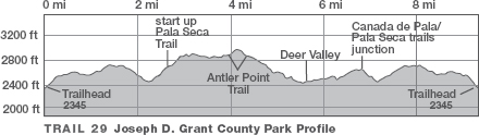
Following a mostly rolling, ridgetop course on the Canada de Pala and Pala Seca trails, you enjoy views of the Diablo Range, crowned by nearby Mt. Hamilton, and the distant Santa Cruz Mountains. From Antler Point, the trail dips into lovely Deer Valley but soon resumes its quest of high places. Camping is available in the park’s main area. For reservations, phone (408) 355-2201 or reserve online at www.gooutsideandplay.org.
Best Time
Fall through spring.
Finding the Trail
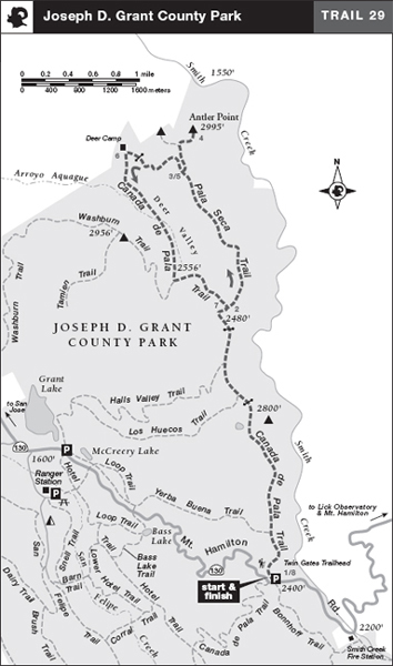
From Interstate 680 in San Jose, take the Alum Rock exit, go northeast 2.2 miles to Mt. Hamilton Rd., and turn right. At 7.7 miles you pass the entrance to the park’s main area. Continue another 3.4 miles to a paved parking area, left, for the Twin Gates Trailhead. The trailhead is on the west side of the parking area.
Trail Description
From the trailhead, 1 go through a metal gate and then climb moderately on the Canada de Pala Trail, a dirt road. The road bends right and gains the top of a ridge. Mt. Hamilton, a hulking giant topped by 4373-foot Copernicus Peak, rises to your east. The white domes clustered around Mt. Hamilton’s summit belong to University of California’s Lick Observatory.
If the Santa Clara Valley is foggy, you may be reveling under clear skies with views of the Santa Cruz Mountains to the west.
Soon the grade eases, and you enjoy a rolling course over mostly open, grassy terrain. At a junction with the Yerba Buena Trail, left, you continue straight, eventually passing a rest bench and a stock pond, both left. After passing through a cattle gate, you descend past a junction, left, with the Los Huecos Trail, a dirt road. Continuing straight and steadily losing elevation, you pass the Halls Valley Trail, left, and then a saddle in the ridge you’ve been following.
Climbing to a junction where the Canada de Pala Trail2 bends left, you continue straight, now on the Pala Seca Trail. This trail, also a dirt road, climbs moderately and then steeply, still following the crest of a ridge. A rest bench, right, invites you to stay awhile and relish the scenery.
 Summit
The road levels, curves right, and then begins to descend. Twin summits are just ahead, the right one being Antler Point. You reach it via the Antler Point Trail, a single track angling right.3 This trail wanders across a hillside and soon reaches an unsigned fork. You bear right on the less prominent trail and climb gently for 0.2 mile to trail’s end.4 (The left-hand trail also leads to a summit, with a rest bench.) The view northward from Antler Point takes in a rugged ensemble of canyons, ravines, and ridges that make up some of the wildest land in the Bay Area. After enjoying this invigorating scene, retrace your route to the Pala Seca Trail.5
 Great Views
From the Canada de Pala Trail you can see two Bay Area mountain ranges—the Diablo Range and the Santa Cruz Mountains.
Now you make a hard right on the dirt road, pass a rest bench, and begin to descend via S-bends. In places the road is rocky, eroded, and perhaps muddy where a creek trickles across. After losing elevation, you climb on a gentle grade to a barbed-wire fence and a cattle gate. Once through the gate, you pass Deer Camp, site of an old hunting cabin that has a picnic table on its shady back porch.6 Here the Pala Seca Trail ends and blends seamlessly into the Canada de Pala Trail. Resuming the descent, you drop steeply into a ravine, then cross a low divide and enter beautiful, wide Deer Valley. Soon you are beside a creek that creates a marshy tract of sedges and rushes. A culvert carries the creek under the road and puts it on your left.
 Stream
A wet meadow, left, marks the head of the creek. An extensive ground squirrel colony is nearby. Now you pass a junction with the Washburn Trail, a dirt road heading right. You continue straight and climb out of the valley at its south end. Soon you reach a cattle gate, and just beyond is the junction with the Pala Seca Trail.7 From here, bear right and retrace your route along the rolling ridge to the parking area.8
 Wildlife
 MILESTONES
Trail 29
1 0.0 Take the Canada de Pala Trail
2 2.6 Straight on Pala Seca Trail
3 4.2 Right on trail to Antler Point
4 4.4 Antler Point; retrace to previous junction
5 4.6 Right on Pala Seca Trail
6 5.3 Deer Camp, straight on Canada de Pala Trail
7 7.2 Right to stay on Canada de Pala Trail, retrace to parking area
8 9.8 Back at parking area