TRAIL 34 Peninsula
Monte Bello Open Space Preserve
TRAIL USE
Hike, Run
LENGTH
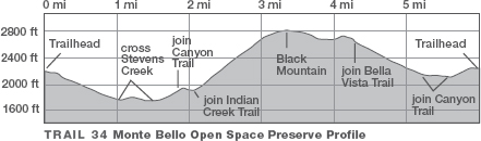
6.0 miles, 3–4 hours
VERTICAL FEET
±1400'
DIFFICULTY
– 1 2 3 4 5 +
TRAIL TYPE
Loop
SURFACE TYPE
Dirt
FEATURES
Stream
Canyon
Mountain
Summit
Autumn Colors
Wildflowers
Birds
Geologic Interest
Great Views
Photo Opportunity
Camping
FACILITIES
Restrooms
This challenging but supremely rewarding loop explores the riparian corridor of Stevens Creek, formed by the San Andreas Fault, and the windswept grasslands of Monte Bello Ridge, which forms the scenic backdrop for Sunnyvale, Cupertino, and Mountain View. The views from Black Mountain are superb, and the descent along the Old Ranch and Bella Vista trails offers some of the best hiking on the Peninsula.
Best Time
Spring and fall; Stevens Creek may be impassable in wet weather.
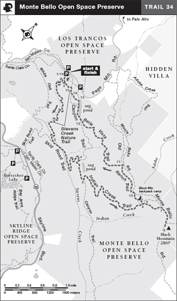
Finding the Trail
From Interstate 280 in Los Altos Hills, take the Page Mill Rd./Arastradero Rd. exit and go south on Page Mill Rd. 7.2 miles to a parking area on your left.
From the junction of Skyline Blvd. and Page Mill Rd. southwest of Palo Alto, take Page Mill Rd. north 1.4 miles to a parking area on your right.
The hikers trailhead is on the south corner of the parking area, near information boards and a map holder. (A separate bicycle/equestrian trailhead is near the entrance to the parking area.)
Trail Description
From the trailhead, 1 follow the single-track Stevens Creek Nature Trail through open grassland. Along the way are signs describing the flora, fauna, and geology of this wonderful preserve.
Near a rest bench is a junction,2 where you turn sharply right and stay on the Stevens Creek Nature Trail, signed TO SKID ROAD TRAIL. Now descending via switchbacks, you soon enter a mixed evergreen forest. A canyon, right, holds a seasonal tributary of Stevens Creek. A sharp left-hand bend brings you to a set of wooden steps leading down to Stevens Creek, which formed along the San Andreas Fault. After crossing Stevens Creek on rocks (this may be impossible during wet weather), you climb an eroded bank to get back on the trail. A moderate climb that soon levels brings you to a junction with the Skid Road Trail, where you bear left.3
 Canyon
Now a bridge takes you across Stevens Creek, and then the route temporarily narrows to single-track width. A moderate climb brings you to a bridge over a tributary that falls from Monte Bello Ridge. Curving right and climbing steeply, the trail takes you across a precipitous hillside and soon returns to dirt-road width.
 Stream
Now ascending via S-bends, you reach a seasonal-closure gate that prevents access to the Skid Road Trail by bikes and horses during wet weather. In a clearing, you find a T-junction with the Canyon Trail, a dirt road.4 Here you turn right.
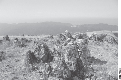
Prominent limestone outcroppings at Black Mountain
The Canyon Trail angles left and almost immediately begins a steep climb that soon relents enough to provide an enjoyable ramble through wooded and open terrain. At a T-junction,5 the Canyon Trail turns right, but you switch to the Indian Creek Trail, also a dirt road, by veering left. Now you begin a long, steady climb up the side of Monte Bello Ridge, which parallels the San Andreas Fault. A sea of coastal scrub studded with venerable valley oaks and young madrones soon yields to stands of chaparral, including chamise, toyon, and buckbrush.
 HISTORY
Skid Road
Skid Road was used by loggers driving teams of oxen dragging huge, cut Douglas-firs. To make the going easier, the road was inlaid with flat-topped logs called “skids,” which were doused with water to reduce friction. In 19th-century western towns, the neighborhood frequented by loggers, which usually contained saloons, flophouses, and brothels, was often called Skid Road, or Skid Row.
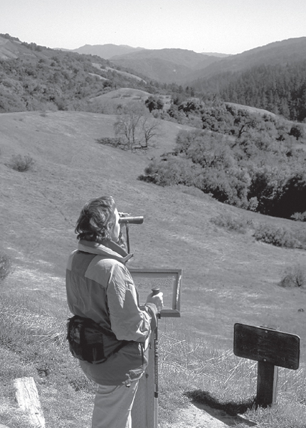
The view across Stevens Creek headwaters follows the San Andreas Fault.
The road eventually reaches two closely spaced junctions. At the first, a single-track trail leads left to Monte Bello Road. At the second, a dirt road veers left.6 To reach the Black Mountain backpack camp and a well-deserved rest spot, turn left on this dirt road. After about 100 feet, you come to a T-junction with a gravel road, where you turn left to reach the camp.
 Camping
To press on to the summit of Black Mountain and save the backpack camp for later, stay on the Indian Creek Trail as it curves right and climbs past the turnoff to the backpack camp. The Indian Creek Trail ends at the next junction,7 where you join Monte Bello Road by bearing right. Continuing straight past the Black Mountain Trail, left, you soon stand atop Black Mountain, a broad, treeless vantage point studded with limestone outcrops.8 After soaking in the 360-degree views, retrace your route to the backpack-camp junction.9
 Mountain
 Great Views
Here turn right and, after about 100 feet, meet the gravel road at the T-junction mentioned above. Turn left and walk through the backpack camp. Just past the camp, you pass the single-track connector to the Indian Creek Trail, left. Continuing straight, you follow the ridgetop to a four-way junction.10 Here, Monte Bello Road joins sharply from the right and continues by veering right. Your route, though, is the single-track Old Ranch Trail, which angles left.
At the next junction,11 you swing left onto the Bella Vista Trail, a single track that descends northwest across steep, grassy slopes and dips into shaded gulches.
From Black Mountain, on a clear day, you can see most of the San Francisco Bay Area, bounded by Mt. Tamalpais, Mt. Diablo, and Mt. Hamilton.
Finally reaching the Canyon Trail, a dirt road, you angle right.12 After passing a seasonal wetland called a sag pond, where a rest bench awaits, you pass a junction with a hiking-only trail on the left. Continue straight for about 100 yards and then turn left on the Stevens Creek Nature Trail,13 a multiuse single track that passes through an old orchard of mostly English walnut trees.
Soon the hiking-only trail joins, left,14 and you bear right to make a rising traverse across an open slope. The nearby grasslands are decorated in spring and summer with wildflowers such as California poppy, checker mallow, owl’s clover, bluedicks, and blue-eyed grass. At the next junction, equestrians and bicyclists go straight, contouring around the north side of a knoll to the parking area, but hikers turn left on a single-track trail overlooking the canyon holding Stevens Creek. Ahead, you close the loop at a familiar junction; veer right15 and retrace your route to the parking area.16
 Wildflowers
OPTIONS
More of Monte Bello
The 3-mile Stevens Creek Nature Trail is a great introductory hike by itself. From the end of the Skid Road Trail4 turn left up the Canyon Trail. After 0.5 mile you come to the end of the Bella Vista Trail12 and resume the described route.
Camping at Black Mountain backpack camp is by advance reservation only. The campground has picnic tables and a restroom but no water. Call the Midpeninsula Regional Open Space District office: (650) 691-1200.
 MILESTONES
Trail 34
1 0.0 Take Stevens Creek Nature Trail
2 0.1 Right to stay on Stevens Creek Nature Trail at start of loop
3 1.2 Left on Skid Rd. Trail
4 1.8 Right on Canyon Trail
5 2.0 Left on Indian Creek Trail
6 3.0 Road to Black Mountain backpack camp on left
7 3.2 Right on Monte Bello Rd.
8 3.5 Summit of Black Mountain (2800')
9 4.0 Retrace to backpack-camp junction; right on dirt road, then left on gravel road through camp
10 4.1 Left on Old Ranch Trail
11 4.6 Left on Bella Vista Trail
12 5.4 Right on Canyon Trail
13 5.6 Left on Stevens Creek Nature Trail
14 5.8 Bear right where hiking-only trail joins from left
15 5.9 Right on Stevens Creek Nature Trail at end of loop
16 6.0 Back at parking area